Earth ChangesS


Tornado1

Cyclone Ula: Hundreds evacuated as first Pacific cyclone of 2016 slams into Tonga

cyclone ula damage
© Tusi Finikaso/FacebookThe cyclone reportedly damaged 40 homes in Tuvalu.
Hundreds of people have evacuated from their homes in Tonga as severe tropical cyclone Ula slammed into the tiny Pacific kingdom.

There are no reported casualties as Prime Minister Akilisi Pohiva declared a state of emergency before the storm hit "in order to prevent or minimise the loss of human life, illness or injury".

The northern island of Vava'u took the brunt of the category three cyclone which was packing winds up to 150 kilometres per hour.

"We are very happy that there are no casualties, police checked with hospitals and town officers to confirm that," the chairman of the National Emergency Management Office, Siaosi Sovaleni, told a press conference.

"We had 11 evacuation centres, over 390 people were relocated to these evacuation centres."

Ula formed early on Thursday in the South Pacific between Tuvalu and Samoa and was initially expected to remain a category one storm as it tracked west-south-westerly.

However, it intensified to category two late on Thursday then to category three as it approached Tonga.

Attention

Signs and portents: Europe's winter warmth puts nature in tailspin

warm winter europe
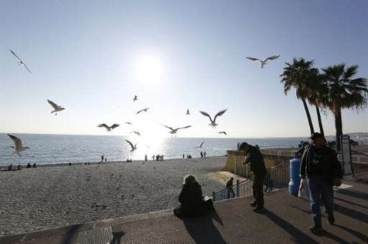
People enjoy the sun and warm temperatures on the "Promenade des Anglais" in Nice, southeastern France, on December 28, 2015
The daffodils are out in London, plum trees are blossoming in Milan and asparagus tips are pushing through the soil in eastern France.

Across Europe, unseasonably warm winter weather has left the natural world in a spin with plants, insects and animals convinced Spring must be just around the corner.

The disruption of established weather patterns has put strawberries on festive menus in France, ensured an abundance of game in Germany's woodlands and seen tomatoes ripen for an exceptional third time this year on Italian balconies.

With grass still growing in the north of Scotland well into December, the famous Royal Dornoch links put the traditional switch to winter greens on hold and kept its mowers buzzing into the final days of 2015.

But alongside the serendipitous consequences for gourmets and golfers, unusual climatic conditions have also been linked to more unsettling trends.

Comment: As the Earth's weather patterns become more chaotic, there can be wild temperature swings, but the general trend is still to cooling. It will be interesting to see whether this trend continues or ends abruptly.


Attention

Magnitude 5.8 earthquake hits near New Zealand's coast

Earthquake graph
© Science Photo Library
A 5.8-magnitude earthquake on Friday struck New Zealand's coast, the United States Geological Survey (USGS) said.

Tremors were registered at 15:02 GMT.

The epicenter was located about 50 miles north-east of Raoul Island at the depth of approximately 61 miles.

No information about the damage or casualties was immediately available.

Parts of New Zealand lie on the so-called Ring of Fire, a horseshoe-shaped string of volcanoes around the Pacific Rim, where about 90 percent of the world's quakes occur.

Comment: Strong 6.4 magnitude earthquake strikes Indian Ocean south of Australia


Fire

Colombia under red alert due to drastic drop in water levels and forest fires in Andes mountains

El Cisne lake colombia, drought
A drought caused by El Nino exposes the bed of the El Cisne lake in Colombia, July 31, 2014.
Colombia has issued a red alert in the aftermath of low water levels in the country's main rivers and forest fires burning across the Andes Mountains.

President Juan Manuel Santos made the declaration on Wednesday on the request of Institute of Hydrology, Meteorology and Environmental Studies (IDEAM).

The decision was made in the wake of a drastic drop in water levels in the two key rivers of Magdalena and Cauca, which supply hundreds of towns and cities in the South American country.

Fire

Hikers discover tree burning on the inside in Defiance, Ohio

A group of Ohio hikers happened upon a frightening sight — a tree burning from the inside. In a video of the incident (below), a tree in the woods of Defiance, Ohio, can be seen in flames as the hikers watch in shock.
Tree fire
"What the f**k," one of the hikers says. Strangely, no fire damage is evident on the outside of the tree.

"How is this even possible?" one of the hikers asks. "It's starting to get up and around." Since being posted on December 21, the 30-second clip garnered over 200,000 views.

Watch the terrifying "Devil Tree" burn below:


Comment: There doesn't appear to be much smoke either. Lightning strike? Natural gas source in the earth? An outgassing from the planet of somekind?


Question

Mysterious hole punch clouds appear over Louisiana, Mississippi and Alabama

hole in the clouds
A pretty hole in the clouds.
A series of mysterious hole punch clouds appeared in the sky of Louisiana, Mississippi and Alabama on December 29, 2015.

As if these fallstreak clouds punched gaping holes in the skies across the South.

These weird clouds form when water vapor is suspended in subfreezing air, but the vapor has not frozen because there is a lack of particles for it to freeze around.

Interesting cloud formation in Northport, Alabama.
When particles are then introduced, the vapor starts to freeze and falls towards the surface, leaving a void or hole at cloud level, but streaks of cloud underneath.

Hole punch clouds in Tuscaloosa, AL

Attention

Increased activity at 3 volcanoes in Vanuatu

Mount Yasur volcano on Tanna Island in Vanuatu
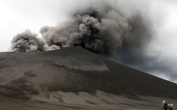
© Ulla Lohmann/ AFPA giant plume of volcanic ash billowing from Mount Yasur volcano on Tanna Island in Vanuatu on May 26, 2010.

Disaster authorities in Vanuatu are closely monitoring unprecedented simultaneous increases in activity at three of the country's volcanoes.

The Vanuatu Geohazards Department has put out level 2 alerts for both the northern and southern volcanoes of Ambrym and Tanna with local communities and tourists banned from visiting the rim of these craters.

There is a lesser level 1 alert for a volcano on Ambae island.

Geohazard officer Eslien Garaebiti says increased activity at all volcanoes has never been seen before and says the department is particularly worried about the Tanna and Ambrym craters.

Attention

Fuego volcano in Guatemala; increased activity, strombolian explosions, pyroclastic flow

Strombolian eruption at Fuego
The activity at Fuego might be picking up towards a new paroxysm (eruptive phase with strongly increased effusion rate, resulting in lava fountaining and lava flows).

We camped on the SW side of the volcano last night, and observed mild to strong strombolian explosions that occurred at intervals between 1 and 10 minutes. The strongest explosions sent incandescent material to heights of up to approx. 500 m and similar distances. One particularly intense explosion was accompanied by a very strong shock wave.

Although not seen directly from our location, a pyroclastic flow occurred around 10:15 (local time): we observed the co-ignimbrite ash plume rising from what was likely a collapse of a new lava flow on the southern slope. According to staff at the Panimache volcano observatory, who confirmed our observation, the pyroclastic flow could have reached a length of 7 km and seems to herald the start of the 14th paroxysm of Fuego in 2015... Following the initial sighting of the brownish ash plume, it gradually spread around the whole southern slopes and caused fine ash fall in the area lasting about 2 hours, graying all vegetation

Tornado1

The planet's nine category five storms of 2015: 2nd most on record

Category Five: the phase evokes an almost reverential awe in novice and seasoned hurricane watchers alike, as one considers the incredible power and majesty of these most perfect but terrifyingly destructive storms on the planet. As we look back on the year in weather, a striking feature of 2015 is the bumper crop of these fearsome storms that appeared--thanks to El Niño bringing record-warm ocean temperatures to large swaths of the Pacific Ocean.

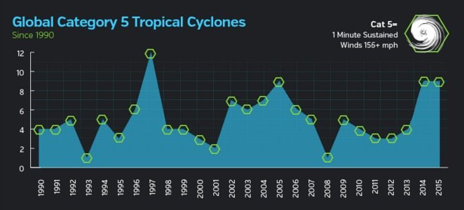
Nine Category 5 storms whipped into life over the world's oceans in 2015: five in the Northwest Pacific, one in the Northeast Pacific, one in the Southeast Pacific, and two in the South Indian Ocean. Since accurate global satellite records began in 1990, only one year has seen more. That record is held by the El Niño year of 1997, which had twelve Category 5 storms--ten of them in the Northwest Pacific. Two other season have seen nine Cat 5s--2004 and 2014. Earth averaged just 4.6 Category 5 storms per year between 1990 - 2014, according to ratings made by NOAA's National Hurricane Center and the U.S. Navy's Joint Typhoon Warning Center. The majority of these storms occur during the July - November peak of the Northern Hemisphere's tropical cyclone season, with 59% of all Cat 5s occurring in the Northwest Pacific.
Cyclones chart
© Weather UndergroundFigure 1. Global Category 5 tropical cyclones from 1990 - 2015, as rated by NOAA's National Hurricane Center and the U.S. Navy's Joint Typhoon Warning Center. There is no obvious trend in the numbers, though the past two years have seen an unusually large number of Cat 5s.
Here, then, is a "rogue's gallery" of all the Category 5 storms on Earth in 2015:
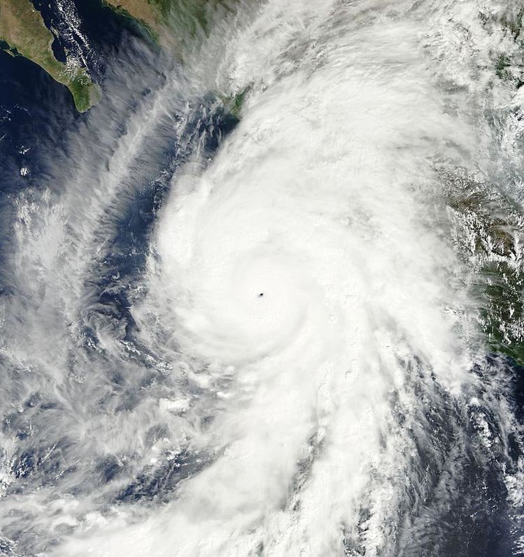
Hurricane Patricia
© NASAHurricane Patricia

Cat Five #9, Northeast Pacific


Hurricane Patricia as seen by the MODIS instrument on NASA's Terra spacecraft at 1:30 pm EDT October 23, 2015. At the time, Patricia was the most intense hurricane ever observed in the Western Hemisphere, with 200 mph sustained surface winds and a central pressure of 879 mb. Patricia made landfall in an relatively unpopulated area near Cuixmala in Southwest Mexico on October 23 as a Category 5 storm with 165 mph winds, killing fourteen and doing $300 million in damage.
Comment: NASA maps show 2015 storm season was one of extremes


Attention

17,500 earthquakes recorded for Nevada in 2015

Earthquake
More than 17,500 earthquakes were recorded in 2015 by the University of Nevada, Reno's Nevada Seismological Laboratory.

That includes the 231 recent quakes in South Reno and the magnitude 4.8 in Caliente that shook Las Vegas in January 2015, according to a Thursday report from UNR.

The biggest source of shakes is the so-called Sheldon sequence in far northwest Nevada, according to the seismological lab.

In 2015 there were 4,511 earthquakes recorded in the remote Sheldon Wildlife Refuge near Vya, east of Cedarville, Calif.

Other quake-prone areas in 2015 were Caliente, Carson City and Virginia City.