Earth ChangesS

Cloud Lightning

Lightning bolt kills four students in Uganda

Lightning
Four students of Adjumani Secondary School in Ciforo Sub-county, Adjumani District have been confirmed dead while three others sustained injuries after they were struck by lightning on Tuesday afternoon.

Mr Buni Stephen Aju, the school's deputy head teacher, identified the deceased as Isaac Chandiga, who was in Senior One, Robert Manza, Richard Edema, and Nail Majak, all Senior Two students.

"We have five lightning arrestors on different structures... but if such a heartbreaking incident can occur within the school premises, then I strongly doubt the functionality of the lightning arrestors," Mr Buni said.

Mr Ismail Yabaga, the head boy elect of the school, who witnessed the incident, said the lightning struck one of the trees near the school laboratory and it affected most of the students nearby.

Attention

Atmospheric changes: Strange cloud anomalies, rare ball lighting and more hail damaged aircraft

Mexico rainbow cloud
© YouTube/Adapt 2030 (screen capture)
Strange cloud anomalies are appearing globally with higher frequency and intensity. At the same time low cloud formation brought on by increases in cosmic rays are leading to more in-flight hail damage requiring emergency landings.


Comment: It is likely that atmospheric dust loading from increased comet and volcanic activity is contributing to the 'strange skies' we are witnessing, the cooling effect of which causes ice crystals to form. See also: Electric universe theory provides rational, intelligible explanations for such atmospheric phenomena as ball lightning, plasma discharges, noctilucent clouds, lightning, hurricanes and tornadoes. For more information on this and much more read, Earth Changes and the Human-Cosmic Connection by Pierre Lescaudron and Laura Knight-Jadczyk.


Snowflake Cold

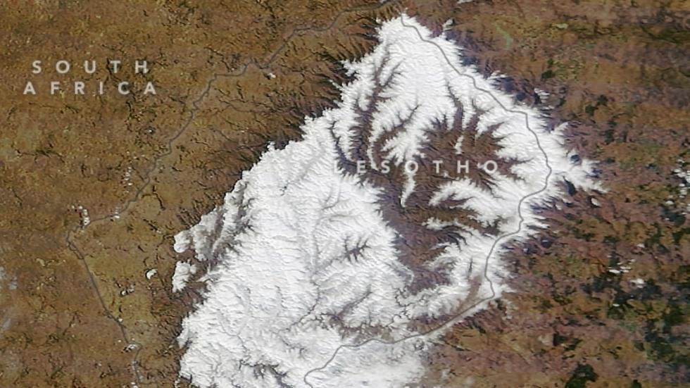
Several dead after heaviest snow in two decades hits Lesotho, Africa

Lesotho heavy snowfall
© NASA's Earth ObservatoryThe Moderate Resolution Imaging Spectroradiometer (MODIS) on NASAโ€™s Terra satellite captured this image of the heavy snow that fell on Lesotho on July 27, 2016.
A winter storm dumped more snow on Lesotho, a high-altitude kingdom surrounded by South Africa, in late July than has been seen in any snow event since 1996.

According to Traveller 24 News, at least eight tourists were airlifted as a result of the storm and the deaths of several shepherds in the Joe Gqabi District Municipality were attributed to the heavy snow that fell on July 27.

Stefan Grab, a professor at the University of the Witwatersrand in South Africa, told NASA's Earth Observatory it has been at least two decades since a storm of this magnitude hit the area, but noted that things are very different today because of how quickly the snow melts at altitudes above 5,900 feet and how infrequently the area receives any snow compared with years past.

News reports did not say how much snow fell in the country, but it was more than enough to cover the higher elevations.

"This particular snowfall was an extreme event, but it's only extreme in the context that we haven't had something like this in a long time," said Grab in the report. "In the first half of the 20th century, or certainly in the 19th century, these were very common."

According to the government's website, Lesotho is a high-altitude, hilly kingdom completely surrounded by South Africa. With typically short winters, Lesotho is comparable in size to Maryland and tends to have mild winters. In recent years, the kingdom has suffered a severe drought, which may be a contributing factor in the infrequency of heavier snowfalls.

Ice Cube

Interesting and positive changes in Arctic sea ice volume

Arctic Research Station
© NASA/JPLIn addition to satellite data from NASA's Grace mission, the scientists used measurements from Arctic Bottom Pressure Recorders deployed to the Arctic Ocean floor to monitor changes in Arctic Ocean circulation.
DMI publishes daily their Arctic ice volume data in the form of graphs. From these it is possible to retrieve the data and plot them as you like.

So, first I plotted all years available, 2003 - 2016 for the period May 16 to Aug 8 to show the melt season. Not all dates in the period was used, but enough to get the overall picture.

The first that caught my interest was obviously how 2016 was "performing" in comparison with the other years 2003 - 2015. The winter winds Nov 2015 - Feb 2016 were quite harsh to the ice as it was generally blown towards the Atlantic via East Greenland. This may explain the very low levels of ice volume May 2016. Whatever the reason for this low level of ice volume May 2016, it appears that 2016 during summer melt did not melt as fast as most other years.

Attention

Youth killed by bears in Odisha, India

Sloth bears are found in India, Nepal, Sri Lanka and Bhutan but shrinking habitats and rampant poaching have reduced their numbers
© Manpreet RomanaSloth bears are found in India, Nepal, Sri Lanka and Bhutan but shrinking habitats and rampant poaching have reduced their numbers
A youth was killed in a bear attack this morning in Odisha' Balasore district while engaged in farming land.

The deceased has been identified as Ganeswar Mallik of Budusahi village in Bhaunriabada panchayat under Nilagiri block in the district.

According to reports, two bears attacked Ganeswar from behind about 6 am today while he was channeling water to his farming land in his village.

Locals heard screams and rushed to the spot to find him profusely bleeding.

He was rushed to the local hospital where the doctor declared him dead on arrival.

Sun

The US is approaching 4,000 days since a major hurricane strike

Hurricane Wilma
© NOAAHurricane Wilma over Florida, October 24, 2005
In less than two months (October 6, 2016) it will be 4,000 days since the last time a major hurricane made landfall in the U.S., which was Wilma on October 24, 2005.

Wilma was a record-setter, being the strongest Atlantic hurricane on record, with peak estimated sustained winds of 183 mph and lowest surface pressure of 882 mb. That surface pressure corresponds to a 13% removal of atmospheric mass in the core of the hurricane compared to normal sea level pressure.

But after the record-setting 2005 Atlantic hurricane season, with a whopping 27 named tropical storms, the bottom pretty much dropped out of hurricane activity since then.

Tornado2

Waterspout seen in Sai Kung, Hong Kong

Sia Kung Hong Kong waterspout
© Siu Keung Tsui via Facebook
The skies of Sai Kung were briefly graced with a waterspout (think tornado, but over water) earlier today while the Hong Kong Observatory's Thunderstorm Warning was in place.

At around 4:55pm, Hongkongers spotted the dramatic funnel-shaped column of water rotating over the surface of the sea.

A witness told Apple Daily she was at Pak Sha Wan Pier when the sky suddenly changed colour. "One of the clouds began spinning rapidly, like during a Typhoon 3, and formed a tail [the waterspout]. There was thunder and lightning... the entire process took around 15 minutes."

A spokesperson for the HKO told Apple Daily that the phenomenon came from a funnel cloud, which are sighted mostly during the wet 'n' wild (at least, temperature-wise) summer months in Hong Kong. According to the HKO, waterspouts and tornadoes are seen in Hong Kong once every one to two years.
Hong Kong waterspout
© Via Facebook/Live - Apple Burst

Comment: Nearly 5,000 cloud-to-ground lightning strikes recorded in 3 hours over Hong Kong


Binoculars

Double rainbows, circumhorizontal arcs appear over Ontario in wake of severe storms

Fire rainbow in Ontario
© The Weather Network
Severe storms produced some messy summer weather this past weekend across Canada. However, Mother Nature smiled down in the form of double rainbows and circumhorizontal arcs, an atmospheric phenomena also referred to as "fire rainbows."

Social media lit up with images of the colourful skies. Several residents in southwestern Ontario managed to snap photos of the circumhorizontal arc. It was visible from many places, including the town of Laselle, Windsor and Amherstburg.

"It's actually an ice halo formed by ice crystals in cirrus clouds high in the atmosphere," says Dayna Vettese, The Weather Network manager of meteorological briefing. "The reason why this doesn't look like a halo is because the arc is so large it looks like it's almost parallel to the horizon. These occur when the sun is very high in the sky. As the sunlight passes through the existing ice crystals, the sun ray is split into its individual colours giving it the rainbow effect."

The conditions have to be "just right" for the arcs to appear, Vettese adds.

"The sun must be 58 degree elevation or higher, and there must be cirrus clouds high in the atmosphere with a certain type of ice crystal for this to form."

Meanwhile, after severe storms slammed Nova Scotia, prompting Environment Canada to issue a tornado watch for Sydney and Cape Breton County, a stunning double rainbow formed.
Double rainbow in Ontario
© Via Twitter@Ryno1820"Double rainbow! Glace Bay, Nova Scotia!"

Extinguisher

Family and rescuers hurt in Greater Manchester home explosion

House explosion in Manchester
© Greater Manchester Fire and Rescue
At least 10 people have been injured after an explosion destroyed a terraced house in Greater Manchester.

Emergency services found several people hurt on the ground following the blast that left the property in Ashton-under-Lyne collapsed at both the front and back. Three people have suffered serious injuries and seven others were left with minor wounds following the explosion during the early hours of Tuesday.

Aerial images showed a large pile of bricks strewn in front of the house, as rooms were left exposed with furniture visible from the road. The roof of at least one other property appeared to be badly damaged. The cause of the explosion, at around 5am, is currently unconfirmed.
Aeriel view
© Greater Manchester Fire and Rescue
Greater Manchester Fire and Rescue Service deployed six engines to the scene. Gas and electricity supplies were turned off at the house and four neighbouring properties. Rescue crews described how the explosion had caused the property to collapse at the front and back.

Comment: The fire service seems to be denigrating a selfless act. Rescuing a fellow human being from being burned alive or dying from smoke inhalation is not an 'issue'. How ignorant.


Cloud Lightning

Nearly 5,000 cloud-to-ground lightning strikes recorded in 3 hours over Hong Kong

Lightning
In three hours of thunderstorms on Tuesday, lightning flashed close to 5,000 times in the city, according to the Hong Kong Observatory.

This included Hong Kong's 18th highest occurrence of cloud-to-ground lightning detected in a hour since records began in 2005, as heavy rain pelted down after a week of sweltering temperatures.

According to Li Yuet-sim, acting senior scientific officer of the Observatory, cloud-to-ground lightning was recorded 4,884 times between 11am and 1.59pm.

A total of 3,242 instances of cloud-to-ground lightning were detected between noon and 12.59pm, which is the 18th highest in an hour since records began, Li said.

She added that the highest was about 13,000 cloud-to-ground lightning strikes in an hour, recorded on September 9, 2010.

An amber rainstorm warning signal was issued between 12.30pm and 1.30pm, while a thunderstorm warning was in force 11.00am to 3.30pm.

Comment: See also: Hong Kong hit by 10,000 lightning flashes within 12 hours