Earthquakes
S


Attention

5.0 magnitude earthquake rattles southern Israel

Eilat, Israel
© Nati Shohat/Flash90View of the Southern Israeli city of Eilat on April 1, 2014.

Epicenter of tremor some 100 kilometers southwest of Eilat; no reports of injuries or damage


An earthquake rumbled in the Red Sea early Monday morning, shaking buildings in the Sinai peninsula and as far north as Israel's southern tip.

There were no immediate reports of injuries or damage in Israel from the temblor, which struck at about 4:45 a.m Monday morning.

According to the US Geological Survey (USGS), the tremor measured 5.0 on the Richter scale with an epicenter in the Red Sea, 25 kilometers northeast of Dhahab, Egypt, and 100 kilometers southwest of Eilat in Israel.

Last month, a very small earthquake hit parts of southern Israel as local residents of the city of Arad and the Dead Sea area reported experiencing minor tremors.

So small was the temblor, the Geophysical Institute of Israel said, that it could not even be measured on the Richter scale, the Ynet news website reported.

Arrow Down

Giant Earth cracks and holes swallow 150 hectares of land in San Isidro, Ecuador

San Isidro earth crack
© Manavisión, Imagen de Manabí/YouTube
They call it now the San Isidro fault and it has started opening up suddenly after the M7.8 earthquake that hit Ecuador on April 16, 2016. This giant Earth crack has already swallowed up about 116 hectares of land, destroyed a farm and is threatening farmers. Officials are preoccupied!

The strong 7.8 magnitude earthquake that shook Ecuador on April 16, 2016 had another powerful consequence in San Isidro.

Large cracks and holes have already swallowed more than 150 hectares of fields and destroyed an entire farm with about 70 heads of cattle, and chickens and some houses threatening farmers' lifes.

The main event occurred suddenly in a loud boom.

Farmer Gonzalo was at home with his wife his daughter, 5 years, and his nephew when the the house started falling apart.

Then, outside, they were surrounded by holes and cracks.

They were able to save about 20 calves and cows from the armageddon.


Comment: Some other signs of earth 'opening up' in recent times include:


Bad Guys

California regulators are approving fracking permits near fault lines

oil_gas_california
© Unknown
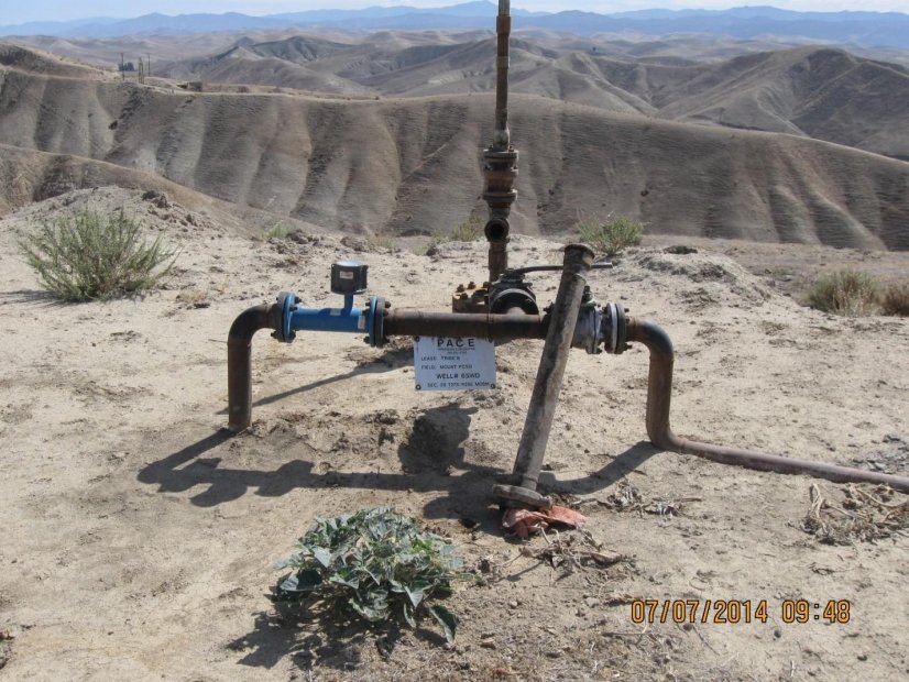
New research indicates that nearly 40 percent of new wastewater injection wells approved over the past year in California are perilously close to fault lines, increasing the risk of man-made earthquakes in the already seismically active Golden State.

The Center for Biological Diversity (CBD) found that 13 out of 33, or 39 percent, of new drill permits for wastewater disposal wells issued by regulators with California's Division of Oil, Gas, and Geothermal Resources (DOGGR) between April 2015 and March 2016 were for drill sites within 5 miles of a fault.

The CBD also found that 26 of the 33 rework permits for wastewater disposal wells granted by DOGGR over that same period were for wells within 5 miles of a fault. Rework permits are required when a company wants to re-drill a well or alter a well casing.

The CBD said it is concerned about these rework permits because alterations to an injection well can signal that a company is resuming wastewater injections, increasing the volume of water injected, or injecting in a different area underground — all actions that raise the specter of induced earthquakes.

A study released in February found that wastewater injections were likely to blame for an earthquake swarm in Kern County, California, one of the biggest oil-producing counties in the United States.

DOGGR is no stranger to controversy, of course, having previously admitted to improperly permitting as many as 2,000 wells to inject fluids from enhanced oil recovery techniques like fracking into underground aquifers that should have been protected under state and federal law.

In a letter, the CBD urged California Governor Jerry Brown to "protect Californians from oil industry-induced earthquakes by ordering your regulators to stop issuing permits for wastewater injection wells within five miles of a fault."

The letter notes that among the 26 rework permits issued was one for a Tejon oilfield well that has already been linked to induced earthquakes. That well was examined in the February study, which identified oil-waste injections as the probable cause of a series of earthquakes in 2005 near Bakersfield, CA, at least one of which was as severe as 4.7 in magnitude. The authors of the study said that "considering the numerous active faults in California, the seismogenic consequences of even a few induced cases can be devastating."
Arrow Up

5.6 magnitude earthquake strikes northeast Taiwan

Taiwan quake map
© google
The US Geological Survey revised down its original assessment of 5.9-magnitude.

An earthquake with a magnitude of 5.6 shook northeast Taiwan on Thursday (May 12), the US Geological Survey said, with tremors felt as far away as the capital, Taipei.

The quake was centred 14 km (nine miles) northeast of the coastal town of Su-ao, the U.S. Geological Survey said.

AFP reporters in Taipei said Thursday's quake rocked high-rise blocks. There were also reports by local media of power cuts and people trapped in lifts, it added.

There were no immediate reports of injuries or damage.

The USGS initially assessed it to be a 5.9-magnitude quake, before revising the figure down. It added that the earthquake was 10-kilometre below earth's surface.

Earthquakes are common in Taiwan. In February, a 6.4-magnitude quake toppled a large apartment complex in southern Taiwan killing more than 100 people. The island's worst quake disaster came in September 1999 when a 7.6-magnitude earthquake killed around 2,400 people.

Bizarro Earth

Shallow 5.5 magnitude earthquake hits Tibet

Tibet 5.5 earthquake
© USGS
A 5.5-magnitude earthquake hit Changdu in Tibet at 9:15 a.m. on Wednesday (May 11, 2016), said the China Earthquake Networks Center.

The epicenter was monitored at 31.99 degrees north latitude and 94.94 degrees east longitude, with a depth of seven kilometers.

Source: Philippines News Agency

Bizarro Earth

North American tectonic plate peeling off

Earth's Mantle
© Johan Swanepoel/ShutterstockScientists suspect that chunks from the bottom of the North American tectonic plate, which is the upper portion of the mantle, are peeling off and sinking. Replacing the resulting void is gooey material from the asthenosphere.
An odd phenomenon may explain why the Southeastern United States has experienced recent earthquakes, even though the region sits snugly in the middle of a tectonic plate and not at the edges, where all the ground-shaking action usually happens.

This seismicity — or relatively frequent earthquakes — may be the result of areas along the bottom of the North American tectonic plate peeling off, the researchers said. And this peeling motion is likely to continue, leading to more earthquakes in the future, like the 2011 magnitude-5.8 temblor that shook the nation's capital.

To figure out the cause of these earthquakes, Berk Biryol, a seismologist at UNC Chapel Hill, and colleagues created 3D images of the uppermost part of Earth's mantle, which is just below the crust and comprises the bottom of a tectonic plate. These tectonic plates scoot around atop a layer of warm, viscous fluid called the asthenosphere.

The resulting X-ray images revealed that the plate's thickness in the southeast United States was uneven, with thick regions of dense, old rock combined with thinner areas composed of younger rocks that were also less dense.

Alarm Clock

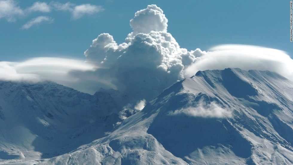
USGS: Volcano 'recharging' as earthquake swarm strikes Mount St. Helens, Washington

Mount St. Helens 2004
Mount St. Helens is a volcano in the state of Washington, seen here in 2004. It has recently been hit with a wave of small earthquakes.

In the past eight weeks, more than 130 small earthquakes have trembled beneath the surface of Mount St. Helens
. At this point, "there is absolutely no sign that it will erupt anytime soon, but the data we collect tells us that the volcano is still very much alive," the U.S. Geological Survey said.

Seismologists reported that there are no anomalous gases,and no signs that the collection of magma, which is the molten rock beneath the surface of the Earth, is getting inflated in the recent swarm of earthquakes at the volcano. Although there are no signs of an imminent eruption, the volcano is recharging, scientists say.

Mount St. Helens is in Washington state, 95 miles south of Seattle and about 55 miles northeast of Portland, OR. The earthquakes have been measured at a magnitude of 0.5 or less and the largest was at 1.3. They've been measured about 1.2 to four miles underneath the surface. With such small magnitudes and such depths, you wouldn't be able to feel the earthquakes on the surface.

But it's not the magnitude that has gotten scientists attention -- it's the frequency.

They've become increasingly common since March 14, "reaching nearly 40 located earthquakes per week," according to the USGS.

Bizarro Earth

Silent slow-slip seismic events can rupture shallow faults resulting in large, tsunami-generating earthquakes

seismic zones new zealand
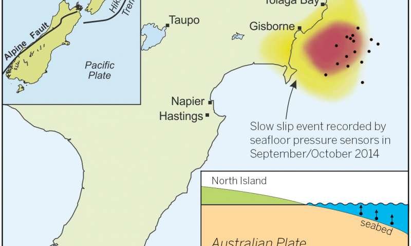
© GNS Science/Laura Martin A graphic illustrating seismic zones and activity in New Zealand. The figure on the bottom right shows the horizontal and vertical movement caused by a slow slip event
Research published in the May 6 edition of Science indicates that slow-motion earthquakes or "slow-slip events" can rupture the shallow portion of a fault that also moves in large, tsunami-generating earthquakes. The finding has important implications for assessing tsunami hazards. The discovery was made by conducting the first-ever detailed investigation of centimeter-level seafloor movement at an offshore subduction zone.

"These data have revealed the true extent of slow-motion earthquakes at an offshore subduction zone for the first time," said Laura Wallace, a research scientist at The University of Texas at Austin's Institute for Geophysics who led the study.

An international team of researchers from the U.S., Japan and New Zealand collaborated on the research. The Institute for Geophysics is a research unit of The University of Texas Jackson School of Geosciences.

The world's most devastating tsunamis are generated by earthquakes that occur near the trenches of subduction zones, places where one tectonic plate begins to dive or "subduct" beneath another. Using a network of highly sensitive seafloor pressure recorders, the team detected a slow-slip event in September 2014 off the east coast of New Zealand. The study was undertaken at the Hikurangi subduction zone, where the Pacific Plate subducts beneath New Zealand's North Island.

Bizarro Earth

Researchers believe earthquakes in SE US caused by chunks of Earth's mantle breaking off and sinking into the Earth

SE USA earthquakes
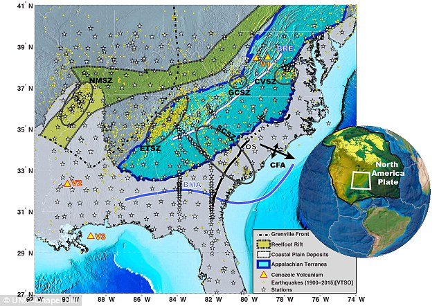
Researchers believe the quakes could be caused by pieces of the Earth's mantle breaking off and sinking into the planet in the affected area (shown here). They say pieces of the mantle have most likely been breaking off from underneath the plate since at least 65 million years ago. This map shows the study area in detail.
The southeastern United States has been hit by a series of strange unexplained quakes - most recently, the 2011 magnitude-5.8 earthquake near Mineral, Virginia that shook the nation's capital.

Researchers have been baffled, believing the areas should be relatively quiet in terms of seismic activity, as it is located in the interior of the North American Plate, far away from plate boundaries where earthquakes usually occur.

Now, they believe the quakes could be caused by pieces of the Earth's mantle breaking off and sinking into the planet.

A new study found pieces of the mantle under this region have been periodically breaking off and sinking down into the Earth. This thins and weakens the remaining plate, making it more prone to slipping that causes earthquakes.

The study authors conclude this process is ongoing and likely to produce more earthquakes in the future.

Bizarro Earth

6.1 magnitude earthquake strikes western Indonesia

Indonesia earthquake map

An earthquake measuring 6.1 on the Richter scale hit Lampung province of Sumatra Island on Monday, the meteorology and geophysics agency said here.

No immediate casualties were reported as of now, an official of the agency said.

The epicentre of the quake was determined at 23 km southwest Tanggamus town, Xinhua news agency quoted the official as saying.

Indonesia is prone to quake as it lies on a vulnerable quake-hit zone so called "the Pacific Ring of Fire".

Source: IANS