Earthquakes
S


Bizarro Earth

Montana hit by strongest earthquake in over 20 years, raising concerns that Yellowstone 'supervolcano' is slowly waking up

earthquake montana 5.9 july 2017
Following a swarm of over 1100 earthquakes recorded in the Yellowstone caldera over the past month, prompting scientists to voice concerns about a dormant Yellowstone "Supervolcano" slowly waking up, overnight these concerns escalated after a strong M5.8 earthquake hit western Montana early on Thursday morning - the strongest quake to hit the area in the past 20 years - the U.S. Geological Survey reported, with Reuters adding that the tremor was felt hundreds of miles away, from Missoula to Billings and some surrounding states.

The quake appears to be the largest to hit Montana since a slightly weaker M5.6 struck outside of Dillon a dozen years ago. By comparison, the state's largest quake which struck the West Yellowstone region 58-years ago was 7.2 magnitude.

Seismograph

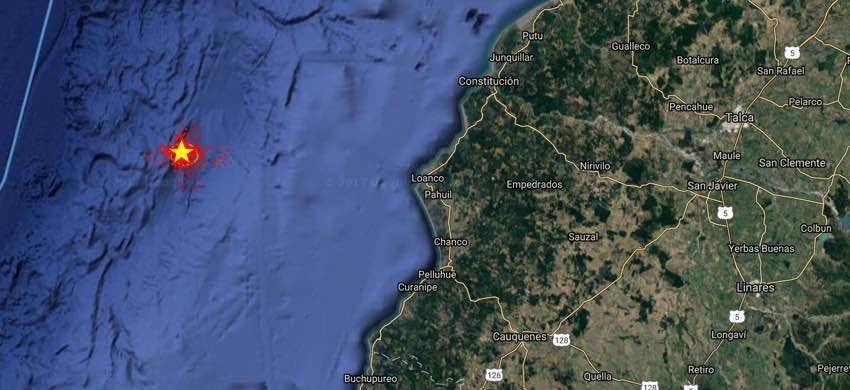
Shallow 5.9 earthquake off the coast of Chile

Star: calculated epicenter - Small red dots: possible error margin for the epicenter, the more dense, the higher probability that the epicenter will be in that area. Orange circle: epicenter location error zone
5.9 magnitude earthquake 90 km from Constitución, Maule, Chile

2017-07-04 16:05:58 UTC

USGS page: M 5.9 - 89km WSW of Constitucion, Chile
USGS status: Reviewed by a seismologist
Reports from the public: 12 people

10 km depth

Seismograph

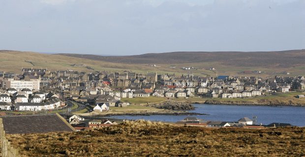
Earthquake recorded off Shetland was largest in UK for nine years

Lerwick earthquake
The epicentre was around 131 miles south-east of Lerwick and happened at 1.33pm on Friday.
A large earthquake that struck in the sea off Shetland at the weekend was the largest recorded in the UK for nine years.

The British Geological Survey said it was felt by more than 30 people more than 130 miles away from the epicentre.

The 4.4 magnitude tremor has now been upgraded to 4.7 following further analysis on the quake.

It was recorded in the northern North Sea, and the largest since a 5.2 tremor on land at Market Rasen, Lincolnshire in 2008.


The epicentre was around 131 miles south-east of Lerwick and happened at 1.33pm on Friday.

BGS seismologist Davie Galloway was in Shetland at the time and said "at least" 20 people there said they had felt it.

He said the epicentre was approximately 62 miles south-west of a magnitude 5.7 event in the Viking Graben in 1927.

The quake was felt in Lerwick and Sumburgh on Shetland; Kirkwall and Sanday in Orkney; in Wick and Thurso in Caithness and even Fraserburgh in Aberdeenshire.

One resident of Kirkwall, Orkney, said: "Very brief vibration of whole building. I am on the second upper floor."
Attention

Strong earthquake swarm at Bárðarbunga volcano in Iceland (30-June-2017)

Bárðarbunga
Bárðarbunga volcano
Today (30-June-2017) a strong earthquake swarm took place in Bárðarbunga volcano. This earthquake swarm was in the north-east area of the Bárðarbunga volcano caldera, area that has showed the most earthquake activity since this started in September-2015. Why that is the case is unclear at the moment.

Strongest earthquake in this swarm had the magnitude of 3,6 but other earthquakes where smaller, one earthquake with magnitude 3,4 and one earthquake with magnitude 3,1. All other earthquakes where smaller in magnitude. This earthquake swarm seems to be over for now, but one new earthquake took place at 22:29 and had the early magnitude of 2,7 (or 2,8).

Seismograph

Shallow 4.8 magnitude earthquake off Norway coast

norway map
4.8 magnitude earthquake 194 km from Åkrehamn, Rogaland, Norway

2017-06-30 13:33:44 UTC

USGS page: M 4.8 - 178km WSW of Utsira, Norway
USGS status: Reviewed by a seismologist
Reports from the public: 2 people

10 km depth

Seismograph

6.0 earthquake strikes off coast of Ecuador

Ecuador Earthquake
© Associated Press
A strong earthquake has struck off the coast of Ecuador, sending people running into the streets of the country's major cities. Authorities say there have been no early reports of casualties or serious damage.

The U.S. Geological Service said Friday evening's tremor had a preliminary magnitude of 6.0 and was centered about 30 kilometers (20 miles) northeast of Bahia de Caraquez. The quake occurred about 7 kilometers (6 miles) below the Earth's surface.

Shaking was felt more than 200 kilometers (124 miles) away in the port city of Quayaquil and in the capital of Quito.

The quake struck in the same region as a powerful, magnitude 7.8 temblor in April 2016 that caused nearly 700 deaths and $3 billion in damage.

Bizarro Earth

Two blasts off of Turkey's Çanakkale trigger earthquake panic

Turkey canakkale natural gas seabed leak
© Hasan Durmaz
Two natural blasts occurred around 75 meters off the coast of the Marmara province Çanakkale on June 28, prompting fear among locals that an earthquake was occurring, Doğan News Agency has reported. Footage of the incident, recorded by 47-year-old Hasan Durmaz, triggered debate among locals in Çanakkale's Ayvacık district. Geology professor Doğan Perinçek said the blasts were not signs of an earthquake, instead resulting from natural gas shooting out from the seabed.

"Today, two blasts and gas shootouts occurred in the Edremit strait, 75 meters off the coast and at a depth of 45 meters at 10:00 a.m. There was no earthquake reported. Small-size gas shootouts were previously witnessed by some locals after the Gülpınar earthquake," Perinçek wrote on his social media account.

Bizarro Earth

Big One Coming? Northern California shaken by more than a dozen earthquakes

earthquake graph image
Northern Californians were rather surprised - and perhaps a little unnerved - when more than a dozen earthquakes shook the Sierra region in a single morning. At least 16 earthquakes were registered near the town of Truckee in Northern California, about 200 miles northeast of San Francisco. According to the US Geological Survey (USGS), the first temblor hit the area at about 2:00 a.m., while the strongest shake had a magnitude of 3.9.

"I literally felt a wave under the bed, and I sat straight up," one resident told CBS.

A group of UC Berkeley seismologists says that heavy rain and snow this winter has contributed to the earthquakes, which were centered in the Sierra mountains. They say the excessive mass of water and snow puts enough pressure on the mountains to make them move and flex as the water begins to run off and dry out, triggering the earthquakes. "These stress changes are just giving it that push over the edge, and makes these faults rupture earlier," said Christopher Johnson, a researcher at Berkeley's Seismology Lab.

Seismograph

USGS: Strong and shallow M6.0 earthquake hits off Raoul Island, New Zealand

Raoul Island earthquake
© USGS


Magnitude
6.0 mww

Depth 10.0 km

Time 2017-06-28 18:20:53.900 (UTC)

Bizarro Earth

There have been four earthquakes in Maine so far this week

earthquakes Bangor ME
Geologists say there have been four earthquakes recorded in Maine so far this week, according to Portland ABC television affiliate WMTW. That brings this month's total to five, more than double the monthly average for Maine over the past year. All four this week have been very minor quakes, with three of the four — two at a 1.4 on the moment magnitude scale and one 1.7-magnitude near Lincoln — taking place Sunday, WMTW reported.

The fourth, at a magnitude of 1.3, was recorded near Livermore around 1 a.m. Wednesday, according to the station. According to Michigan Technological University, earthquakes under 2.5 in magnitude are "usually not felt, but can be recorded by a seismograph," and about 900,000 such quakes are estimated to take place around the world every year.

Earlier this month, residents of Monroe took to social media to report feeling the ground shake in what was recorded as a 2.1-magnitude earthquake there.