Earth ChangesS

Boat

5.9 magnitude earthquake hits south of Bambanglipuro, Indonesia

Image
© Google
The earthquake, which struck at about 6:45 p.m. local time, was centered about 107 kilometers (66 miles) south of Bambanglipuro, or 129 kilometers south of Yogyakarta, according to the United States Geological Survey (USGS). It struck about 95 kilometers (59 miles) below the sea floor, making it a relatively deep earthquake.

"All my neighbors come out from their houses," one resident in Bantui said.

No tsunami alerts were issued after Wednesday's earthquake, and there was no immediate word on damage or casualties.

Other details are not yet available.

Attention

Orange alert issued in Guatemala following eruption of Fuego volcano

Image
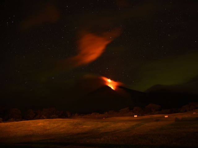
© AFPThe Fuego volcano, seen from San Juan Alotenango municipality, Sacatepequez departament, about 65 km southwest of Guatemala City, erupts on November 10, 2015.
Emergency service officials in Guatemala on Tuesday issued an orange alert over increasing eruptions from the country's southeastern Fuego volcano and ordered the evacuation of a nearby hotel.

The 12,346-foot high colossus, whose name means "fire" in Spanish , showed heightened activity overnight, sending columns of ash high into the sky, spilling lava down its side and provoking small tremors.

Fine ash was falling on at least six villages and on the town of San Pedro Yepocapa, in the indigenous province of Chimaltenango, a state spokesman for the Disaster Reduction National Coordination Committee, David de Leon, told reporters.

The country's Seismology and Vulcanology Institute urged authorities to consider taking precautionary measures for air traffic.

Thick, airborne ash can clog planes' engines and cause them to fail. In February, the volcano erupted with such force and so much ash that Guatemala was forced to close the airport serving its capital.

Guatemala and neighboring countries lie on what is known as the Central American Volcanic Arc, a chain of hundreds of volcanoes that forms part of the Pacific "Rim of Fire". Most are dormant, but some spectacular, and dangerous, eruptions do happen.

The Fuego volcano lies near Guatemala's colonial-era city of Antigua Guatemala and is about 40 kilometers southwest of the capital Guatemala City.

Comment: Video footage from someone on site in Antigua, Guatemala:


Arrow Up

Mexico's Colima volcano has another double eruption

Image
© IBTimes
Less than a week after a pair of eruptions, Mexicos Colima or Fire volcano pulled of the feat again on Tuesday (10 November) morning, as its period of activity continues.

According to officials, the first eruption occurred at 7.03am local time, sending a column of ash and smoke some 2,500m into the sky. National Civil Protection coordinator Luis Felipe Puente said on his Twitter account that ash and smoke rose 2,000m above the crater of the volcano during the second explosion, which occurred at 9.02am local time.

Located in the south-western Mexican state of Colima, the Fire Volcano has been exhibiting continuous activity since 9 July. Over the past months, nearby villages have been blanketed with thick coats of ash, prompting evacuations.

Officially known as the Colima Volcano, it was previously active in January and February and is part of the Pacifics Ring of Fire. Mexico contains over 3,000 volcanoes but only 14 are considered active.


Comment: Mexico's Colima volcano explodes five times in one morning


Bizarro Earth

Massive ancient underground river system discovered in once-vibrant Western Sahara

Image
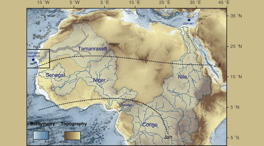
© Nature CommunicationsMap of the main rivers of the Mediterranean, West African Tropical and Equatorial margins and associated watersheds.
A riveting mystery is unfolding in Western Sahara, as scientists discover a massive ancient underground river system with the aid of satellite imaging. It confirms that only about 5,000 years ago, the Sahara was an immensely vibrant place.

The African region containing the Mauritanian Desert is roughly the size of the United States - or a quarter of Africa; so if such conditions persisted today, the river system would be the world's 12th-largest, French-led research indicates in the journal Nature Communications.

Cloud Precipitation

Rivers of hail run through the desert after freak storm in Iraq

Image
© Live LeakDisbelief: A man wearing an ankle-length thwab, which helps him to keep cool, picks up the hail
It's known for its hot, dry summers and short, cool winters but not this year as Iraq was hit by a torrential rain and ice storm which led to meltdown in the war-torn country.

This incredible footage shows the extent of an unprecedented weather pattern that's caused chaos in the Middle East.

A frozen river of ice water is seen raging through the desert as these Iraqi men watch on in disbelief.

The region - renowned for its arid climate - has been hit by ice storms, strong winds and heavy rain in recent days leading to the Iraqi government declaring a state of emergency.


Arrow Down

Vehicle falls into sinkhole in central Florida

WPTV YouReporter Shelley Jaggernauth sent in photos of a sinkhole swallowing a vehicle at a repair shop in central Florida.

Shelley said her brother was working at Indy's Auto Center when he and a co-worker heard a sound similar to a car door closing. She says they looked out front and saw this:

Image
According to Shelley, an attempt was made to remove the vehicle from the hole using a standard tow truck, but they had to call in a larger truck from a company that tows "semi" trucks.

No one was injured.

Shelley's brother says the hole was approximately 18 feet deep.


Ice Cube

Enormous icebergs break off from Svinafellsjokull glacier in Iceland

Iceland iceberg
© Olen Adventures / YouTube
A video of enormous chunks of ancient ice covered in dark volcanic ash breaking off from a glacier, captured by a tourist in Iceland, has taken YouTube by storm.

Don Olen and his wife were on a trip to Svinafellsjokull Glacier when they shot the stunning clip. They were away from their group when they heard noises that sounded like an iceberg starting to break up.

Tornado1

Yemen sees unprecedented Cyclone double-whammy, 14 killed on Socotra island

damaged house after Cyclone Megh
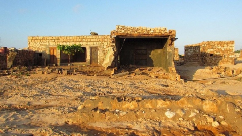
© ReutersA damaged house is pictured in a village deserted after Cyclone Megh struck it on Yemen's Socotra island.

This is the second cyclone to hit the war-torn country in a week


Cyclone Megh has killed 14 people on war-ravaged Yemen's Socotra island, the second rare tropical storm to hit the Arabian Peninsula country in a week, officials said.

Two women and two children were among the 14 people who died on the island, around 350 km off Yemen's mainland. Dozens more were injured.

The UN's humanitarian agency OCHA said Megh appeared to be getting weaker as it made landfall on Yemen's coast early onTuesday.

"A thousand houses collapsed and some 2,000 others were damaged" on Socotra, and hundreds of fishing boats were damaged and many livestock animals killed, officials said.

Heavy rain and strong winds also took Socotra's port out of service and caused extensive damage to the island's roads, 80 percent of which became impassable.

Comment: Less than a week ago Cyclone Chapala struck Yemen, the first ever cyclone (hurricane) to make landfall on the Arabian peninsula. We are observing increasingly chaotic and 'extraordinary' weather events all over the planet these days. See SOTT's Earth Changes video summary for September below.


SOTT Earth Changes Summary - September 2015: Extreme Weather, Planetary Upheaval, Meteor Fireballs


Bizarro Earth

Strong earthquake recorded off La Serena in Northern Chile

Chile Earthquake
© USGS
A strong earthquake with a preliminary magnitude of 6.9 has struck off the coast of northern Chile, seismologists say.

The earthquake, which struck at 10:54 p.m. local time on Tuesday, was centered in the ocean about 94 kilometers (58 miles) west of La Higuera, or 101 kilometers (63 miles) northwest of Coquimbo, according to Chile's seismological service. It struck about 32 kilometer (19 miles) below the ocean floor, making it a shallow earthquake.

The Pacific Tsunami Warning Center, which also measured the earthquake at 6.9, said there was no threat of a Pacific-wide tsunami, and Chile's Hydrographical and Oceanographical Service of the Navy (SHOA) confirmed that no tsunami alerts had been issued.

Strong shaking was felt in coastal regions, witnesses said, but there were no immediate reports of damage or casualties, said Chile's National Office of Emergency of the Interior Ministry (ONEMI).

Other details were not immediately available.

X

Earthquake measuring 6.6 magnitude strikes off coast of Chile

Image
© USGS
A 6.6 magnitude earthquake has struck off the coast of Chile, some 110 kilometers west of Coquimbo, according to USGS.

The epicenter of the quake was located at a depth of 38 kilometers (23.6 miles).

The Pacific Tsunami Warning Center said that based on all available data they have received; there is no threat of a tsunami striking Hawaii.

There were no immediate reports of any injuries or damage having occurred to local buildings.

The quake affected the same region as the deadly 8.3-magnitude earthquake in September, which killed at least 15 and forced over one million people to evacuate their homes, triggering tsunami warnings in California and Hawaii.

Chile has a long history of major quakes, including the strongest recorded in recent history. At least 1,655 people were killed and 3,000 injured in the Great Chilean Earthquake of 1960.

Comment: 6.3 Quake rocks northern Chile, causes panic among residents