Earth ChangesS


Attention

Green alert issued as Turrialba Volcano ashfall intensifies in Costa Rica

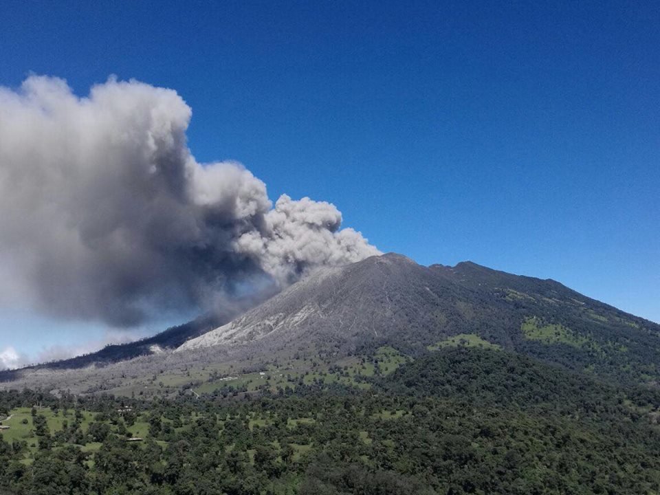
Turrialba Volcano continues to send ash towards the Central Valley in a series of prolonged eruptions beginning Dec. 28.
© Blas Sánchez/CNETurrialba Volcano continues to send ash towards the Central Valley in a series of prolonged eruptions beginning Dec. 28.
The National Emergency Commission (CNE) declared a Green Alert for the Central Valley on Thursday afternoon as Turrialba Volcano continued to pump ash intothe skies in the latest of the constant eruptions that have lasted throughout the past two weeks.

A statement from Casa Presidencial indicated that a combination of continued eruptions, a dry air system over Central America that has reduced the chance of rain, and strong winds have all contributed to the increase of ashfall in the area.

The CNE asks municipal emergency commissions to be vigilant, keep their communities informed and monitor ash levels. If people have to leave their houses in areas where significant ash is present, the government recommends that they cover their mouths and noses with towels or dust masks. The CNE also suggests not consuming food outdoors and to even avoid driving in areas with high ash levels.

On Thursday morning, the National University's Volcanological and Seismological Observatory of Costa Rica (OVSICORI) reported more ashfall being carried by southwest winds towards the San José metro area. Ash was seen covering cars and buildings Wednesday throughout the capital and the broader Central Valley, including as far north as Heredia and as far west as Escazú.
Attention

Bogoslof Volcano in the Aleutians back at Red Alert

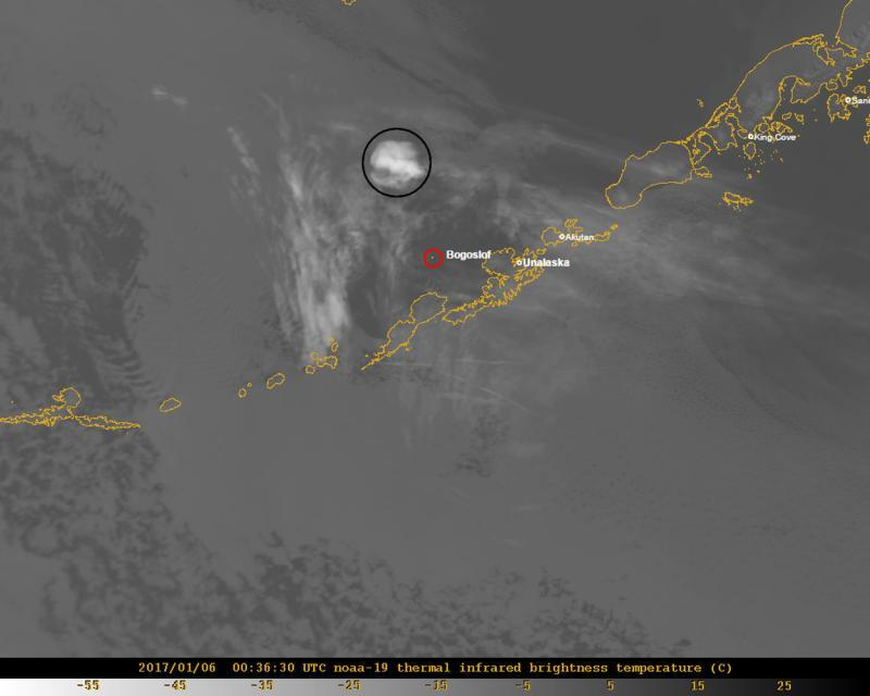
 A satellite image showing the volcanic cloud from Bogoslof's January 5, 2017 eruption.
© Dave Schneider, AVO/USGS
A satellite image showing the volcanic cloud from Bogoslof's January 5, 2017 eruption.
Two hours after lowering the aviation code for an Eastern Aleutian volcano, it's back at the highest alert level.

The reasoning? According to the Alaska Volcano Observatory, there was a significant explosion at Bogoslof volcano Thursday afternoon.

The observatory detected a raised level of seismicity around 1:30 p.m. as well as reports from the World Wide Lightning Detection Network of lightning strikes. A pilot reported seeing a volcanic cloud at 35,000 ft.

The volcano has been erupting since mid-December.

Cloud Precipitation

Deadly floods strike south Thailand for second time in a month; foot of rainfall in a day

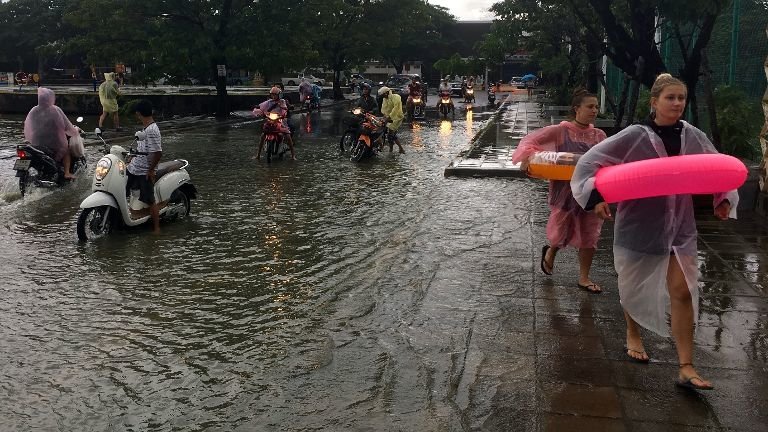
Tourists wear flotation devices and moped riders pause before crossing a flooded roadway on Ko Samui, Thailand Thursday, Jan. 5, 2017.
© AP/Adam SchreckTourists wear flotation devices and moped riders pause before crossing a flooded roadway on Ko Samui, Thailand Thursday, Jan. 5, 2017.
Flooding has affected at least 8 provinces in the south of Thailand. Thousands have been affected and at least 6 people have died.

The rains - unusually heavy for this time of year - have been falling since around 31 December, 2016. Nakhon Si Thammarat recorded more than 300 mm in one day. Forecasts say that more rain is expected over the coming 48 hours.

This is the second deadly flood event within a month in south Thailand. At least 11 people died and 350,000 were affected after flooding struck southern provinces in December 2016.

Thailand's The Department of Disaster Prevention and Mitigation (DDPM) is preparing to provide assistance to the thousands of victims currently affected by flooding in the southern provinces.


Snowflake

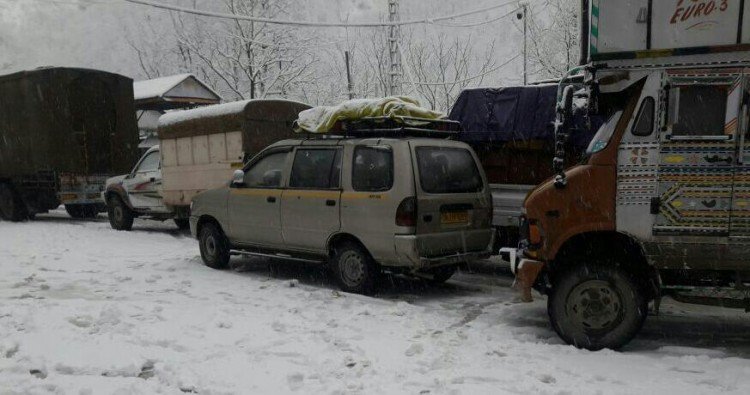
Major Jammu-Srinagar highway in India shut for fourth consecutive day due to heavy snowfall

Jammu-Srinagar highway closed due to heavy snowfall.
In Kashmir Valley, snowfall continued for the fourth consecutive day and Met office predicted more wet weather over the next few days.

Most of the flights were cancelled at Srinagar International Airport due to poor visibility. The snowfall also hit operations on the runway, an airport official said.
Jammu and Kashmir: Kashmir valley receives snowfall pic.twitter.com/XAcTJgyBPA

— ANI (@ANI_news) January 6, 2017
The depth of snow in Gulmarg, a star attraction for tourists during the winter, was two feet. The health resort of Pahalgam, which serves as a base camp for the Amarnath Yatra, received 3.5 cm of snow and was chilling at minus 1.6C.


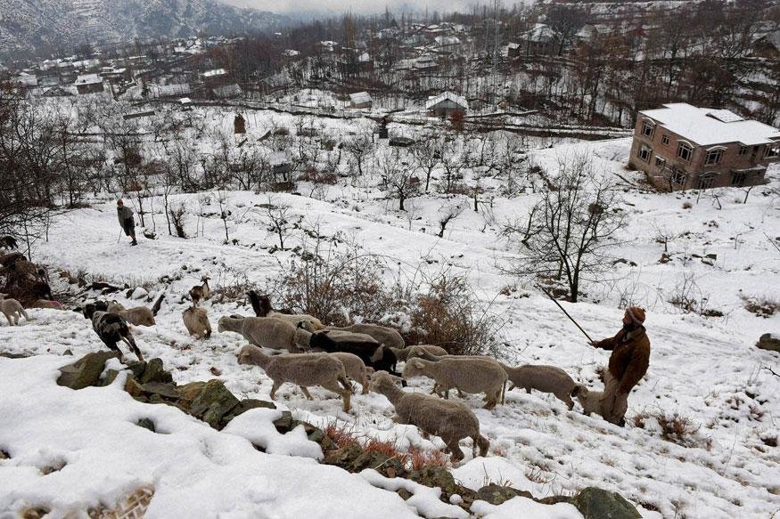
A shepherd at a snow-clad field during light snowfall on the outskirts of Srinagar on 5th January, 2016.
© PTIA shepherd at a snow-clad field during light snowfall on the outskirts of Srinagar on 5th January, 2016.

Seismograph

Shallow 5.3 earthquake shakes Central New Zealand

GRAPH
People in Central New Zealand woke up to a severe earthquake of magnitude 5.3. The quake which rattled the country once again within a span of ten days was felt by thousands of citizens.

As per Geonet, the quake struck 20km southwest of Seddon in Marlborough at around 12:17 am early Friday. The earthquake was just 13km deep and was widely felt.

So far reports of any injuries or damages have not been reported though the quake was felt by more than 6300 people from Auckland to Invercargill. The lower half of the North Island and top of the South Island is said to have felt more aftershocks.The quake has been described as a short, fierce quake and it trembled homes overnight and set hearts battling.

USGS data

Seismograph

Magnitude 5.1 earthquake takes 4 lives in southern Iran

GRAPH
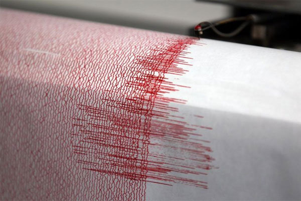
An earthquake measuring 5.1 on the Richter scale hit Khonj city in southern Iranian province of Fars leaving four people dead.

Managing Director of Crisis Management Center at Provincial Governor's Office of Fars Province Hassan Fayazpour said the earthquake had struck four villages in Khonj region at 06:30 local time.

The official, while noting that the epicenter of the quake was in an area at longitude of 53.18 and latitude of 28.11, said the earth tremor was first believed to have only left financial losses though deployment of rescue teams reveled that four people had been killed.

USGS data

Snowflake Cold

Winter Storm Helena Heads East, Killing 2; State of Emergency Declared in Alabama, Georgia

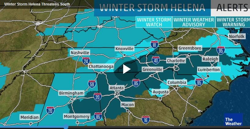
Winter Storm Helena
© The Weather Channel
The rush was on as millions in the Deep South began preparations Thursday for Helena, a dangerous, deadly winter storm that could cause serious problems across the region over the weekend.

Alabama Gov. Robert Bentley announced Thursday afternoon that a state of emergency will take effect Friday morning at 7 a.m. CST. The declaration affects all counties in the state, and among the impacts of the state of emergency is the activation of 300 soldiers from the Alabama National Guard to assist mission support teams and command staff.

Georgia Gov. Nathan Deal also declared a state of emergency, which was set to begin at noon on Friday.

On Thursday, the Georgia Emergency Management Agency warned North Georgia residents to prepare for the winter storm and urged people to have enough food and other supplies on hand to stay in their homes for three days. Several school districts in metro Atlanta will dismiss students early on Friday.

The Georgia Department of Transportation began working days ahead of the storm to make sure they are ready when wintry weather moves into central and north Georgia, including metro Atlanta, Friday night into Saturday, reports WALB.com.

"In the metro area, we have 10 5,000-gallon tanker trucks to treat the interstate," GDOT Maintenance Engineer Dale Bradley said.

Pre-treating roads with brine is a new tactic for GDOT since Winter Storm Leon crippled the city and left drivers stranded on area roads in January 2014.

"We are trying to pre-treat before the storm, but at the same time close enough to the storm that if it does come in as heavy rain, we don't get a lot of it washed off," Bradley said.

Into the Carolinas, residents began to stock up on food and other supplies with even bigger snow totals in the forecast.

Comment: 10-15 feet of snow to bury California: Wintry weather also targets South


Rose

Flowers blooming early in UK and India

Daffodil blooms to flower in middle winter UK 2017
© SolentThe flowers do not usually start appearing until February
Photographer Ian Scammell, 41, spotted them as he drove to a friend's house on New Year's Eve.

About 30 of the early bloomers are clustered on a grassy bank by a road in Ramsgate, Kent.

The flowers, which do not usually start appearing until February, have been fooled into blooming a month early by this winter's unusually mild weather in the South.

Comment: See also:


Binoculars

Rare waxwing birds from abroad that signal harsh winter seen across Gloucestershire, UK as temperatures plummet

Waxwing
Waxwing
Delighted twitchers came out in force after groups of rare birds said to be a sign of a harsh winter descended on the county in search of berries this week.

Groups of waxwings have been spotted across the county in recent days.

Crowds or birdspotters have been gathering around sites where the feathered winter visitors have arrived from colder climes looking for food.

At the minute many are gathered at Lidl in Cinderford where around 16 Waxwings have been spotted feeding from the winter berries.

Two waxwings have been spotted feeding on berries outside the police station in Cirencester and a pair have been seen at the The Boars Head car park in Berkeley.


Snowflake Cold

10-15 feet of snow to bury California: Wintry weather also targets South

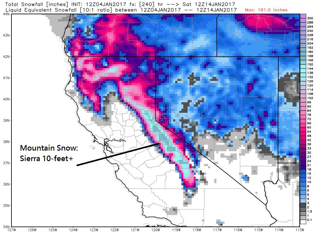
Winter storm map
© Ryan Maue / Twitter
A series of winter storms is forecast to continue hammering California with several feet of heavy snow and driving rain over the next few days and into the weekend, good news for the drought-plagued state and for ski areas, but potentially bad news for travelers and homeowners worried about floods and mudslides.

Meanwhile, a storm could also spread a stripe of snow across the South, all the way from Texas to Virginia, from late Thursday into Saturday.

In the West, "the combination of storms through this weekend has the potential to bring the biggest amount of rain and mountain snow to California since the drought began several years ago," according to AccuWeather meteorologist Jim Andrews.