Secret HistoryS

NPC

Mad Science: The history of misguided attempts to geoengineer Earth

earth
Harvard's Gernot Wagner wants to save the world from global warming. His method? Develop a new type of plane that will fly more than 4,000 missions a year dumping particulates into the stratosphere.

Wagner and his colleague Wake Smith call the proposed plane "SAI Lofter (SAIL)." Anonymous individuals at "Airbus, Atlas Air, Boeing, Bombardier, GE Engines, Gulfstream, Lockheed Martin, NASA, Near Space Corporation, Northrup Grumman, Rolls Royce Engines, Scaled Composites, The Spaceship Company, and Virgin Orbit" provided input.

Estimates for SAIL's design and operation seem sophisticated but are fabricated. Wagner and Smith admit, "No existing aircraft design-even with extensive modifications-can reasonably fulfill [their] mission."

Bizarro Earth

The last megaquake that rocked the Pacific Northwest

Cascadia Subduction Zone
© American Geoscience InstituteScreenshot of a graphic showing the Cascadia Subduction Zone.
Red cedar "ghost forests," a Japanese villager's handwritten notes, and Native American oral histories: They all offered clues that led scientists to precisely date the last megaquake that rocked the Pacific Northwest.

It occurred on Jan. 26, 1700.

Unraveling the clues was similar to being a detective investigating a "not-so-ancient geological crime," U.S. Geological Survey scientist Brian Atwater said during a presentation to a full house at LCC's Health and Science lecture hall Wednesday night.

But "there's an edge to this story," he said. "It's a frightening thing. ... The effects of the tsunami are not so pretty."

That is because the next quake could come at any time, though they recur on average every 500 years or so. But the intervals are highly variable, and researchers estimate that there's a 10 percent chance the region will be hit with the next magnitude 8 or larger earthquake within the next 50 years.

Whenever it occurs, it will shake the ground for several minutes from Vancouver Island to Northern California and churn up tsunamis that swamp coastal communities. Thousands may die, and the region's highway and utility infrastructure and thousands of buildings will collapse, geologists say.

Atwater is a pioneer whose research helped determine that giant "subduction zone" earthquakes have occurred in the Pacific Northwest in the past and will do so again.

Bad Guys

Why do they hate us? Why the West should stop its Middle East interventions

sdf civilians syria
© REUTERS/Rodi SaidA large influx of civilians released from Baghouz through a corridor opened by
SDF February 20, 2019.
In 2003, when the US declared its occupation of Iraq, journalists used to reach the country embedded with the occupation forces through their air transport or via Kuwait. I did not have this luxury. I took a taxi from Beirut to Damascus and from the Syrian capital to Baghdad. It was a long drive, and I had no information on how to travel alone in a new country I had never visited before, but that in itself was not a new experience for me.

It was my first time in Iraq but I never imagined I was about to spend the next nine years in the country. I reached the al-Tanf border crossing, and waved goodbye to the final Syrian checkpoint behind me. Al-Tanf became my favourite destination for years to come until, years later, Baghdad (and Mosul) airport started civilian flights from and to Iraq. I was oblivious to the fact that this desert signpost, over 100 km from the nearest gasoline station, would someday become known worldwide due to US occupation of this crossing in 2017.

The borders on the Iraqi side were empty: unusually, no visa was required nor was anyone present to ask for it. No border guards were there on the Iraqi side. The first few kilometres in Iraq were punctuated by craters a couple of meters deep caused by the US bombing; this made driving quite acrobatic but possible for skillful drivers. The high fares taxi drivers asked for the ride seemed quite understandable.

Life in Baghdad in 2003 was not very difficult for a war zone journalist with experience in besieged cities like Beirut in 1982 or Sarajevo, the Bosnian capital, under tight siege in 1993-1994 (it became less difficult in following years). Seasonal vegetables and fruits were not lacking, although nothing was exported except for bananas. Talking to people was easy but communication systems and internet contact with the outside world were absent and only possible via Thuraya satellite phone or similar means. The language was a barrier at first, but with time I learned to understand and then speak the local Arabic dialect, which is different from the Levantine dialect familiar to me from the many years I spent covering other wars.

Comment: See Magnier's previous parts in this series here: Reshaping the Middle East: Why the West should stop its interventions


Dig

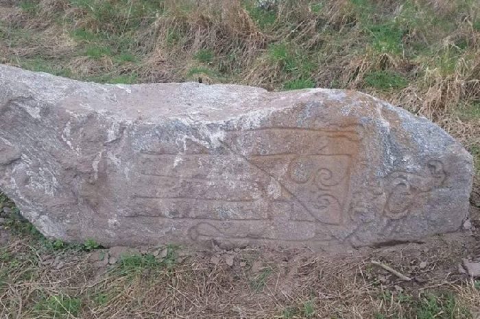
6ft "Pictish stone" with eagle symbol discovered in north of Scotland

Pictish stone
© Wayne Miles/Pictish Arts Society.The stone, which was found on a building site on the outskirts of Elgin, could be Pictish in origin.
A new Pictish stone may have been found on a building site in the north of Scotland.

The monument was discovered by amateur metal detectorist Wayne Miles on the site of a new business park outside Elgin, Moray.

The stone, which is around 6ft tall and estimated to weigh around two tonnes, is similar in design to the Dandaleith Stone which was found at Craigellachie, around 13 miles south of Elgin, in 2013.

Both are decorated with a notched rectangle design and eagle symbol.

Comment: As noted in 1,000-year-old Pictish fort unearthed in Scotland:
Almost nothing survives of the mysterious Pictish culture, including the name they called themselves. The Romans first mentioned the Picts, which means "painted people," likely because of their distinctive tattoos and war paint. However, relatively few Pictish writings survive, and much of what historians know about the Picts' early history comes from the accounts of Roman speechwriters such as Eumenius.
The following article from the BBC provides some examples of how these Pictish stones may have looked with colour:
Scotland's carved Pictish stones re-imagined in colour

Knocknagael Boar Stone
© Historic Environment RecordAn illustration of Inverness' Knocknagael Boar Stone
Archaeologists have been uncovering ornately decorated Pictish stones across northern Scotland for many years.

For many, the sculptures' mysterious carvings of animals and symbols are impressive as they are.

But some scholars suggest their ancient creators may also have painted the stones, bringing out in vivid colours their carved salmon, ravens, wolves, boars and even a battle scene.

Pictish stones
© UHI Archaeology InstitutePictish stones continue to be discovered including this one on Orkney
Working with experts, Historic Environment Scotland (HES) has created new interpretation panels for some of the best-known Pictish stones.

Archaeologists and historians have long debated the origins and activities of the Picts, HES says the idea they painted their carved stones is speculative.

Many academics agree the Picts were descended from indigenous Iron Age people of northern Scotland, and the term "Picti" was likely to have been a nickname the Romans used to describe communities north of Hadrian's Wall.
Aberlemno
© Historic Environment ScotlandAberlemno's battle stone
The Picts created intricately decorated standing stones and also constructed impressive hill forts to defend themselves against rival tribes and invaders.

They battled against the Romans, Angles and the Vikings.

To add colour to their carved stones they would have used minerals and plants to make their paints, says HES.
Pictish
© ACASAnother example of a new-found Pictish carved stone
But sculptures found so far have stood outside for more than 1,000 years so any pigment is likely to have been "scrubbed away" by long exposure to the effects of the sun, rain and wind.

However, there is evidence the Picts used colour on other objects, including metalwork.

Pigment has also survived on other relics elsewhere at the time of the Picts.

These include on stonework from Northumbria and Mercia, while colour is a strong a feature of early Christian manuscripts such as the Book of Durrow and the Book of Kells.

Bannocks challenge

Added to that were the Romans, who used colour on their sculptures and were a "significant cultural influence" on the Picts.

"The hypothesis is supported by many Pictish scholars as probable or the very at least possible," said HES.

"We drew on their advice throughout this project."
Maiden Stone
© Historic Environment RecordAn illustration of how The Maiden Stone in Aberdeenshire may have looked with colour
Stones with the new interpretation panels include one at Aberlemno in Angus.

It is believed to show the Battle of Dun Nechtain, in or around 685AD, which saw a Pictish army defeat invaders from Northumbria.

Also, the Dunfallandy Stone in Pitlochry, Perthshire.
dyce pict
© Historic Environment ScotlandOne of the new interpretation panels created by HES
Another is the Maiden Stone in Aberdeenshire.It was carved more than 1,200 years ago.

Legends attached to the stone include one that purports the stone is actually a woman who was turned stone after losing a wager with the Devil that she could bake bannocks faster than he could build a road to Mither Tap, a summit on the hill Bennachie near Inverurie.

Dragon-like carving

Inverness' Knocknagael Boar Stone was carved more than 1,400 years ago.

It has been in the care of Highland Council for many years after it was damaged by bad weather and vandals.

It is on display at the local authority's headquarters in Inverness.

Pictish stones are still being uncovered today, including one with a dragon-like carving in Orkney and another near Craigellachie in Moray.
Dunfallandy
© Historic Environment ScotlandThe Dunfallandy Stone stands near Pitlochry in Highland Perthshire
See also: And check out SOTT radio's: Behind the Headlines: Who was Jesus? Examining the evidence that Christ may in fact have been Caesar!


Bad Guys

How Britain forcefully depopulated an entire archipelago - then covered it up

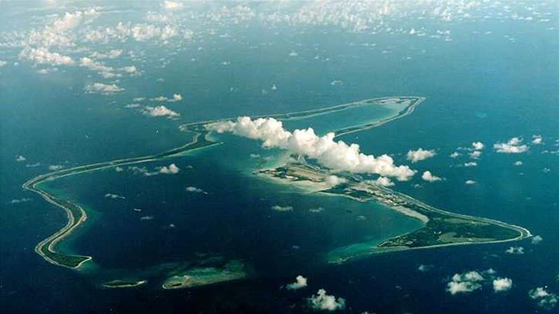
Chagos archipelago
© ReutersDiego Garcia, the largest island in the Chagos archipelago in the Indian Ocean, is the site of a major US military base and was leased from Britain in 1966
There are times when one tragedy tells us how a whole system works behind its democratic facade and helps us understand how much of the world is run for the benefit of the powerful and how governments often justify their actions with lies.

In the late 1960s and early 1970s, the British government of Harold Wilson expelled the population of the Chagos Islands, a British colony in the Indian Ocean, to make way for an American military base on Diego Garcia, the largest island. In high secrecy, the Americans offered the British payment for the islands in the form of a discount on the Polaris nuclear submarine system.

The truth of this conspiracy did not emerge for another 20 years when secret official files were unearthed at the Public Record Office in London by lawyers acting for the former inhabitants of the coral archipelago. Historian Mark Curtis described the enforced depopulation in Web of Deceit, his 2003 book about Britain's post-war foreign policy.

Info

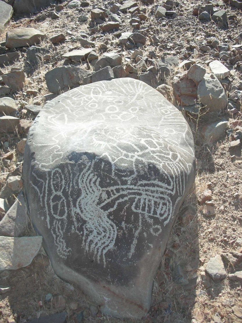
Chilean petroglyphs may have been used for star-gazing

engraved stones
© BERNARDI, ET ALOne of the engraved stones on the elevated site at La Silla, thought to be part of an ancient star-observing platform.
The complex astronomical measurements that underpinned many aspects of the Inca civilisation may have an ancient forerunner of 10 centuries earlier and 2000 kilometres distant, a prominent archeoastronomer suggests.

Steven Gullberg, of the University of Oklahoma, US, and chair of the International Astronomical Union Working Group for Archaeoastronomy and Astronomy in Culture, is the latest scientist to comment on the origin and purpose of some mysterious stones and engravings, known as petroglyphs, at a site known as La Silla, in Chile.

The complex designs etched in rock, together with a set of standing stones, were first studied in depth by researchers - including this writer - in 2012.

It was suggested that the artefacts were set up to mark the positions of two very brilliant stars, Canopus and Hadar, and were the work of the El Molle, a pre-Columbian culture that occupied the region for five centuries from about 300 CE.

Curiously, La Silla is today the site of a facility built and operated by the European Southern Observatory (ESO), an important part of the global infrastructure for astronomers.

If the tentative conclusions about the petroglyphs and standing stones are correct, the site has been a critical place for star-gazers for at least 1700 years.

Info

Disagreement erupts over Neanderthal posture

Neanderthal Posture
© 4x6/Getty ImagesThe image of Neanderthals as hunched ape-men was dispelled decades ago, but some scientists fear recent research might go some way towards reviving it.
Recent spinal reconstructions have focussed debate on Neanderthal posture and, by implication, whether standing fully upright is the sole preserve of Homo sapiens.

Gone are the depictions of Neanderthals as hulking imbeciles. But echoes of prejudices against our prehistoric cousins persist in analyses of Neanderthal remains, according to the authors of a new spinal reconstruction of La Chapelle-aux-Saint 1, arguably the most famous Neanderthal fossil to have been unearthed.

The new reconstruction, which appears in the Proceedings of the National Academy of Sciences, takes in the spinal vertebrae, as well as the pelvis and a cast of the right hip bone. The actual hip bone is missing, misplaced sometime in the 1970s.

Measurements of the angle of the pelvis in relation to the spine and how the vertebrae stack one atop the other suggest that the Neanderthal spine was curved much like our own - sweeping inwards from the lower back towards the waist.

"The posture of the Neanderthals is very human-like," says Martin Hรคusler from the University of Zurich, Switzerland, who led the study.

Doberman

Prehistoric Siberians may have traveled 1,500 kilometers by dogsled

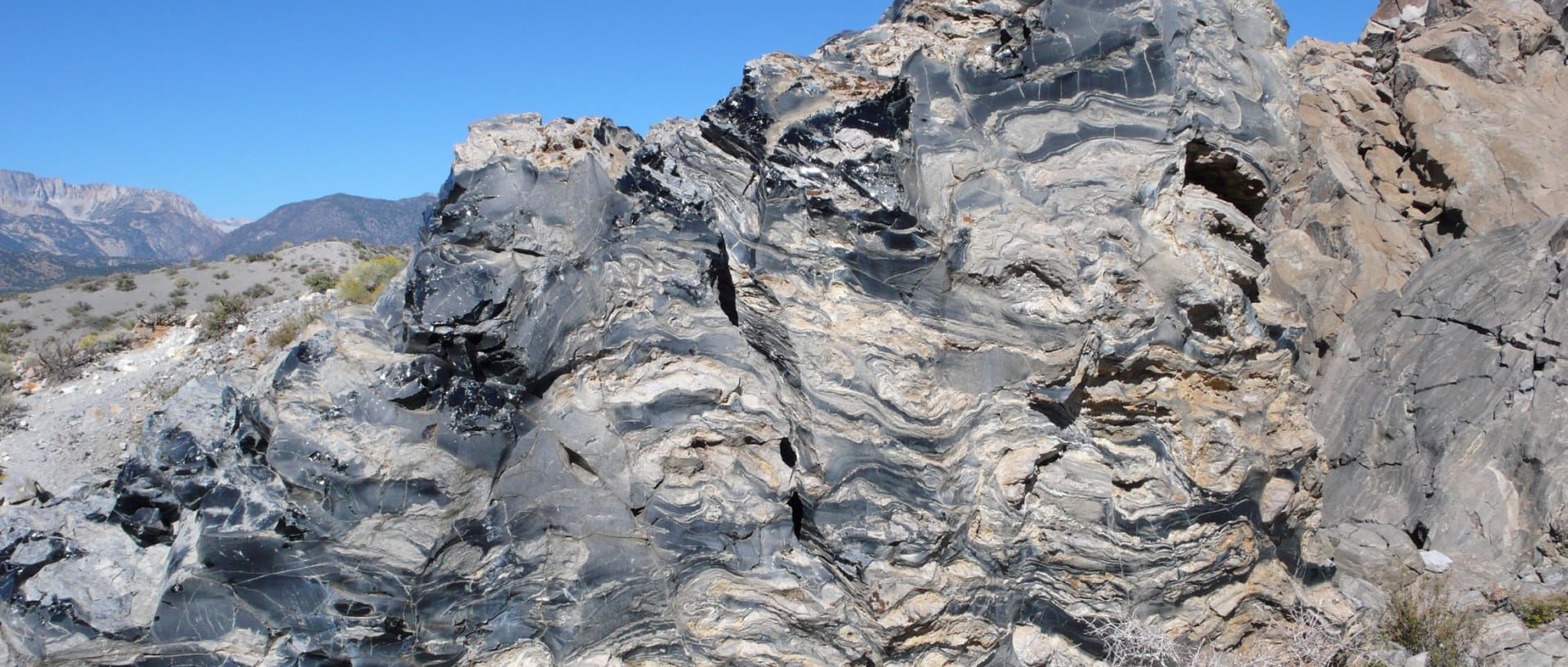
obsidian
© USGSFlow banding of light pumice and glassy black obsidian, which is created when hot lava smashes into water and cools on the spot
The discovery of obsidian tools on Zhokhov island indicates the existence of a vast trading network in prehistoric deep Arctic 9,000 years ago.

Prehistoric Siberians living on an island in the Arctic Circle around 8,000 to 9,000 years ago possessed obsidian tools that hailed from 1,500 kilometers (932 miles) away, Russian archaeologists reported in the journal Antiquity last week.

To people living on icy Zhokhov Island, the closest known source of obsidian - a shiny glassine volcanic rock that shatters to create extremely sharp blades - is near Lake Krasnoye in the lower reaches of the Anadyr River in Chukotka.

Krasnoye is 1,500 kilometers as the bird flies from Zhokhov. As the sled dog trudges, it's more like 2,000 kilometers, the team headed by Vladimir Pitulko of the Russian Academy of Sciences reports.

Comment: See also:


Blackbox

Best of the Web: Alternative History of Al-Qaeda: Anwar al-Awlaki - jihadist, spy, or both?

Awlaki
Just another coincidence... Senior Al Qaeda leader Anwar Al Awlaki was clicking glasses together at the Pentagon with American military brass just months after the 9/11 attacks in 2001. Also, "coincidentally," he had in fact met at least one of the several alleged hijackers. He also, just before being liquidated by a US drone attack in 2011, allegedly funded the terror cell responsible for the recent Paris shootings.
Anwar al Awlaki rose to notoriety in the 2000s as a leading internet jihadist whose lectures and videos were very popular among the emerging Islamist movement. But his history with Al Qaeda, and in particular his contacts with the 9/11 hijackers while under investigation by the FBI, pose serious questions. Was Awlaki a terrorist, or a spy, or both? Was he working for US intelligence while acting as a spiritual leader to several of the hijackers? In this episode we take a critical look at Awlaki, his life, his FBI file and why he became the first American to be killed in a US drone strike.


Podcast: Play in new window | Download | Embed


Star of David

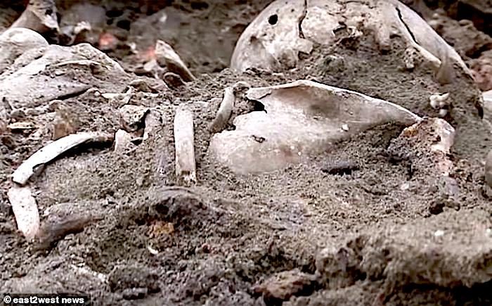
Belarus ghetto site: Mass grave found containing 1000 bodies, site of where 28K Jews were killed by Nazis

bones/dirt
© east2west newsThe remains of at least 1,000 suspected Jewish victims of the Holocaust have been discovered close to the site of a notorious Nazi ghetto at Brest where they were executed in 1942.
A mass grave with the remains of over 1,000 Jewish people slain by the Nazis has been found in Belarus. Bones of men, women and children with gunshot wounds to their skulls have been located at a building site in the city of Brest on the Polish border.

The skeletons of around 600 have been found so far, with Belarus soldiers - deployed to undertake the macabre work - now locating the remains of some 40 people each day in the sinister burial place.

City official Anna Kondak said: 'We expect the number of victims to go over 1,000.'
Nazi soldier/Jews
© east2west newsDocumentary footage shows the appalling conditions Jews were kept in under Nazi guard at the Brest ghetto between 1941 and 1942.
excavation team
© east2west newsMembers of the excavation team in Brest, Belarus, close to the Polish border examine remains at the mass grave.
truck at site
© east2west newsThe mass grave was discovered as excavations were being carried out for a new luxury residential development.