While record warmth in the West and a Sierra Nevada snow drought may continue, folks in the East were recently reminded that winter can still pack a punch.
Temperatures dipped to 17 degrees Wednesday morning in Washington, D.C. This matched the lowest temperatures of the entire season last winter. Tuesday was warmer in Calgary, Alberta, (50 degrees) than it was in Walt Disney World (49 degrees). Lake-effect snow finally hit depositing 1 to 2 feet of snow in some of the snowbelts.
Much of the nation is experiencing a lack of storms this week.
However, while there is still some uncertainty what the balance of the winter will bring, signals are pointing toward additional cold waves coming to the East and an uptick in large-scale storms beginning toward the middle of the month. The details will unfold soon.
Weather Weenies Read On
Rather than just a west to east jet stream across North America with little disturbances in it like we had during much of December, we now have much larger southward dips and northward bulges. (Think of that high school physics experiment you did with a jump rope.)
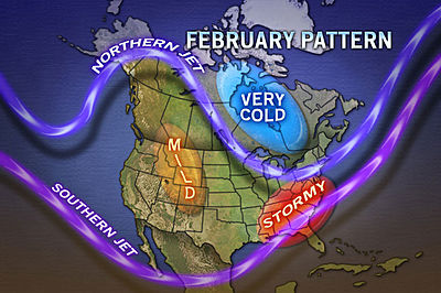
These longer wave lengths may soon help spin up larger storms and bigger extremes in temperature for a longer duration.
While there is more to defining the weather than just the presence of a La Nina or El Nino, a weak La Nina was present during most of the fall through December.
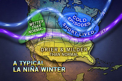
According to Expert Senior Meteorologist Henry Margusity, "Indications are the Southern Oscillation is now going neutral and the shift is fairly dramatic."
The El Nino Southern Oscillation (ENSO) measures fluctuations in southern Pacific sea surface temperatures. Fluctuations in sea surface temperatures have been studied rather intensely over the past several decades.
A warm anomaly in is an El Nino, while a cold anomaly is a La Nina.
Strong anomalies can have a profound effect on the jet stream over the northern Pacific, which in turn can greatly impact the jet stream and weather patterns in North America and throughout the globe.
"A neutral ENSO or even a weak El Nino signature if it develops could result in more of an average storm pattern across the U.S. and southern Canada," Margusity said.
"Even a normal second half of the winter in terms of storms could seem quite dramatic compared to the lame first part of the winter," Margusity added.
According to Chief Meteorologist Elliot Abrams, who keeps an eye on temperatures high in the atmosphere for potential changes down the road, "There is another round of warming going on in the stratosphere over western Canada."
Warming in this area tends to be a signature for colder weather in the Eastern states 10 to 14 days later. There was some warming prior to the cold shot that recently invaded the East.
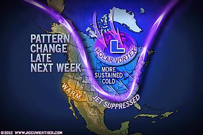
"This could be a signature for another cold wave from the Upper Midwest to the Eastern states later next week," Abrams said.
Meanwhile, the lack of the Greenland Block has kept cold air at bay near the North Pole.
The Greenland Block is a northward bulge in the jet stream that develops near Greenland and creates a subsequent dip in the jet stream over eastern Canada and the northeastern U.S. This dip drives cold air into eastern North America and can provide necessary energy for major nor'easters.
Current meteorological skill only provides insight into changes in this parameter about two weeks in advance. There is no sign of this changing over the next couple of weeks.
According to Long Range Weather Expert Paul Pastelok, "Another parameter, the Arctic Oscillation (AO) seems to be switching away from where it was during most of the fall and in December."
The AO roughly measures the magnitude of cold air in the Arctic region. When this is value is positive, the cold air is locked up in the region and mid-latitudes tend to have near- to above-average temperatures.
"When it goes negative like we are seeing now, the cold air is soon released from the Arctic and drives southward into parts of the U.S.," Pastelok said.
Study continues on these and other parameters, including lunar and solar cycles.
Different theories have emerged on the impact on the weather by each. However, since these parameters change daily and the degree of change rarely has an immediate impact, great forecasting challenges result.
In addition, a great deal more research needs to be done on how much all of these parameters interact with each other, hence affecting the outcome on the weather.
The study of weather is never-ending. While great strides have been made in forecasting over the years, there is always room for improvement.
If only we could make the atmosphere do what we want or make modifications to it if things do not work out!
One thing is certain with thousands of brilliant minds studying the weather and continuing to educate the public, forecasting will continue to improve in the years to come.


It has been in the 60's for the most part here in Eastern North Carolina since December. I anticipated a cruel winter this year based on several Volcanic Eruptions. Perhaps the effect is the opposite or perhaps it is the height of ash clouds that matters. Yet, as the article suggests, we could still be in for something very wicked. A Year without summer perhaps. The Earth has shifted and it is known that the magnetic field is on the move at 40 miles per year. The sun showed it's face two days earlier in Greenland in 2011. Is it going to do the same thing this year or rise three days earlier...or seven days? We will find out soon. Hopefully people are taking advantage of the savings on there heating bills and paying off Holiday debt.