Comment: See:
- Auto exhaust from a car park biases Scottish high temperature - Met Office denies record
- Faulty weather stations established the all-time record high temperatures for Los Angeles
It started with this tweet Friday 07/06/18: (h/t to Mike Bastasch of the Daily Caller).
The WaPo article says:
Africa may have witnessed its all-time hottest temperature Thursday: 124 degrees in AlgeriaFirst, the keyword here is "reliable". More on that below.
The planet's hottest continent probably just endured its hottest weather ever reliably measured.
An Algerian city soared to 124.3 degrees (51.3 Celsius) Thursday, adding to the onslaught of records for extreme heat set around the planet during the past 10 days.
The blistering-hot temperature reading, observed in Ouargla, is probably the highest temperature ever reliably measured both in Algeria and in all of Africa. The record was first identified by weather records expert Maximiliano Herrera.
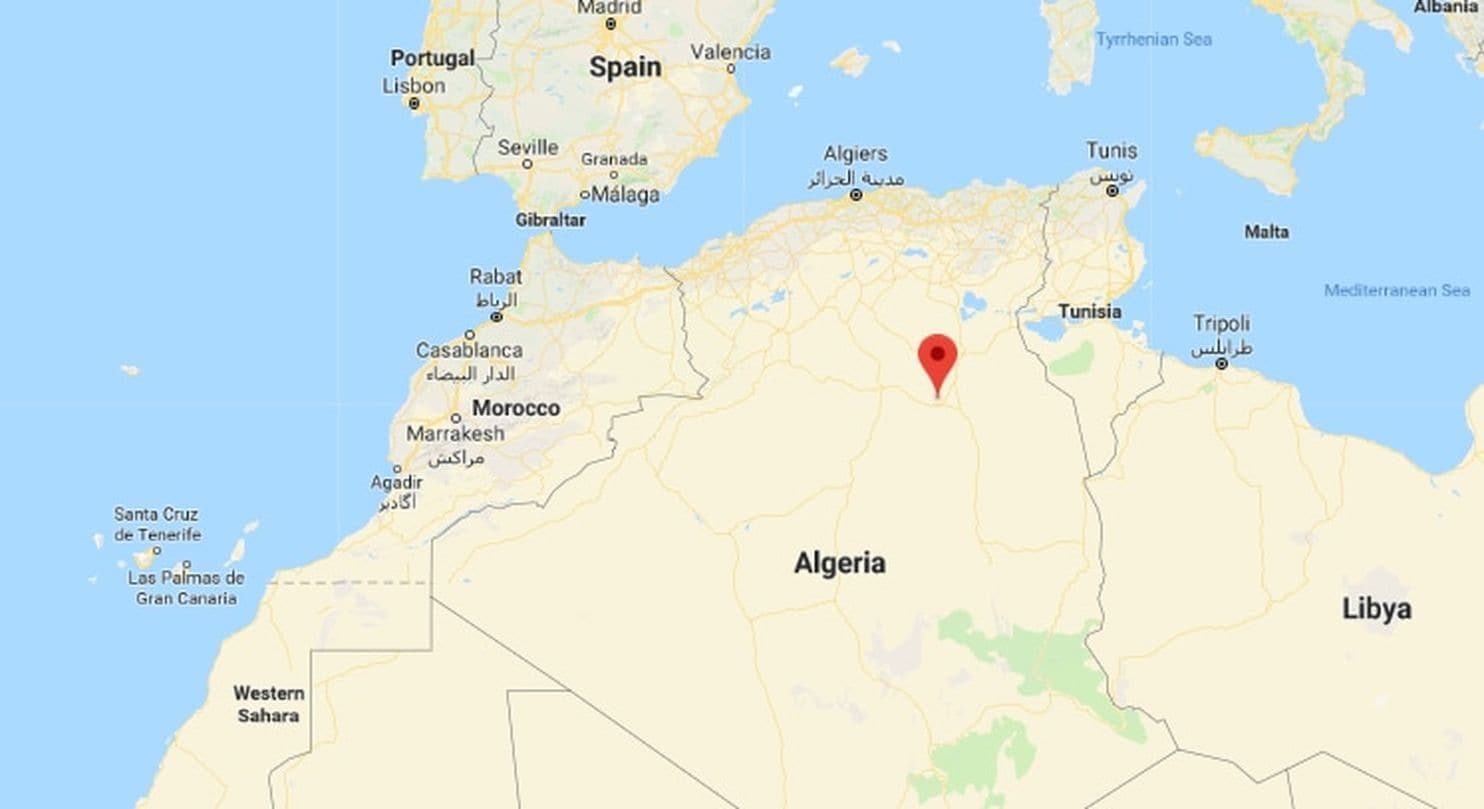
Ouargla, with a population of nearly half a million, is located in north central Algeria, roughly midway between Morocco and Tunisia.
Location of Ouargla, Algeria, indicated by red marker. (Google)
Its 124.3-degree temperature surpassed Africa's previous highest reliable temperature measurement of 123.3 degrees (50.7 Celsius) set July 13, 1961, in Morocco.
Second, the record is unverified as of this time. While the Synop data and data captured by Weather Underground both say it reached 124.3F (51.3 C) Thursday afternoon likely between 3PM and 6PM local time, it seems that even though this claimed record is being built up by WaPo as "big news" it has some real problems with it much like the rejected Scottish all-time temperature record.
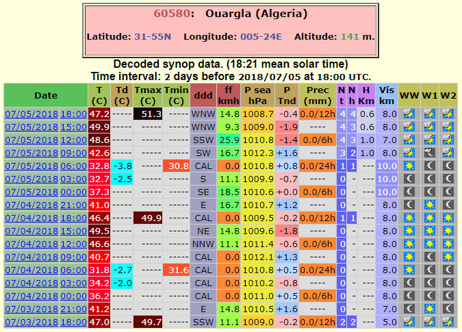
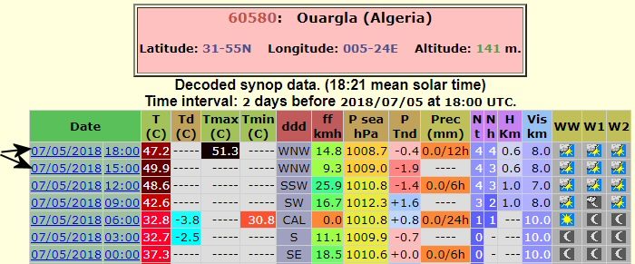
Here's the SYNOP report, note the 51.3C reading:
Note that the 51.3C Tmax reading doesn't show what time it occurred, but we can surmise based on surrounding data, likely sometime between 3PM and 6PM local time. Note also the winds during that period.
In the case of the Scottish record, the Met Office in the UK investigated and said:
"At first review the Motherwell record appeared plausible given the wider conditions on the day and was therefore reported as such. However for all new records we undertake further careful investigation to ensure that the measurement is robust. This investigation includes statistical analysis of the station data, evaluation against neighbouring sites, and in some cases an additional site visit to check for unexpected issues with the instrument enclosure or equipment to ensure the measurement meets our required standards."So, the issue was siting. Turns out it was an Ice Cream Truck parked nearby the station. Temperature was measured in the wrong place where an unexpected bias creeps in.
"Unfortunately in this particular instance we have evidence that a stationary vehicle with its engine running was parked too close to the observing enclosure and the Stevenson screen housing the thermometers during the afternoon of 28th June," the Met Office explained.
"Although the measurement appears plausible given the weather conditions that day we cannot rule out the potential for contamination of the measurement by this non-weather-related factor," officials wrote.
Third, The Algerian Met Office doesn't seem interested. In the case of Ouargla you'd think the Algerian Meteorological Office HQ in Algiers would at least have a mention of "probably the highest temperature ever reliably measured both in Algeria and in all of Africa."...but, they don't. Either they are unaware, or don't think it's meteorologically/climatologically important. What I found below in #5 may be why they aren't touting it.
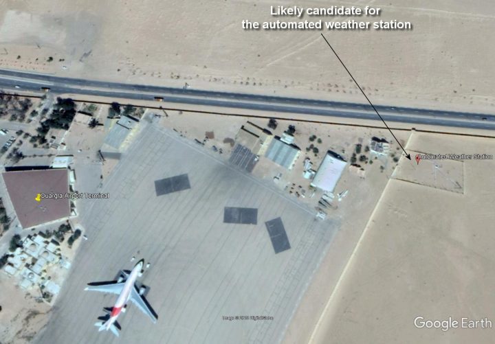
Fourth, the thermometer location is at an airport with a large military presence, right next to the tarmac. Based on hours of combing Google Earth and other sources, I have identified what I believe to be the weather station at Ouargla Airport (OGX) now known as Ain Beda airport (ICAO code DAUU). See the captioned photo from Google Earth below:
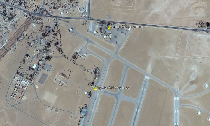
Source: https://www.google.com/maps/@31.935836,5.4105054,286m/data=!3m1!1e3
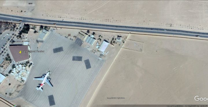
Airports are NOT good places to measure climate change or even record highs/lows. Why? they are dynamic places; jet exhaust, changing infrastructure, and constant energy use. Just look at the small area for the jet above, it has to make a 360 rotation and that spews jet exhaust everywhere. Does it affect the temperature sensor? Who knows for sure without a flight schedule to compare to the temperature record, but if the Met Office can disqualify an all-time high temperature record for an Ice Cream Truck parked nearby spewing exhaust, you'd think meteorological authorities would want to look at whether jet airplanes are doing the very same thing at Ouargla Airport.
Fifth, the airport is under construction at the moment. An extension/expansion of the public terminal facility is happening in 2018 as indicated by this article in 2017:
http://www.elmoudjahid.com/fr/actualites/117511
Translation from French:
https://translate.google.com/translate?sl=fr&tl=en&js=y&prev=_t&hl=en&ie=UTF-8&u=http%3A%2F%2Fwww.elmoudjahid.com%2Ffr%2Factualites%2F117511&edit-text=
A project to extend the terminal of Ain El Beida airport in Ouargla will be launched in 2018, according to the director of transport of the wilaya. The technical studies relating to this operation have been completed and work will start in the course of next year...So for all we know, since we have no Google Earth imagery past March 2018, the airport may be torn asunder, darkened earth may be exposed, changing the albedo, and therefore the ground influenced air temperature in full sun, or the thermometer may be moved and compromised in other ways. We won't know until we get some on-the-scene photos.
Sixth, based on the location of the AWS (automated Weather Station) temperature sensor in March 2018 and wind data, the all-time African high temperature record may be a product of poor placement, wind, and heat transport (or jet exhaust).
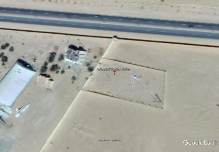
I spent several hours trying to locate the temperature sensor. There were several possible candidates, and I've narrowed it down to one. Unfortunately, since Ouargla Airport is not a popular destination, and because there's little ground photography available (likely due to the military base presence) I've had to rely on Google Earth only. Here's what I found as the likely candidate:
Ouargla airport - best candidate for the automated weather station. Click to enlarge.
Here is a close-up view:I looked at all sorts of structures and identified them, ILS radio towers, communication towers, floodlight poles, wind tees, wind socks, etc. and this small fenced in tower near the approach of runway 20 is the only structure that makes sense for the following reasons:
- It's near the terminal and admin building - shorter wiring distances to where the data is needed.
- It's a public facility, with public reporting of weather data, not a military weather station, so it makes sense it would be closer to the public area.
- It is positioned in the runway approach area and is fenced in to keep people away. AWS are used for runway conditions, not climate, so makes sense where it is placed and fenced.
- The tower is about the right height for an AWS, typically 10 meters (30 feet) for the anemometer/windvane, and the temperature sensors are almost always close to that sort of tower because they want all the readings at the same place.
- Nothing else I observed in the entire area fits the bill for an AWS tower. Most all others are too tall.
According to the SYNOP report, when the high temperature was set, it likely happened between 3 and 6PM local time based on other hourly Tmax data:
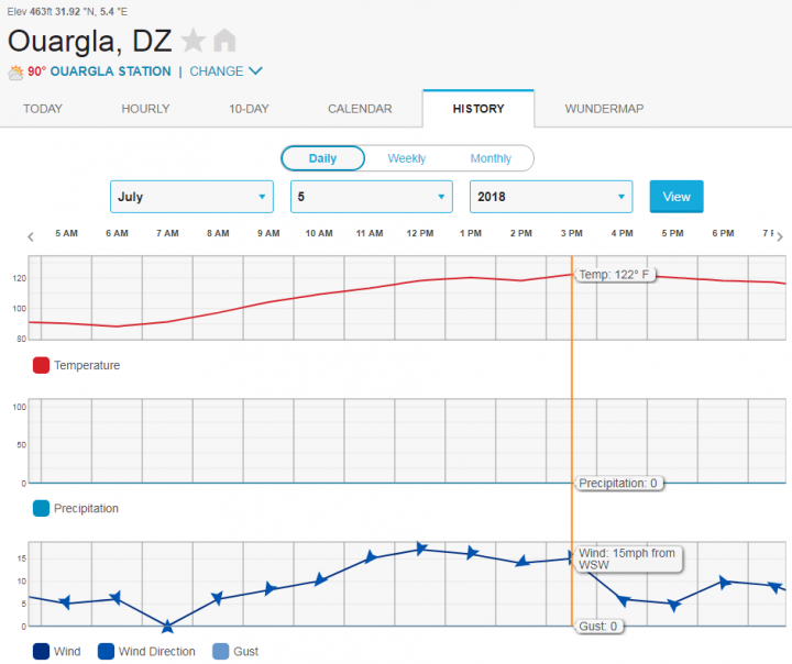
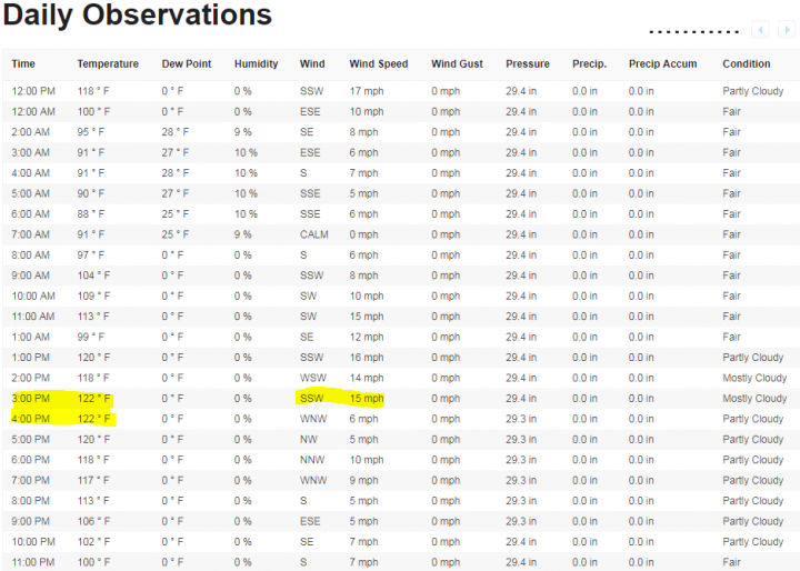
We can narrow the likely time of the 124.3F/51.3C Tmax down further with archived data from Weather Underground:
Note that at 2PM the temperature was gown down, but at 3PM it hit 122F (49.9C) and at the same time there was a wind shift to the WSW SSW with average wind of 15mph. 3PM is also about the time to expect peak solar insolation for that location, which leads to maximum ground heating.
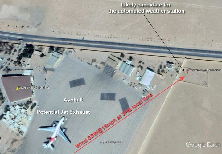
Assuming I have the AWS temperature sensor placement right, guess what is upwind of the AWS when the wind is coming from the WSW SSW?
That's right, a big slab of asphalt tarmac and a big source of jet exhaust as seen below with my annotated Google Earth image:
One thing is for certain, with that wind direction, there was most certainly heat transport toward the AWS from the tarmac and terminal. I don't know if there was a jet plane present and taxiing at that time or not, but if there was, the jetwash would add to the heat transport.
I believe that the Ouargla "all time African high temperature record" is based on artificial heating sources and heat transport by wind at the opportune moment and best direction for heat transport from the airport tarmac and/or jetwash.
I also submit it has NOTHING to do with global warming/climate change but is little more than a combination of a warmer than normal meteorological synoptic-scale event for the region, combined with poor thermometer placement and a wind driven heat transport event.
In my view, this temperature record should be disqualified as being influenced by man-made objects, just like the Ice Cream truck parked next to the weather station in Scotland.
I welcome comments, and if anyone can get an "on the ground" confirmation of my theory, such as photos or videos, please share it in comments.
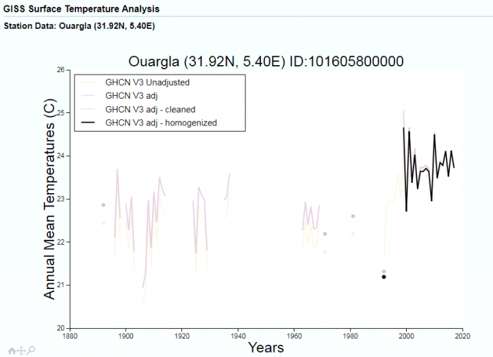
One final note. NASA GISS uses this station as part of the GHCN (Global Historical Climate Network) data provided by NOAA. After looking at the fractured record, and the above scenario, any sensible person would ask WHY?
Moral of this story: We shouldn't rely on airport weather stations for anything to do with climate records. They are placed for aviation purposes, not for climate purposes, and are active energy sources, heat sinks, and unnatural/artificial terrain that is unrepresentative of the area's climate.
UPDATE: A day after this post was published, a typo was noticed in the wind direction in the text (should have been SSW, not WSW) and was corrected in both the post body and the image with wind direction. The typo doesn't change the conclusions of the essay.



Comment: Mainstream science these days is all about confirmation bias and prostituting reality for 'research' grants: