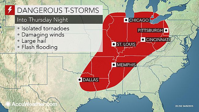
The risk of severe thunderstorms, including a few tornadoes, will continue over the Central states and will begin to shift eastward and expand northward into Thursday night.
Following
violent storms from Wednesday, thunderstorms into Thursday evening will stretch from northeastern Texas to southern Wisconsin, lower Michigan, southwestern Ontario, Ohio, West Virginia and part of western Pennsylvania. The storms have the potential to be severe within this swath, home to approximately 60 million people.
According to AccuWeather Senior Meteorologist Henry Margusity, "The risk of tornadoes will affect parts of Illinois, Indiana, Iowa and Missouri, which represent a fairly heavy population density."
"The risk into Thursday evening includes the metro areas of Chicago and St. Louis," Margusity said.
A second area of slightly higher risk for tornadoes extends from northeastern Texas to northwestern Louisiana and southeastern Arkansas.
Extensive cloud cover hindered severe thunderstorm development into the early afternoon hours on Thursday. The sun burned through the clouds and warmed the region at mid-afternoon, causing thunderstorms to erupt and turn severe.
The storms can bring damaging wind gusts, large hail, frequent lightning and blinding downpours in some communities. A small number of the storms can produce a tornado.
Other cities that have the potential to be hit by damaging, dangerous and disruptive storms on Thursday include Milwaukee; Indianapolis; Cincinnati; Pittsburgh; Louisville, Kentucky; Peoria, Illinois; Davenport, Iowa; Charleston, West Virginia; Memphis, Tennessee; Little Rock, Arkansas; Shreveport, Louisiana; and Longview, Texas.
Locally severe storms may reach as far to the northeast as Detroit, Cleveland and London, Ontario, during Thursday night.
In addition to the dangerous aspect of the storms, travel disruptions ranging from blinding rain and flooded roadways to flight delays and cancellations are likely. Chicago's O'Hare Airport is one of the busiest airports in the world. People should allow extra time to get to their destinations and never attempt to drive through flooded roadways.
"The severe weather outbreak [spanning multiple days this week] will include hundreds of incidents of damage from wind and hail, as well as perhaps a number of dangerous tornadoes," Margusity said.
Heavy, gusty and locally severe thunderstorms are likely to continue to
push eastward and southward on Friday. Storms will venture east of the Appalachians and approach the Atlantic coast. The risk will extend southward to the central and western Gulf coast. Some storms will produce damaging winds and hail.
AccuWeather will continue to provide updates on the unfolding severe storm and tornado threat through the week.

Comment: See the latest Earth Changes video summary from the SOTT team:
SOTT Earth Changes Video Summary - March 2015: Extreme Weather, Planetary Upheaval, and Meteor Fireballs