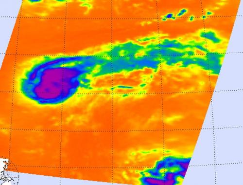
Tropical Storm Kirk looks more like a comet than a tropical storm in infrared imagery from NASA's Aqua satellite because of wind shear. NASA infrared imagery also revealed powerful thunderstorms around the center of circulation which are indicators that Kirk will continue strengthening. Meanwhile, another low pressure area appears to be organizing in the eastern Atlantic, far to the southeast of Kirk.
Tropical Depression Kirk formed from the eleventh tropical depression of the Atlantic Ocean season. Tropical Depression 11 formed on Aug. 28 at 5 p.m. EDT about 1,270 miles (2,045 km) east-northeast of the Lesser Antilles. On Aug. 29 at 12:29 a.m. EDT the Atmospheric Infrared Sounder (AIRS) instrument on NASA's Aqua satellite captured infrared data on Tropical Storm Kirk's clouds.

© NASA/JPL, Ed OlsenOn Aug. 29 at 12:29 am EDT the AIRS instrument on Aqua captured infrared data on Tropical Storm Kirk's clouds. Cloud top temperatures were colder (purple) than 63F (-52C) around the center of circulation and west of the center. That's where the strongest storms and heaviest rainfall were occurring. Kirk appears to resemble a comet because windshear is pushing clouds and showers to the northeast.


Reader Comments