© Unknown
With the disaster modeling program on his computer, project analyst Adam Campbell dials up a 7.2 earthquake for Seattle and King County.
He's looking for how many buildings will topple, how much debris will fill the streets, making them impassable for emergency responders. He wants to know how many casualties the massive quake will produce.
"Cascadia is a scary fault," said Campbell, a contractor for Federal Emergency Management Agency, in what will prove to be an understatement, as he demonstrates the program to The Associated Press,
Minutes later, FEMA's Hazus computer program churns out its hair-raising answers: Billions of dollars in structural damage; area hospitals leveled; tons of debris blocking the streets, and more than 1,000 deaths and several more thousand injured.
"The data that comes out of a tool like Hazus shows our risks and what kind of impacts could occur here," said John Schelling of the Washington Emergency Management department. "The program brings some resolution. It provides some context so people can begin to see some of the challenges following these types of disasters."
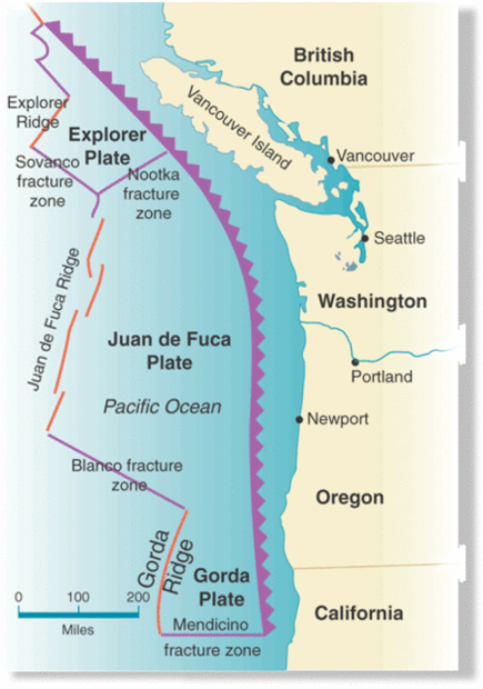
Of particular worry to government agencies - and emergency planners like Schelling - is the 680-mile long Cascadia fault line, which runs just 50 miles off Washington's shore. Scientists have found that a big 8.0 to 9.0 earthquake has hit that fault line about every 500 years. The last one struck in 1700.
According to a 2005 study that used Hazus data, such a strong earthquake would level parts of the region, bringing landslides, tsunamis, fires, and spilling hazardous materials among other disastrous effects. This year, FEMA will partner with the Canadian government to do a bi-national model of a 9.0 earthquake hitting the Pacific Northwest, creating an updated examination of the 2005 study.
"There's going to be impact to infrastructure, to bridges and roads that we rely on every day," Schelling said. "It may provide another source of information that people can recognize and say, 'I can see why I need to be prepared because there's going to other challenges for responders to deal with.'"
It might sound like grim information to project and map, but providing such data for free is FEMA's goal in helping local and state agencies to be more prepared for disaster.
It's "only on paper until an actual event strikes," said Eric Berman, the Hazus program manager, after seeing the data. "What makes my work rewarding is that we can help prevent losses...our biggest thing is to reduce the loss of life and damage to property."
Hazus was created after a 1992 report from the National Academy of Sciences. The first version debuted in 1997 with only earthquake modeling. By 2004, FEMA added flood damage estimates and six years later modeling for hurricanes was introduced.
Next on the list is tsunami modeling.
This past week, dozens of emergency managers, geologists and state and local preparedness planners gathered in Seattle to learn about and give feedback about the program in the 5th annual Hazus conference.
Washington state has plans in place in case the big one strikes, Schelling said. But he also encouraged all citizens to take the time to do simple preparedness tasks, like choosing a rendezvous point to meet after an earthquake. He added that besides earthquakes, the state has plans for eruptions at all of the active volcanoes in the region, including Mount Rainier.
Schelling also warned that earthquake danger is not only for western Washington. He said an earthquake shook underneath Chelan in 1872 and emergency planners also think an earthquake can strike Spokane.
Berman said it has cost the federal government millions of dollars to develop the Hazus program. Over the years it has steadily built up its data inventory of conceivable disasters.
Using data collected from the Census and a private research company, the program churns different scenarios, and how each would impact many variables of life. The data collected includes information on building types and values in each city. That way the program can estimate how much debris those buildings would produce and how much monetary damage it would cost if those structures are leveled.
In the earthquake demonstration shown to the AP, the program estimated casualties at different points in time and location. Fewer deaths occurred in the middle of the night, but if the earthquake struck at 2 p.m., the number of casualties in commercial buildings spiked. The program also estimates how many hospitals, schools and police stations would be damaged. (The model did not list specific buildings, and FEMA personnel cautioned that the model shown to the AP was not vetted by analysts.)
In a disaster zone, Campbell said, shelter needs are one of the most important contingencies to plan, and the program's estimates of how many buildings would be damaged can provide a useful framework for emergency planners.
The Hazus program was used last year to map flood damage in south King County in case the banged up Howard Hanson Dam failed, said Ryan Ike, a risk analyst for FEMA in Seattle.
"It's about recovery versus rescue," Ike said. "It's the 24 hours after a disaster to get people out."
Reader Comments
to our Newsletter