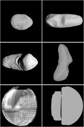
"Then you punched the number into the computer and figured out the latitude and longitude," recalled Robert W. Gaskell, a planet-mapping expert. The result was two-dimensional, with only hints of surface texture or complexity.
No more. With modern computers, digital photography and laser range-finding, scientists today do a much better job of pinpointing the locations of their spacecraft, picking landing sites and otherwise describing the solar system's extraterrestrial landscapes.
And nobody does it better than Dr. Gaskell. With software he developed over a quarter-century of trial and error, he can process hundreds of images in a few hours, slap them atop one another electronically like coats of paint and produce a topographical map so detailed that you often need a pair of 3-D glasses to appreciate what he has done. At 63, Dr. Gaskell has become the Captain Cook of space.
He retired from the NASA Jet Propulsion Laboratory in 2006 so he could make maps full time, and he now works in a computer-filled office at his home in this suburb northeast of Los Angeles. He is affiliated with the Planetary Science Institute, based in Tucson, but he gets his own grants and could be described as a freelancer.
Just now Dr. Gaskell is mapping all of Mercury and eight moons of Saturn. He also has a NASA contract to do part of a topographical map of Earth's Moon, and he is working on a project to refine his model of the near-Earth asteroid Eros. He has made 12,000 overlay "maplets" of Eros from images produced by the NEAR spacecraft at the turn of the century. In all, NEAR made 160,000 digital images, and "I'm doing 1,000 at a time," Dr. Gaskell said.
Dr. Gaskell calls what he does "stereophotoclinometry." Ideally he needs at least three images of the target landscape, usually taken by an orbiting spacecraft or a probe on a flyby to another destination. Only in rare cases can telescope images provide enough detail.
The sun angle must be different for each exposure so each image shows different shadows. By comparing the shadows, the software calculates slopes, which yield the altitudes of target features. The computer solves the equation in three dimensions, producing a patchlike topographical maplet.
The goal is to create a 3-D model of an entire body. A first take can be done quickly, but more images and more maplets produce more overlap and overlay, sharpening the topography until the scientist runs out of pictures. Dr. Gaskell started working on Eros in 2002.
A graduate of McGill University with a Ph.D. in physics, Dr. Gaskell began his celestial mapmaking career in 1984, but it was 1989 before he got an inkling of what might be possible, using images from the Voyager spacecraft to study Jupiter's volcanic moon Io. He built his map by comparing the brightness of a feature in different images. He did not have enough computing power to pay attention to sun angles, but, he said, "I intuitively knew that different illuminations could give more information."
The first of two "aha!" moments came around 1995, when he was using NASA's Viking images to map possible landing points on Mars. The images were taken with a variety of sun angles, and Dr. Gaskell realized "in about a millisecond" that with the computing power he now had, he could calculate slopes and, therefore, build topographies.
He refined his technique, and in 2000 he used it to map Phobos, Mars's largest moon, so a Mars lander could use the map as a navigational aid. "I had maybe 100 maplets," Dr. Gaskell said. "But then I thought to myself, Why not do the whole thing? I could pick more points closer together and overlap the maplets. It wouldn't be any harder."
So he did it. Phobos, it turned out, looks like an elongated, heavily cratered, opaque Idaho potato. Dr. Gaskell's first topographical model had 146 maplets.
Eros came next, and currently has 12,000 maplets. And in his last job for the jet propulsion lab, in 2005, Dr. Gaskell was seconded to the Japan Aerospace Exploration Agency to build a topographical model of the asteroid Itokawa, another near-Earth object about 1,650 feet long, using images from the agency's Hayabusa spacecraft.
He is now working on Mercury, a project that does not look like much yet. Mariner 10 made three passes in 1974-75, but the sun angle was the same in all of them, so there is little variation in the exposures. The Messenger spacecraft has made two flybys, providing lots of new material but little overlap. Once the spacecraft settles into orbit around Mercury in 2011, however, Dr. Gaskell will have all the images he wants.
He freely acknowledges he has more work than he can handle, and, far from jealously guarding his secrets, he is eager to teach others his technique. At this point Dr. Gaskell's software can integrate all kinds of information and make it look easy. It can use images at high resolution, images at low resolution, laser readings and even radar ranges from radio telescopes (for Itokawa).
"His approach is unique," said the geophysicist Olivier Barnouin-Jha of the Johns Hopkins University Applied Physics Laboratory, a Gaskell collaborator on the Eros, Itokawa and Mercury projects. "But it's not quite as nice as a black box. There's a lot of handholding and agonizing that goes into this."


Reader Comments
to our Newsletter