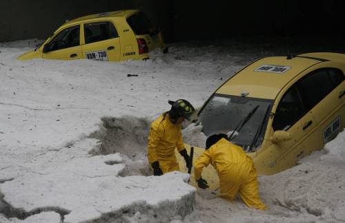
Colombia's capital, Bogota, was hit by a freakish hailstorm on the weekend that rendered vehicles immobile. Cars were trapped under a cover of hail that reached up to 1.5 metres in height in some areas.
In one hour, 70 litres of hail had fallen per cubic metre in the Andean city trapping some individuals in their cars in freezing temperatures. Colombia has been troubled by a series of natural disasters so far this year, mainly in the form of flooding, which has caused the deaths of 94 people. The country's Institute of Environmental Studies has warned that the hostile weather system known as "La Niña" could continue to trouble Colombia until January.
Meanwhile, President Alvaro Uribe faces his own challenges in relation to the country's armed conflict. Another two members of his ruling coalition--Senator Luis Humberto Gomez and deputy Gonzalo Garcia--were called to give evidence to the Supreme Court over the paramilitary-politico scandal. Efforts towards a rapprochement with the leftist Revolutionary Armed Forces of Colombia (FARC) rebels continued with Venezuelan President Hugo Chavez due to meet French counterpart Nicolas Sarkozy on 20 November to discuss efforts to secure the release of 45 civilian and military hostages. Another FARC rebel, named as Jorge Rodriguez Mendieta, was extradited to face trial in the United States two days ago.
Significance:After Saturday's storm, incoming mayor to the capital Samuel Moreno, who hails from the leftist Alternative Democratic Pole (PDA), will be under increased pressure to improve Bogota's transport system and overall operational environment. Bogota's infrastructure is inadequate to deal with such hostile conditions. The storm that hammered Bogota on Saturday (3 November) was the worst that the city has seen for 30 years. What appears to be snow on television footage was actually a mass of hail, which has greater potential to damage infrastructure and cause injury.
Comment: Amazingly, the story is getting very little international press. This storm ranks at least on par with the recent flooding in Mexico. This video shows how dire the situation was:
The map below shows the effect of el Nino on precipitation. Since we're now in the la Niña part of the ENSO (El Nino Southern Oscillation) cycle the red indicates increased precipitation and the blue reduced precipitation for September through November. The area around Columbia shows increased precipitation so the event, or its severity, can probably be ascribed to the la Niña.
September-November This season the effects of El Niño are strongest. Almost all of Indonesia, the Philippines and eastern Australia are drier than usual during most El Niño events. Large parts of India are often drier than usual, but the Sri Lanka and some southern states get more rain. East Africa, parts of Central Asia and Spain are also on average wetter than normal during El Niño in this season, as are Chili and Uruguay.
The figure below shows the effect of el Nino on precipitation for December through February. Again, reverse the correlation since we're in a la Niña period.
December-February In boreal winter the Philippines and East Indonesia stay drier, whereas the Pacific islands along the equator remain wetter. Florida also gets more rain than normal during El Niño, this effect extends to other southern states of the U.S. and into Mexico. South Africa is more frequently dry, as is the northern coast of South America and some of the leeward Antilles. In Uruguay en South Brasil rainfall increases on average. Along the coasts of Ecuador and Peru rainfall increases when the coastal waters heat up, an effect also named El Niño but not always coincident with the warming along the equator that affects the rest of the world.
Notice the large blue area in the southeastern part of the US, meaning reduced precipitation. The southeast US is already suffering from an extreme drought which can see Atlanta run out of water within 90 days.
As if the summer wasn't hot enough, now we face an unusually warm winter with temperatures expected to be 3 to 5 degrees above normal, the National Weather Service in Miami said Wednesday.
And don't blame global warming. If its predictions holds true, the weather service said, it will mainly be the work of La Niña, the same weather phenomenon expected to reduce rainfall and plunge South Florida back into severe drought by next spring.


Comment: Amazingly, the story is getting very little international press. This storm ranks at least on par with the recent flooding in Mexico. This video shows how dire the situation was:
(Thanks to SOTT reader, Alejo)
The map below shows the effect of el Nino on precipitation. Since we're now in the la Niña part of the ENSO (El Nino Southern Oscillation) cycle the red indicates increased precipitation and the blue reduced precipitation for September through November. The area around Columbia shows increased precipitation so the event, or its severity, can probably be ascribed to the la Niña.
September-November This season the effects of El Niño are strongest. Almost all of Indonesia, the Philippines and eastern Australia are drier than usual during most El Niño events. Large parts of India are often drier than usual, but the Sri Lanka and some southern states get more rain. East Africa, parts of Central Asia and Spain are also on average wetter than normal during El Niño in this season, as are Chili and Uruguay.
This "La Niña is much better defined than last year -- right up there with the strongest we've ever seen. The ocean temperatures off the South American coast are the coldest since 1950."
The figure below shows the effect of el Nino on precipitation for December through February. Again, reverse the correlation since we're in a la Niña period.
Notice the large blue area in the southeastern part of the US, meaning reduced precipitation. The southeast US is already suffering from an extreme drought which can see Atlanta run out of water within 90 days.
And not just Georgia will be affected: This is bad timing for the southeast US.