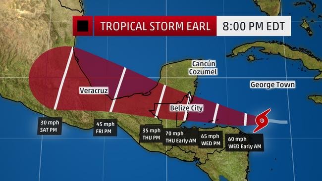
Earl will track toward Belize and Mexico's Yucatan Peninsula, where strong winds and heavy rainfall will be threats late Wednesday into Thursday. Current indications are that the chance of a direct impact on the U.S. from Earl is low.

The red-shaded area denotes the potential path of the center of the tropical cyclone. Note that impacts (particularly heavy rain, high surf, coastal flooding) with any tropical cyclone may spread beyond its forecast path.
Tropical storm warnings and hurricane watches have been issued for parts of the Yucatan Peninsula, from Punta Allen, Mexico, to the Belize/Guatemala border. A tropical storm warning is also in effect for Honduras from Cabo Gracias a Dios westward to the Honduras/Guatemala border, including the Bay Islands.
This system has already been impactful the last few days prior to being named Earl. Six people were killed in the Dominican Republic Sunday into Monday as this system passed near the island.
Here is what to expect from Earl.
Earl Latest Status and Forecast
The center of Earl was located less than 400 miles east of Belize City, Belize, as of Tuesday evening. Earl was moving toward the west at 16 mph. In the near term, showers will impact Jamaica and the Cayman Islands Tuesday evening.
Some local flash flooding can't be ruled out over the mountainous terrain of Jamaica.
Beyond that, thanks to strong high pressure aloft over the southern United States, it looks most likely that Earl will be steered toward the coast of Belize or Mexico's Yucatan Peninsula late Wednesday or early Thursday, either as a tropical storm or, perhaps, even a low-end hurricane.
Bands of locally heavy rain, and, if the center track of Earl is far enough south, strong winds, may be felt in parts of Honduras, as well from Tuesday night into possibly Thursday.
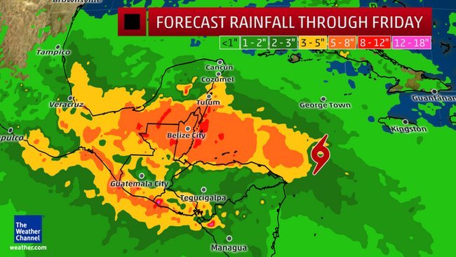
Then, the heavy rain swath tracks through northern Honduras, Belize, Guatemala and parts of the Yucatan Peninsula into southern and eastern Mexico. Flash flooding and mudslides in mountainous terrain are threats.
Rainfall totals of 8-12 inches (locally up to 16 inches) are possible along the path of Earl in parts of Belize, Honduras, Guatemala, and the Yucatan Peninsula of Mexico.
Near and north of where the center makes landfall, water levels may be 2-4 feet above normal tide levels, the National Hurricane Center said. This could cause some coastal flooding along the immediate coastline of Belize and adjacent parts of Mexico.
By Friday, the system, assuming it survives the voyage over land, may emerge over the Bay of Campeche and restrengthen before a second landfall most likely in eastern Mexico this weekend.
Any U.S. Impacts?
For now, the chance of U.S. impacts appears very low, with the exception of a possible push of moisture and showers into parts of the Texas coast.
That said, given that this forecast is still several days way, check back for any possible changes.
Rip currents may also impact the Gulf Coast.
August and September: More Favorable For Development
Tropical waves that emerge off the African coast often develop around or even well after passing the Cape Verde Islands. Earl developed from one such tropical wave.
Meteorologists make frequent references to the "Cape Verde" season, which is essentially a season within the overall hurricane season. Most Cape Verde storms develop from mid-August until late September.
There are so many "mouse traps" (unfavorable conditions) in the Atlantic that very few of these Cape Verde tropical storms and hurricanes ever make it all the way to the United States. But there have been some notable Cape Verde storms that made it to the East Coast of the U.S., such as the 1938 Hurricane, Hurricane Hugo in 1989 and Hurricane Andrew in 1992.
Development of tropical waves into tropical storms or hurricanes is determined by several environmental factors that can range from somewhat favorable to extremely favorable, including:
- Ocean temperatures
- The orientation of ridges (high pressure) and troughs (low pressure) aloft
- A moist environment
Tropical systems like to have winds that are roughly the same speed and direction through a depth of the atmosphere for maximum development. Wind shear - changing winds with height - tends to break up tropical systems that are trying to develop, displacing convection away from a center of circulation.
This often occurs when a trough of low pressure aloft is to the west of a tropical weather system, such that west to southwest winds aloft combine with the typical tropical east-northeast trade winds to produce wind shear.
In August and September, a high-pressure ridge aloft, known as the Bermuda-Azores high, often expands and creates a more favorable environment for development. Atlantic systems are often steered toward the western Atlantic, Caribbean Sea and sometimes all the way to the U.S.


Reader Comments
to our Newsletter