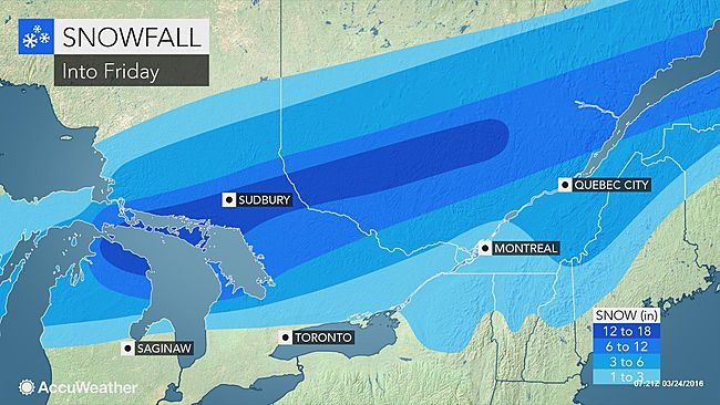
Heavy snow and ice from an early spring storm will threaten to cause travel problems and power outages from parts of Wisconsin and Michigan to a large part of Quebec prior to the end of the week. The same storm producing
blizzard conditions over parts of Colorado and Wyoming on Wednesday will spread a swath of snow and ice across the Great Lakes region, St. Lawrence Valley and areas farther north in Canada.
Road conditions will vary from wet to slushy during the day. However, lower road surface temperatures at night will cause paved surfaces to range from slushy to icy and snowcovered.
A band of 12-18 inches (30-45 cm) of snow will extend from Alpena, Michigan, to Sudbury, Ontario. In some cases, the snow will fall at the rate of 1-2 inches (3-6 cm) per hour.
Airline passengers and motorists should anticipate significant delays with possible road closures and flight cancellations. Disruptions to daily activities are possible. The snow and ice will weigh down tree limbs. Enough of a breeze can occur during the storm to cause the tree limbs to shift and break, perhaps leading to sporadic power outages.
Although freezing rain is increasingly rare in the spring, it can occur under the right conditions.
Up to 0.50 of an inch of freezing rain glazed surfaces in central lower Michigan during Thursday morning."The greatest risk for a significant period of freezing rain and sleet into Thursday night is from central Ontario to part of southern Quebec," according to AccuWeather Senior Meteorologist Brett Anderson.
The snow and ice will graze northern parts of New York state, Vermont and New Hampshire, as well as northwestern Maine and northern New Brunswick.
"The greater Toronto, Ottawa and Montreal areas will receive a mixture of rain, ice and wet snow from the storm," Anderson said.
"The worst conditions in Toronto will be the Thursday morning commute, when below-freezing temperatures will make untreated roads and sidewalks very slippery," Anderson said.
Similar slippery conditions can occur north and west of Detroit, including Lansing and Flint, Michigan, during the Thursday morning commute.
"Conditions from Ottawa to Montreal and Quebec City will deteriorate as snow changes to sleet and freezing rain later Thursday and continues Thursday night," Anderson said. "The heaviest snow will fall north of these cities."
In the wake of the storm, daytime temperatures will be above freezing and and nighttime temperatures will be below freezing for a few days. Runoff from melting during the day will freeze at night, leading to areas of black ice.

Reader Comments
to our Newsletter