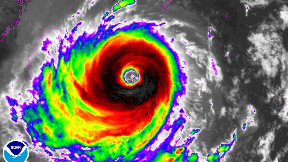
According to Twitter reports, the community of Su'ao Township was particularly hard hit by strong winds. Meanwhile, in Taiwan's mountains, torrential rain is falling and will continue to do so through Monday night local time.
More than two feet of rain is expected in some areas.
Because of the southward jump in the storm center as the storm made landfall — a movement that was likely related to frictional forces the storm encountered as its circulation slammed up against the mountainous terrain of north central Taiwan — Taipei was spared the worst winds from the storm, but it is still seeing strong winds and heavy rain.
Typhoon Dujuan continued its Category 4 intensity into Monday afternoon local time in Taiwan. With torrential rains and crashing waves battering the northeastern coast, thousands were evacuated from Taiwan's Green Island and Orchid Island.
Landfall is predicted at around 11 p.m. local time (11 a.m. ET).
In the morning in Taipei, the typhoon had maximum sustained winds of 140 miles per hour, or 63 meters per second, though this may be a slight underestimate.
Monstrous waves crashing into small section of Suao port in #Taiwan as #typhoon #Dujuan nears pic.twitter.com/Xu63505moH
— James Reynolds (@EarthUncutTV) September 28, 2015Heavy rain from the influences of the storm was already falling in parts of Taiwan as Monday dawned.
Typhoon warnings as well as warnings for heavy rainfall, which will bring with it the risk of landslides and flooding, have been issued for much of Taiwan, where mountainous terrain squeezed more than 50 inches of rain out of a typhoon earlier this season. The strongest winds and worst coastal flooding is expected to occur along and to the north of where the storm's center comes ashore, while flooding rains can be expected across the entire island.
As of Sunday morning, the storm was the equivalent of a Category 4 hurricane, with maximum sustained winds of 140 miles per hour, or 63 meters per second. It was still intensifying, and may peak near 150 miles per hour in intensity, which would make it a super typhoon.
The storm is likely to weaken to Category 3 or back to Category 4 intensity before it hits the northeast coast of Taiwan, with the potential to produce widespread wind damage, mudslides and flooding from heavy rain as well as a powerful storm surge, depending on the angle with which it approaches the coast and the timing of landfall.
The storm will also affect the southern Ryukyu Islands of Japan, which have been pummeled by multiple typhoons so far this year.
Taiwan is used to encounters with typhoons, and so far this year the island has been buffeted by at least three other typhoons. Typhoon Soudelor, which made a direct hit on the island nation, dumped upwards of 50 inches of rain, leading to major flooding.
Because of Typhoon Dujuan's slow movement — it was moving west at just 8 miles per hour as of Sunday morning eastern time — it too threatens to produce flooding rainfall as well.
In addition, the storm has a large eye at least 40 miles in diameter, surrounded by a solid ring of towering thunderstorms. Such typhoons, which are distinguished from storms that have smaller eyes and a more narrow "eye wall" of storms surrounding the storm's center, are known as annular tropical cyclones.
They can be more resistant to rapid weakening than more ordinary typhoons, according to WeatherUnderground.
The timing of the storm's landfall in northern Taiwan looks to be during the overnight hours on Monday local time, with the peak of the storm coming during the day on Tuesday. (Taipei is 12 hours ahead of New York.)
Computer visualization of the winds spinning around the center of Typhoon Dujuan on Sunday September 27, 2015.
The Central Weather Bureau in Taiwan says there is an 85 to 90% chance that areas in northern Taiwan, including Taipei, Keelung and Yilah will see sustained winds stronger than about 40 miles per hour. (In this case, the actual winds are likely to be significantly stronger than that.)
The Bureau has issued typhoon warnings as well as warnings and advisories for heavy rain across northern Taiwan, including Taipei.
Once the storm passes Taiwan, it is forecast to emerge over the South China Sea as a moderate typhoon, and make its final landfall along the coast of Fujian Province, China.


Reader Comments
to our Newsletter