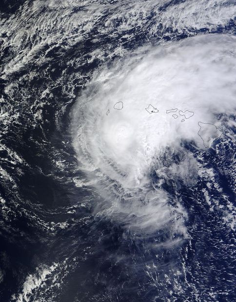
The Moderate Resolution Imaging Spectroradiometer aboard NASA's Terra satellite captured a visible picture of Tropical Storm Ana blanketing the Hawaiian Islands on Oct. 19 at 21:45 UTC (5:45 p.m. EDT). At the time, the strongest thunderstorms appeared to be in the eastern and western quadrants of the storm.
On Monday, Oct. 20, a tropical storm warning was in effect for portions of the Papahanaumokuakea Marine National Monument, from Nihoa to French Frigate Shoals. A hurricane watch was in effect for portions of the Papahanaumokuakea Marine National Monument, from Nihoa to Maro Reef.
At 8 a.m. EDT (2 a.m. HST/1200 UTC) Tropical Storm Ana was just below hurricane strength with maximum sustained winds near 70 mph (110 kph). NOAA's Central Pacific Hurricane Center (CPHC) expects weakening today, but intensification on Oct. 20. The center of tropical storm Ana was located near latitude 20.6 north and longitude 162.6 west. That puts the center of Ana about 225 miles (360 km) west-southwest of Lihue Hawaii and about 325 miles (525 km) southeast of French Frigate Shoals. Ana is moving toward the west near 9 mph (15 kph) and is expected to gradually turn to the northwest.


Reader Comments
to our Newsletter