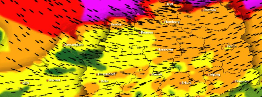
People in Germany and other parts of Northern Europe began preparations on Wednesday for a major North Sea storm that is expected to bring hurricane-strength winds to the region. The low-pressure front "Xaver" is currently on a course from Newfoundland, Canada to Europe. The storm is expected to arrive in southern Norway on Thursday before continuing towards northern Germany with gale-force winds. The storm is expected to be strongest in the north and east of the country, although rain and winds are expected in the south, too.
With gale force winds of up to 180 kilometers per hour (111 miles per hour), public officials are already bracing for what could be one of the worst storms in decades. Deutsche Bahn, Germany's national railway, is advising travelers in the states of Schleswig-Holstein, northern Lower-Saxony, Hamburg and Bremen to cancel their plans if possible. The company said it was preparing for possible disruptions to services or closures in those regions. Airports are also warning of possible delays or cancellations of flights because of the inclement weather.
Comment: The same storm system is called "Sven" in Sweden and "Bodil" in Denmark and both places are equally gearing up for a major storm.
Swedes warned: 'Expect up to 30 cm of snow'
Snow Expected at Night
The storm is expected to gain in intensity on Thursday at around noon. "In the north, we are expecting a very swift increase in wind speeds during this time," Frank Böttcher of the Institute for Weather and Climate Communication (IWK) said. By afternoon, gale force winds are expected to blow along the coasts, with winds reaching speeds of 150 kilometers per hour (93 miles per hour) in the North Frisia region. "Winds could even reach speeds of up to 180 kilometers per hour on the islands of Helgoland and Sylt," Fabian Ruhnau, a meteorologist at Meteomedia told reporters.
Extreme gale force winds are expected throughout large swaths of the country, but are likely to be particularly strong in the north and eastern regions. Winds are expected to have less force further inland, with wind speeds of up to 120 kilometers per hour (74 miles per hour) in North Rhine-Westphalia. High-speed winds are also expected along the Baltic Sea and in low mountain ranges.
In many parts of the country, the storm is expected to shift to snowfall on Thursday night. It is still unclear when Xaver will reach its maximum strength, but the German weather service DWD is predicting "a high point on Thursday night and during the early morning hours of Friday in the eastern part of the country." Other weather services are predicting the storm will reach full strength by late afternoon on Thursday.
All weather services are predicting that the storm will remain strong in all regions north of Frankfurt until well into Thursday evening. Germany's Federal Maritime and Hydrographic Agency (BSH) is also warning of potentially serious flood tides, although it said it is too early to make any definitive forecasts.
However, Hamburg-based IWK is warning that weather conditions appear to be similar to those that led to dramatic storm tides in Hamburg in 1962 that killed 340 people. This time, officials at the institute are stating, "The dikes would be able to withstand a flood of that size today."
"Xaver" is the second hurricane-force storm to hit Germany this year, following only weeks after "Christian" in October, which left seven people dead.


Which is coming along for the ride. A constantly updated tracker of lightning:
[Link]