Meteorologists use the term "atmospheric river" to describe a long, narrow plume piping deep moisture from the tropics into the mid-latitudes. One type of atmospheric river (hereafter, AR) you may have heard of is the "Pineapple Express", a pronounced plume tapping moisture from the Hawaiian Islands to the U.S. West Coast.
Amazingly, according to NOAA's Earth System Research Laboratory (ESRL), a strong AR can transport as water vapor up to 15 times the average flow of liquid water at the mouth of the Mississippi River!

© WeatheChannel.com
Suffice to say, if an AR stalls over a particular area, significant flooding can be the result. In fact, a study by Ralph et al. (2006) found ARs responsible for every flood of northern Calfornia's Russian River in a 7-year period.
That said, they're also important for western water supply considerations. According to NOAA/ESRL, 30-50% of the average annual precipitation in the West Coast states typically occurs in just a few AR events. With that in mind, one such AR is poised to soak parts of the West Coast this week. Let's get to the forecast details
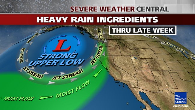
Flood Threat LoomsThe graphic at the top of this article depicts the upper-air pattern that will setup by mid-late week. Namely, a deep dip, or trough, in the jet stream will carve out over the eastern Pacific Ocean.
This will send a parade of frontal systems and upper-level disturbances into the West Coast through this weekend.
The soaking starts
Wednesday as the initial frontal system sweeps into the West Coast. This first system should be a quick mover. While rain and high-mountain snow is forecast primarily for California, but also into western Oregon and parts of western Washington, precipitation amounts Wednesday should be relatively "routine", for a Pacific frontal system in the wet season.
Then, the "atmospheric river" makes landfall.
Beginning
Thursday, the upper-level pattern will begin to tap into an atmospheric river of moisture extending from just north and west of Hawaii to the West Coast.
Most importantly, that plume of moisture won't move appreciably for a couple of days, perhaps through Sunday, aiming its firehose of moisture at northern California and, perhaps, southwest Oregon.
Therefore, some locations, particularly in the coastal ranges of northwest California and the Sierra foothills, will likely pick up over 10 inches of total rainfall through this weekend, leading to flash flooding, river flooding and, in recent burn areas, debris flows.
(INTERACTIVE:
Flood watches)
Depending on exactly where the moisture plume sets up, this heavy rain could produce significant impacts (flash flooding, rock/mudslides, etc.) in at least parts of the Bay Area, as well.
Rainfall amounts in Southern California are expected to be much lighter, with totals over the 5-day period starting Wednesday around an inch or so expected.
Heavy Snow Confined to High TerrainThis pattern will also produce heavy snow over the Sierra, not to mention parts of the Bitterroots, Tetons, and the Washington Cascades.
For Northern California our
Winter Weather Expert Tom Niziol says, "This is a relatively mild pattern, therefore snow levels will be above 6,000 to 7,000 feet for most of the time with impacts mainly at pass levels. To put this in perspective, the highest elevation of I-80 through Donner Pass is about 7,230 feet".
Niziol adds, "For the first significant system, snow will occur in the Wednesday through Thursday morning time frame there, at this point I am looking at snow totals in the range of 3 to 8 inches for the Sierra and as much as a foot around Mt Shasta. Impacts then spread north as the second system moves in Thursday through Friday bringing more precipitation, which will fall as heavy snow at elevations above 6,000 to 7000 feet across the Sierra. The Cascades through the Bitterroots will also see heavy snowfall with accumulations exceeding a foot at elevations mainly above 6000 feet."
The Shape Of Things To Come v0i11
copyright 2011 by Clif High
The supporting layers of the [north american climate alteration] descriptor set include a very ominous reference to [constant drips (en masse)] and [flowing atmospheric rivers]. The details suggest that a [continuous], or [constant], or [year round] shift into [flooding (via rainwater upstream)] has begun. The idea from the data sets is that vast areas of [canada] and [northern tier states (of the usofa)] are now the [nexus] for [manifesting conditions of precipitation]. This is suggested by the data to be due to [jet stream] and [atmospheric river channels] being [altered] in their [paths]. Further, the data sets in the [precipitation tendency] have a large number if cross links over to the SpaceGoatFarts entity where many of the termination points are within [hyperdimensional (frequency) geometry]. The detail levels within the SpaceGoatFarts entity are indicative of this [precipitation probability] being in part due to a [toroid segment shift]. {pk note: 8835}