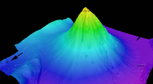
Scientists chose Kawio Barat as the first target for the expedition based on satellite information and data collected by a joint Indonesian-Australian team in 2004. The immense underwater feature served as an ideal initial target to calibrate onboard tools and technologies being used on the ships maiden voyage. Expedition scientists hope the maps and video produced from the expedition will pave the way for other researchers to follow up on their preliminary findings.
"This is a huge undersea volcano, taller than all but three or four mountains in Indonesia, and rising more than ten thousand feet from the seafloor in water more than eighteen thousand feet deep," said Jim Holden, U.S. chief scientist for the first leg of the joint expedition and a microbiologist from the University of Massachusetts in Amherst, who is operating from an Exploration Command Center in Jakarta, Indonesia. "The more we understand these undersea features and the communities of life they support, the better we can manage and protect the ocean and its resources."
In a new model of exploring the ocean through telepresence, most scientists work from shore. Holden and other scientists at the Exploration Command Centers in Jakarta and Seattle are connected to Okeanos Explorer live via satellite and high-speed Internet pathways, and can interact with shipboard personnel to guide the expedition.
Indonesian and U.S. scientists believe that investigating previously unexplored ocean areas will yield new phenomena and provide information that will improve our understanding of ocean ecosystems, ocean acidification and climate change impacts.
"Ocean-related concerns, including food security and protecting ocean ecosystems that support fisheries, affect many nations including Indonesia - a nation of 17,000 islands," said Sugiarta Wirasantosa, Indonesia's chief scientist for the joint expedition and principal investigator at Indonesia's Agency for Marine and Fishery Research. "To understand and manage such things, we must first explore. That's why this expedition is so important."

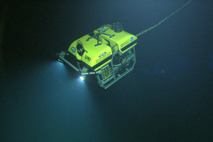
"It's very much like solving a puzzle," said Holden. "First we map the seafloor, and if we see something of interest, scientists ashore and shipboard personnel may have the ship stop to put more sensors and systems in the water. This preliminary investigation will include deploying an underwater robot called an ROV, or remotely-operated vehicle, with a pilot on the ship controlling the ROV far below. The Institute for Exploration's Little Hercules ROV is part of a two-body system that can go as deep as 13,000 feet, and when the lights and high-definition video cameras on both are turned on, it's live from the seafloor to scientists ashore."
The joint expedition is chronicled at NOAA's Ocean Explorer site with much of the site written in both English and Bahasa Indonesia. The site includes logs from scientists at sea and ashore, images from the expedition, and expedition education lesson plans aligned with U.S. National Education Teaching Standards.


Reader Comments
to our Newsletter