New Moore Island in the Sunderbans has been completely submerged.From the New York Daily News via Associated Press reports :
New Moore Island in the Sunderbans has been completely submerged. Photo - Das/AP
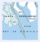
Global warming resolves 30-year land dispute between India, Bangladesh: Coveted island sinksNote in the map below that the island was a river estuary, meaning it wasn't made out of rock as claimed. It was made out of mud and sand. From Wikipedia:
By NIRMALA GEORGE, Associated Press Writer Nirmala George, Associated Press Writer - Wed Mar 24, 9:29 am ET
NEW DELHI - For nearly 30 years, India and Bangladesh have argued over control of a tiny rock island in the Bay of Bengal. Now rising sea levels have resolved the dispute for them: the island's gone.
New Moore Island in the Sunderbans has been completely submerged, said oceanographer Sugata Hazra, a professor at Jadavpur University in Calcutta. Its disappearance has been confirmed by satellite imagery and sea patrols, he said. "What these two countries could not achieve from years of talking, has been resolved by global warming," said Hazra.
The island was situated only two kilometers from the mouth of the Hariabhanga River. The emergence of the island was first discovered by an American satellite in 1974 that showed the island to have an area of 2,500 sq meters (27,000 sq ft). Later, various remote sensing surveys showed that the island had expanded gradually to an area of about 10,000 sq meters (110,000 sq ft) at low tide, including a number of ordinarily submerged shoals. The highest elevation of the island had never exceeded two meters above sea level. [1]Wikipedia Map
...
The island was claimed by both Bangladesh and India, although neither country established any permanent settlement there because of the island's geographical instability. India had reportedly hoisted the Indian flag on South Talpatti in 1981 and established a temporary base of Border Security Forces (BSF) on the island, regularly visiting with naval gunships. [3][4]
The AP claim (probably from Seth Borenstein) is that global warming induced sea level rise has submerged the island, and that is complete nonsense.
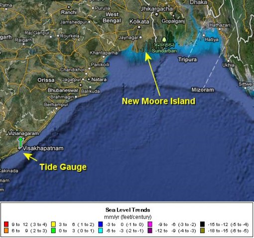
Let's look at sea level trends in the region. Here's the NOAA Tides and Currents map of the area from their interactive web site.
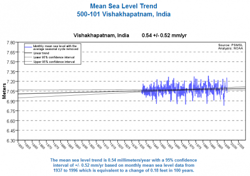
NOAA's nearest tide gauge shows sea level rising in that region at 0.54 mm / year, which means that would take nearly 2000 years for sea level to rise one meter. See the plot below:
Note that since the island was first discovered in 1974, the sea level graph above shows 19.4 mm (0.76 inches) rise based on a rate of 0.54mm/year.
Sea level rise is a relative phenomenon. It can be caused by sea rising, or land sinking. Sort of like sitting on a train at the station, and you can't tell if your train has started moving or the adjacent one.
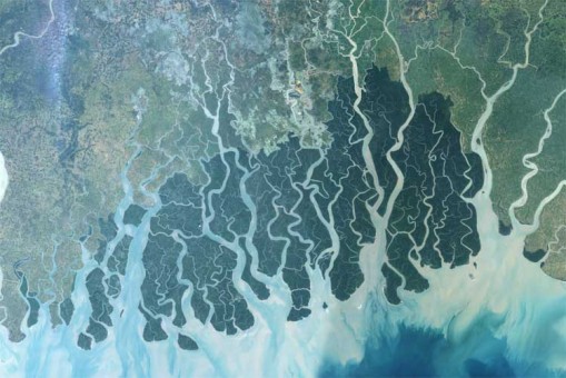
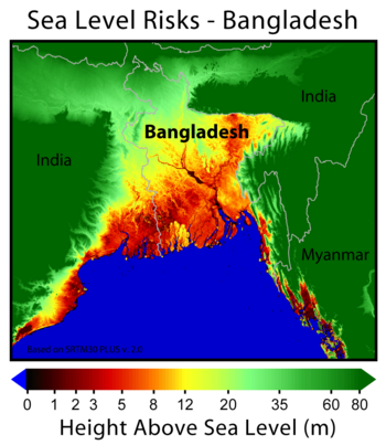
Looking at a satellite image of the Bangladesh delta, one can see how tides, currents, silts, and other factors shape what is a tenuous boundary between land and sea:
Temporary estuary islands and sandbars appear and disappear all the time worldwide. Sometimes it can take a few years, sometimes a few centuries. Note that most of the area near South Talpatti Island is only 1-3 meters above sea level anyway, which means that such low lying islands made of mud and sand are prone to the whims of tide and currents and weather.
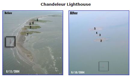
Low lying islands are modified by nature on a regular basis. For example we have Chandeleur Lighthouse in Louisiana
From USGS:
The lighthouse was situated on land until Hurricane Georges (September 28, 1998). After that the island had eroded from under the lighthouse such that the lighthouse appeared to be in open water. Since Georges, although the island had reformed behind the lighthouse, the lighthouse remained in open water. The pre-Ivan photo (August 11, 2004) shows the lighthouse in open water about 30 m from the shoreline, and the northern tip of the island was relatively broad and extended several hundred meters north of the lighthouse.And looking further back in time, islands have disappeared before: from the Sarasota Herald - May 29, 1937
...
It was probably the cumulative effect of four hurricanes in 7 years that resulted in the deep erosion (evidenced by lack of shoaling) seen now after Hurricane Ivan.
While we are on the subject of islands disappearing into the Indian Ocean, even more interesting is the 2002 discovery nearby of a 9,000 year old city, submerged 36 metres off the coast of India.
Lost city 'could rewrite history'How many Hummers were they driving 9,000 years ago? Chalk up another clueless AGW claim. Sea level rises and/or land subsides, estuary flows change, and sandbars appear and disappear. In this case of a tiny sandbar/island near the Bangladesh delta, it has nothing to do with global warming.
By BBC News Online's Tom Housden
The remains of what has been described as a huge lost city may force historians and archaeologists to radically reconsider their view of ancient human history.
Marine scientists say archaeological remains discovered 36 metres (120 feet) underwater in the Gulf of Cambay off the western coast of India could be over 9,000 years old.
The vast city - which is five miles long and two miles wide - is believed to predate the oldest known remains in the subcontinent by more than 5,000 years.


....must ever change!
I blame those profligate dinosaurs.
And while I'm on the subject, why are there no ghosts of dinosaurs?