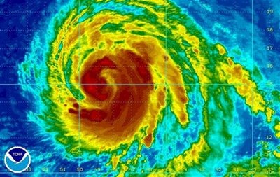
A hurricane hunter plane found that winds had increased to near 125 mph Tuesday night, making Bill a major hurricane, the first of the Atlantic season.
The National Hurricane Center says people in the Leeward Islands should monitor Bill's progress.
As of 5 p.m. Tuesday, Bill was centered about 635 miles east of the Leeward Islands, moving west-northwest near 16 mph.
The most significant threat the storm seemed to pose was to Bermuda, which it could pass in three or four days. But it also could move directly between Bermuda and the eastern coast of the U.S. without making landfall.
THIS IS A BREAKING NEWS UPDATE. Check back soon for further information. AP's earlier story is below.
Miami - Hurricane Bill strengthened far out in the Atlantic on Tuesday and forecasters said it could become a major hurricane within a day or two.
The National Hurricane Center said people in the Leeward Islands should monitor Bill's progress.
Todd Kimberlain, a forecaster at the center, said Bill is likely to become at least a Category 3 storm, which would make it the first major hurricane of the Atlantic season.
"The wind sheer is light and the waters are warm," Kimberlain said. "Those are two essential ingredients not just for the formation, but also the maintenance, of hurricanes."
As of 5 p.m. Tuesday, Bill was a Category 2 hurricane with winds near 110 mph and was centered about 635 miles east of the Leeward Islands, moving west-northwest near 16 mph.
The most significant threat the storm seemed to pose was to Bermuda, which it could pass in three or four days, Kimberlain said. But it also could move directly between Bermuda and the eastern coast of the U.S. without making landfall.
Either way, people near the coast can expect wave swells and rip currents in the next few days, Kimberlain said.
Meanwhile, people in flood-prone Haiti and the Dominican Republic awoke to good news Tuesday as it appeared Ana, the first named storm of the Atlantic season, had largely spared their shared island.
The two countries that share the island of Hispaniola are vulnerable to storms, with many impoverished people clustered along rivers, but there were no reports of major damage from the remnants of Tropical Storm Ana. The system had been downgraded to a tropical depression and then largely dissipated before reaching Haiti and the Dominican Republic. but its rains were still considered a potential threat.
"The rain fell but it did not hit anywhere very hard," said Marie Alta Jean-Baptiste, director of Haiti's civil protection department.
Haiti is particularly susceptible to catastrophic flooding because most of the trees have been stripped away to make charcoal and clear farmland and the bare, mountainous terrain cannot hold back the water. A series of storms last year killed hundreds of people and left thousands struggling to find food.
Forecasters had revised their Atlantic hurricane season predictions for this season after the first two months passed without any named storms developing.


Reader Comments
to our Newsletter