© AccuWeather
What a remarkable string of major snowstorms!
Three blizzards in a row, two for the northern Plains and one for the southern Plains. Now a fourth storm will bring snow, but no blizzard, to parts of the central and southern Plains on Wednesday night into Thursday.
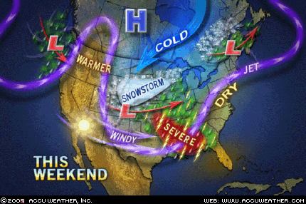
As if all this were not enough, still another storm will cut a path across the Rockies to the Great Plains, this time at week's end. It will bring snow and, at its worst, could whip up yet another blizzard.
However, one thing will be different this time. This storm will target the stretch of Plains crossed by Interstate 80, mostly over Nebraska and eastern Wyoming and it will reach south into Colorado along I-25 to at least Denver. At its worst, this storm will leave a windswept snowfall of 6-12 inches, which could be disruptive enough to interrupt travel along the major highways in this region.
Dangerous Storm Heads East Through Friday
© AccuWeather
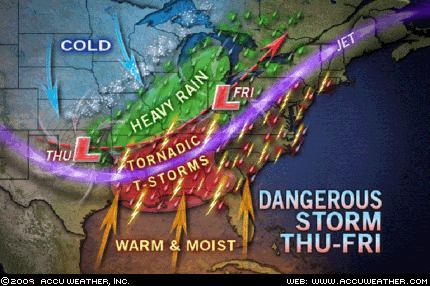
A storm emerging onto the southern Plains on Wednesday night will plow eastward Thursday and Friday. Along the way, it will produce a variety of threats to life and property from the Plains to the Eastern Seaboard.
First and foremost will be the threat of a major tornado outbreak triggered by widespread severe thunderstorms over the South and into the Ohio Valley on Thursday through Thursday night. It will likely be the biggest outbreak of tornadoes for the season thus far.
Other severe weather threats will lie with damaging straight-line winds, large hail and flooding downpours.
Heavy, potentially flooding rain will happen without the severe thunderstorms from Missouri and northwestern Arkansas to Illinois and the Lower Peninsula of Michigan.
On Friday, the parent storm will cut northeast to the eastern Great Lakes. Its rain and thunderstorms will spread over the East. Thunderstorms with damaging winds will be possible over the heart of the I-95 corridor.
Tornadoes on Thursday, Thursday Night
© AccuWeather
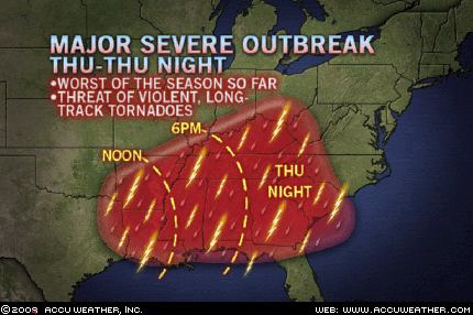
It will be the biggest outbreak of tornadoes for the year thus far.
Severe thunderstorms will erupt in a massive, far-reaching outbreak that will begin late Wednesday night with a few strong storms over Oklahoma and northern Texas. From there, it will broaden into a wide swath of powerful storms, some tornadic, barreling eastward through the lower Mississippi Valley into Alabama, Tennessee and Kentucky by late Thursday afternoon. The leading edge of severe storms will then reach southern Ohio to Georgia and South Carolina on Thursday night. Memphis, Nashville, Montgomery, Birmingham and Atlanta will be among the cities threatened by damaging thunderstorms and even tornadoes.
The tornado threat will be high across the heart of this area and will include the potential for violent, long-track twisters. There will be a significant threat of late-night tornadoes in the eastern half of the area.
Other severe threats within this wide area will stem from damaging straight-line winds, large hail and flooding downpours.


Comment: The waves and waves of cold and snow keep coming. Along with it are many spring all time record cold and record snow amounts.
You can see some of them here:
Record snowfall March 27, 2009
Record Low Minimum Temperatures March 27, 2009