|
| ©Nevada Seismological Laboratory |
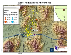
| Latest 'aftershock' map showing the original 6.0 quake which occurred on February 21, 2008 and the most recent 'aftershock'. |
Magnitude: 4.2
Date-Time: Tuesday, April 01, 2008 at 13:16:18 UTC
Tuesday, April 01, 2008 at 06:16:18 AM at epicenter
Location: 41.166°N, 114.773°W
Depth: 5 km (3.1 miles) set by location program
Region: NEVADA
Distances:
18 km (11 miles) ENE (69°) from Wells, NV
29 km (18 miles) S (184°) from Wilkins, NV
42 km (26 miles) NNW (347°) from Spruce, NV
76 km (47 miles) NW (309°) from West Wendover, NV
246 km (153 miles) WNW (282°) from Salt Lake City, UT
Location Uncertainty horizontal +/- 4.6 km (2.9 miles); depth fixed by location program
Parameters"
NST= 68, Nph= 68, Dmin=41.4 km, Rmss=1.35 sec, Gp= 32°,
M-type=body magnitude (Mb), Version=7
Source: USGS NEIC (WDCS-D)
Event ID: us2008qhav
This event has been reviewed by a seismologist.


Reader Comments
to our Newsletter