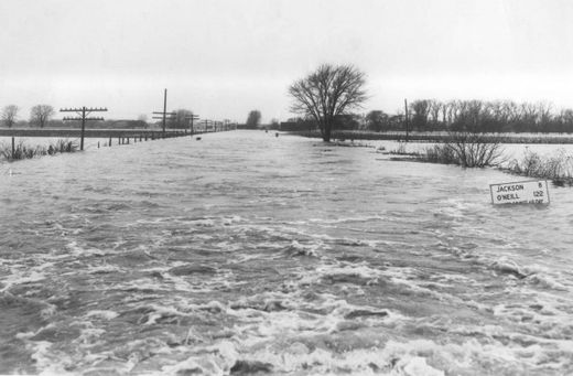
Historic flooding photo
Since the 1850s, the Mighty Missouri's flow proved instrumental to the development of Sioux City.
Riverboats plied its waters from St. Louis to Sioux City providing the goods, products and people to turn a frontier town into a thriving city on the plains. Through the years, the Missouri bit back - flooding the tri-state area numerous times and causing millions of dollars worth of damage.
By
Journal accounts, the flood of 1952 surpassed all previous records, including the historic flood of 1881.
The river reached its crest of 24.3 feet on the morning of Monday, April 14, 1952, according to
Journal stories. The swollen river easily overtook its banks, inundating North Sioux City, Sioux City, South Sioux City and points south.
By comparison, due to a series of upriver dams and channelization, the Missouri's depth in Sioux City is 28.05 as of 4 p.m. Wednesday. Flood level is 30 feet.
The Missouri River is expected to crest at 35-37 feet in the Sioux City area by the middle of June.
In 1944, Congress authorized the Pick-Sloan Flood Control Act, which built six dams and a number of reservoirs to hold water along the upper Missouri. The Gavins Point Dam near Yankton controls water releases directly above Sioux City.
The 1952 flood occurred with only one reservoir in operation -- Fort Peck near Glasgow, Montana.
"The month of March 1952 added the final stage setting for the greatest flood the upper Missouri River has ever visited upon the people of the valley since the white man settled here," Brig Gen. D. G. Shingler, Missouri River Division engineer with the Army Corps of Engineers, said in a speech on April 23, 1952.
"On the northern plains in late March lay the entire accumulation of winter snow and ice. It contained all the potentials for destructive spring floods. It needed only a sudden period of thawing high temperatures to transform the snow into flood water."
When the high water hit the tri-state area in mid April, Shingler said, "Some 600 blocks were flooded in Sioux City. Thousands of persons were evacuated, packing plants and business establishments shut down, and for two days all business was suspended by order of the Sioux City mayor. Across the river on the Nebraska side, South Sioux City was almost completely flooded, forcing some 5,000 people from their homes."
Cabins around Crystal Lake near South Sioux City flooded. Boats plied Dakota Avenue, South Sioux City's main drag. Nebraska Gov. Val Peterson dispatched four amphibious trucks to South Sioux City.
Sioux City workers built a dike around the newly built, $2 million Municipal Auditorium. It stood isolated surrounded by a sea of water.
Pilot Tommy Martin flew
Journal-Tribunes to flood-bound Pender and Wayne, Neb., after floodwaters cut off road access. Free copies were provided to people taking shelter at evacuation centers in Dakota City, Riverside and South Sioux City.
Even Queen Juliana of The Netherlands ordered a shipment of 264 canned hams, 860 boxes of cocoa, 2,800 chocolate bars and 264 tins of biscuits to be airlifted to the Red Cross from her country.
Shingler said, "From the air the Missouri flood plain from Sioux City to Omaha looked like an inland sea. Hundreds of farm dikes were smashed."
In Riverside, city inspectors red-tagged several flood-damaged houses. Most of the homes in the Stockyards area could be salvaged. Many homeowners also had to deal with backed up storm sewers in their basements.
Schools had to be closed during the height of the flood. A number of streets, railroad tracks and bridges had to be repaired.
When the floodwaters receded in the Stockyards, the sheep yard near the river bank remained under water for some time. In 1952, the sheep market was the seventh largest in the nation.
The most recent flood took place in 1993 when the river level was recorded at 26.6 feet in Sioux City, flooding some greens and riverfront homes at Dakota Dunes. The Sioux City Sue casino riverboat couldn't cruise the river because the water was too high to get under the Veterans Memorial Bridge.
That event was part of the Midwestern floods that inundated the Iowa Great Lakes, and the lands along the Missouri and then the Mississippi rivers.
Reader Comments
to our Newsletter