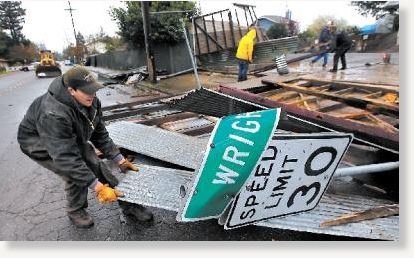
© Kent Porter / The Press Democrat
A powerful winter storm raked Northern California on Friday, unleashing a small tornado that tore the roof off a business and bringing heavy snow to the Sierra Nevada that was blamed for a fatal chain-reaction crash on Interstate 80.
The afternoon crash in the mountains 70 miles east of Sacramento involved at least six big rigs and 15 vehicles, California Highway Patrol Sgt. Curtis Fouyer said.
A man who appeared to be in his 60s was found dead, but Fouyer did not know if he was in one of the vehicles crushed by a big rig. Other motorists called police to report they were trapped but uninjured.
"They're still pulling things apart to figure out what's where and get the cars moved," Fouyer said three hours after the crash near Yuba Gap, a popular weekend sledding destination.
One victim was critically injured and 20 had moderate injuries, said Daniel Berlant, spokesman for Cal Fire.
A rain storm sliced across the Monterey Peninsula starting about 2 p.m. Monterey saw 0.66 inches of rain by 8 p.m., and a half inch fell in Salinas, said the National Weather Service. At Palo Colorado, about three miles north of the Highway 1 landslide, 0.65 inches of rain came down in about six hours.
Monterey County is expected to experience showers and a chance of thunderstorms today, with high temperatures in the mid-50s. A high surf advisory is in effect until 9 p.m.
The National Weather Service issued a flood watch for much of the Central Valley through Sunday and a winter storm warning through early today for the Sierra, where as much as 3 feet of snow was expected. Another storm expected to pack a similar wallop was forecast to hit a wider swath of the state Sunday, with high water levels projected as far south as San Diego.
Snow was reported as low as 1,200 feet just 30 miles east of the state capital, and winds up to 50 mph were expected through mountain passes. The Sierra Avalanche Center in Truckee predicted a considerable danger of snow slides.
Tree-toppling gusts of 35 to 45 mph were forecast throughout the Central Valley and Sierra foothills, putting utility crews on alert. Thunderstorms that moved through the San Francisco Bay Area were blamed for a small tornado that downed power lines and tore away a 150-foot section of a tin roof covering a landscaping business in Santa Rosa. No injuries were reported.
Meteorologist Steve Anderson said it was the first time a tornado has touched down in the area in about a decade. A tornado warning was issued briefly for San Mateo County, but the weather service had no reports of twisters.
The wet weather was expected to last through next week.
"We're kind of socked in for an unsettled wet period," said National Weather Service meteorologist Eric Kurth.
State and federal agencies were dumping more water from Northern California reservoirs to make room for mountain runoff, but officials said no major rivers were in danger of flooding. It helped that much of the precipitation was falling in the form of snow, said California Department of Resources spokesman Ted Thomas.
The U.S. Bureau of Reclamation increased the flow from Lake Shasta on the northern Sacramento River and Folsom Lake east of Sacramento. The state Department of Water Resources boosted flows from Lake Oroville 70 miles north of the state capital. As a result, Sacramento River water was spreading into the Sutter and Yolo bypasses, low-lying areas north and west of the state capital that are set aside to handle excess water and reduce the danger of flooding.
The high volume of water covered portions of parks and bicycle trails through flood plains in Sacramento and Redding. Sacramento shut flood gates at Del Paso Boulevard along the American River for the first time since 2006, requiring drivers to take a detour.
Isolated mudslides and creek flooding were expected to continue throughout the state.
The most noticeable effect of the wet weather in Northern California was along the coast, where a 150-foot section of Highway 1 south of Carmel slid toward the ocean on Wednesday. Engineers expected the two-lane coastal highway leading to scenic Big Sur to be closed at least a month after the collapse near Rocky Creek Bridge.
High water south of Sacramento will send water spilling out of Deer Creek, where a 70-year-old man was rescued earlier this week after driving his Cadillac around barriers and having it submerged by flood waters.
Rob Hartman, hydrologist in charge of the National Weather Service's California-Nevada River Forecast Center, said flooding at the mouth of the Eel River near Fernbridge, along the northern coast south of Eureka, will force farmers to move dairy cattle.
Reader Comments
to our Newsletter