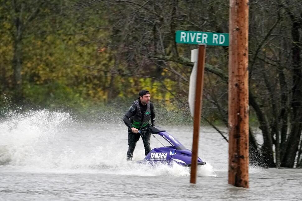
The weekend's heavy rains stemmed from the Pineapple Express, also known as an atmospheric river. The National Weather Service issued a flood watch for portions of northwest and west-central Washington, including King, Pierce and Snohomish counties.
NWS issued a wind advisory warning of southwest winds between 15 and 30 mph with gusts up to around 40 mph in Seattle, Bremerton, Tacoma and areas of the Hood Canal. The strongest winds, with gusts of up to 60 mph, were near the Strait of Juan de Fuca and the shorelines of Snohomish, Skagit and Whatcom counties thanks to a cold front passing through the region.
More than 158,000 customers were without power in Western Washington at one point Monday afternoon.
A flood warning was also issued for the Snoqualmie River near Carnation until Tuesday. The Skagit River near Mount Vernon and Concrete, and the Bogachiel River near La Push, are also expected to flood.
"There's flooding all over the place. We're looking for record flooding in those two forecast points on the Skagit River," NWS meteorologist Dana Felton said.
The Skagit River was expected to crest at an estimated record of 37.6 feet at Mount Vernon around 4 p.m. and test the city's flood wall like never before.
In 2016, the city of Mount Vernon completed construction of the flood wall to protect homes and businesses from the capricious waters of the Skagit River, which bisects its quaint downtown. Days of relentless rain have sent the river over its banks to levels not seen in more than a decade, before the wall was built, according to city and Skagit County officials.
The river was running at just under 32 feet at Mount Vernon on Monday afternoon. The wall was built to contain a flood of up to 38 feet, said Mount Vernon project manager Peter Donovan.
"That's not a lot of wiggle room," he said. "It's never been tested at that level. We are in uncharted territory."
Monday evening, the NWS reported debris in the flooded river destroyed the river gauge so river levels weren't available.
Raymond Ulrich, 39, was worried about his basement apartment, which is about a half mile away from the river.
"It's a little unsettling," he said Monday. The seven-year resident said he's never seen nonstop rain and the river so high.
If conditions worsen, Ulrich said, he will gather the two cats he adopted during the pandemic, along with valuables like his passport and an heirloom shotgun from his uncle, and stay at a friend's house. He said he hopes he won't have to use renters insurance.
"This atmospheric river needs to knock it off," he said.
The worst flooding in more than 30 years hit Whatcom County on Monday, where a state of emergency was declared Sunday evening. Residents in Everson, Nooksack and Sumas have been advised to prepare for high water and to stay home to avoid driving. Downtown Sumas was flooded Monday with all roads in and out of the town closed.
Officials closed off Interstate 5 near Bellingham in both directions overnight because of heavy flooding and active slides, according to the Washington State Department of Transportation.
Northbound I-5 was closed at Nulle Road and southbound I-5 was closed at North Lake Samish. No estimate for reopening was given Monday night with officials set to reassess closures Tuesday morning.
No detour routes were available due to continued flooding on Highway 11 and other city roads. Snow fell on Highway 2 at Stevens Pass, with up to 9 inches expected to fall by Tuesday morning.
While worsening snow conditions and continued rising waters are expected north, NWS said conditions won't be nearly as extreme in the coming days in the Seattle area.
"It will be a much tamer day," meteorologist Logan Johnson said about Tuesday.
There could be a few showers in the morning, but after that expect sun breaks and highs in the 50s, he said. Wednesday and Thursday will likely be a little cooler, with highs in the upper 40s, but it will be mostly dry and partly sunny as well.
That's a green light for Emily Alhadeff, a Seattle-based editor and writer who moved to the region 11 years ago from Connecticut.
One of her most important rainy season adaptations has been attitude and action, she said.
"As soon is the sun is out, I feel like I have to get outside now!" she said. Her husband, who is from Seattle, will sometimes want to watch a movie on such days, but she cannot abide the idea.
"It's like, 'No, we can't waste it. Who knows when it will come again. Carpe Diem!' "
Adrienne Kafka, 23, who moved to Seattle in August, is also adapting.
She said she's not surprised at all by the number of gray, rainy days we've had so far this year, but she has been a little taken aback by how heavy the storms and deluges can be. A continuous "light spritzing" is what she was told to expect, she said.
Seattle Times staff reporters Daisy Zavala and Amanda Zhou contributed to this report.


That's near future, as we enter Winter almost 90% of the USA will be crippled with freezing temperatures and disruptive snowfall.