The derecho, a widespread weather system with a long line of storms packing high winds, descended upon the Central U.S. on Monday with wind speeds comparable to a major hurricane as it spent several hours tearing through parts of Iowa, Nebraska and Wisconsin.
The storm likely caused more widespread damage than a normal tornado, said Patrick Marsh, science support chief at the National Weather Service´s Storm Prediction Center in Norman, Oklahoma.
It´s not quite a hurricane. It has no eye and its winds come across in a line. But the damage it is likely to spread over such a large area is more like an inland hurricane than a quick more powerful tornado, Marsh said.
He compared it to a devastating Super Derecho of 2009, which was one of the strongest on record and traveled more than 1,000 miles in 24 hours, causing $500 million in damage, widespread power outages and several deaths.
The weather service´s Marsh said there´s a huge concern about power outages that will be widespread across several states and long lasting. Add high heat, people with medical conditions that require power and the pandemic, 'it becomes dire pretty quickly.'
In Iowa, roadways were littered with downed power lines as semi-trailer trucks were blown over and entire grain elevators demolished in the agriculture-heavy state.
Wind speeds in Nebraska topped 70 mph as massive trees crashed into residential homes.
Special Marine Warnings were issued in Wisconsin as the potential for water spouts was discovered in Lake Michigan.
The National Weather Service has issued a vast number of severe weather warnings throughout Monday to a number of cities.
From 6 to 7pm, the agency released more than 20 of such warnings in at least four states, including Missouri, Illinois, Kansas, Oklahoma, Indiana and Michigan.
PowerOutage.us reports that more than 1,130,505 Americans are without power due to the powerful derecho as of Monday at 7pm.
Illinois has the highest number of customers without power at 570,756, while Iowa followed closely behind with 491,260.
'This is our version of a hurricane,' Northern Illinois University meteorology professor Victor Gensini said in an interview from his home about 15 minutes before the storm was about to hit.
Minutes later he headed to his basement for safety as the storm took aim at Chicago, starting with its suburbs.
Gensini said this derecho will go down as one of the strongest in recent history and be one of the nation's worst weather events of 2020.
'They are basically self-sustaining amoebas of thunderstorms,' Gensini said. 'Once they get going like they did across Iowa, it's really hard to stop these suckers.'
'It ramped up pretty quick' around 7 a.m. Central time in Eastern Nebraska. I don't think anybody expected widespread winds approaching 100, 110 mph,' Patrick Marsh said.
Several people were injured and widespread property damage was reported in Marshall County in central Iowa after 100 mph winds swept through the area, said its homeland security coordinator Kim Elder.
She said the winds blew over trees, ripped road signs out of the ground and tore roofs off of buildings, including the roof of a hockey arena in Des Moines.
'We had quite a few people trapped in buildings and cars,' she said. She said the extent of injuries is unknown and that no fatalities have been reported.
Elder said some people reported their cars flipping over from the wind, having power lines fall on them and getting injured when hit by flying debris. Dozens of cars at one factory had their windshields blown out. Buildings have also caught on fire, she said.
'We´re in life-saving mode right now,' Elder said.
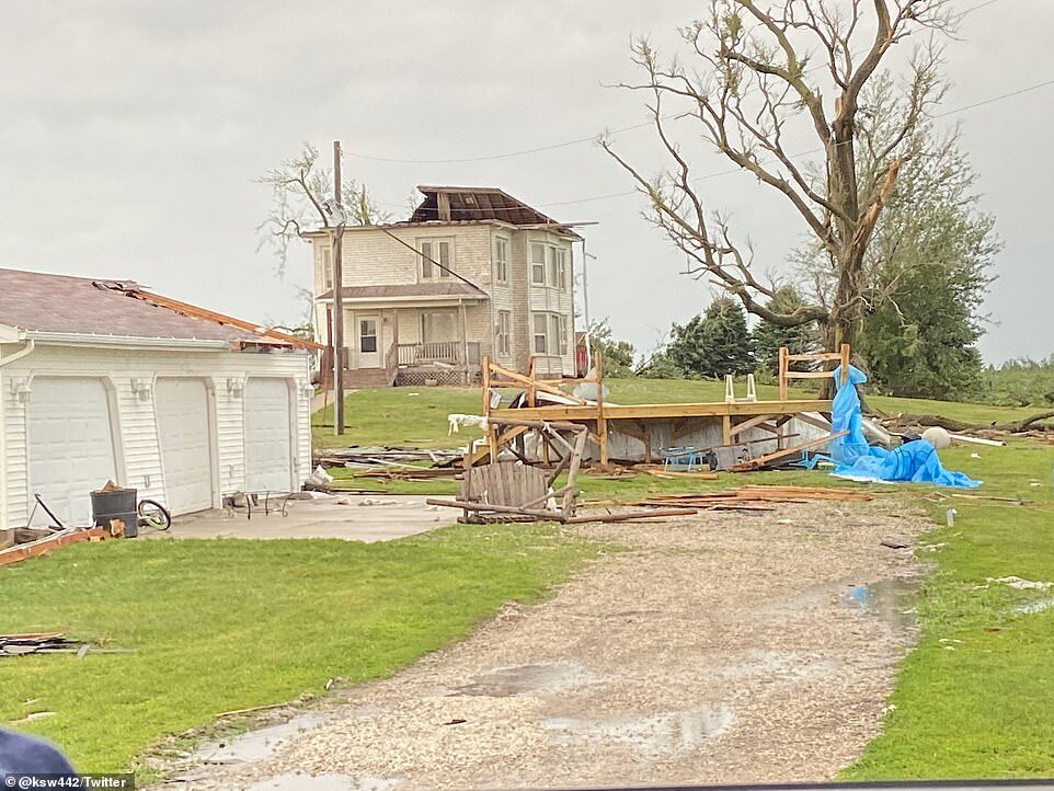
Photos shared by Des Moines residents show a city inundated by powerful gusts of winds that leveled several buildings and structures.
Vehicles and entire RVs were capsized onto their sides, a wooden outdoor patio was reduced to nothing more than wooden planks and a number of farms sustained damage.
A video shared by one Iowa resident showed a downed semi-trailer truck on a highway slick with rain. The truck, which was downed by mighty gusts of wind, had its emergency lights flashing as only a handful Iowans who braved the storm drove by.
The resident said her son and father helped the truck driver out of the vehicle and waited at the scene until emergency crews arrived. The driver is okay and no severe injuries were reported.
The Iowa Department of Transportation shared another photo of the semi-trailer truck and cautioned residents to avoid traveling during the derecho.
Farmers reported that some grain bins were destroyed and fields were flattened, but the extent of damage to Iowa's agriculture industry wasn´t immediately clear.
One farm door that measured 24'x18' was reportedly ripped off its hinges during the storm and was found more than 200 yards away.
In Collins, one woman's farm was pulled apart as two grain bins and seven hoop buildings were hit. She added that she would need to round up 800 farm pigs and find them new homes.
Marshalltown Mayor Joel Greer declared a civil emergency, telling residents to stay home and off the streets so that first responders can respond to calls.
Travel advisories were issued in the cities of Ankeny, Johnston, Boone and Perry, as well.

MidAmerican spokeswoman Tina Hoffman said downed trees are making it difficult in some locations for workers to get to the power lines. In some cases power line poles were snapped off.
'It´s a lot of tree damage. Very high winds. It will be a significant effort to get through it all and get everybody back on,' she said. 'It was a big front that went all the way through the state.'
Cedar Rapids, Iowa, has 'both significant and widespread damage throughout the city,' said public safety spokesman Greg Buelow.
'We have damage to homes and businesses, including siding and roofs damaged,' he said. 'Trees and power lines are down throughout the entire city.'
Buelow said residents should stay home so crews can respond to 'potentially life-threatening calls.' Tens of thousands of people in the metro area were without power.
In Nebraska, the storms raced east before 9am, dropping heavy rains and high winds. Strong straight-line winds pushed south into areas that include Lincoln and Omaha, National Weather Service meteorologist Brian Barjenbruch said.
'Once that rain-cooled air hit the ground, it surged over 100 miles, sending incredibly strong winds over the area,' Barjenbruch said.
Omaha Public Power District reported more than 55,500 customers without power in Omaha and surrounding communities. Several cities are still under Hazardous Weather Outlook advisories.
'There is a slight chance for an isolated storm in the overnight hours tonight in far southeast Nebraska. Localized heavy rain would be the primary threat,' the National Weather Service wrote.
From Tuesday to Sunday, 'There is a chance for storm activity on Wednesday and Thursday. Severe potential will be limited,' in Nebraska.
A summary of the derecho's affect on Nebraska showed that the city of Bennington had the highest wind speeds at 77mph, followed by Little Sioux at 70mph.
Much of the area experienced widespread tree damage, especially in 'orange shaded areas.'
A severe thunderstorm warning was issued in Omaha, but it was dismissed later in the day as the storm rolled out of the state and into Illinois.
What makes a derecho worse than a tornado is how long it can hover one place and how large an area the high winds hit, Marsh said. He said winds of 80 mph or even 100 mph can stretch for '20, 30, 40 or God forbid 100 miles.'
'Right now, it´s making a beeline for Chicago,' Marsh said Monday mid-afternoon. 'Whether or not it will hold its intensity as it reaches Chicago remains to be seen.'
But the environmental conditions between the storm and Chicago are the type that won´t likely diminish the storm, Marsh said. It will likely dissipate over central or eastern Indiana, he said.
But as of Monday evening, Chicago has been inundated with strong winds, persistent rain and several instances of property damage.
The damage that came with the derecho followed vandalism from Sunday night as scores of Chicagoans looted stores downtown.
The long night saw more than 100 arrests, attacks on 13 police officers and widespread unrest.
Cars plowed through storefronts to give the crowds easy access and despite there being 400 officers dispatched to the area, the cops struggled to keep up with the crowds.
One officer was attacked with a bottle, another had his nose broken and a group of different officers were shot at by drive-by assailants while trying to arrest other looters. On Monday morning, police were still arresting people at a Best Buy which was among the stores that had been ransacked. Some of the city's bridges were raised and tunnels were closed while police tried to regain control of the situation.
'It was still a rather impressive storm,' weather service meteorologist Bryan Leatherwood told the Chicago Tribune.
'We're getting tons of reports of downed large trees and power lines down, and debris thrown through the walls of houses.'
Footage shared by the agency showed wind lifting pieces of debris into the air at a Chicago park after a tornado warning was implemented.
One Chicago resident shared a photo of the storm floating over the city, with ominous dark clouds shrouding downtown buildings.
Winds up to 100mph sent debris and trees from a Chicago farm 200 to 300 yards into the field.
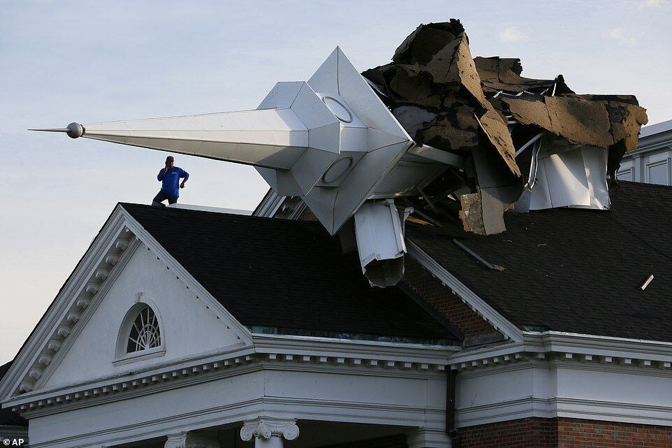
A building under construction partially collapsed during the storm and a steeple on College Church, near Wheaton College, collapsed.
In Lincoln Park, a large tree was pushed over by the wind and fell atop a parked van.
Lucas Seiler told the Chicago Tribune he had just arrived home and views a tornado warning on his phone when the incident happened.
'I heard this crackling noise, and down came a huge tree which I loved,' said Seiler. 'It's massive. You can see the roots tore up the brick that was on the ground.'
In Naperville, more than than 300 homes had to be restored with power and the city's transportation lines were having service disruptions.
At 4pm, the National Weather Service warned residents that wind gusts speeds were increasing in several areas. The Aurora Airport in Sugar Grove recorded 54 mph and DuPage Airport found gusting up to 60mph.
A forecast predicts that the rain will disappear mid-week before returning on Friday and Saturday for the weekend.
Associated Press


Comment: Severe storms bring tennis ball-size hail, damaging winds, torrential rain to Minneapolis - Saint Paul