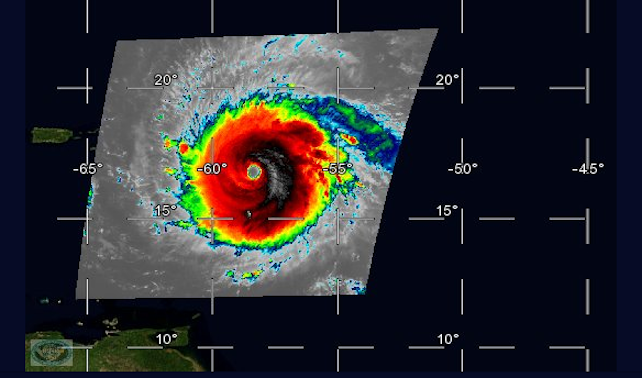
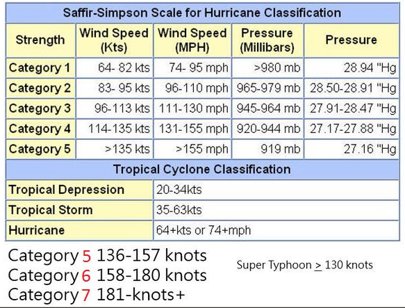
Dr. Ryan Maue said this morning:
Hurricane #Irma is still intensifying. Now up to 155-knots (180 mph) Extrapolating Saffir-Simpson scale, 158-knots would be Category 6.NWS says: (bold mine)
Hurricane Irma Discussion Number 26
NWS National Hurricane Center Miami FL AL112017
1100 AM AST Tue Sep 05 2017
Irma is an extremely impressive hurricane in both infrared and visible satellite images. Experimental GOES-16 one-minute visible satellite pictures show a distinct 25-30 n mi wide eye with several mesovortices rotating within with eye. The aircraft have not sampled the northeastern eyewall where the strongest winds were measured shortly before 1200 UTC this morning, but the Air Force plane will be entering the eye in that quadrant momentarily. A peak SFMR wind of 154 kt was reported, with a few others of 149-150 kt. Based on these data the initial intensity is set at 155 kt for this advisory. This makes Irma the strongest hurricane in the Atlantic basin outside of the Caribbean Sea and Gulf of Mexico in the NHC records.


Reader Comments
R.C.