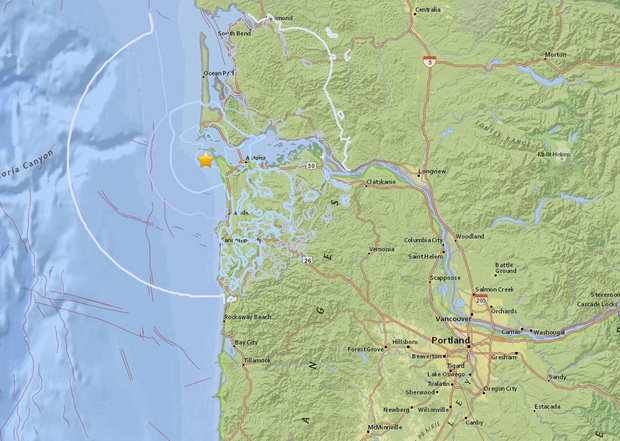
Callers told NATU News the quake rattled their homes, shaking items hanging or on shelves and moving things around. Twitter users reported feeling the quake for a radius extending several miles.
According to the USGS mapping tool, the 7:52 a.m. quake was centered near the coast about 10 miles west of Astoria at a depth of around 21 miles.
The USGS intensity map indicates the quake, naturally, was much stronger near its center by the coast, and its effect weakened in areas farther inland.
The quake was not a Cascadia Subduction Zone earthquake, and instead an isolated event on one of the numerous other faults in Oregon and Washington, USGS officials said.
They added that earthquakes must be magnitude 7.0 or above to create a tsunami.
REPORTS
Several people reported jolts that moved their "whole building," waking them up and knocking over various belongings.
A man calling from Hammond said the whole thing was over quickly -- but was still unnerving, saying he was ready to "get in the car and go" after his wife woke him up screaming.
Other reports said it sounded like a strong windstorm, rattling the house for several seconds, or like a tree had fallen nearby.
A Warrenton woman said she stood in a doorway to wait for the shaking to stop after what felt like a large object hitting the whole house.
PLANNED SEISMIC TOUR
The quake couldn't have hit at a more opportune time, as Gov. Kate Brown was scheduled to take a midday seismic readiness tour in the area, beginning in Astoria.
"For me it's just a wake up call. Keep working, keep planning, preparing where it's happening," said Gov. Brown.
Her plans included a stop at the Clatsop County Emergency Operations Center and the Clatsop Community College Seismic Resilience & Preparedness Tour.
It's taken about ten years to get a building on the campus ready for a full-blown quake. Preparedness is something Adam Phelps of the Office of Emergency Management says is a never-ending process.
"Governor, I hope I never tell you we're fully prepared. As soon as I say that there is something else we find we need to be doing," said Phelps.
Emergency planners say it's best to have what you need for the first two minutes, for the first two days, and for two weeks. Adam said a lot of people haven't thought that far out from a disaster.
"Who has that, who actually has that? So it's a big concern about being prepared. And having readiness," said Phelps.


Comment: The really big one: The next full Cascadia rupture will spell the worst natural disaster in North American history