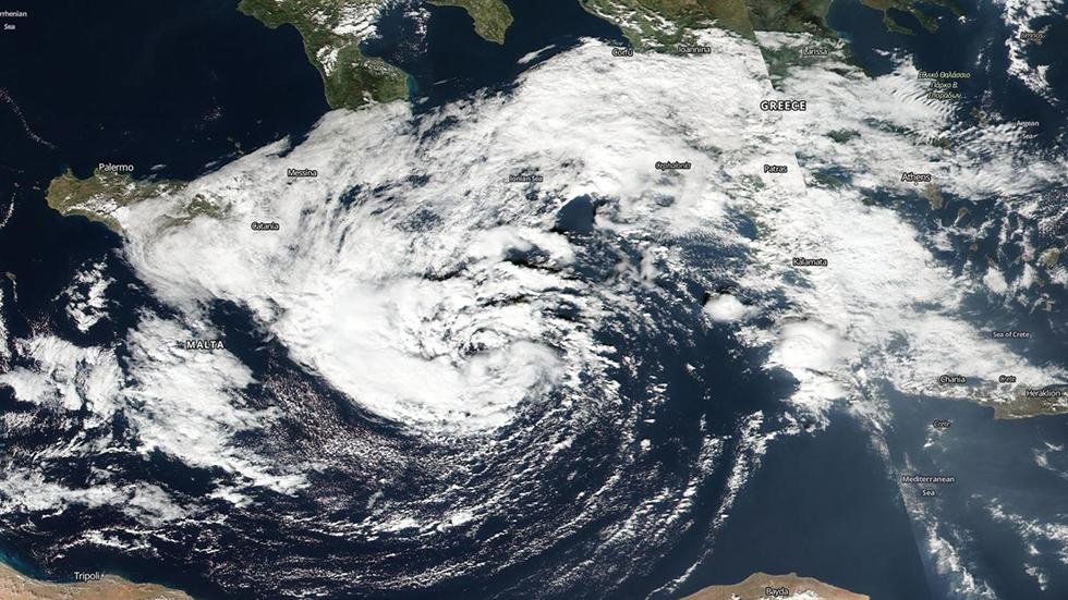
This rather strange sequence of events began as an area of low-pressure dropped southward from southern Europe and became temporarily left behind by the jet stream over the central Mediterranean Sea south of the Italian coast.
By Saturday, Oct. 29, a non-tropical low pressure center formed east of Malta, a group of islands between Sicily and the coast of Libya over the weekend.
The next day, thunderstorms became more clustered near the low-pressure center to warm the mid levels of the atmosphere sufficiently to morph the system into a subtropical storm.
A subtropical storm displays features of both tropical and non-tropical systems, including a broad wind field, no cold or warm fronts, and generally low-topped thunderstorms displaced from the center of the system.
Soon after, the clusters of storms became even more tightly concentrated, and the atmosphere warm enough that this low actually became a tropical storm.
This Mediterranean tropical storm, known as invest 90M, wasn't nearly the powerhouse deep tropical cyclone you would see in the tropical Atlantic or Pacific basins.
Its warm air was relatively shallow, but there, according to an analysis from Florida State University.
This storm whipped up impressive waves on the coast of Malta.
By later on Oct. 31, the tropical storm was finally whipped eastward by an arriving jet stream, becoming a non-tropical low again as it brushed southern Greece and Crete.
Are 'Medicanes' Real Hurricanes?
In the meteorological community, there is some debate whether past vigorous low-pressure centers over the Mediterranean Sea were truly tropical cyclones, or a combination of a tropical and more typical mid-latitude low-pressure center, known as a subtropical cyclone.
In fact, they can become strong enough to be considered Mediterranean hurricanes, or "Medicanes". They can form in late summer or fall and also in winter and early spring.
One argument for "Medicanes" is the appearance of some recent storms via satellite resembling small hurricanes, including an eye.
The most vivid recent example of this was in January 1995. National Hurricane Center senior hurricane specialist Dr. Jack Beven chronicled this impressive storm, including satellite imagery.
In early November 2011, another low over the Mediterranean Sea appeared to transition to at least a subtropical storm, if not a tropical storm. NOAA/NESDIS designated this tropical storm 01M, also Rolf, on Nov. 7.
Weather Underground's Dr. Jeff Masters, however, notes that water temperatures near the cyclone were cold, about 63 degrees Fahrenheit (17C), well below the typical threshold needed to maintain a tropical cyclone, which usually about 79 degrees.
Nevertheless, the storm made landfall in southeast France, produced up to 2 feet of rain, triggered major flooding in parts of France, Spain and Italy. Twelve were killed.
With the storm over the weekend, surface water temperatures were much warmer, around 24 degrees Celsius, but still generally cooler than what typically supports tropical cyclone formation in the Atlantic Basin.
In a warming world, could Medicanes become more common?
Masters' blog cites a 2007 study by Gaertner et al., purporting hurricanes could form in the Mediterranean Sea if sea-surface temperatures rose by 3 degrees Celsius by 2100.
Masters also points out three main barriers to strong medicanes in the future:
- The jet stream still typically dips southward over the Mediterranean Sea quite often, given its northern latitude.
- The key to tropical cyclone formation in other basins is the depth of warm water available, not just warmth at the surface. The Mediterranean Sea is not supplied with deep, warm water like the western Atlantic Ocean is from the Gulf Stream.
- Various island and land masses jutting out (Italy, Sicily, Corsica, Sardinia, Greece) would disrupt the circulation.


Plane crash, dead fish, earthquake & now a storm. Did the storm form anywhere near the location of the quake?