The earliest forming Central Pacific hurricane this year could be the first to cross the equator this season
If you were looking for a location that defined the term 'the middle of nowhere', Johnston Atoll would have a strong claim.
This uninhabited island lies 1,390 kilometres southwest of the Hawaiian Islands, themselves lying in a remote part of the Pacific.
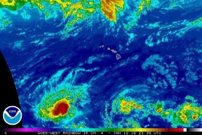
Johnston Atoll is mentioned here because it is the closest island to what has already become a noteworthy cyclone, Hurricane Pali.
Pali is currently a Category 2 storm (on the five-point Saffir-Simpson scale), with sustained winds of 157 kilometres an hour and gusts of 195km/h.
It is unlikely to affect any inhabited islands in this part of the Pacific, and can truly be described as a 'fish storm'.
Nevertheless, Pali has already gone down in history: On Monday, it became the earliest-forming hurricane in either the Central or Northeastern Pacific - the area between the International Dateline and the Americas.
This is 19 days earlier than the previous record holder, Ekeka in 1992. These two cyclones are the only ones to have formed in this region before May.
This may well be due to the ongoing El Nino weather pattern, one of the strongest on record.
Another notable feature about Pali is that it has formed unusually close to the equator, currently lying just five degrees to the north. It is even possible that it could cross the equator, the first time such an event would have been observed in this region.
#Pali (now south of 6N) is the most equatorward a hurricane has existed on record in the Western Hemisphere. pic.twitter.com/aqyKPKgekw
— Philip Klotzbach (@philklotzbach) January 13, 2016Certainly, Pali will drift closer to the equator in the coming days, driven there by an area of high pressure to the north.
Pali's track remains highly unpredictable, as there is little precedent for such an early cyclone at such low latitudes.
The current prediction from the US Joint Typhoon Warning Centre is for Pali to maintain its strength for several days, as it continues to draw energy from the warm waters of that part of the Pacific (28 to 29C).


Reader Comments
to our Newsletter