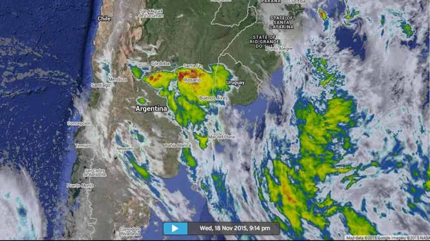
Hail up to the size of tennis balls pelted parts of Córdoba and Santa Fe provinces, west and northwest of the Argentine capital of Buenos Aires on Wednesday.
Impresionante el tamaño del #granizo en San Jeronimo Sud en Santa Fe #Argentina Video pic.twitter.com/ZtO8Ff4kBn
— Met Uy Estacion bcp (@Estacion_bcp) November 19, 2015Social media photos showed vehicles covered in dents, windshields smashed, homes with damaged shutters and roofs in Santa Fe province. The hail was enough to cover the grass. An eerie hail fog lingered after the storm passed in some places.
FLASH | Novas imagens do granizo destrutivo na província argentina de Santa Fé. pic.twitter.com/hmHmNYN8UC
— MetSul Meteorologia (@metsul) November 18, 2015If that wasn't enough, a tornado was spawned in Córdoba province Wednesday.
#Tornado flagrado em #Sampacho, #Córdoba, #Argentina (Crédito do vídeo: Reprodução/Meteo Tube) pic.twitter.com/BfBHlS6VLj
— De Olho No Tempo (@deolhonotempo) November 19, 2015This cluster of severe thunderstorms then pushed northeastward into far southern Brazil early Thursday morning, downing utility poles and damaging homes in the town of Uruguaiana.
Flooding along the Rio Uruguay in São Borja and Uruguaiana affected 1,160 residents, Rádio Guaíba reported.
The culprit to this was a strong jet-stream level disturbance pivoting east swinging east over warmer, more humid air ahead of cold front driving east across northern Argentina into Paraguay, far southern Brazil and Uruguay.
In his book The Rough Guide to Weather, Weather Underground blogger Bob Henson says large hail is a perennial threat in and around the Sierras de Córdoba, a mountain range just west of the city of Córdoba, Argentina.
Henson says strong afternoon thunderstorms may occur every 3-4 days in and near the city, dumping heavy rain and hail.


Comment: Just over one week ago more apocalyptic weather pounded parts of Argentina.