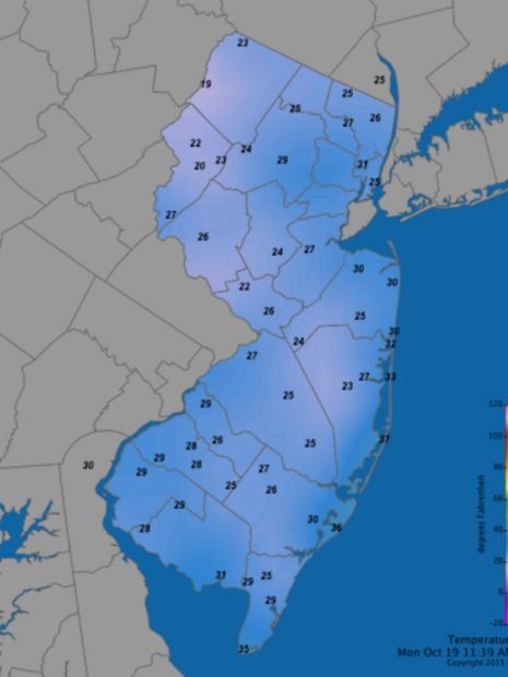
The mercury plunged to 27 degrees in Trenton on Monday, shattering the previous record low for Oct. 19: 30 degrees set in 1986 and 1974, according to the National Weather Service's Mount Holly Office.
In Atlantic City, the temperature dropped to 28 and it was the coldest morning in October since Halloween in 2011, according to the weather service.
Locally, the mercury sank to 23 degrees in Berkeley, 24 in Upper Freehold and 25 in Howell, according to the New Jersey Weather and Climate Network.
The cold led to a widespread freeze in the entire region covered by the Mount Holly Office, according to a forecast discussion. In some cases, it was a hard freeze, with temperatures of 28 degrees or lower.
"As a result, the growing season has now ended for the entire region," the discussion says.
On Sunday, I drove from Pittsford, New York, to New Jersey and encountered snow showers on the New York State Thruway. Good thing the highway didn't seem slippery, at least when and where I was driving
Fortunately (or unfortunately if you love cold weather), it's expected to warm up in New Jersey this week, according to the weather service. Temperatures are forecast to hit the balmy 70s in Freehold on Wednesday and Thursday.
But with winter looming, here's another winter forecast, this time from Steven DiMartino, meteorologist and owner of NY NJ PA Weather:
- A strong El Nino (warming in the tropical Pacific Ocean that is strong right now but expected to weaken), convection this fall and a positive Pacific Decadal Oscillation (a very warm body of water in the Gulf of Alaska down the West Coast) "suggest a rather stormy weather pattern along the Gulf Coast, Tennessee River Valley, Southeast, and Mid Atlantic."
- Very cold water in the northwestern Atlantic and well above normal water temperatures along the East Coast may lead to a high threat for nor'easters (Miller A and B types). Miller A nor'easters form primarily on the Gulf Coast or East Coast. Miller B storms come in from the west (up the Ohio Valley), with low pressure redeveloping along the East Coast, according to the weather service.
- Overall, much of the Northeast and mid-Atlantic, including New Jersey, would see stormy weather with near-normal temperatures.


Winter in the NW shows signs it too is coming early. El Nino is looking for a place to dump, and it's no secret what it's favorite target is. It is also known to be rather vindictive, making fools out of 'Experts'. Especially those who like to gainsay it's power to erase dry spells at the flick of it's swirling wrists.
The Earth's Weather and Climate does not answer to Man, nor does it pay any regard to his Theories concerning it.
All Man really knows about it is how it has recently and historically behaved, much to his chagrin and dismay.