Koppu developed into a typhoon early Friday morning local time and strengthened through the end of the week, reaching super typhoon status late Saturday evening. With wind gusts up to 295 km/h (180 mph), Koppu intensity was similar to that of a Category 4 hurricane in the Atlantic Ocean.
Very early Sunday morning, Koppu made landfall near Casiguran, Aurora on the eastern coastline of Luzon as a very dangerous cyclone the equivalent of a Category 4 hurricane. Koppu has weakened and is no longer a super typhoon, but still poses a significant threat to those in the Philippines.
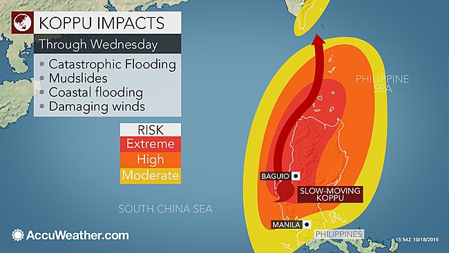
In addition to Koppu's increased strength as it approached the Philippines, the system also has slowed down significantly. The combination of a powerful and slow-moving typhoon spells a disastrous situation for residents and communities in its path across northern Luzon.
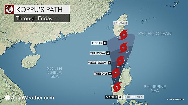
Koppu crawled toward towards northern Luzon Island throughout the day Saturday, local time, making landfall early Sunday morning. Koppu is expected to move slowly northward along the west coast of Luzon through the first half of the week. While the threat for damaging wind will decrease during this time, life-threatening flooding will remain a major concern.
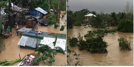
breaking news: flashfloods sa brgy.san isidro,san luis,aurora pic.twitter.com/jc9kILFtEF
— Dennis Cabral Datu (@Dennis_Datu) October 18, 2015In Baguio, over 200 mm (8 inches) of rain had already fell by Sunday evening. The city could receive another 250 mm (10 inches) of rain before Koppu pulls away.
"A total of 300 to 600 mm (12 to 24 inches) of rain is expected to be widespread," AccuWeather Meteorologist Adam Douty said. There will even be localized amounts upwards or in excess of 900 mm (36 inches). Such rain is sure to trigger severe and life-threatening flooding and mudslides.
"The most significant rain will fall in the mountainous terrain of northern Luzon," Douty added.
Residents in Baguio, Sagada, Candon, Vigan City analog City are among areas that will continue to see heavy rain through Tuesday. Heed all evacuation orders and begin making plans to seek shelter away from areas prone to flooding and mudslides.
Streams and rivers will quickly turn into raging waterways and flood neighboring homes and land, roads and bridges can get cut off and low-lying communities could get turned into lakes.
Koppu will stay far enough to the north for Manila to escape the worst of the impacts; however, heavy rain may push into the city and surrounding areas through Monday. During this time there will be a heightened risk for flash flooding. However, significant flooding should not be an issue.
Impacts from Koppu will not be limited to the Philippines. Taiwan, Japan and far eastern China remain on alert for potential hazards later this week. "By Wednesday, we should see Koppu slowly begin to pull to the north and impacts in Taiwan should gradually increase," stated Douty.
While there remains some uncertainty in the track as Koppu drifts to the north during the second half of the week, there is growing confidence that locally heavy rain will fall in eastern Taiwan.
AccuWeather Meteorologists think that greatest threat for flooding across Taiwan will occur in the eastern part of the island. however, depending on the exact track of Koppu, there could still be locally heavy rain and gusty wind in western parts of the country as well.
Showers and thunderstorms could also advance westward into southeastern China later in the week, but at this time, life-threatening impacts are not expected. Once Koppu moves further to the north it will encounter stronger wind shear near Taiwan and the South East China Sea which will cause the storm to weaken significantly. Because of this, if there are impacts to Japan they will not be significant.
Behind Koppu is Champi, which strengthened into a super typhoon in the western Pacific Basin on late on Sunday, local time. Champi crossed the Northern Mariana Islands on Friday with wind gusts around 130 km/h (80 mph). While Saipan was battered by Champi, Guam was far enough south to miss the worst of the cyclone. Even so, wind gusts of 65-80 km/h (40-50 mph) were common along with downpours.
The latest indications point toward this system then curving to the north, then northeast well away from Japan. However, Iwo Jima will be in the path of this typhoon around the middle of the week. If Champi maintains its strength, damaging wind and flooding rain will blast across the small island.
Content contributed by AccuWeather's Senior Meteorologist Kristina Pydynowski and Meteorologist Courtney Spamer.


Reader Comments