Tropical Storm Ana was nearing hurricane strength mid-day on Oct. 17 and the Central Pacific Hurricane Center (CPHC) expects the storm to become a hurricane before reaching the big island of Hawaii.
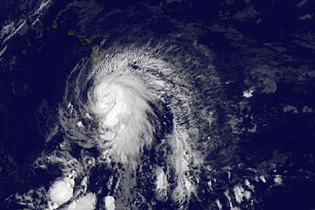
NOAA's GOES-West satellite took an infrared picture of Tropical Storm Ana as it was approaching Hawaii on Oct. 17 at 11 a.m. EDT (5 a.m. HST). Ana looked like a giant question mark in the infrared image, as a large band of thunderstorms wrapped into the center from the eastern side of the storm and extended south of the storm.
Despite the storm looking like a question mark from space, the Central Pacific Hurricane Center said that there is no question the storm has been intensifying.
A Tropical Storm Watch remained in effect for Hawaii County on Oct. 17. A tropical storm watch means that tropical storm conditions are possible within the watch area, in this case within 24 to 36 hours. Interests elsewhere in the main Hawaiian Islands, and in the Papahanaumokuakea Marine National Monument Area, should monitor the progress of Ana.
The CPHC expects tropical-storm-force winds to affect the Big Island of Hawaii by tonight, Oct. 17. In addition, heavy rainfall with total rain accumulations between 6 and 8 inches, with isolated totals of 12 inches are possible. Heavy rain could potentially affect the other islands Saturday and Sunday. This rainfall could cause life-threatening flash floods and mud slides.
In addition to the winds and heavy rainfall, dangerous surf will precede and Ana. CPHC noted that large swells are expected to build over the eastern end of the main Hawaiian island chain today (Oct. 17) through Saturday. These large swells will continue to spread up the island chain through the weekend. Surf produced by these swells could potentially be damaging along exposed south and southeast shorelines beginning later today and Saturday, and persisting through the weekend in some areas.
At 11 a.m. EDT (5 a.m. HST) maximum sustained winds were near 70 mph (110 kph) and Ana is expected to become a hurricane later in the day with gradual weakening expected Saturday and Sunday. The center of tropical storm Ana was located near latitude 15.7 north, longitude 154.2 west. Ana was moving toward the west-northwest near 14 mph (22 kph)
Ana is expected to turn slightly to the northwest and slow over the weekend of Oct. 18 and 19. After a brief stint as a hurricane overnight Oct.17 and early Oct. 18 when it will be west of the Big Island, it is expected to weaken back to a tropical storm and move almost parallel to the Hawaiian Islands while remaining over water, west of the islands. By mid-week next week, around Oct. 18, the CPHC expects Ana to track through the French Frigate Shoals.


Reader Comments
to our Newsletter