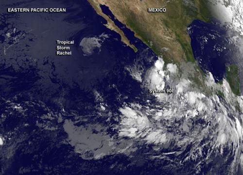
NOAA's GOES-West satellite captured an image of the Eastern Pacific Ocean on Sept. 30 at 1200 UTC (8 a.m. EDT). In the infrared image, Tropical Storm Rachel appeared small in comparison to the low pressure area called System 90E, coming together hundreds of miles south. As Rachel spins down over cool waters west of Baja California, Mexico, southwesterly wind shear was obvious in the GOES-West image because the bulk of Rachel's clouds had been pushed to the north. The image was created by NASA/NOAA's GOES Project at the NASA Goddard Space Flight Center in Greenbelt, Maryland.
The National Hurricane Center (NHC) noted that Rachel was still maintaining tropical storm strength on Sept. 30 at 5 a.m. EDT, when maximum sustained winds were near 40 mph (65 kph). Rachel was centered near 23.3 north latitude and 117.5 west longitude, about 485 miles (780 km) west of the southern tip of Baja California. Rachel was stationary at the time.
NHC forecasters expect that southwesterly wind shear affecting Rachel to become even stronger, more than 30 knots, within a day or so. That means that the storm will weaken and the forecast calls for Rachel to degenerate into a remnant low by Wednesday, Oct. 1.
As Rachel weakens, an elongated area of low pressure called System 90E continues to consolidate a few hundred miles south of Acapulco, Mexico. The NHC noted that environmental conditions are favorable for a tropical depression to form later this week while the system moves toward the west-northwest or northwest near 10 mph.
Because System 90E is so close to the coast, it is expected to produce locally heavy rains over portions of southern Mexico that could cause flash flooding and mud slides.
Over the next two days, System 90E has a 50 percent chance of becoming a tropical depression and that chance skyrockets to 90 percent by day five.


Reader Comments
to our Newsletter