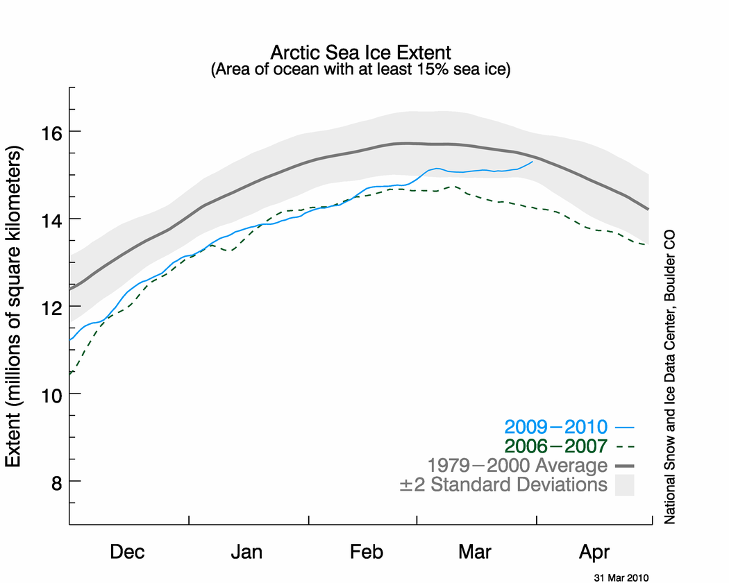
Barring an about face by nature or adjustments, it appears that for the first time since 2001, Arctic Sea ice will hit the "normal" line as defined by the National Snow and Ice Data Center (NSIDC) for this time of year.
NSIDC puts out an article about once a month called the Sea Ice News. It generally highlights any bad news they can find about the disappearance of Arctic ice. Last month's news led with this sentence.
In February, Arctic sea ice extent continued to track below the average, and near the levels observed for February 2007.But March brought good news for the Polar Bears, and bad news for the Catlin Expedition and any others looking for bad news. Instead of ice extent declining through March like it usually does, it continued to increase through the month and is now at the high (so far) for the year.
If it keeps this trend unabated, in a day or two it will likely cross the "normal" line.
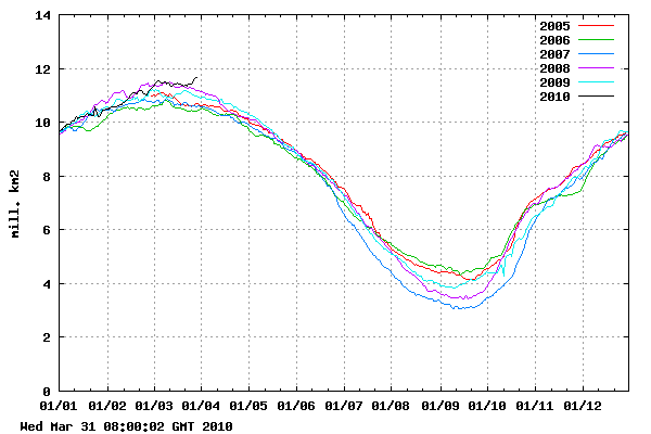
The Danish Meteorological Institute shows Arctic ice extent at the highest level in their six year record.
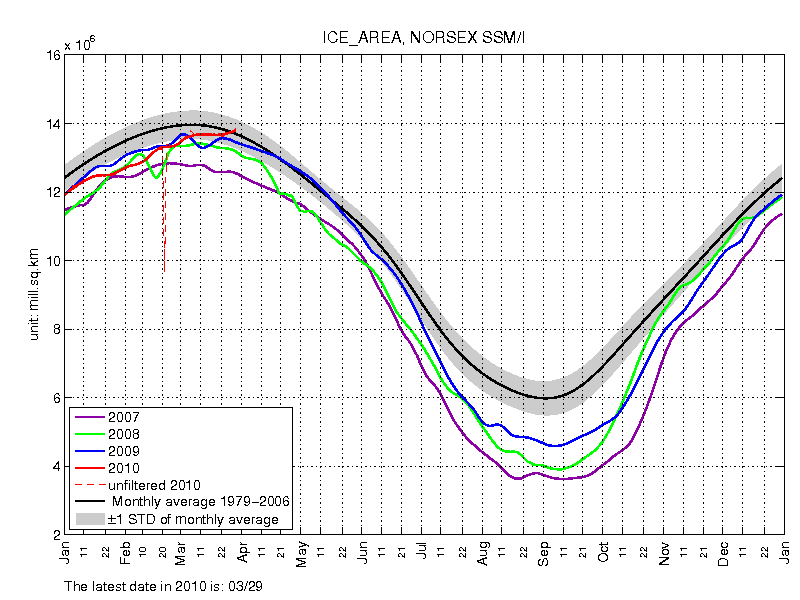
The Norwegians (NORSEX) show Arctic ice area above the 30 year mean.
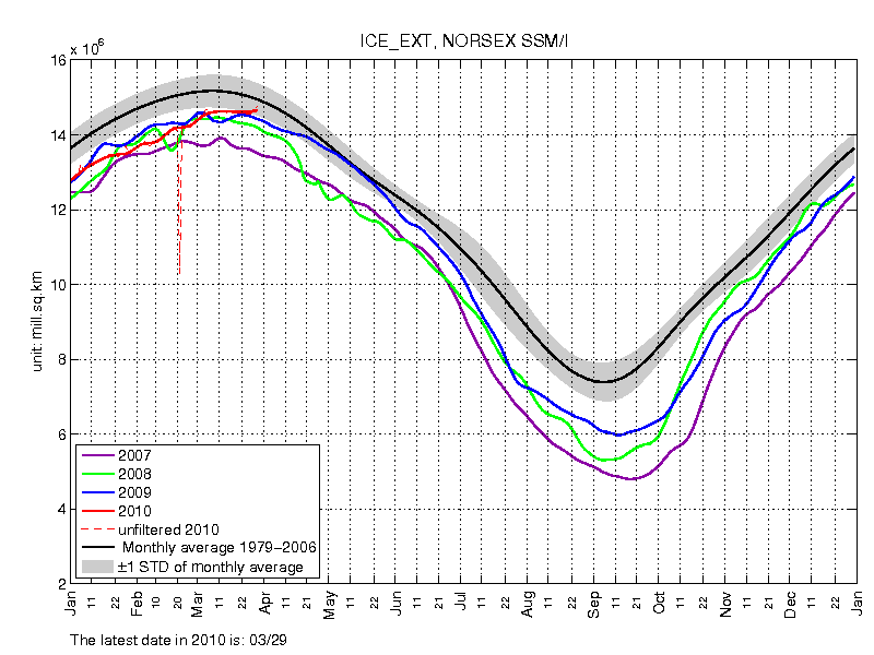
And the NORSEX Ice Extent is not far behind, within 1 standard deviation, and similar to NSIDC's presentation. Note that is hit normal last year, but later.
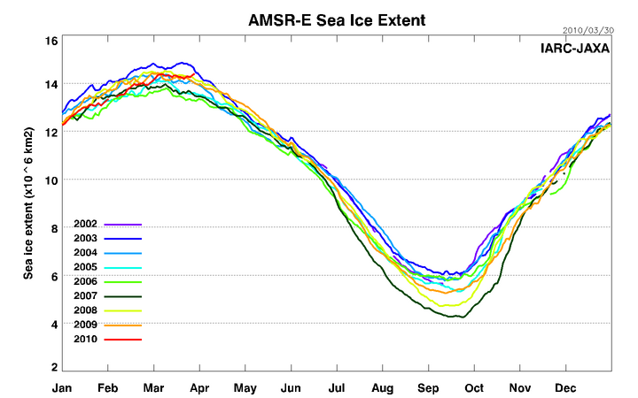
And JAXA, using the more advanced AMSR-E sensor platform on the AQUA satellite, shows a similar uptick now intersecting the 2003 data line.
WUWT asked NSIDC scientist Dr. Walt Meir about this event to which he responded via email:
It's a good question about the last time we've been above average. It was May 2001. April-May is the period when you're starting to get into the peak of the melt season for the regions outside of the Arctic Ocean (Bering Sea, Hudson Bay) and the extent tends to have lower variability compared to other parts of the year as that thinner ice tends to go about the same time of year due to the solar heating. Even last year, we came fairly close to the average in early May.He also mused about a cause:
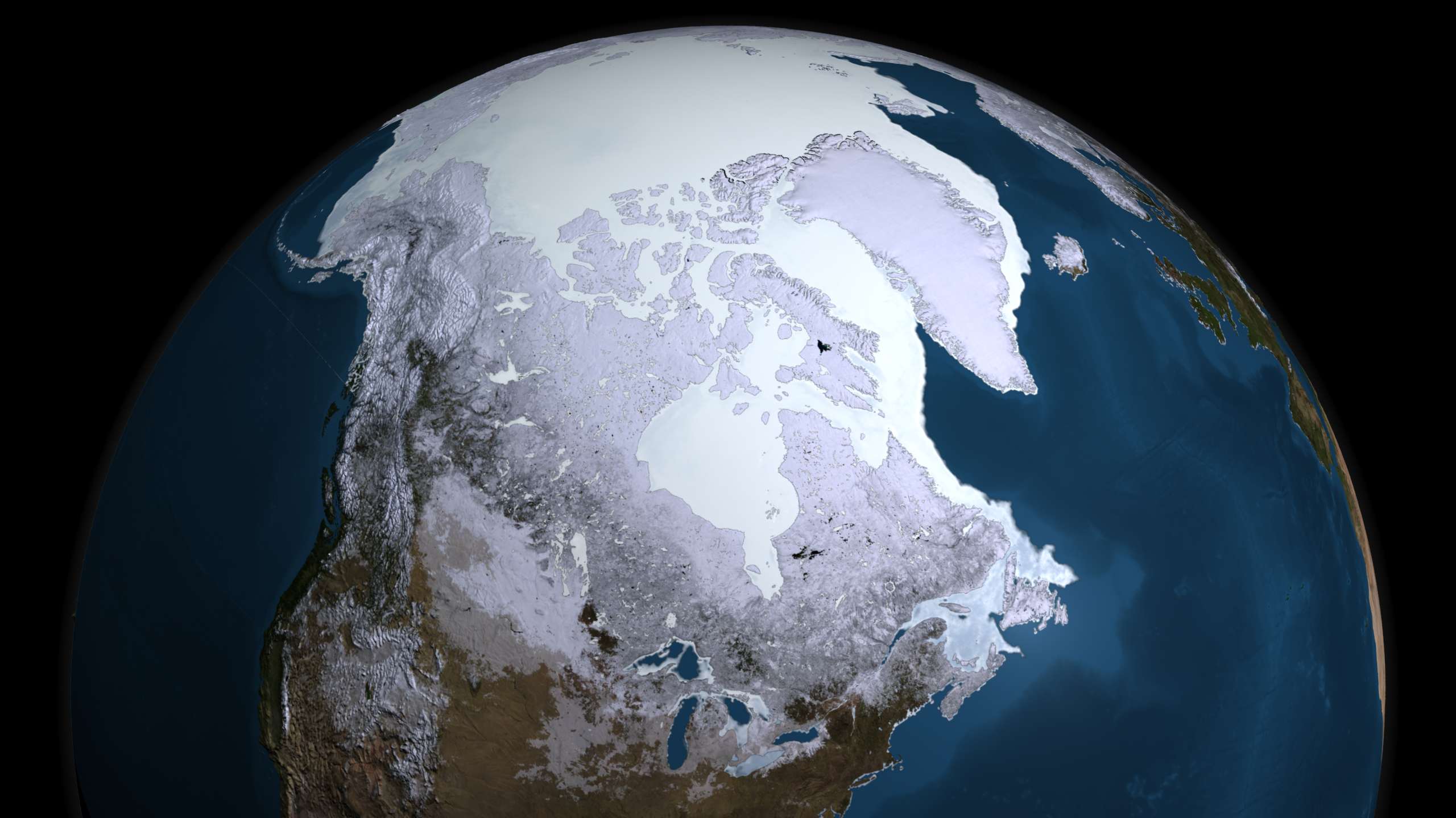
Basically, it is due primarily to a lot more ice in the Bering Sea, as is evident in the images. The Bering ice is controlled largely by local winds, temperatures are not as important (though of course it still need to be at or at least near freezing to have ice an area for any length of time). We've seen a lot of northerly winds this winter in the Bering, particularly the last couple of weeks.As we've been saying on WUWT for quite some time, wind seems to be a more powerful factor in recent sea ice declines than temperature. Recent studies agree.
See: Winds are Dominant Cause of Greenland and West Antarctic Ice Sheet Losses and also NASA Sees Arctic Ocean Circulation Do an About-Face
You can watch wind patterns in this time lapse animation, note how the ice has been pushed by winds and flowing down the east coast of Greenland:
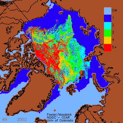
Dr. Meier also wrote:
This has very little implication for what will happen this summer, or for the long-term trends, since the Bering Sea ice is thin and will melt completely well before the peak summer season.There's certainly no reason to disagree with the idea that much of the Bering Sea ice will melt this summer, it happens every year and has for millenia. But with a strong negative Arctic Oscillation this year, and a change in the wind, it is yet to be determined if Arctic Sea ice minimum for 2010 is anomalously low, and/or delayed from the usual time.
In 2009, WUWT noted it on September 15th: Arctic sea ice melt appears to have turned the corner for 2009
Dr. Mark Serreze of NSIDC offered some hopeful commentary in a press release back on October 6th 2009, but still pushes that "ice free summer" meme:
"It's nice to see a little recovery over the past couple of years, but there's no reason to think that we're headed back to conditions seen in the 1970s," said NSIDC Director Mark Serreze, also a professor in CU-Boulder's geography department. "We still expect to see ice-free summers sometime in the next few decades."Remember this 2007 prediction from The Naval Postgraduate School?
Arctic summers ice-free 'by 2013′Joe Romm wrote up a clever piece last year on this subject:
By Jonathan Amos
Science reporter, BBC News, San Francisco
Scientists in the US have presented one of the most dramatic forecasts yet for the disappearance of Arctic sea ice.
Their latest modelling studies indicate northern polar waters could be ice-free in summers within just 5-6 years.
Professor Wieslaw Maslowski told an American Geophysical Union meeting that previous projections had underestimated the processes now driving ice loss.
Summer melting this year reduced the ice cover to 4.13 million sq km, the smallest ever extent in modern times.
Remarkably, this stunning low point was not even incorporated into the model runs of Professor Maslowski and his team, which used data sets from 1979 to 2004 to constrain their future projections.
"Our projection of 2013 for the removal of ice in summer is not accounting for the last two minima, in 2005 and 2007," the researcher from the Naval Postgraduate School, Monterey, California, explained to the BBC."So given that fact, you can argue that may be our projection of 2013 is already too conservative."
"In the end, it will just melt away quite suddenly," said Professor Peter Wadhams.
Exclusive: New NSIDC director Serreze explains the "death spiral" of Arctic ice, brushes off the "breathtaking ignorance" of blogs like WattsUpWithThat.So now that Arctic ice has returned to normal extent and area, we eagerly await the explanation from the experts about how that fits into the "death spiral" theory. Richard Feynman famously said "Science is the belief in the ignorance of the experts."
June 5, 2009
I interviewed by email Dr. Mark Serreze, recently named director of The National Snow and Ice Data Center. Partly I wanted him to explain his "death spiral" metaphor for Arctic ice.
Time will tell. 2010 is looking promising for sea ice recovery again. After all, who wouldn't want the Arctic Sea ice to recover? WUWT is predicting a recovery again this year, which we started mentioning as a prediction last fall.
So given what we know today, what will NSIDC highlight in their April Sea Ice News?


Reader Comments
to our Newsletter