|
|
Signs Supplement: Climate
and Earth Changes
September 2005
-
Don't miss our Hurricane
Katrina Special! -
SHANGHAI - China evacuated more
than 790,000 people as powerful Typhoon Talim slammed
into its east coast after barreling across Taiwan, where
it left three dead and dozens injured.
Talim was forecast to be the strongest storm to hit China
this season and the observatory in Fujian province issued
its highest-level alert, warning of potential landslides,
flooding and widespread damage.
With a radius of 250 kilometres (155 miles), Talim was packing
centre winds of up to 144 kilometres (86 miles) per hour on
Thursday, according to the central weather bureau in Taiwan.
The China Meteorological Association said the storm made landfall
at Putian city in Fujian late afternoon, bringing torrential
rain and strong winds.
State television showed rising seas off the coast of Fujian
as rains hammered coastal roads, but winds did not appear as
strong as they were in Taiwan where three people died and 59
were injured on Wednesday and Thursday.
Nearly 500,000 people have been evacuated in Fujian and another
291,000 from neighbouring Zhejiang province, according to local
officials, while some 30,000 fishing vessels returned to harbour.
Most flights from Fujian's capital Fuzhou were cancelled Thursday
and schools province-wide have been ordered to close until
Monday, state television said.
Talim is "probably the strongest typhoon China will experience
in terms of wind this summer,"
said National Meteorological Centre expert Zhang Ling.
Wang Dongfa, head of Zhejiang's meteorological bureau, said
they expect the typhoon to focus on Fujian but nevertheless
warned of torrential rain to Wenzhou, Taizhou and Ningbo cities
and surrounding areas.
East and southeast China are prone to typhoons and have been
pummeled by dozens over the past 50 years.
Talim churned through Taiwan Wednesday but by late Thursday
had largely left the island as it churned toward China.
Two men drowned in southern Tainan and northern Miaoli counties
while a 60-year-old woman was hit by lightning in the southern
Changhua county, the National Fire Agency said.
Offices, schools and financial markets closed in Taiwan, all
domestic flights were canceled and many trains and international
air services were delayed.
An air raid drill slated for Friday in Taipei was postponed
until next week.
Electricity was cut to 1.7 million homes
but most were expected to be reconnected before the end of
the day.
In Taichung, a bridge connecting Kukuan, a popular hot spring,
was submerged by flash floods, prompting the evacuation of
hundreds of tourists.
In the northeastern county of Ilan, powerful waves smashed
into the port of Wushi which was closed by the authorities.
Among those injured were eight prisoners and a policeman,
hurt when their van rammed a crash barrier.
In the capital, where the rain and winds were less severe
than elsewhere, bars, karaoke lounges and restaurants were
crowded as people took advantage of the national holiday declared
as a result of Talim.
Most air and land traffic was expected to return to normal
later Thursday as the typhoon moved away. |
Ophelia
threatens Florida
Tropical storm heads toward state's eastern coast |
CNN
Wednesday, September 7, 2005; Posted: 5:35 a.m. EDT |
Freshly named Tropical Storm Ophelia was
moving slowly toward the northeastern Atlantic coast of Florida
on Wednesday, forecasters said, threatening to drench the state
with up to 8 inches of rain in some areas, possibly within
24 hours.
Ophelia intensified to a tropical storm early Wednesday,
with maximum sustained winds of near 40 mph and higher gusts.
As of 5 a.m. Wednesday, the storm's center was located about
105 miles east of Cape Canaveral, Florida. It was moving
north-northwest at near 8 mph and was expected to continue
in that direction, slow down and possibly strengthen slightly
within the next 24 hours.
Tropical storm warnings are posted from Sebastian Inlet, Florida,
northward to Flagler Beach, Florida, the Miami-based National
Hurricane Center said. The warning means tropical storm conditions,
including winds of at least 39 mph, are expected in the area
within the next 24 hours.
A tropical storm watch, meaning tropical storm conditions
are possible within the next 36 hours, was in effect from north
of Flagler Beach to Fernandina Beach, Florida, forecasters
said.
Rainfall of 3 to 5 inches with isolated amounts of up to 8
inches are expected across portions of central and northern
Florida and southeastern Georgia as a result of Ophelia. In
addition, dangerous surf conditions and rip currents will be
possible along the southeastern U.S. coast from the Carolinas
southward to Florida.
Meanwhile, Tropical Storm Nate -- which initially was forecast
to pose no threat to land -- is now on track to pass near or
just south of Bermuda later this week, forecasters said Wednesday.
The Bermuda Weather Service has issued a tropical storm watch
for the Atlantic island. Nate's maximum sustained winds were
near 70 mph with higher gusts Wednesday -- just shy of hurricane
force.
At 5 a.m. ET Wednesday, the center of the storm was located
about 260 miles south-southwest of Bermuda. It was moving toward
the northwest at about 2 mph, and was expected to turn toward
the north or north-northeast later Wednesday and Thursday.
"On the forecast track, Nate is forecast to pass near
or just south of Bermuda Thursday night or Friday morning," said
the Miami-based National Hurricane Center.
The storm was expected to strengthen during
the next 24 hours, and Nate could become a hurricane later
Wednesday, forecasters said. |
S 517 IS
109th CONGRESS
1st Session
S. 517
To establish the Weather Modification Operations and
Research Board, and for other purposes.
IN THE SENATE OF THE UNITED STATES
March 3, 2005
Mrs. HUTCHISON introduced the following bill; which was read
twice and referred to the Committee on Commerce, Science, and
Transportation
A BILL
To establish the Weather Modification Operations and
Research Board, and for other purposes.
Be it enacted by the Senate and House of Representatives
of the United States of America in Congress assembled,
SECTION 1. SHORT TITLE.
This Act may be cited as the 'Weather Modification Research
and Technology Transfer Authorization Act of 2005'.
SEC. 2. PURPOSE.
It is the purpose of this Act to
develop and implement a comprehensive and coordinated
national weather modification policy and a national
cooperative Federal and State program of weather modification
research and development.
SEC. 3. DEFINITIONS.
In this Act:
(1) BOARD- The term 'Board' means the Weather Modification
Advisory and Research Board.
(2) EXECUTIVE DIRECTOR- The term 'Executive Director' means
the Executive Director of the Weather Modification Advisory
and Research Board.
(3) RESEARCH AND DEVELOPMENT- The term 'research and development'
means theoretical analysis, exploration, experimentation,
and the extension of investigative findings and theories
of scientific or technical nature into practical application
for experimental and demonstration purposes, including the
experimental production and testing of models, devices, equipment,
materials, and processes.
(4) WEATHER MODIFICATION- The term 'weather modification'
means changing or controlling, or attempting to change or
control, by artificial methods the natural development of
atmospheric cloud forms or precipitation forms which occur
in the troposphere.
SEC. 4. WEATHER MODIFICATION
ADVISORY AND RESEARCH BOARD ESTABLISHED.
(a) IN GENERAL- There is established in the Department
of Commerce the Weather Modification Advisory and Research
Board.
(b) MEMBERSHIP-
(1) IN GENERAL- The Board shall consist of 11 members
appointed by the Secretary of Commerce, of whom--
(A) at least 1 shall be a representative of the American
Meteorological Society;
(B) at least 1 shall be a representative of the American
Society of Civil Engineers;
(C) at least 1 shall be a representative of the National
Academy of Sciences;
(D) at least 1 shall be a representative of the National
Center for Atmospheric Research of the National Science
Foundation;
(E) at least 2 shall be representatives of the National
Oceanic and Atmospheric Administration of the Department
of Commerce;
(F) at least 1 shall be a representative of institutions
of higher education or research institutes; and
(G) at least 1 shall be a representative of a State
that is currently supporting operational weather modification
projects.
(2) TENURE- A member of the Board serves at the pleasure
of the Secretary of Commerce.
(3) VACANCIES- Any vacancy on the Board shall be filled
in the same manner as the original appointment.
(b) ADVISORY COMMITTEES- The Board may establish advisory
committees to advise the Board and to make recommendations
to the Board concerning legislation, policies, administration,
research, and other matters.
(c) INITIAL MEETING- Not later than 30 days after the date
on which all members of the Board have been appointed, the
Board shall hold its first meeting.
(d) MEETINGS- The Board shall meet at the call of the Chair.
(e) QUORUM- A majority of the members of the Board shall
constitute a quorum, but a lesser number of members may hold
hearings.
(f) CHAIR AND VICE CHAIR- The Board shall select a Chair
and Vice Chair from among its members.
SEC. 5. DUTIES OF THE BOARD.
(a) PROMOTION OF RESEARCH AND DEVELOPMENT- In order to
assist in expanding the theoretical and practical knowledge
of weather modification, the Board shall promote and fund
research and development, studies, and investigations with
respect to--
(1) improved forecast and decision-making technologies
for weather modification operations, including tailored
computer workstations and software and new observation
systems with remote sensors; and
(2) assessments and evaluations
of the efficacy of weather modification, both purposeful
(including cloud-seeding operations) and inadvertent
(including downwind effects and anthropogenic effects).
(b) FINANCIAL ASSISTANCE- Unless the use of the money is
restricted or subject to any limitations provided by law,
the Board shall use amounts in the Weather Modification Research
and Development Fund--
(1) to pay its expenses in the administration of this
Act, and
(2) to provide for research and development with respect
to weather modifications by grants to, or contracts or
cooperative arrangements, with public or private agencies.
(c) REPORT- The Board shall submit to the Secretary biennially
a report on its findings and research results.
SEC. 6. POWERS OF THE BOARD.
(a) STUDIES, INVESTIGATIONS, AND HEARINGS- The Board
may make any studies or investigations, obtain any information,
and hold any hearings necessary or proper to administer
or enforce this Act or any rules or orders issued under
this Act.
(b) PERSONNEL- The Board may employ, as provided for in
appropriations Acts, an Executive Director and other support
staff necessary to perform duties and functions under this
Act.
(c) COOPERATION WITH OTHER AGENCIES- The Board may cooperate
with public or private agencies to promote the purposes of
this Act.
(d) COOPERATIVE AGREEMENTS- The Board may enter into cooperative
agreements with the head of any department or agency of the
United States, an appropriate official of any State or political
subdivision of a State, or an appropriate official of any
private or public agency or organization for conducting weather
modification activities or cloud-seeding operations.
(e) CONDUCT AND CONTRACTS FOR RESEARCH AND DEVELOPMENT-
The Executive Director, with the approval of the Board, may
conduct and may contract for research and development activities
relating to the purposes of this section.
SEC. 7. COOPERATION WITH THE
WEATHER MODIFICATION OPERATIONS AND RESEARCH BOARD.
The heads of the departments and agencies of the United States
and the heads of any other public or private agencies and institutions
that receive research funds from the United States shall, to
the extent possible, give full support and cooperation to the
Board and to initiate independent research and development
programs that address weather modifications.
SEC. 8. FUNDING.
(a) IN GENERAL- There is established within the Treasury
of the United States the Weather Modification Research
and Development Fund, which shall consist of amounts appropriated
pursuant to subsection (b) or received by the Board under
subsection (c).
(b) AUTHORIZATION OF APPROPRIATIONS- There
is authorized to be appropriated to the Board for the purposes
of carrying out the provisions of this Act $10,000,000
for each of fiscal years 2005 through 2014. Any
sums appropriated under this subsection shall remain available,
without fiscal year limitation, until expended.
(c) GIFTS- The Board may accept, use, and dispose of gifts
or donations of services or property.
SEC. 9. EFFECTIVE DATE.
This Act shall take effect on October
1, 2005. |
TOKYO - Japan braced for another hit by
a powerful typhoon that battered the southern island of Kyushu
and parts of South Korea, leaving at least 17 people dead and
several others missing.
Officials said 10 people were unaccounted for after Typhoon
Nabi set off landslides, forcing the cancellation of more
than 1,000 flights and disrupting Prime Minister Junichiro
Koizumi's re-election campaign schedule.
Police said at least 98 people were injured, 20 of them seriously.
In South Korea, five people were also reported missing.
"It was such a large amount of rain and lasted for such
a long time. There was more damage than we expected," said
a police spokesman in worst-hit Miyazaki prefecture, where
eight died and more than 300 homes damaged.
"The major rivers in Miyazaki were about to burst. Had
they done so, the damage would have been even greater,"
he said.
Nabi worked a slow path over the southern island of Kyushu,
including Miyazaki, on Tuesday before heading onto the Sea
of Japan (East Sea).
But on Wednesday it was shifting back northeast,
threatening the northern island of Hokkaido which is rarely
hit by typhoons.
Four days ahead of Sunday's general election, Koizumi took
a break from campaigning to hold a meeting with disaster authorities
to review preparations.
"We will make decisions as we look at the entire situation" of
typhoon damages, the disaster management minister, Yoshitaka
Murata, told reporters after meeting with Koizumi.
Rescue workers on Kyushu used long, metal rods to feel under
piles of mud for any buried victims.
In the rural town of Tarumi, rescuers found the bodies of
two elderly women in their 70s at a house that was engulfed
by a landslide. Another dead woman had been found in the house
Tuesday.
In western Yamaguchi prefecture, a landslide collapsed a section
of a highway, burying three people who were inside two houses.
Residents of Hokkaido were warned of heavy rain, strong winds
and high waves, with Nabi expected to hit the island by Thursday,
the meteorological agency said.
The typhoon caused the cancellation of 136 domestic flights
Wednesday, after a total of 894 flights were cancelled on Tuesday,
according to public broadcaster NHK.
As of 1100 GMT, Nabi was above the sea 240 kilometers (150
miles) west of Oga peninsula in northern Akita prefecture,
the meteorological agency said.
Packing winds of up to 90 kilometers (56 miles) per hour,
Nabi was moving northeast at 50 kilometers (31 miles) per hour,
it said.
Mainland Japan was struck by a record 10
typhoons last year. One of them, Tokage, was the deadliest
in a quarter-century, killing 90 people.
In South Korea, an 18-year-old student was missing after heavy
rains sent here car into a river, police said.
Floods also swept away a 70-year-old man and three other people
went missing overnight in South Korea, Yonhap news agency reported.
About 1,000 people fled their homes in the South Korean city
of Ulsan and nearby cities. The typhoon grounded 100 domestic
and international flights. |
TOKYO - Powerful typhoon Nabi left Japan
after crisscrossing north to south in a path of destruction
that left 32 dead or missing in Japan and South Korea and flooded
thousands of homes.
The typhoon headed onto the Sea of Okhotsk east of Siberia
nearly a week after it first built up in the subtropical
Pacific waters south of Japan.
The worst hit area remained Miyazaki province on the southern
island of Kyushu, where rice fields were deluged by a powerful
downpour.
"We found another body, believed to be a 28-year-old
man who had gone missing, in a rice field" flooded by
the typhoon, an official at Miyazaki prefectural police said.
It has raised the death toll in Japan to 19, with at least
eight others still missing. The search was also on for five
people who are unaccounted for in South Korea.
With the typhoon bringing violent rains to most of the country,
police said 139 people had been injured in 30 of Japan's 47
prefectures.
After hitting Kyushu, the typhoon made a sharp turn to the
east, slamming into the northern island of Hokkaido but bypassing
Japan's central population hubs.
Television footage showed residents in Hokkaido, which is
rarely hit by typhoons, using buckets to bail water from their
flooded houses as high waves lashed the coast.
"We have not received reports of injuries or deaths over
the typhoon ... but we need to be on alert,"
a Hokkaido police official said, noting waves were still high
and rivers were swollen.
Nabi, which means "butterly" in Korean, was 300
kilometers north of Abashiri City on Hokkaido's Okhotsk coast
at 10:00 am (0100 GMT) and is forecast to weaken into a temperate
depression later Thursday.
At its height, the typhoon packed winds of more than 90 kilometers
(56 miles) an hour across a radius of nearly 300 kilometers,
a greater area than Hurricane Katrina which ravaged New Orleans.
The typhoon flooded more than 8,000 houses,
triggered 155 landslides and damaged 80 roads since the weekend,
Japanese police said.
The disaster also indirectly hit Japan's election on Sunday,
with Prime Minister Junichiro Koizumi calling off campaign
stops in the Osaka area Wednesday and staying near Tokyo due
to the heavy rain.
Rescue workers in southern and western Japan continued to
search for the missing using long, metal rods to feel under
piles of mud for any buried victims.
In the southern rural town of Tarumi, rescuers found the bodies
of two elderly women in their 70s at a house that was engulfed
by a landslide.
In western Yamaguchi prefecture, a landslide collapsed a section
of a highway, burying three people who were inside two houses.
Mainland Japan was struck by a record 10 typhoons last year.
One of them, Tokage, was the deadliest in a quarter-century,
killing 90 people.
In South Korea, an 18-year-old student was missing after heavy
rains sent her car into a river, police said Wednesday.
Floods also swept away a 70-year-old man and three other people
went missing overnight in South Korea, Yonhap news agency reported. |
NEW SMYRNA BEACH, Fla. - Tropical Storm
Ophelia was drifting away from Florida's northeast coast Friday,
but that may not be the end of it for the peninsula, Georgia
or the Carolinas.
Though Ophelia's top sustained winds had dropped to 65 mph, some
forecast models showed it turning back toward land as a
hurricane sometime next week.
"By no means should people take this short-term motion
as being let off the hook here," National Hurricane Center
meteorologist Jamie Rhome said. "I don't want people to
say, 'Whew this one's going out to sea.' There's still a possibility
that it could loop back."
Ophelia was nearly stationary about 115 miles east of Daytona
Beach. It briefly had been upgraded to a hurricane Thursday
when its winds reached 75 mph - 1 mph over the hurricane threshold.
A tropical storm warning remained in effect for a 120-mile
stretch of the Atlantic coast from Sebastian Inlet north to
Flagler Beach, meaning tropical force winds of at least 39
mph are expected within the next day.
Florida has been struck by two hurricanes this year and six
in 13 months. Many residents who learned from previous experiences
have stocked up on batteries, water and nonperishable food.
"These people around here are veterans. They are already
prepared," said Rick Storm, a clerk at a Wal-Mart Supercenter
in Merritt Island. "They are fully stocked and ready to
go."
Even as it lingered offshore, Ophelia sent waves crashing
onto beaches and stirred up winds. Officials shut down a stretch
of coastal road in Flagler County so transportation workers
could shore it up with sand and boulders.
"The storm is eating up our dunes," county communications
manager Carl Laundrie said. "It has cut up right next
to the road."
Officials at NASA were also keeping an eye on Ophelia. Last
summer, the space agency's launch and landing site took the
brunt of three hurricanes, which punched big holes into the
massive building where shuttles are attached to their booster
rockets and fuel tanks.
Elsewhere in the Atlantic, Hurricane Nate
pulled away from Bermuda, and Tropical Storm Maria was weakening
in the north Atlantic. Neither posed a threat to land.
The Atlantic hurricane season began June 1 and ends Nov. 30.
Peak storm activity typically occurs from the end of August
through mid-September. |
WASHINGTON (AP) -- A large solar flare
was reported Wednesday and forecasters warned of potential
electrical and communications disruptions.
The flare was reported by the National Oceanic and Atmospheric
Administration's Space Environment Center in Boulder, Colorado.
Significant solar eruptions are possible in the coming days
and there could be disruptions in spacecraft operations, electric
power systems, high frequency communications and low-frequency
navigation systems, the agency said.
"This flare, the fourth largest
in the last 15 years, erupted just as the ... sunspot
cluster was rotating onto the visible disk of the sun," said
Larry Combs, solar forecaster at the center.
The flare has affected some high-frequency communications
on the sunlit side of Earth, NOAA reported. |
Shanghai's Meteorological Bureau issued
a warning and said it expects Typhoon Khanun to hit the nation's
biggest commercial city tonight as more than 900,000 people
in the region were evacuated or asked to seek safety.
Khanun, moving northwest at a speed of 25 kph (16 mph) with
winds gusting as high as 144 kph, made landfall at Taizhou
in Zhejiang Province at 2:50 p.m. local time and will bring
heavy rain as it approaches Shanghai, the bureau said today
in a statement on its Web site. The typhoon will probably
head northeast tomorrow morning, the bureau said.
Chinese authorities evacuated 814,267 people in Zhejiang and
asked that more than 100,000 working outdoors in Shanghai move
to safety as coastal towns and cities prepared for the typhoon,
the official Xinhua News Agency said, citing local governments.
Both the Shanghai and Zhejiang meteorological bureaus issued
warnings and recommended that people stay home. Khanun, the
15th typhoon of the year, is named after a fruit in the Thai
language.
Typhoon Talim, which hit mainland China early this month,
left 82 people dead and 28 missing, according to the Ministry
of Civil Affairs. The storm caused about $1.3 billion of damage. |
WILMINGTON, N.C. - Coastal residents took
precautions as Hurricane Ophelia sat nearly stationary off
the coast on Monday, its outer bands of rain not quite reaching
land. Ophelia was more than 200 miles from Wilmington on Monday
with sustained wind of 75 mph, strong enough to be classified
a hurricane. A tropical storm warning and a hurricane watch
were in effect from Cape Lookout south to Edisto Beach, S.C.,
the National Hurricane Center said.
At 8 a.m. EDT, Ophelia was centered 215 miles east-southeast
of Charleston, S.C., and 275 miles south-southwest of Cape
Hatteras, the hurricane center said. The storm was nearly
stationary but a very slow turn toward the northwest was
expected later Monday, forecasters said.
Concerned about possible coastal flooding, Gov. Mike Easley
ordered 200 National Guard soldiers to report to staging centers
in eastern North Carolina. The governor also ordered a mandatory
evacuation of nonresidents from fragile Ocracoke Island on
the Outer Banks, reachable only by ferry.
At Wrightsville Beach, lifeguards ordered swimmers out of
the surf Sunday.
"They are saying they don't want anyone to even touch
the water," said Kathy Carroll, 37, of Wilmington.
"Now I know how a flounder feels. I was getting tossed
all over the place."
Despite the warnings, there were no long lines at Roberts
Grocery in Wrightsville Beach, where customers bought chips
and beer - not bottled water and batteries.
"Usually, they are buying all the bread and milk,"
said store manager Teresa Hines. "Some of the regulars
have told me they have their hammers and nails ready just in
case."
With a history of destructive storms, New Hanover County has
a well-rehearsed disaster plan. But Katrina, which was a powerful
Category 4 hurricane before it made landfall in Louisiana and
Mississippi, was on residents' minds even though Ophelia was
only Category 1 and had been waxing and waning in strength.
"If it was a Category 4 barreling down here, I would
get out if I had a chance," Lee said. "The structures
just can't take that kind of wind. We're cautiously watching
(Ophelia). We're not giving up until it's north of us."
Ophelia has been following a wandering course since it became
a tropical storm Wednesday off the coast of Florida.
It is the 15th named storm and seventh hurricane in this year's
busy Atlantic hurricane season, which began June 1 and ends
Nov. 30. Peak storm activity typically occurs from the end
of August through mid-September. |
KARACHI: Another nine people were killed
in weather-related accidents on Sunday as heavy rains lashed
Karachi for a third consecutive day.
Five people died in the wake of rains on Saturday.
Khadim Hussain, 40, died of electric shock when he touched
the main gate of the National Institute of Cardio-Vascular
Diseases. A 30-year-old man died of electrocution in North
Karachi Industrial Area, and an unidentified man died of electrocution
in Pirabad. The driver of a dumper was electrocuted in Razzakabad
when his truck hit an electric pole. Mohammed Sadiq died of
electric shock in Al-Falah.
A girl who was injured when the roof of her house collapsed
died at Jinnah Postgraduate Medical Centre (JPMC). An unidentified
man drowned in the Lyari river in New Karachi.
Many families were shifted from their houses in the Lyari
river bed on Sunday as the river’s water level continued
to rise.
On Sunday, 56mm of rain was recorded at University Road, 30mm
at the airport, 7mm at Baldia, 24mm at North Karachi and 2mm
at Masoor airbase. |
AURORA WATCH: A strong geomagnetic storm
sparked beautiful auroras on Sept. 11th. "I saw them from
my bedroom window--without my contacts,"
says Chris Schierer...
Elsewhere, in Park City, Utah, "the auroras were so
intense, everyone at our star party was jumping and cheering," says
Brian Jolley.
September
11th Aurora Gallery
Although the storm is subsiding, it could be re-energized
at any time by coronal mass ejections (CMEs) propelled in our
direction from active sunspot 798. Sky watchers everywhere
should remain alert for auroras tonight.
ACTIVE SUN: Solar activity is high. Earth-orbiting
satelites have detected seven X-class solar flares since
Sept. 7th, including an X17-class monster-flare. NOAA
forecasters say there's a 75% chance of more X-flares during
the next 24 hours, possibly causing radio blackouts and radiation
storms.
The source of all this activity is giant sunspot 798, shown
above flaring brightly on Sept. 9th. The sunspot has grown
so large, you can now see it with the unaided eye--but never
look directly at the sun. Try these safe solar observing tips. |
ILULISSAT, Greenland - The gargantuan
chunks of ice breaking off the Sermeq Kujalleq glacier and
thundering into an Arctic fjord make a spectacular sight. But
to Greenlanders it is also deeply worrisome.
The frequency and size of the icefalls are a powerful reminder
that the frozen sheet covering the world's largest island
is thinning - a glaring sign of global warming, scientists
say.
"In the past we could walk on the ice in the fjord between
the icebergs for a six-month period during the winter, drill
holes and fish," said Joern Kristensen, a fisherman and
one of the indigenous Inuit who are most of Greenland's population
of 56,000.
"We can only do that for a month or two now. It has become
more difficult to drive dog sleds because the ice between the
icebergs isn't solid anymore."
In 2002-2003, a six-mile-long stretch of the Sermeq Kujalleq
glacier broke off and drifted silently out of the fjord near
Ilulissat, Greenland's third largest town, 155 miles north
of the Arctic Circle.
Although Greenland, three times the size
of Texas, is the prime example, scientists say the effects
of climate change are noticeable throughout the Arctic region,
from the northward spread of spruce beetles in Canada to melting
permafrost in Alaska and northern Russia.
Indigenous people, who for centuries have adapted their lives
to the cold, fear that even small and gradual changes could
have a profound impact.
"We can see a trend that the fall is getting longer and
wetter," said Lars-Anders Baer, a political leader of
Sweden's Sami, a once nomadic, reindeer-herding people.
"If the climate gets warmer, it is probably bad for the
reindeer. New species (of plants) come in and suffocate other
plants that are the main food for the reindeer," he said.
Rising temperatures are also a concern in the Yamalo-Nenets
region in Western Siberia, said Alexandr Navyukhov, 49. He
is an ethnic Nenet, a group that lives mostly off hunting,
fishing and deer-breeding.
"We now have bream in our river, which
we didn't have in the past because that fish is typical of
warmer regions," he said. "On the one hand it may
look like good news, but bream are predatory fish that prey
upon fish eggs, often of rare kinds of fish."
Melting permafrost has damaged hundreds of
buildings, railway lines, airport runways and gas pipelines
in Russia, according to the 2004 Arctic Climate Impact Assessment
commissioned by the Arctic Council, an intergovernmental body.
Research also shows that populations of turbot, Atlantic cod
and snow crab are no longer found in some parts of the Bering
Sea, an important fishing zone between Alaska and Russia, and
that flooding along the Lena River, one of Siberia's biggest,
has increased with warming temperatures.
In Greenland, Anthon Utuaq, a 68-year-old retired hunter,
worries that a warmer climate will make it harder for his son
to continue the family trade.
"Maybe it will be difficult for him to find the seals," Utuaq
said, resting on a bench in the east coast town of Kulusuk. "They
will head north to colder places if it gets warmer."
Arctic sea ice has decreased by about 8 percent, or more than
380,000 square miles, over the past 30 years.
In Sisimiut, Greenland's second largest town,
lakes have doubled in size in the last decade.
"Greenland was perceived as this huge solid place that
would never melt," said Robert Corell of the American
Meteorological Society, a Boston-based scientific organization. "The
evidence is now so strong that the scientific community is
convinced that global warming is the cause."
How much of it is natural and how much is caused by humans
burning fossil fuels is sharply debated. Greenland itself endured
sharp climate shifts long before fossil fuels were an issue,
and sustained Norse settlements for 400 years until the 15th
century.
"We know that temperatures have gone up and it's partly
caused by man. But let's hold our horses because it's not everywhere
that the ice is melting. In the Antarctic, only 1 percent is
melting," said Bjoern Lomborg, a Danish researcher and
prominent naysayer on the magnitude of the global-warming threat.
What is clear is that the average ocean temperature off Greenland's
west coast has risen in recent years - from 38.3 degrees Fahrenheit
to 40.6 F - and glaciers have begun to retreat, said Carl Egede
Boeggild, a glaciologist with the Geological Survey of Denmark
and Greenland, a government agency.
The Sermilik glacier in southern Greenland has retreated nearly
seven miles, and the Sermeq Kujalleq glacier near Ilulissat
is also shrinking, said Henrik Hoejmark Thomsen of the geological
survey.
In 1967, satellite imagery measured it moving
4.3 miles per year. In 2003, the rate was 8.1 miles.
"What exactly happened, we don't know. But it appears
to be the effect of climate change," said Hoejmark Thomsen.
In August, the National Science Foundation's Arctic System
Science Committee issued a report saying the rate of ice melting
in the Arctic is increasing and within a century could for
the first time lead to summertime ice-free ocean conditions.
With warmer temperatures, some bacteria, plants and animals
could disappear, while others will thrive. Polar bears and
other animals that depend on sea ice to breed and forage are
at risk, scientists say, and some species could face extinction
in a few decades.
The thinning of the sea ice presents a danger to both humans
and polar bears, said Peter Ewins, director of Arctic conservation
for the World Wildlife Fund Canada.
"The polar bears need to be there to catch enough seals
to see them through the summer in open warm water systems.
Equally, the Inuit need to be out there on the ice catching
seals and are less and less able to do that because the ice
is more unstable, thinner,"
he said.
When NASA started taking satellite images of the Arctic region
in the late 1970s and computer technology improved, scientists
noted alarming patterns and theorized that the culprit was
gases emitted by industries and internal combustion engines
to create a "greenhouse effect"
of trapping heat in the atmosphere.
Inuit leaders are trying to draw attention to the impact of
climate change and pollution.
"When I was a child, the weather used to be more stable.
It worries me to see and hear all this,"
Greenland Premier Hans Enoksen said on the sidelines of a meeting
of environmental officials from 23 countries in Ilulissat. The
meeting ended with statements of concern - and no action.
The Kyoto Protocol that took effect in February aims to reduce
greenhouse gas emissions. But the 140
nations that have signed the pact don't include the United
States, which produces one-quarter of the gases.
The Bush administration says participation
would severely damage the U.S. economy. Many scientists
say that position undermines the whole planet and they point
to Greenland as the leading edge of what the globe could
suffer.
"Greenland is the canary in a mine
shaft alerting us," said Corell, the American
meteorologist, standing on the edge of the Sermeq Kujalleq
glacier which he is studying. "In the U.S., global warming
is a tomorrow issue. ... For us working here, it hits you
like a ton of bricks when you see it." |
The ground-breaking
and richly illustrated new book, Lost
Star of Myth and Time, marries modern astronomical theory
with ancient star lore to make a compelling case for the profound
influence on our planet of a companion star to the sun. Author
and theorist, Walter Cruttenden, presents the evidence that this
binary orbit relationship may be the cause of a vast cycle causing
the Dark and Golden Ages common in the lore of ancient cultures.
Researching archaeological and astronomical data at the unique
think tank, the Binary
Research Institute, Cruttenden concludes that the movement
of the solar system plays a more important role in life than
people realize, and he challenges some preconceived notions:
The phenomenon known as the precession of the equinox, fabled
as a marker of time by ancient peoples, is not due to a local
wobbling of the Earth as modern theory portends, but to the solar
system's gentle curve through space.
This movement of the solar system occurs because the Sun has
a companion star; both stars orbit a common center of gravity,
as is typical of most double star systems. The grand cycle–the
time it takes to complete one orbit––is called a "Great
Year,"
a term coined by Plato.
Cruttenden explains the affect on earth with an analogy:
"Just as the spinning motion of the earth causes the cycle
of day and night, and just as the orbital motion of the earth
around the sun causes the cycle of the seasons, so too does the
binary motion cause a cycle of rising and falling ages over long
periods of time, due to increasing and decreasing electromagnet
effects generated by our sun and other nearby stars."
While the findings in Lost Star are controversial, astronomers
now agree that most stars are likely part of a binary or multiple
star system. Dr. Richard A. Muller, professor
of physics at UC Berkeley and research physicist at Lawrence
Berkeley National Laboratory, is an early proponent of a companion
star to our sun; he prefers a 26 million year orbit period. Cruttenden
uses 24,000 years and says the change in angular direction can
be seen in the precession of the equinox.
Lost Star of Myth and Time expands on the author's award-winning
PBS documentary film "The Great Year," narrated by
actor James Earl Jones. The book brings intriguing new evidence
to the theory of our binary companion star and an age old mystery
- the precession of the equinox. |
NAGS HEAD, N.C. - Hurricane Ophelia edged
toward North Carolina early Wednesday, but many in the storm's
path shrugged at the threat of flooding rain and wind even
as officials urged them to evacuate.
The National Hurricane Center upgraded
the storm's status from a tropical storm to a Category
1 hurricane Tuesday, saying maximum sustained winds
had reached 75 mph, with higher gusts. Further strengthening
was possible.
Unlike Hurricane Katrina, which made a head-on charge at the
Gulf Coast two weeks ago, Ophelia has meandered since forming
off the Florida coast last week. That makes landfall predictions
difficult - and makes it harder for some to take the storm
seriously.
"We're just having a grand time," said Diane Komorowski,
a tourist from Philadelphia, as she walked through the choppy
surf on the Outer Banks with her husband.
"They keep saying, 'It's coming,' - yet every day, it's
great here," she said.
Some doubted that Ophelia could pack the same punch as Katrina.
"If it was that bad, we would leave," said Charlene
Heroux, 46, a 30-year resident of Manteo.
At 5 a.m. EDT, Ophelia was centered about 70 miles south of
Wilmington and about 125 miles east-northeast of Charleston,
S.C., and was moving north at 5 mph. The storm's effects were
already being felt as heavy rains fell on the coast near the
border of the Carolinas.
A hurricane warning extended about 275 miles from the South
Santee River in South Carolina to Oregon Inlet at Pamlico Sound
in North Carolina, meaning hurricane conditions were expected
within 24 hours.
The storm was moving slowly, so heavy rain
could linger over land and cause serious flooding. The hurricane
center said up to 15 inches of rain was possible in eastern
North Carolina.
Early Wednesday, a bridge in Hanover County was closed because
of wind with gusts in the mid-40s. County spokesman David Paynter
said the latest forecasts suggested that hurricane-force winds
will only scrape the county's coast because the center of the
storm would pass 30 to 40 miles offshore.
State and local officials, determined not to be caught off-guard
after Katrina, blanketed the coast with a mix of voluntary
and mandatory evacuations, closing schools and opening shelters.
Nearly 100 people had checked into a shelter in an elementary
school near downtown Wilmington on Tuesday night.
Bruce McIlvaine of Logan Township, N.J., was among those who
cleared out Tuesday, packing to leave Hatteras Island before
his vacation ended.
"I don't really want to mess with it," he said. "You're
on a spit of land a dozen miles into the ocean."
Along the exposed Outer Banks, all residents and visitors
were ordered to evacuate Hatteras Island on Tuesday, visitors
had been ordered off Ocracoke Island and the National Park
Service closed the Cape Hatteras lighthouse and the Wright
Brothers National Memorial in Kill Devil Hills.
Schools were closed in several coastal counties in the Carolinas,
while classes were canceled at the University of North Carolina
at Wilmington and East Carolina University in Greenville, S.C.
A surfer was missing along the South Carolina coast, with
the search suspended because of rough seas.
North Carolina Gov. Mike Easley said coastal residents should
be prepared to go without power for two to three days.
"The beaches we expect to take a real beating,"
Easley said. "The bottom line is we're definitely going
to get flooding, not just on the coast but in low-lying areas
as the rivers swell from the storm surge itself."
Still, many people were taking a wait-and-see approach.
"We're levelheaded - we got common sense,"
said Nancy McKenzie, 57. She was shopping at a Nags Head candy
shop that sold plastic bags filled with saltwater taffy and
fudge for $4, with the label "Hurricane Ophelia official
survival kit."
Ophelia is the 15th named storm and seventh hurricane in this
year's busy Atlantic hurricane season, which began June 1 and
ends Nov. 30. |
A record loss of sea ice in the Arctic
this summer has convinced scientists that the northern hemisphere
may have crossed a critical threshold beyond which the climate
may never recover. Scientists fear that
the Arctic has now entered an irreversible phase of warming
which will accelerate the loss of the polar sea ice that has
helped to keep the climate stable for thousands of years.
They believe global warming is melting Arctic ice so rapidly
that the region is beginning to absorb more heat from the
sun, causing the ice to melt still further and so reinforcing
a vicious cycle of melting and heating.
The greatest fear is that the Arctic has reached a "tipping
point" beyond which nothing can reverse the continual
loss of sea ice and with it the massive land glaciers of Greenland,
which will raise sea levels dramatically.
Satellites monitoring the Arctic have found that the extent
of the sea ice this August has reached its lowest monthly point
on record, dipping an unprecedented 18.2 per cent below the
long-term average.
Experts believe that such a loss of Arctic
sea ice in summer has not occurred in hundreds and possibly
thousands of years. It is the fourth year in a row that the
sea ice in August has fallen below the monthly downward trend
- a clear sign that melting has accelerated.
Scientists are now preparing to report a record loss of Arctic
sea ice for September, when the surface area covered by the
ice traditionally reaches its minimum extent at the end of
the summer melting period.
Sea ice naturally melts in summer and reforms
in winter but for the first time on record this annual rebound
did not occur last winter when the ice of the Arctic failed
to recover significantly.
Arctic specialists at the US National Snow and Ice Data Centre
at Colorado University, who have documented the gradual loss
of polar sea ice since 1978, believe that a more dramatic melt
began about four years ago.
In September 2002 the sea ice coverage of the Arctic reached
its lowest level in recorded history. Such lows have normally
been followed the next year by a rebound to more normal levels,
but this did not occur in the summers of either 2003 or 2004.
This summer has been even worse. The surface area covered by
sea ice was at a record monthly minimum for each of the summer
months - June, July and now August.
Scientists analysing the latest satellite data for September
- the traditional minimum extent for each summer - are preparing
to announce a significant shift in the stability of the Arctic
sea ice, the northern hemisphere's major "heat sink" that
moderates climatic extremes.
"The changes we've seen in the Arctic over the past few
decades are nothing short of remarkable," said Mark Serreze,
one of the scientists at the Snow and Ice Data Centre who monitor
Arctic sea ice.
Scientists at the data centre are bracing themselves for the
2005 annual minimum, which is expected to be reached in mid-September,
when another record loss is forecast. A major announcement
is scheduled for 20 September. "It looks like we're going
to exceed it or be real close one way or the other. It is probably
going to be at least as comparable to September 2002," Dr
Serreze said.
"This will be four Septembers in a row that we've seen
a downward trend. The feeling is we
are reaching a tipping point or threshold beyond which sea
ice will not recover."
The extent of the sea ice in September is the most valuable
indicator of its health. This year's record melt means that
more of the long-term ice formed over many winters - so called
multi-year ice - has disappeared than at any time in recorded
history.
Sea ice floats on the surface of the Arctic Ocean and its
neighbouring seas and normally covers an area of some 7 million
square kilometres (2.4 million square miles) during September
- about the size of Australia. However, in September 2002,
this dwindled to about 2 million square miles - 16 per cent
below average.
Sea ice data for August closely mirrors that for September
and last month's record low - 18.2 per cent below the monthly
average - strongly suggests that this September will see the
smallest coverage of Arctic sea ice ever recorded.
As more and more sea ice is lost during the summer, greater
expanses of open ocean are exposed to the sun which increases
the rate at which heat is absorbed in the Arctic region, Dr
Serreze said.
Sea ice reflects up to 80 per cent of sunlight hitting it
but this "albedo effect" is mostly lost when the
sea is uncovered. "We've exposed all this dark ocean to
the sun's heat so that the overall heat content increases," he
explained.
Current computer models suggest that the Arctic
will be entirely ice-free during summer by the year 2070 but
some scientists now believe that even this dire prediction
may be over-optimistic, said Professor Peter Wadhams, an Arctic
ice specialist at Cambridge University.
"When the ice becomes so thin it breaks up mechanically
rather than thermodynamically. So these predictions may well
be on the over-optimistic side," he said.
As the sea ice melts, and more of the sun's energy is absorbed
by the exposed ocean, a positive feedback is created leading
to the loss of yet more ice, Professor Wadhams said.
"If anything we may be underestimating
the dangers. The computer models may not take into account
collaborative positive feedback," he said.
Sea ice keeps a cap on frigid water, keeping it cold and protecting
it from heating up. Losing the sea ice of the Arctic is likely
to have major repercussions for the climate, he said. "There
could be dramatic changes to the climate of the northern region
due to the creation of a vast expanse of open water where there
was once effectively land," Professor Wadhams said. "You're
essentially changing land into ocean and the creation of a
huge area of open ocean where there was once land will have
a very big impact on other climate parameters," he said. |
A massive global
increase in the number of strong hurricanes over the past 35
years is being blamed on global warming, by the most detailed
study yet. The US scientists warn that Katrina-strength hurricanes
could become the norm.
Worldwide since the 1970s, there has been
a near-doubling in the number of Category 4 and 5 storms – the
strength that saw Hurricane Katrina do such damage to the US
Gulf coastline late in August 2005.
Peter Webster of the Georgia Institute
of Technology, Atlanta, says the trend is global, has lasted
over several decades and is connected to a steady worldwide
increase in tropical sea temperatures. Because of all
these factors, it is unlikely to be due to any known natural
fluctuations in climate such as El Niño, the North Atlantic
Oscillation or the Pacific Decadal Oscillation.
"We can say with confidence that the trends in sea surface
temperatures and hurricane intensity are connected to climate
change," says Webster's co-author Judy Curry, also of the
Georgia Institute of Technology. The team looked at the incidence
of intense tropical storms and the study results are the strongest
affirmation yet that Katrina-level hurricanes are becoming more
frequent in a warmer world.
Unnatural trend
The study finds there has been no general increase in the total
number of hurricanes, which are called cyclones when they appear
outside the Atlantic. Nor is there any evidence of the formation
of the oft-predicted
"super-hurricanes". The worst hurricane in any year
is usually no stronger than in previous years during the study
period.
But the proportion of hurricanes reaching categories
4 or 5 – with wind speeds above 56 metres per second – has
risen from 20% in the 1970s to 35% in the past decade.
"This trend has lasted for more than 30 years now. So the
chances of it being natural are fairly remote," says Greg
Holland of the National Center for Atmospheric Research (NCAR)
at Boulder, Colorado
Moreover, says Webster, natural fluctuations tend to be localised. "When
the east Pacific warms, the west Pacific cools, for instance.
But sea surface temperatures are rising throughout the tropics
today." The surface waters in the tropical oceans are now
around 0.5°C warmer during hurricane seasons than 35 years
ago.
Satellite era
Hurricanes form when ocean temperatures rise above 26°C. "The
fuel for hurricanes is water vapour evaporating from the ocean
surface. It condenses in the air and releases heat, which drives
the hurricane's intensity," says Webster.
"The tendency to Katrina-like hurricanes is increasing,"
Holland says. Without the warmer sea-surface temperatures, "Katrina
might only have been a category 2 or 3".
All the data for sea surface temperatures and hurricane numbers
and intensities come from satellite data. "We deliberately
limited this study to the satellite era because of the known
biases [in the data] before this period," says Webster.
This is the third report in recent months highlighting the growing
risk to life and property round the world from hurricanes and
tornadoes. In June, NCAR's Kevin Trenberth reported a rising
intensity of hurricanes in the North Atlantic.
And in August, Kerry Emanuel of MIT found a 50% increase in
the destructive power of tropical storms in the past half century. |
September
15, 2005: Just one week ago, on Sept. 7th, a huge sunspot rounded
the sun's eastern limb. As soon as it appeared, it exploded,
producing one of the brightest x-ray solar flares of the Space
Age. In the days that followed, the growing spot exploded eight
more times. Each powerful "X-flare" caused a shortwave
radio blackout on Earth and pumped new energy into a radiation
storm around our planet. The blasts hurled magnetic clouds toward
Earth, and when they hit, on Sept 10th and 11th, ruby-red auroras
were seen as far south as Arizona.
So this is solar minimum?

Right: An X-flare photographed on Sept.
9th by Birgit Kremer of Marbella, Spain. [movie]
Actually, solar minimum, the lowest point of the sun's 11-year
activity cycle, isn't due until 2006, but forecasters expected
2005, the eve of solar minimum, to be a quiet year on the sun.
It has not been quiet. 2005 began with an X-flare on New Year's
Day--a sign of things to come. Since then we've experienced 4
severe geomagnetic storms and 14 more X-flares.
"That's a lot of activity," says solar physicist David
Hathaway of the National Space Science and Technology Center
in Huntsville, Alabama.
Compare 2005 to the most recent Solar Max: "In
the year 2000," he recalls, "there were 3 severe
geomagnetic storms and 17 X-flares." 2005 registers about
the same in both categories. Solar minimum is looking strangely
like Solar Max.
Scientists like Hathaway track the 11-year solar cycle by counting
sunspots. When sunspot numbers peak, that's Solar Max, and when
they ebb, that's solar minimum. This is supposed to work because
sunspots are the main sources of solar activity: Sunspot magnetic
fields become unstable and explode. The explosion produces a
flash of electromagnetic radiation--a solar flare. It can also
hurl a billion-ton cloud of magnetized gas into space--a coronal
mass ejection or "CME." When the CME reaches Earth,
it sparks a geomagnetic storm and we see auroras. CMEs can also
propel protons toward Earth, producing a radiation storm dangerous
to astronauts and satellites. All these things come from sunspots.

Above: Ruby-colored Northern Lights over
Payson, Arizona, on Sept. 11, 2005. Photo credit: Chris Schur. [gallery]
As expected, sunspot numbers have declined since
2000, yet solar activity persists. How can this be?
Hathaway answers: "The sunspots of 2005,
while fewer, have done more than their share of exploding." Consider
sunspot 798/808, the source of the Sept 7th superflare and eight
lesser X-flares. All by itself, this sunspot has made Sept. 2005
the most active month on the sun since March 1991.
Weird? Much about the sun's activity cycle remains unknown,
Hathaway points out. "X-ray observations of flares by NOAA's
Earth-orbiting satellites began in 1975, and CMEs were discovered
only a few years earlier by the 7th Orbiting Solar Observatory.
Before the 1970s, our records are spotty."
This means we don't know what is typical. Scientists have monitored
only three complete solar cycles using satellite technology. "It's
risky to draw conclusions" from such a short span of data,
he says.
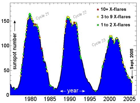
Above: Sunspot counts and X-flares during
the last three solar cycles. Note how solar activity continues
even during solar minimum. Credit: David Hathaway, NASA/NSSTC.
Hathaway offers a cautionary tale: Before 2005, the last solar
minimum was due in 1996 and the sun, at the time, seemed to be
behaving perfectly: From late-1992 until mid-1996, sunspots began
to disappear and there were precisely zero X-flares during those
long years. It was a time of quiet. Then, in 1996 when sunspot
counts finally reached their lowest value - bang! - an X-flare
erupted.
"The sun can be very unpredictable," says Hathaway,
which is something NASA planners must take into account when
they send humans back to the Moon and on to Mars.
Returning to 2005: is this year an aberration--or a normal rush
to the bottom of the solar cycle? "We need to observe more
solar cycles to answer that question," says Hathaway. "And
because each cycle lasts 11 years, observing takes time."
Meanwhile, Hathaway is waiting for 2006 when solar minimum finally
arrives. Who knows what the Sun will do then? |
KEY WEST, Fla. -- Hotel workers secured
pool chairs and umbrellas, tourists boarded buses out of town
and lines of vehicles snaked out of the lower Florida Keys
as Tropical Storm Rita churned toward the exposed island chain.
Rita, which strengthened Sunday into a tropical storm with
sustained winds of 50 mph, was forecast to be in the Straits
of Florida between the Keys and northern Cuba on Monday,
possibly as a Category 1 hurricane, forecasters said.
The entire Keys was under a hurricane warning. Rainfall totals
of 6 to 15 inches were possible in the Keys, with 3 to 5 inches
possible across southern Florida. Storm surges of 6 to 8 feet
above normal tide levels were predicted to batter the Keys.
Officials issued evacuation orders Sunday for visitors -
but not residents - from the Seven Mile Bridge near Marathon
to Key West, including the Dry Tortugas.
"We're happy to get out of here before the storm comes," said
Joan Taylor, 73, of Midland Park, N.J., who was planning to
fly out of Key West on Monday.
The stream of vehicles leaving the Keys on Sunday included
RVs, cars towing boats and thousands of motorcycle riders who
left an annual gathering a day early. U.S. 1, the lone highway
in the Keys, was packed.
Gov. Jeb Bush declared a state of emergency
for Florida, which gives the state authority to oversee evacuations
and activate the National Guard, among other powers.
Despite the evacuation order, however, some hotels and restaurants
in Key West remained open, and few businesses were boarded
up Sunday night.
In the Bahamas, which could be struck by Rita first, few
on Mayaguana Island bothered to board their windows or stock
up on emergency supplies as they normally would for a hurricane,
said Earnel Brown, manager of the Baycaner Beach Resort.
"I don't expect that much trouble," Brown said. "I
don't think we're going to have that much damage from it."
At 2 a.m. EDT, Rita was centered about 275 miles east-southeast
of Nassau, Bahamas, and about 545 miles east-southeast of Key
West. It was moving to the west-northwest near 10 mph, according
to the National Hurricane Center.
Long-range forecasts showed the system moving
into the Gulf of Mexico late in the week as a hurricane, then
possibly approaching Mexico or Texas.
But forecasters warned those across the U.S. southern coast
that long-term predictions are subject to large errors. That
means that areas ravaged by Katrina should be watching the
storm.
Rita is the 17th named storm of the Atlantic
hurricane season. That makes this season the fourth busiest
since record keeping began in 1851 - 21 tropical storms formed
in 1933, 19 developed in 1995 and 1887 and 18 formed in 1969,
according to the hurricane center.
Four hurricanes struck Florida last year, killing dozens
of people and causing $19 billion in insured losses in Florida.
Hurricane Dennis brushed by the Keys in July, flooding some
Key West streets, toppling trees and knocking out power, before
slamming the Florida Panhandle.
Florida was also hit this year by Hurricane Katrina. Eleven
people died there.
Farther out in the Atlantic, Hurricane Philippe
formed late Sunday well east of the Lesser Antilles. At 11
p.m., Philippe had maximum sustained winds near 75 mph, and
was centered about 390 miles east of the Leeward Islands and
was moving to the north-northwest near 8 mph.
The hurricane season started June 1 and ends Nov. 30. |
KEY WEST, Fla. - Thousands of residents
fled the Florida Keys as Tropical Storm Rita barreled toward
the island chain, poised to grow into a hurricane with a potential
9-foot storm surge and sparking fears
it could eventually ravage the hobbled Gulf Coast.
South Floridians kept a wary eye on Rita, which threatened
to arrive Tuesday and drop up to 15 inches of rain on some
parts of the low-lying Keys. Oil prices
surged on the possibility that oil and gas production would
be interrupted once again.
"I've lived in Florida all my life," said James
Swindell, 37, who shopped along a cleared-out Miami Beach on
Monday. "You always have to be worried about a storm,
because they are too unpredictable and they can shift on you
at the last minute. Nobody knows what they are going to do."
In New Orleans, the mayor suspended his plan
to start bringing residents back to the city after forecasters
warned that Rita could follow Hurricane Katrina's course into
the Gulf of Mexico and shatter his city's already weakened
levees.
The storm had top sustained winds of 70 mph early Tuesday,
and it was expected to strengthen into a Category 1 hurricane,
with winds of at least 74 mph, as it approached the Keys. The
storm's outer rain bands began drenching the Keys and Miami-Dade
County early Tuesday after felling trees in the Bahamas.
"The main concern now is the Florida Keys," said
Max Mayfield, director of the National Hurricane Center in
Miami. "It's moving over very warm water and that's extremely
favorable for development."
Hurricane warnings were posted for the Keys and Miami-Dade
County, the hurricane center said. Residents and visitors were
ordered to clear out of the Keys, and voluntary evacuation
orders were posted for some 134,000 Miami-Dade residents of
coastal areas such as Miami Beach.
"We're just trying to get enough gas to get home," said
Andres Sweeting, 29, of Miami, as he stopped at a Coconut Grove
gas station with his family. Long lines of customers had depleted
two of the station's four gasoline tanks. [...]
At 5 a.m. EDT, Rita was centered about 160 miles east-southeast
of Key West. It was moving west-northwest near 15 mph, according
to the hurricane center.
In the Bahamas, no serious damage was reported after Rita
passed to the south. However, fishermen had dragged their boats
to dry land and some people shuttered their windows - a sign
that normally laid-back islanders had been concerned about
the storm.
Officials in Galveston, Texas - nearly 900
miles from Key West - were already calling for a voluntary
evacuation. Forecasters said Rita could make landfall in Mexico
or Texas by the weekend, with a possibility that it could turn
toward Louisiana.
Louisiana Gov. Kathleen Blanco urged everyone in the southwest
part of the state to prepare to evacuate. "If Rita passes
us by, we will thank the Lord for our blessings," Blanco
told the state's storm-weary residents in a televised address.
[...]
Crude-oil futures rose above $67 a barrel
Monday, in part because of worries about Rita. About 56 percent
of the Gulf's oil production was already out of operation Monday
because of Katrina's damage, the federal Minerals Management
Service said.
Elsewhere in the Atlantic, Hurricane Philippe was far out
at sea and posed no immediate threat to land. The hurricane
season started June 1 and ends Nov. 30. |
This year, hurricanes just aren't acting
like they used to.
The major storms are bucking traditional
patterns by forming in the western, rather than eastern,
Atlantic Ocean. Instead of taunting worried residents for
days, they materialize, it seems, overnight.
The trend has baffled scientists and ratcheted
up panic levels for South Floridians.
"It's crazy," said Robin Wagner, 45, of Hollywood. "They
come so quick. With Katrina, before we knew it, it was on us."
Hurricane Katrina swept through Broward and Miami-Dade counties
last month as a Category 1 storm -- a scant two days after
developing in the Caribbean. Storms typically come to life
in the far eastern Atlantic Ocean, often near Cape Verde, then
pinwheel westward for several days, their ultimate course studied
with dread speculation by those in its path.
This year's nine hurricanes have formed west of 55 degrees
longitude, said meteorologist Jim Lushine of the National Weather
Service in Miami-Dade County. Rita, for example, was but a
soggy blob hardly worthy of notice on Saturday night. Sunday
morning, it was a threat.
A speedy arrival can bedevil nervous homeowners, but overall
it's a good thing.
"By forming farther west, they don't have quite the potential
for strength as if they came all the way across" the ocean,
Lushine said. "It hasn't had enough time to build up."
Hurricanes feed on warm water, but West Atlantic storms don't
stick around long enough to be energized by the Caribbean's
tepid currents. Like Katrina -- and
Rita's expected track -- they can brush by or through Florida
as weaklings, then spin into the Gulf of Mexico and bulk up
into highly destructive Category 4 or 5 storms.
Why this season's storms are appearing so far west is a matter
of speculation for forecasters.
Chris Landsea, a meteorologist with the National Hurricane
Center in Miami-Dade, said, "It's not something we predicted,
and I'm not sure it's something we can anticipate way in advance."
One comparable year was 1969, Landsea said, when 10 of 12
hurricanes formed west of 55 degrees longitude.
The ingredients needed for a hurricane -- warm water, an unstable
atmosphere and lack of wind shear -- have been present in the
western, not eastern, Atlantic this year. "Why
further west? We don't know," Landsea said. [...]
Still, the appearance of an "instant hurricane" can
unnerve homeowners used to having days to prepare.
"It makes people frantic," said Holly Markert, 28,
a county employee from Fort Lauderdale. "We need more
notice than this."
Besides compressing prep time, pop-up storms mean supplies
come up short because stores don't have time to re-stock. More
residents in the target zone lack the goods they need to endure
floods or power outages.
"All of a sudden, all you've got is
a day to prepare," complained Del Dacks, 37, of Fort Lauderdale.
Broward emergency manager Tony Carper said: "Anytime you
have less time to react and operationally to respond, it's
a problem."
Not for Doreen Gargano, 61, who has a home in Fort Lauderdale
and a boat in Islamorada.
"Once it's coming, you're moving quickly, you don't have
time to think about it," she said. "When you watch
it for days and days, I think it's really more nerve-racking." |
KEY WEST, Fla. - Residents of the Florida
Keys exhaled after Hurricane Rita largely spared the island
chain, while those in Texas and already-battered Louisiana
fretted the strengthening storm could become a Katrina-esque
monster and target them by week's end.
Rita was upgraded to a Category 3 storm early Wednesday
with 115 mph winds and forecasters said it could further
intensify, sparking an order for mandatory evacuations in
New Orleans and Galveston, Texas.
Federal officials told Gulf Coast residents to begin bracing
for a blockbuster storm. "Up and down the coastline, people
are now preparing for what is anticipated to be another significant
storm," President Bush said.
Acting FEMA Director R. David Paulison told
reporters that the agency has aircraft and buses available
to evacuate residents of areas the hurricane might hit. Rescue
teams and truckloads of ice, water and prepared meals were
being sent to Texas and Florida.
"I strongly urge Gulf coast residents to pay attention" to
the storm, he said.
Stung by criticism of the government's slow initial response
to Hurricane Katrina, President Bush signed an emergency declaration
for Florida and spoke with Texas Gov. Rick Perry about planning
for the storm's landfall.
Rita created relatively few problems along the Keys, where
thousands of relieved residents who evacuated are expected
to begin returning in earnest on Wednesday.
During daytime hours, several stretches of the Keys highway,
U.S. 1, were barricaded because of water and debris; by nightfall,
only one small problem area remained and the entire highway
was passable, the Florida Highway Patrol said.
There were reports of localized flooding, and some sections
of the Lower Keys were still without power early Wednesday.
But the storm's raging eye did not hit land.
"It was fairly nothing," said Gary Wood, who owns
a bar in Marathon, about 45 miles northeast of Key West. "It
came through and had a good stiff wind, but that was about
it."
In Key Colony Beach, an oceanfront island off Marathon, Mayor
Clyde Burnett said a restaurant and hotel were damaged by water
and wind, but that widespread problems simply didn't arrive
as expected.
Visitors ordered out of the Keys will be invited back Friday,
and virtually all other voluntary evacuation orders in South
Florida were lifted after Rita roared past.
Now, all eyes following Rita are turning toward the Gulf -
where the hurricane is causing new anxiety among Katrina victims
in Mississippi, Louisiana and Alabama.
At 2 a.m. EDT, Rita's eye was about 145 miles west of Key
West. The storm was moving west at 14 mph - a track that kept
the most destructive winds at sea and away from Key West.
"There's still plenty of warm water
that it needs to move over in the next couple days. The forecast
is favorable for further intensification," said Michelle
Mainelli, a meteorologist at the National Hurricane Center.
Those were words that Gulf coast residents certainly did not
want to hear. Even those who had survived major hurricanes
were getting ready to leave, not wanting to challenge Rita's
potential wrath or cling to hope that they'd be spared in the
same manner the Keys were.
"Destination unknown," said Catherine Womack, 71,
who was boarding up the windows on her one-story brick house
in Galveston. "I've never left before. I think because
of Katrina, there is a lot of anxiety and concern. It's better
to be safe than sorry."
About 80 buses were set to leave the city Wednesday bound
for shelters 100 miles north in Huntsville. The buses were
part of a mandatory evacuation ordered by officials in Galveston
County, which has a population of nearly 267,000. [...] |
Before the 2005 hurricane season is done,
you might read about Hurricane Alpha.
Each year, 21 common names are reserved for Atlantic Basin
hurricanes, with the list arranged alphabetically and skipping
certain letters. Rita is the 17th named storm in the Atlantic
Basin this year. There are only four left.
So what will officials do after tropical storm Wilma develops,
assuming it does?
"We go to the Greek alphabet," said Frank Lepore,
spokesman for the National Hurricane Center.
This gives the World Meteorological Organization (WMO), the
United Nations agency responsible for choosing hurricane names,
24 more names to work with, from Alpha to Omega, and including
such names as Omicron and Upsilon.
Could happen
This season started out as the busiest ever,
with 4 named storms by July 5. It never really let up.
"The August update to Atlantic hurricane season outlook
called for 18 to 21, so I would hope it doesn't go any higher
than that, but it's a possibility," Lepore said. [...]
The twenty-one names reserved each year (the letters q, u,
x, y and z are not used) are recycled every six years, minus
those retired (such as Hugo and Andrew and, you can bet, Katrina).
When a name is retired, the WMO chooses a new name to replace
it.
The year with the most documented tropical storms was 1933,
when there were 21 in the Atlantic Basin, but this was before
hurricanes were routinely named. Activity is known to wax and
wane in cycles that last decades. But
some studies have suggested that global warming may be causing
increases in hurricane intensity and frequency. Many
scientists are skeptical.
Hurricane season runs from June 1 to Nov. 30. |
WASHINGTON - Hurricane Rita could have
a "substantial impact" on U.S. Gulf Coast refineries,
a situation that the nation's already tight gasoline market
cannot afford, the head of the U.S. Energy Information Administration
said on Wednesday.
Hurricane Rita was packing 150 mph winds as it churned through
the Gulf of Mexico, with computer models forecasting landfall
south of Houston on Saturday.
"There's a risk that we could
have a substantial impact on further refineries," EIA
Administrator Guy Caruso told a Senate Commerce Committee
hearing on gasoline prices. "We
clearly cannot afford any further disruptions in gasoline
production and capacity."
Caruso's remarks echoed worries expressed by oil market traders.
Four large refineries in the Gulf Coast region, which together
account for about 5 percent of U.S. capacity, remain out of
service from Hurricane Katrina last month.
Soon after Katrina hit Louisiana and Mississippi on August
29, the nationwide average retail gasoline price jumped to
$3.07 per gallon, nearly tying the inflation-adjusted high
of $3.12 set in 1981.
Earlier on Wednesday, the EIA said Rita
could threaten up to 18 Texas oil refineries that have a
combined capacity of 4 million barrels per day, or nearly
one-fourth of the nation's total refining capacity.
"While not all of this capacity would be affected under
any scenario, it does point out how much refining capacity
is at risk," the EIA said in a weekly oil market report.
Texas has 26 refineries, with 18 located
near the Gulf of Mexico coastline, it said.
Marathon Oil, Valero Energy Corp. and BP Plc were among refiners
that shut down or reduced operating rates at Texas refineries
to prepare for Rita.
Thousands of workers were also evacuated from offshore drilling
rigs and production platforms as a safety precaution.
"People were worried post-Katrina, as
we have real tight product supply," said Jamal Qureshi,
analyst at PFC Energy. "Now we have a hurricane heading
for the bigger part of the coastal refinery center, threatening
to blow a huge hole in products supply."
Valero, the nation's biggest refiner, said
Rita's impact could be a "national disaster" and
unleash retail gasoline prices above $3 a gallon.
Wholesale gasoline futures on the New York Mercantile Exchange
settled at $2.0531 a gallon on Wednesday, up 7.65 cents. The
futures price hit a record $2.92 a gallon soon after Katrina
hit. |
SAN ANTONIO (Reuters) - Valero Energy
Corp. Chairman and Chief Executive Bill Greehey said Hurricane
Rita's impact on U.S. crude oil production and refining could
be a "national disaster."
"If it hits the refineries, and we're short refining
capacity, you're going to see gasoline prices well over $3.00
a gallon at the pump," Greehey said in a Tuesday night
interview.
Valero became the largest U.S. refiner earlier this year when
it completed the purchase of Premcor Inc. Valero operates refineries
in Port Arthur, Houston, Texas City and Corpus Christi, Texas
-- all potentially in the path of Hurricane Rita.
"It's going to be coming across the (U.S.) Gulf (of Mexico)," Greehey
said. "There's a lot of oil platforms, oil rigs, (natural)
gas platforms, gas rigs. It could have a significant impact
on supply and prices, and then, depending on what it does to
the refineries, there are still four refineries that are shut
down. So this really is a national disaster."
Refineries in Houston and Texas City process 2.3 million barrels
of crude oil or 13.5 percent of daily U.S. refining capacity.
The Beaumont-Port Arthur, Texas, refineries account for another
1.1 million barrels in refining capacity.
Based on Rita's current forecast path Texas City, Houston,
Port Arthur and Beaumont could be lashed by high winds and
heavy rains from Rita's northeast quadrant, which often packs
the highest winds in a hurricane.
Valero announced on Wednesday morning it would reduce production
at its Houston and Texas City refineries to prepare for the
hurricane.
"You've got refineries that will start shutting down
in anticipation of the hurricane, and then if any of them have
permanent damage, we're going to be
dependent on imports. Following Katrina, this is really
serious." |
Rita
could equal $5 gas
The timing and strength of the latest storm could cause worse
spike at the pumps than Katrina did. |
By Chris Isidore
CNN/Money
September 21, 2005: 5:46 PM EDT |
NEW YORK - Remember when gas spiked to
$3-plus a gallon after Hurricane Katrina? By this time next
week, that could seem like the good old days.
Weather and energy experts say that as bad as Hurricane
Katrina hit the nation's supply of gasoline, Hurricane Rita
could be worse.
Katrina damage was focused on offshore oil platforms and
ports. Now the greater risk is to oil-refinery capacity,
especially if Rita slams into Houston, Galveston and Port
Arthur, Texas.
"We could be looking at gasoline lines and $4 gas,
maybe even $5 gas, if this thing does the worst it could
do," said energy analyst Peter Beutel of Cameron Hanover. "This
storm is in the wrong place. And it's absolutely at the wrong
time," said Beutel.
Michael Schlacter, chief meteorologist at Weather 2000,
said Rita now appears most likely to hit between Port Arthur
and Corpus Christi, Texas, sometime between Friday afternoon
and Saturday morning.
Just about all of Texas's refinery
capacity lies in that at-risk zone. (For a look
at CNN.com's coverage of Hurricane Rita, click
here.)
"There is no lucky 7-10 split scenario to use a bowling
analogy," he said. "If you're [a refiner] within
200 miles, you're going to feel the effect."
Compounding Katrina's impact
When Katrina hit, 15 refineries, nearly all in Louisiana
and Mississippi, with a combined capacity of about 3.3 million
barrels a day were shut down or damaged, according to the
Energy Department. That represented almost 20 percent of
U.S. refining capacity.
Within a week, almost two-thirds of that damaged capacity
had resumed some operations, according to the department.
But four refineries with nearly 900,000 barrels a day of
capacity are still basically shut down.
If Rita hits both the Houston-Galveston area, as well as
the Port Arthur-Beaumont region near the Texas-Louisiana
border, that could take out more than 3 million barrels of
capacity a day, according to Bob Tippee, editor of the industry
trade journal Oil & Gas Journal in Houston.
"Before Katrina, the system was already so tight that
the worst-case scenario was for a disruption that took 250,000
barrels of capacity out of the picture. That would have been
considered a major jolt," said Tippee.
"We're already in uncharted territory now. We can't
project what happens from another shot the size of Katrina
or worse."
Part of the problem is that skilled crews
needed to make refinery repairs are already busy trying to
fix the Katrina damage. That would extend recovery time from
Rita.
"[Rita] could have a significant impact on supply
and prices -- this really is a national disaster," Valero
Energy CEO Bill Greehey in an interview with Reuters Tuesday
evening.
Gas not the only concern
Problems could spread beyond the gas pumps.
Tippee said that natural-gas prices could see a further
spike, since so many of the offshore platforms off of Texas
produce natural gas, not crude oil.
And while gasoline imports have helped
bring gas prices down from record highs, there isn't as much
potential for heating-oil imports, he noted.
"Gasoline tends to obscure everything, especially since
we aren't paying heating bills right now," said Tippee. "But
we were already looking at a winter fuel problem. We're about
to take another hit that will cause a lot of problems."
Schlacter said even the oil platforms off the Louisiana
Gulf Coast, which are not likely to take a direct hit from
Rita, could be affected by large waves churning up the Gulf
of Mexico as the storm passes to the south. Waves of as much
as 40 to 50 feet could hit the platforms off the Texas Coast,
he estimated.
Tippee said that production across the Gulf is already
being affected by oil companies pulling
workers off platforms ahead of the storm. And it's not
just domestic oil being interrupted.
The Louisiana Offshore Oil Port (LOOP),
the nation's largest gateway for overseas oil, stopped accepting
deliveries of its 1.2 million barrels of oil a day Wednesday
afternoon due to high seas, LOOP spokeswoman Barb Hesterman
told Reuters. She said the disruption was expected to be "for
a short time."
But if Katrina is any guide, it could take several days
after Rita passes for production to resume even at oil and
gas platforms that escape damage. [...] |
Oil
dips as Rita shifts path
Prices fall amid signs storm may avoid Houston refining hub;
30% of Gulf refining capacity off-line. |
CNN
September 23, 2005: 6:18 AM EDT |
|
SYDNEY (Reuters) - Oil fell below $66 a barrel and gasoline prices
slid Friday as Hurricane Rita lost some intensity, while its
direction may avert a direct hit on the heart of the Texas refining
hub near Houston.
But with almost 30 percent of U.S. refining capacity shut
down across the Gulf Coast and gasoline inventories already
running low, many dealers took a cautious approach, waiting
to see whether Rita wreaks as much havoc as last month's Katrina.
U.S. light crude was down 86 cents to $65.64 a barrel, extending
overnight losses of 30 cents. London Brent crude fell 89 cents
to $63.71 a barrel.
The storm, still a Category 4 and equivalent in ferocity
to Hurricane Katrina, is expected
to hit by Saturday the upper Texas and southwest Louisiana
coast, just to the east of main production and population centers
in Galveston, Houston and Corpus Christi.
Estimated windspeeds have eased to 140 miles per hour from
175 mph over the past day.
"The market is now taking a pause to assess just what
Rita will do," said Jarrod Kerr, economist at JP Morgan
in Sydney. "It won't fully digest Rita until Monday, although
the forecasts are looking a little better than yesterday at
present.
"There's plenty of oil out there drums-wise,
the problem remains converting that into product, with more
damage no doubt translating into a negative for the global
consumer," he added.
Gasoline futures which surged Thursday, led the early retreat,
falling 6.93 cents to $2.0701 a gallon. Heating oil was off
4.72cents to $1.9986 a gallon.
Oil traders said the upside for prices was limited by the
possibility that members of the International Energy Agency
(IEA) could extend their post-Katrina emergency oil reserve
release, which includes refined fuels such as gasoline and
diesel.
The Department of Energy is ready
to loan oil from its Strategic Petroleum Reserve (SPR)
as it did after Katrina, but it has little resource to deal
with a shortfall in refined products.
"If there is a supply disruption, which there is a good
chance there will be, they may not hesitate to release the
SPR and we already have crude oil and products coming from
Europe after Katrina," said John Brady, broker at ABN
Amro in New York.
Production halt
In addition to four refineries still out of action after
Katrina, 13 Texan and two Louisiana plants have been closed
as a precaution against Rita. Four others have reduced
operations.
Exxon Mobil Corp. announced the closure of the country's
largest refinery at Baytown, Texas and its Beaumont facility,
the two disabling more than 900,000 barrels per day (bpd) alone.
Rita's onslaught has brought to a halt recovery efforts after
Katrina churned through the Gulf of Mexico in late August,
damaging oil and gas platforms, flooding the Louisiana refining
center and sending crude prices to a record $70.85 a barrel.
Almost 92 percent of offshore oil output,
or 1.379 million bpd, is out of action in the Gulf of Mexico,
the U.S. Minerals Management Service said. Almost 66 percent
of gas output, or 6.594 billion cubic feet is also down.
But with U.S. crude supplies almost 12 percent above last
year's levels, most concern is focused on sky-high gasoline
prices and heating oil as the U.S. winter approaches.
Analysts warned that any damage to natural gas facilities
could boost prices because reduced supplies would be far more
difficult to replace than lost crude and could spur additional
demand for heating oil and utility fuel oil.
The threat of further supply outages also
hung over Nigeria, where more than 100 armed militants stormed
an oil platform on Thursday, shutting down only a small volume
of output but raising the specter of further disruptions from
local groups. |
The number of severe hurricanes has doubled
worldwide even though the total number of hurricanes has dropped
over the last 35 years, a new study finds.
The increase in major storms like Katrina coincides
with a global increase of sea surface temperatures, which
scientists say is an effect of global warming.
The possible relationship between global warming and hurricane
strength has been a topic of controversy for years.
The new study supports another one released in July, in which
climatologist Kerry Emanuel of the Massachusetts Institute
of Technology showed
for the first time that major storms in both the Atlantic
and the Pacific since the 1970s have increased in duration
and intensity by about 50 percent.
The new reearch finds that total number of hurricanes worldwide – except
for in the North Atlantic – decreased during during the
period from 1970 to 2004 compared to years prior.
Yet in the same period, the global number of intense Category
4 and 5 hurricanes has nearly doubled in number, jumping
from 50 per five years during the 1970's to 90 per five years
in the last decade.
This increase is most evident in the North Atlantic basin,
where from 1975 to 1989 there were 16 such hurricanes, but
from 1990-2004 there were 25, a 56 percent increase.
Warmer seas
Using satellite data, the scientists
link the increase in major storms to rising sea surface temperatures,
which they believe have been influenced by global warming. [...] |
Hurricanes
can trigger swarms of weak earthquakes and even set the Earth
vibrating, according to the first study of such effects.
When Hurricane Charley slammed into Florida
in August 2004, physicist Randall Peters of Mercer University
in Macon, Georgia, had a seismometer ready to monitor any
vibrations in the Earth's crust. He did so for over 36 hours
as Charley travelled briefly over Florida, then slid back
out into the Atlantic.
As the hurricane reached land, the seismometer
recorded a series of "micro-tremors" from the Earth's
crust. This happened again as the storm moved back out to sea.
Then, as Charley grazed the continental shelf on its way out,
it caused a sharp seismic spike. "I suspect the storm
triggered a subterranean landslide," says Peters.
More surprisingly, the
storm also caused the Earth to vibrate. The planet's
surface in the vicinity of the hurricane started moving up
and down at several frequencies ranging from 0.9 to 3 millihertz. Such
low-frequency vibrations have been detected following large
earthquakes, but this is the
first time a storm has been found to be the cause. |
|
HOUSTON, Texas (AP) -- Wilma Skinner would like to scream
at the officials of this city. If only they would pick up
their phones.
"I done called for a shelter, I done called for help.
There ain't none. No one answers," she said, standing
in blistering heat outside a check-cashing store that had just
run out of its main commodity. "Everyone
just says, 'Get out, get out.' I've got no way of getting out.
And now I've got no money."
With Hurricane Rita breathing down Houston's neck, those with
cars were stuck in gridlock trying to get out. Those like Skinner
-- poor, and with a broken-down car -- were simply stuck and
fuming at being abandoned, they say.
"All the banks are closed, and I just got off work," said
Thomas Visor, holding his sweaty paycheck as he, too, tried
to get inside the store, where more than 100 people, all
of them black or Hispanic, fretted in line. "This
is crazy. How are you supposed to evacuate a hurricane if you
don't have money? Answer me that?"
Some of those who did have money, and did try to get out,
didn't get very far.
Judie Anderson of La Porte, Texas, covered just 45 miles in
12 hours. She had been on the road since 10 p.m. Wednesday,
headed toward Oklahoma, which by Thursday was still very far
away.
"This is the worst planning I've
ever seen," she said. "They say, 'We've learned
a lot from Hurricane Katrina.' Well, you couldn't prove it
by me." [...] |
HOUSTON, Texas -- A bus caught fire and
exploded early Friday on a crowded Texas interstate, killing
as many as 24 people who were fleeing ahead of Hurricane Rita.
The bus, carrying about 45 elderly evacuees, burst into
flames on Interstate 45 south of Dallas. It pulled over and
people were getting off when a series of explosions ripped
through the bus.
Dallas County Sheriff's Sgt. Don Peritz said 14 or 15 people
got off the bus and said as many as 24 people may have died.
Peritz said the fire was believed to have started in the bus's
brake system and may have caused oxygen canisters on the bus
to explode.
Authorities blocked all lanes of the
interstate, complicating the already grueling exodus from
the Texas coast. [...] |
MANILA - Typhoon Damrey swept away from
the northern Philippines on Friday after killing at least 16
people across the main island of Luzon, the Office of Civil
Defense (OCD) said.
Damage to property and agriculture appeared to be low after
the typhoon hit the east coast of Luzon on Tuesday but most
areas in the northern provinces of Ilocos Norte, Cagayan
and Isabela were under knee-deep water, said Anthony Golez,
an OCD spokesman.
"Most of the casualties were drowning victims," he
said, adding about 20,000 people were still in temporary shelters
in the northern provinces.
Damrey had moved into the South China Sea and was heading
toward southern China and Hong Kong with wind speeds up to
120 kph (75 mph).
"All public storm warning signals are now lowered but
occasional rains with moderate to strong winds may still be
expected over western Luzon," Golez said, citing a report
from the weather bureau.
Local agriculture officials had reported very minimal impact
to rice and corn farms, he said, estimating crop damage would
reach about 60 million pesos.
Soldiers and civilian engineers had started repairing roads,
bridges and power lines in the affected areas.
Typhoons and tropical storms regularly hit the Philippines,
an archipelago of some 7,000 islands. In the worst disaster
in recent years, more than 5,000 people died in floods triggered
by a typhoon in southern Leyte island in 1991.
Last year, a series of storms left about 1,800 people dead
or missing, including 480 who were killed when heavy rains
triggered mudslides that buried three towns in Quezon, an eastern
province on Luzon. |
| HYDERABAD,
India (AP) -- Heavy downpours sent rivers over their embankments,
killing at least 56 people and forcing the evacuation of thousands
in southern India, officials said Wednesday.
Helicopters plucked people from danger in the worst hit areas
of Andhra Pradesh state and delivered thousands of tons of
food, medicine and blankets to camps for the displaced. Boats
rescued hundreds of others.
The rains flooded railroad tracks and major highways along
the coast, marooning hundreds of trucks, buses and cars, said
disaster relief official Shashank Goel in Hyderabad, capital
of Andhra Pradesh.
Relief workers evacuated more than 140,000 residents of low-lying
villages to 465 relief camps set up in government buildings
and schools located on higher ground, Goel said.
Officials said at least 50 people were killed by rain and
strong winds, which flattened homes, knocked down power lines
and uprooted trees. Six people were killed when their homes
in coastal districts collapsed.
The Godavari and Krishna rivers breached their banks at several
places, flooding farms. Floods demolished more than 77,000
homes and damaged another 7,800 homes, Goel said.
The surging waters washed away or damaged 254,000 acres of
tobacco, rice and vegetable fields, said Y.S. Rajasekhar Reddy,
the state's top elected official.
In Bangladesh, a tropical depression churned through the Bay
of Bengal and pushed walls of water onto the country's coast,
forcing thousands to flee.
At least 16 fishermen were killed when three boats capsized,
the Janakantha newspaper said, quoting fishermen who returned
to shore.
Anxious relatives of fishermen gathered at beaches waiting
for loved ones, local reporters said. ATN Bangla TV said that
200 fishing boats were missing. |
A state of emergency has been declared
in Brazil's western state of Acre as fires continue to rage
across the country's vast Amazon region.
Thousands of hectares of the world's largest rainforest
have already been destroyed by the blazes.
Acre's Governor Jorge Viana urged the federal government
in Brasilia to act swiftly, expressing particular concerns
about pollution caused by the smoke.
Hundreds of soldiers, rescuers and also local residents are
battling the fires.
Correspondents say it is not known what
caused the blazes, some of which broke out nearly two weeks
ago.
Some 500 people have been evacuated from the area, officials
said earlier this week.
In the past, authorities have blamed farmers who burned forested
areas in the dry season to make space for their crops.
The blazes have often raged out of control in recent years.
|
SAN ANTONIO, Texas (AP) -- Military officials
told President Bush on Sunday that the U.S. needs a national
plan to coordinate search and rescue efforts following natural
disasters or terrorist attacks.
Bush said he is interested in whether the Defense Department
should take charge in massive national disasters.
"Clearly, in the case of a terrorist attack, that would
be the case, but is there a natural disaster -- of a certain
size -- that would then enable the Defense Department to become
the lead agency in coordinating and leading the response effort?" Bush
asked. "That's going to be a very important consideration
for Congress to think about." [...]
Under the existing relationship, a state's governor is chiefly
responsible for disaster preparedness and response. Governors
can request assistance from the Federal Emergency Management
Agency. If federal armed forces are brought in to help, they
do so in support of FEMA, through Northern Command, set up
as part of a military reorganization after the attacks of September
11, 2001. [...]
Bush got an update about the federal hurricane response from
military leaders at Randolph Air Force Base. He heard from
Lt. Gen. Robert Clark, joint military task force commander
for Hurricane Rita, and Maj. Gen. John White, a task force
member, who described search and rescue operations after Hurricane
Katrina as a "train wreck."
With Katrina, "we knew the coordination piece was a problem," White
said. He said better coordination is needed to prevent five
helicopters, for example, from showing up to rescue the same
individual. "With Rita, we had
the benefit of time. We may not have that time in an earthquake
scenario or similar incident," White said.
"With a national plan, we'll have a quick jump-start
and an opportunity to save more people," White said.
Speaking of the helicopter example, White said, "That's
the sort of simplistic thing we'd like to avoid." He added, "We're
not maximizing the use of forces to the best efficiency. Certainly
that was a train wreck that we saw in New Orleans."
Bush thanked White for his recommendations.
"This is precisely the kind of information I'll take
back to Washington to help all of us understand how to do a
better job," the president said.
Later, Bush spent a little more than an hour getting a private
briefing in a FEMA joint field operations office that was set
up in an empty department store building.
He urged people not to be too eager to return to their homes.
"It's important that there be an orderly process," Bush
said. "It's important that there be an assessment of infrastructure."
Bush's comments came as residents along the Texas and Louisiana
coasts began clearing up debris and power crews worked to restore
power to more than 1 million customers in four states.
Rita, which hit the Gulf Coast early Saturday,
toppled trees, sparked fires and swamped Louisiana shoreline
towns with a 15-foot storm surge that required daring boat
and helicopter rescues of hundreds of people.
Still, the devastation was less severe than
that caused by Hurricane Katrina when it made landfall August
29, three days after striking Florida.
After the briefing, Bush attended a worship service at a chapel
on the base.
Bush's appearance was clearly a surprise to the base congregation.
The chaplain, Col. David Schroeder, said, "We usually
make new people stand up and introduce themselves." Everyone
laughed at that, and then he announced the president. Bush
stood along with the entire, clapping congregation.
Before returning to Washington, Bush was visiting Baton Rogue,
Louisiana. The White House has not released details of his
scheduled.
On Saturday, he made a stop in Austin, Texas, and at the U.S.
Northern Command in Colorado. [...] |
CAMERON, Louisiana -- Towns near where
Hurricane Rita made landfall have had all but a handful of
buildings destroyed, including nearly all homes in Cameron,
Holly Beach and Creole, officials say.
Though less destructive than Hurricane
Katrina, Rita caused extensive damage when it roared ashore
Saturday morning near the Texas-Louisiana border with 120
mph winds.
Along the state line, Louisiana's Cameron Parish was under
as much as 15 feet of water, and thousands of homes were destroyed,
said Freddie Richard, the head of emergency preparedness for
the parish of 10,000 residents.
About 45 miles south of nearby Lake Charles, every home was
destroyed in the town of Holly Beach, Richard told CNN.
In the parish seat of Cameron, 90 percent of homes were destroyed,
he said.
In Creole, 70 percent of residences were destroyed, with little
more than the courthouse and an elementary school still standing,
according to Richard. (City-by-city
impact)
More than 925,000 customers in Texas, Louisiana, and Mississippi
are without electricity as a result of Hurricanes Rita and
Katrina, officials said.
Coast Guard Vice Adm. Thad Allen told CNN that no deaths had
been reported in Louisiana, and Texas Gov. Rick Perry reported
no storm-related deaths in his state.
But a Rita-spawned tornado killed one person in Mississippi,
and 24 people died Friday when a bus carrying evacuated nursing
home residents caught fire and was ripped by explosions on
Interstate 45 south of Dallas.
Water in Lake Charles was receding Sunday,
revealing buildings smashed to bits.
"The lake has risen higher than
I've ever seen in my lifetime," said Lake Charles Mayor
Randy Roach. But, he added, "Everyone who wanted
to got out."
Lake Charles Police Chief Donald Dixon said "sporadic" looting
had taken place and will likely increase as food and water
run out.
The city has no power, no sewer system, no open stores or
gasoline stations, he said, while downed trees and power lines
make the city "very unsafe."
But he vowed to protect the property of people who evacuated.
About 15 people were arrested for looting, including some at
an adult video store.
Lake Charles and surrounding Calcasieu Parish, on the Texas-Louisiana
state line, were closed Sunday to returning residents because
of damage to roads and infrastructure.
City and parish officials have set a target date of October
3 -- next Monday -- for allowing residents to return. They
want to have them return in stages, with business owners being
allowed back earlier.
Farther west, in Port Arthur and Sabine Pass,
Texas, officials were conducting house-to-house searches for
victims or survivors, Port Arthur Mayor Oscar Ortiz said.
Ortiz was among many locals whose homes were destroyed. "It's
all gone," he told CNN.
He said two refineries appeared to be leaking
gasoline. Boats and ships were tossed onto roadways by Rita's
storm surge, and oil rigs ripped loose from their moorings
had drifted ashore, he said.
"We've got a lot of damage," he said. [...] |
POCATELLO - To the rest of the country,
Scott Stevens is the Idaho weatherman who blames the Japanese
Mafia for Hurricane Katrina. To folks in Pocatello, he's the
face of the weather at KPVI News Channel 6.
The Pocatello native made his final Channel 6 forecast Thursday
night, leaving a job he's held for nine years in order to
pursue his weather theories on a full-time basis.
"I'm going to miss that broadcast, but I'm not going
to miss not getting home until 11 p.m.," Stevens said. "I
just don't have the hours of the day to take care of my research
and getting those (broadcasts) out and devoting the necessary
research to the station."
It was Stevens' decision to leave the TV station, said KPVI
general manager Bill Fouch.
"When Scott signed his current contract, he told Brenda
and me at the time that it would be his last contract," Fouch
said Thursday. "We knew, but the timetable moved up because
of all the attention (he's been getting.)"
Since Katrina, Stevens has been in newspapers across the country
where he was quoted in an Associated Press story as saying
the Yakuza Mafia used a Russian-made electromagnetic generator
to cause Hurricane Katrina in a bid to avenge the atomic bomb
attack on Hiroshima. He was a guest on Coast to Coast, a late
night radio show that conducts call-in discussions on everything
from bizarre weather patterns to alien abductions. On Wednesday,
Stevens was interviewed by Fox News firebrand Bill O'Reilly.
Stevens said he received 30 requests to do radio interviews
on Thursday alone.
Fouch said Stevens wanted to leave as quickly as possible
because his "plate is full," and he needs to take
advantage of the opportunities that exist now.
Stevens said he's received offers that he's not at liberty
to discuss.
Stevens, 39, who was born in Twin Falls, plans to remain in
Pocatello, where his family remains. He said his family wishes
him the best in his future endeavors.
It costs him hundreds of dollars each month to run his Web
site, weatherwars.info, but he said that's a price he's willing
to pay.
"There's a chess game going on in the sky," Stevens
said. "It affects each and every one of us. It is the
one common thread that binds us all together."
Although the theories espoused by Stevens - scalar weapons,
global dimming - are definitely on the scientific fringe today,
there are thousands of Web sites that mention such phenomena.
"The Soviets boasted of their geoengineering capabilities;
these impressive accomplishments must be taken at face value
simply because we are observing weather events that simply
have never occurred before, never!" Stevens wrote on his
Web site. "The evidence of these weapons at work found
within the clouds overhead is simply unmistakable. These patterns
and odd geometric shapes seen in our skies, each and every
day, are clear and present evidence that our weather has been
stolen from us, only to be used by those whose designs for
humanity are rarely in alignment with that of the common man."
However, Stevens never discussed his weather theories on the
air during his time at Channel 6 - an agreement he had with
the station management. What the meteorologist chose to do
in his off time was his business, said his manager of eight
years.
Fouch said he would miss Stevens, whom he described as energetic,
easy-going and enthusiastic about the weather, but he is supportive
of his decision to pursue his passion.
"His theories are his theories," Fouch said. "But,
if you think about it - of all the TV weather people, he continues
to be the most accurate. It isn't his theories getting involved
with his professional job."
For Stevens, however, the recent attention to his theories
has been somewhat of a distraction from work.
"When there has been so much attention, it gets in the
way of them doing their jobs and me doing my job," Stevens
said.
Find out more:
To learn more about Stevens and his thoughts on manipulated
weather, check out his Web site at www.weatherwars.info, or
go to www.journalnet.com/articles/2005/03/06/opinion/opinion04.txt
to read the story that Journal City Editor Greg McReynolds
wrote about Stevens in March. |
Perched among the highlands of western
Cameroon, bordered by green mountains and cliff faces, Lake
Nyos is a scene of breathtaking beauty. But the picture is
deceptive. A detailed study reveals that without emergency
measures, the lake could release a lethal cloud of carbon dioxide,
capable of wiping out entire communities around its shores.
The warning, from a team of scientists, comes nearly 20
years after the lake belched an estimated 80m cubic metres
of CO2 into the atmosphere. Heavier than air, the cloud of
gas rolled down surrounding hillsides, engulfing villages.
Silent, odourless and invisible, it starved the air of oxygen,
asphyxiating hundreds of cattle and claiming the lives of
more than 1,700 people up to 26km away.
Article continues "It was one of the most baffling disasters
scientists have ever investigated. Lakes just don't rise up
and wipe out thousands of people," said George Kling,
an ecologist at the University of Michigan.
Researchers called in after the 1986 tragedy discovered that
the lake, which sits atop a volcano, contained record levels
of carbon dioxide. Gas bubbling up from the Earth's magma was
under such pressure at the bottom of the 200-metres-deep lake
that it dissolved until it reached saturation point. A slight
disturbance then released the dissolved gas as a devastating
bubble.
To prevent a recurrence, in 2001 engineers installed a pipe
to suck CO2 from the bottom of the lake and release it harmlessly
into the air. A similar pipe was also installed at nearby Lake
Monoun, where an eruption of CO2 killed 37 people in 1984.
But according to Dr Kling, too little has been done to make
the lakes safe. With colleagues at the US Geological Survey
and the Institute for Geological and Mining Research in Cameroon,
he spent 12 years testing the CO2 levels of both lakes. In
today's Proceedings of the National Academy of Sciences, they
report that without emergency intervention, the lakes are set
for further potentially devastating explosions. "In both
lakes, there's been a 12% to 14% reduction in overall gas content,
which is the good news," said Dr Kling. "The bad
news is that the single pipes are not sufficient to rapidly
remove as much as is needed to make them safe. There is still
more gas in both lakes than was released in the 1980s. We could
have a gas burst tomorrow that could be bigger than either
of those disasters and every day we wait is just an accumulation
of the probability that something bad is going to happen."
Dr Kling's team recommends the urgent installation of a further
four pipes in each lake at a rate of one a year. "By 2010,
those five pipes would be enough to get the carbon dioxide
down to safe levels," he said.
The danger around Lake Nyos has increased in recent years
as families evacuated for a generation since the 1986 eruption
have started to move back, encouraged by the fertile farmland.
The communities around Lake Monoun have expanded, meaning an
eruption there could kill more than in the 1980s. |
HANOI - Typhoon Damrey smashed into Vietnam
on Tuesday, tearing into vital networks of sea dykes on a long
stretch of coastline after more than 320,000 residents had
been evacuated.
Prime Minister Phan Van Khai had ordered that only young
people, police and soldiers stay behind to watch over dykes
built to keep the sea out of rice fields, but the barriers
were soon breached in some areas.
"The waves are high, rising across the dyke now," Agriculture
Minister Cao Duc Phat told state-run Vietnam Television from
the northern province of Nam Dinh as the typhoon whipped up
sea surges made worse by high tides.
Demrey had plowed across the Chinese island of Hainan on its
way to Vietnam, causing large-scale blackouts and economic
losses the China Daily said were estimated at 10 billion yuan.
Chinese media said nine people were killed on Hainan, most
when buildings collapsed or by trees falling in heavy winds.
Nguyen Van Hop, head of the Nghia Phuc commune People's Committee
in Nam Dinh, told Reuters by telephone that 2 km (1.2 miles)
of dykes had been seriously damaged in his area.
"We are not able to save the dyke but people are safe
and we have our rescue mission ready," he said.
The sea dykes were built to withstand strong gales, but Damrey
-- Khmer for elephant -- was blowing at 133 kph (83 mph) as
it came ashore in Thanh Hoa province, cutting electricity supplies
and ripping up trees.
Lieutenant-General Hoang Ky told state television that sea
surges of up to 5 meters (16 feet) slammed into the coastline.
State media said thousands of homes had been
flooded after dykes were breached and nine people injured as
electricity poles and houses collapsed. Power blackouts were
widespread in several northern and central provinces.
The typhoon weakened slightly after hitting land and moving
west toward Laos, but still brought torrential rain, the national
weather bureau said.
MASS EVACUATION
Fears of breached dykes had prompted the mass evacuation by
truck and bus from vulnerable coasts to solid buildings, such
as schools, well before Damrey stormed ashore and headed inland.
More were being moved out of flooded areas as dykes gave way,
officials said.
Traders said the typhoon missed the Central Highlands coffee
belt further to the south in Vietnam, the world's second-biggest
coffee producer after Brazil.
But Thailand issued flash flood warnings for the north and
northeast, which forecasters said could expect three days of
heavy rain until the typhoon petered out.
Parts of Laos were also likely to be hit, but drought-stricken
Cambodia saw only benefit.
"We are on the tail of the typhoon,
so there will be rain across our country which is good for
areas hit by drought," said Mao Hak, a senior official
at the Water Resources Ministry.
Typhoons, which frequently hit Taiwan, Japan, the Philippines,
Hong Kong and southern China throughout the northern summer
and autumn, gather strength from warm sea water and tend to
dissipate after making landfall. |
PORT ARTHUR, Texas - Nearly four days
after Hurricane Rita hit, many of the storm's sweltering victims
along the Texas Gulf Coast were still waiting for electricity,
gasoline, water and other relief Tuesday, prompting one top
emergency official to complain that people are "living
like cavemen."
In the hard-hit refinery towns of Port Arthur and Beaumont,
crews struggled to cross debris-clogged streets to deliver
generators and water to people stranded by Rita. They
predicted it could be a month before power is restored, and
said water and sewer systems could not function until more
generators arrived.
Red tape was also blamed for the delays.
Port Arthur Mayor Oscar Ortiz, whose
own home was destroyed by fire after the hurricane, said "we've
had 101 promises" for aid, "but it's all bureaucracy." He
and other officials gathered at a hotel-turned-command center,
where a dirty American flag found among hurricane debris
was hung on the wall.
John Owens, emergency management coordinator
and deputy police chief in the town of 57,000, said pleas for
state and federal relief were met with requests for paperwork.
"We have been living like cavemen, sleeping in cars,
doing bodily functions outside," he said.
Temperatures climbed into the upper 90s, and officials worried
that swarms of mosquitoes might spread disease.
The White House on Tuesday said President Bush had extended
complete federal funding for debris removal and other government
assistance through Oct. 27.
In Beaumont, state officials briefed Bush and Texas Gov. Rick
Perry on relief efforts. Perry later visited Port Arthur, where
local officials said it could be up to three to five days before
people could return and three to five weeks before power is
restored.
"There's always going to be those discombobulations,
but the fact is, everyone is doing everything possible to restore
power back to this area," Perry said.
About 476,000 people remained without electricity in Texas,
in addition to around 285,000 in Louisiana. About 15,000 out-of-state
utility workers were being brought to the region to help restore
power.
Residents of some hard-hit towns were allowed to check on
their homes but were not allowed to stay because of a lack
of generators and ice.
About 2,000 Port Arthur residents who stayed through the storm
were advised to find other places to live until utilities are
restored. Ortiz said it could be two weeks before people are
allowed back into Port Arthur.
After seeing a swarm of ravenous mosquitoes around his storm-battered
home in Vidor, Harry Smith and his family decided to leave.
They hitchhiked 10 miles to an emergency staging area and got
on a bus to San Antonio.
"It can't be any worse than here," said Smith, 49,
a pipefitter. "This is the worst storm I've seen in the
46 years I've lived here."
In Louisiana, Calcasieu Parish Police Jury President Hal McMillin
said residents who come back would be without air conditioning,
and risk insect bites and the mosquito-borne West Nile virus.
A mandatory evacuation remained in effect for 10 southwestern
Louisiana parishes.
"There's a good chance we could have an outbreak or something," McMillin
said.
There were some signs of hope. In a
Port Arthur neighborhood not far from a grocery store that
reeked of rotten food, three Federal Emergency Management
Agency semitrailers delivered ice, ready-to-eat meals and
water.
"Without these trucks here, I don't think we would have
made it," said Lee Smith, 50.
In Orange, people converged in cars and trucks outside a
shopping strip for water, food and ice supplied by the private disaster
group the Compassion Alliance.
"I know it's going to take some time, but we really appreciate
this," Dorothy Landry, 66, said after waiting in the line. "I
can't thank them enough." |
Hurricane Rita has caused more damage
to oil rigs than any other storm in history and
will force companies to delay drilling for oil in the US
and as far away as the Middle East, initial damage assessments
show.
Oil prices eased on Wednesday over concerns that demand
for crude would be hit by the continued shutdown of refineries.
US crude fell 27 cents to $64.80 a barrel by 06:44 GMT after
losing 75 cents on Tuesday.
ODS-Petrodata, which provides market intelligence to the offshore
oil and natural gas industry, said it expected a shortage of
rigs in the US Gulf this year.
"Based on what we have right now, it appears that drilling
contractors and rig owners took a big hit from Rita," said
Tom Marsh of ODS-Petrodata. "The path Katrina took was
through the mature areas of the US Gulf where there are mainly
oil [production] platforms. Rita came to the west where there
is a lot of [exploratory] rig activity."
Ken Sill of Credit Suisse First Boston said: "Early
reports indicate numerous rigs are missing, destroyed or have
suffered serious damage and several companies have yet to report.
Rita may set an all-time record."
The US Coast Guard said nine semisubmersible rigs had broken
free from their moorings and were adrift.
This damage could not have come at a worse time for oil companies
and consumers. US crude futures on Monday fell 37 cents to
$65.45 a barrel in midday trading in New York as refineries
that were evacuated before the onset of Rita returned to operation.
Earlier in the day, Ali Naimi, Saudi Arabia's oil minister,
said the market had not taken up the 2m barrels a day of spare
capacity the Organisation of the Petroleum Exporting Countries
offered last week. Speaking in Johannesburg, he blamed high
oil prices on a lack of industry infrastructure, including
rigs and refineries, rather than oil reserves. Rigs, which
are movable and are used for exploration and development, were
in short supply before hurricanes Katrina and Rita blew through
the US Gulf in late August and September.
High oil prices and the desperate search
for new oil supplies needed to meet rampant demand from the
US and China have made rigs difficult to find and expensive
to hire. Rigs cost $90m-$550m to construct, depending
on how sophisticated the structure and how deep the water
in which it will drill. A rig ordered today is unlikely to
be ready before 2008 or 2009, analysts said.
As a sign of just how precious rigs are
becoming to the market, Anadarko, the biggest US independent
oil company, this week set a record by committing to a rig
six years in advance; commitments in the past were made months
ahead of time rather than years.
Initial reports from companies are ominous. Global Santa
Fe reported it could not find two of its rigs. Rowan Companies
reported four rigs damaged, with two having moved, one losing
its "legs" and the fourth presumed sunk. Noble has
four rigs adrift, with two run aground - one into a ChevronTexaco
platform. |
HANOI - Flash floods spawned by Typhoon
Damrey killed at least four people in Thailand on Wednesday
and hard-hit Vietnam reported 22 swept away in similar torrents
in its northern mountains.
The deaths took the known toll to at least 41 in Damrey's
rampage across the main Philippine island of Luzon, the southern
Chinese island of Hainan -- where the economic damage was
estimated at $1.2 billion -- Vietnam, Laos and northern Thailand.
Despite waning after hitting land in Vietnam on Tuesday, Damrey
-- Khmer for elephant -- was still pounding wide areas with
heavy rain and a Thai official said water spilling from a breached
dam threatened the northern city of Chiang Mai.
"Heavy rain broke the reservoir and the water will flow
into Chiang Mai today. Right now, the city is throwing up walls
of sand bags," said Prasert Indee, a senior official in
the area.
Vietnam, where five people are known to have been killed,
issued flood warnings after Damrey's 130 kph (80 mph) winds
and 5-meter (16-foot) sea surges shattered sections of the
network of sea dykes protecting a key rice growing area.
State television said soldiers had been sent to the mountainous
northern province of Yen Bai to look for the 22 people swept
away.
The area in Vietnam most likely to suffer floods was the province
of Ninh Binh, 90 km (55 miles) south of Hanoi, the government's
Committee for Flood and Storm Prevention said.
The lashing rains Damrey brought were swelling rivers very
quickly and it ordered five other northern provinces to reinforce
dykes yet further.
The rains also struck Laos, where the government said it had
no immediate reports of major damage.
"We've had heavy rain all night and we are monitoring
the flooding situation closely, but there is nothing major
so far. Just some roofing gone," Lao government spokesman
Yong Chanhthalansy said.
POWER, PHONES CUT
Vietnam's dyke system, built to withstand strong gales and
protect rice fields in the north, buckled under the power of
winds and sea surges.
Sections crumpled in four provinces, power supplies and telecommunications
were hit and thousands of homes swamped, state media said.
The government said at least 180,000 hectares (445,000 acres)
of rice in seven provinces were damaged.
But the typhoon did not hit the Central Highlands coffee belt
further to the south and had no impact on crude oil output
as Vietnam's offshore rigs are well to the south.
The government said in a statement read out on national television
on Tuesday it was rushing emergency food and supplies to devastated
areas to which 330,000 people evacuees returned only to find
homes and rice fields under water.
Nguyen Thi Nguyet, general secretary of the Vietnam Food Association,
said the government was expected to take food relief from national
reserves and would have no impact on exports.
"Rice from the region's warehouses can be used to meet
the food demand," she told Reuters. "Besides, the
region is also harvesting a crop with higher yields this year."
The northern region incorporating the Red River Delta is
Vietnam's second-largest rice growing area after the Mekong
Delta in the south.
It produces about 36 percent of Vietnam's rice, which is
used mainly for domestic consumption, and shrimp and fish farms
in the area also suffered typhoon damage.
But the disruption to production in flooded areas will reduce
supplies of vegetables and seafood to regional markets, including
Hanoi, home to 3 million people where prices have already started
rising. |
MEXICO CITY - Intense rains throughout
southern Mexico and parts of Central America have caused rivers
to overflow, killing at least three people and forcing thousands
to flee their homes, officials said Tuesday.
In southern Mexico, local officials declared a state of
emergency in parts of Chiapas state and some 2,000 people
were living in temporary shelters Tuesday.
On Monday, police officer Francisco Malpica drowned in a swollen
river while trying to help several residents. In southern Guerrero
state, a landslide buried a wooden home in Acapulco, killing
one man.
In neighboring Oaxaca state, more than 1,000 people were evacuated
from their homes and were staying in shelters.
In El Salvador, heavy rains on Monday flooded rivers, and
one man drowned in the capital's Acelhuate River.
Two other people were injured when an electric wire fell on
their vehicle. The rains flooded homes and cars, temporarily
trapping some people in their vehicles. There were electricity
outages in parts of San Salvador.
In Honduras, a landslide on a remote highway left 15,000 people
trapped in several coffee-growing communities. |
The chairman of the Royal
Commission on Environmental Pollution, Sir John Lawton, has
called climate change deniers in the US "loonies",
and says global warming is to blame for the increasingly strong
hurricanes being spawned in the Atlantic.
In an interview with The Independent, Lawton said that global
warming is "very likely" the cause of increasingly
intense hurricanes, in line with computer simulations.
He told the paper: "If this [the
arrival of Hurricane Rita] makes the climate loonies in the
States realise we've got a problem, some good will come out
of a truly awful situation." [...]
Lawton said that with two such large storms hitting the Gulf
coast in such quick succession, the Bush administration should
re-evaluate its position on climate change. He said if the "extreme
sceptics" in the US could be persuaded to change their
minds, that would be "a valuable outcome [of] a horrible
mess". [...]
Some climatologists maintain that global warming is unlikely
to have an impact on hurricanes. They argue that the increase
in landfalls we are seeing now is due to a long term (50-70
years) cycle in Atlantic ocean temperatures, a phenomenon known
as the Atlantic Multidecadal Oscillation.
However, Sir John says that it is fair to conclude that an
increasingly warm climate, caused at least in part by human
activity, is also warming the oceans' surfaces, and increasing
the violence of hurricanes.
"Increasingly it looks like a smoking gun," he said. |
LOS ANGELES (AP) - Wind-driven brush fires
scorched nearly 2,500 acres north of Los Angeles on Wednesday,
killing thousands of chickens at a farm while destroying at
least one home and threatening others.
A mandatory evacuation was ordered in Box Canyon and a freeway
was closed as the blaze hopscotched the roadway and burned
at the west end of the San Fernando Valley.
Los Angeles County Fire Department spokesman Ron Haralson
said more than 700 firefighters were on the scene. One firefighter
was struck on the head by a 40-pound boulder and was taken
to a hospital for treatment, Capt. Carlos Calvillo said.
The fire had burned over 1,200 acres and was 5 percent contained
by evening, Haralson said.
A blaze in Riverside County spread over 1,300 acres between
the cities of Redlands and Moreno Valley, about 70 miles east
of Los Angeles.
That fire destroyed three chicken coops at a ranch believed
to have housed 70,000 to 90,000 chickens, said Riverside County
Fire Department spokeswoman Cheri Patterson. Thousands of chickens
died.
"It's a vast amount,'' Patterson said. |
Coverage is 20% below
average for time of year · Destructive cycle could affect
Earth's weather
Global warming in the Arctic could be soaring out of control,
scientists warned yesterday as new figures revealed that
melting of sea ice in the region has accelerated to record
levels.
Experts at the US National Snow and Data Centre in Colorado
fear the region is locked into a destructive cycle with warmer
air melting more ice, which in turn warms the air further.
Satellite pictures show that the extent of Arctic sea ice this
month dipped some 20% below the long term average for September
- melting an extra 500,000 square miles, or an area twice the
size of Texas. If current trends continue, the summertime Arctic
Ocean will be completely ice-free well before the end of this
century.
Ted Scambos, lead scientist at the Colorado centre, said melting
sea ice accelerates warming because dark-coloured water absorbs
heat from the sun that was previously reflected back into space
by white ice. "Feedbacks in the system are starting to
take hold. We could see changes in Arctic ice happening much
sooner than we thought and that is important because without
the ice cover over the Arctic Ocean we have to expect big changes
in Earth's weather." [...] |
LOS ANGELES, Sept. 28 (Xinhuanet)
-- Hundreds of residents were evacuated from their homes north
of Los Angeles late Wednesday as brush fires driven by strong
winds swept the hillsides in the Southern California county,
officials said.
About 700 firefighters stayed on
the job throug
h the night trying to control the blaze which began along
the Ronald Reagan Freeway in Chatsworth, about 50 km northwest
of Los Angeles, officials said.
"It's still warm and the winds
are still blowing and we still have fires," said Inspector
Ron Haralson.
The fire burned some 3,500 acres,
and only about 5 percent of the fire was contained as of 10
p.m., according to the Los AngelesCounty Fire Department. |
Hundreds of people remain out of their homes in the Stephenville,
Newfoundland area. A state of emergency was declared Tuesday
because of extensive flooding. Heavy rains caused two rivers
to spill over their banks, forcing hundreds of people to
flee their homes.
About 140-millimetres of rain had fallen by late Tuesday afternoon.
Newfoundland and Labrador Premier Danny Williams toured the
flooded area yesterday. He said Prime Minister Paul Martin
has extended an offer of federal assistance to the province.
Officials began a door-to-door evacuation of low-lying areas
at 7:30 a.m. Tuesday as the flooding began.
About 200 homes were flooded, some with water up to the windows,
and several dozen vehicles were submerged.
The province and the Canadian Red Cross have set up a reception
centre in the provincial armoury.
Although the three bridges in Stephenville are intact, the
roadways leading to the bridges have washed away
|
| "I'd be willing to bet that if you had
the weather maps of the Atlantic Ocean on those days, you'd find
no wave-generating storm off Africa," wrote Gene Floersch
of Melbourne Beach. He was referring to a suggested cause of
the mysterious huge waves we've been writing about.
They suddenly invaded the beach north of
Fort Lauderdale on a clear, sunny, wind-free day in early March
1962 and frightened onlookers. One, Mary Swanson, now an Indialantic
resident, said she'd moved to Arizona soon after the event
and never knew what caused it.
She hoped our readers could tell her. We've
been reporting their responses, which mostly blame the waves
on far-off storms, as distant as Africa.
"Any storm powerful enough to send waves clear across
the Atlantic would have affected the whole Florida coastline
. . . and would also have first devastated the Bahama Islands," Gene
said.
However, he added, "there was a more
recent incident of 'mystery waves' that did hit Daytona Beach
on an evening when the sea was flat, swamping beach-parked
cars and scaring a lot of tourists at the boardwalk. Officials
claimed these waves were generated by a 'sand slide' out on
the continental shelf, but there was no geological activity
registered by seismic sensors along the east coast.
"Some weeks later a local news
channel ran a report about the operators of a shrimp boat
off the coast witnessing a huge splash in the distance and
then almost being swamped by massive swells.
"I believe the waves in both
cases were caused by meteor impacts at sea. I also believe
that safety officials play down these incidents, feeding
the public any excuse but the truth.
"Why? Because we have no defense or warning systems
to deal with meteor impacts. Our government justifies spending
billions of tax dollars on missile defense systems, and yet
a missile attack is less of a threat than the debris flying
around in local space. The reality is that even if an imminent
impact were predicted, there is nothing we could do about it." |
Waves near Cuba, in deep Atlantic build
Hurricane forecasters today are tracking two systems that
may build into tropical depressions over the weekend.
One of the waves has been drifting near Cuba for several days.
The second system is in the deep Atlantic near the Cape Verde
Islands.
In a statement today, forecasters at the National Hurricane
Center said the large low pressure area located over the northwestern
Caribbean Sea has become better organized - even though upper-level
winds have become less favorable.
"Shower and thunderstorm activity has increased and this
system still has the potential to become a tropical depression
during the next day or so as it moves slowly west-northwestward," forecasters
said.
Heavy rainfall is forecast for Jamaica, the Cayman Islands
and portions of central and western Cuba over the next couple
of days.
Meanwhile, a low pressure center about 575 miles west-southwest
of the southwesternmost Cape Verde Islands has become much
better defined today.
"Thunderstorm activity has increased and become better
organized and upper-level winds are favorable for a tropical
depression to form later today or on Saturday," forecasters
said.
If sustained winds hit 39 mph or more, the next system would
be named Stan - the 18th tropical storm of the 2005 Atlantic
season. |
Continue to October 2005
Remember,
we need your help to collect information on what is going on in
your part of the world! We also need help to keep
the Signs of the Times online.
Send
your comments and article suggestions to us 
Fair Use Policy Contact Webmaster at signs-of-the-times.org
Cassiopaean materials Copyright ©1994-2014 Arkadiusz Jadczyk and Laura Knight-Jadczyk. All rights reserved. "Cassiopaea, Cassiopaean, Cassiopaeans," is a registered trademark of Arkadiusz Jadczyk and Laura Knight-Jadczyk.
Letters addressed to Cassiopaea, Quantum Future School, Ark or Laura, become the property of Arkadiusz Jadczyk and Laura Knight-Jadczyk
Republication and re-dissemination of our copyrighted material in any manner is expressly prohibited without prior written consent.
|