|
|
Signs Supplement: Climate
and Earth Changes
September 2004
| German scientists probing global
warming said Friday they had detected a major temperature rise this
year in the Arctic Ocean and linked this to a progressive shrinking
of the region's sea ice.
Temperatures recorded this year in the upper 500 metres (1,625
feet) of sea in the Fram Strait -- the gap between Greenland and
the Norwegian island of Spitsbergen -- were up to 0.6 C (1.08 F)
higher than in 2003, they said in a press release received here.
The rise was detectable to a water depth of 2,000 metres (6,500
feet), "representing an exceptionally strong signal by ocean
standards," it said.
The experts, from the Alfred Wegener Institute for Polar and Marine
Research in Bremerhaven, have been recording temperatures aboard
a specialised vessel, Polarstern (Pole Star), for the past six weeks.
[...]
The institute said water in the Fram Strait has been warming steadily
since 1990 and over the past three years, satellite images had documented
"a clear recession" of sea ice edges, both in the strait
and the Barents Sea.
The latest data "point towards a further warming tendency,"
the institute said.
In June, a UN organisation announced that American scientists
had detected an "alarmingly rapid growth" this year in
airborne concentrations of carbon dioxide (CO2), the fossil-fuel
pollutant blamed for global warming.
CO2 levels recorded in March 2004 at Hawaii measured 379 parts
per million (ppm), an increase of three ppm over the previous year.
By comparison, there had been an annual increase of only 1.8 ppm
over the past decade. Atmospheric concentrations of CO2 before the
Industrial Revolution were 280 ppm.
The June announcement was made at a conference on renewable energies
in Bonn by Joke Waller-Hunter, executive secretary of the UN Framework
Convention on Climate Change (UNFCCC) -- the United Nations' paramount
environment accord.
CO2 is the most important of the six "greenhouse" gases
blamed for driving changes to the world's delicate climate system.
These gases hang like an invisible shroud in the atmosphere, trapping
the Sun's heat and inflicting what many scientists predict will
be serious changes to icecaps, glaciers and weather patterns.
In the Earth's distant past, climate change has occurred naturally,
by emissions of CO2 disgorged by volcanoes and other phenomena.
But the overwhelming majority of climate experts say CO2 levels
are rising fast today because of the unbridled burning of oil, gas
and coal.
Opinions differ, though, as to how fast the effects will occur
and how bad they will be. |
If you are planning to climb Mount
Everest, better hurry because a Chinese survey has revealed that
it is shrinking.
The world's highest peak, Mt Everest, is gradually loosing its
height -- nearly 0.1metre annually -- due to global warming and
shrinking of glaciers in the Himalayan region, the survey says.
The mountaintop declined by 1.3metres in the 33 years ending 1999,
down from 8,849.75 to 8,848.45metres, according to a scientific
survey released at a recent international symposium on the Qinghai-Tibet
Plateau held in Lhasa, capital of Tibet.
The 1966-1975 drop, was about 0.1metre per year. The falling speed
reduced to 0.01metre between 1975 and 1992 and again accelerated
to nearly 0.1metre from 1992 to 1998, Xinhua news agency reported
on Tuesday night, quoting the findings of the survey.
Though the exact thickness of snow atop Mt Everest (Qomolangma
in Chinese) remains a mystery, an Italian mountaineering team estimated
it at not less than 2.5metres. Global warming accelerates the process
of conversion from soft snow to ice. [...] |
Good rains in recent days have
failed to head off warnings of a possible El Nino weather phenomenon
hitting eastern Australia.
The Bureau of Meteorology today said there were growing signs
that farm regions would be hit by below-average rainfall and above-average
temperatures in coming months.
It came as another 1,000 farmers in southern NSW and the ACT qualified
for drought assistance and warnings from Agriculture Minister Warren
Truss of an approaching dry.
Many parts of Australia are still recovering from the 2002 drought,
with the livestock sector not expected to be fully over the big
dry for another five years.
El Nino weather patterns are normally associated with drought
in Australia.
The bureau, in its latest forecast, said more than half of all
international computer models now pointed towards the return of
El Nino in the near future.
There are signs of weakening trade winds across the central Pacific
Ocean, which in turn are normally associated with triggering an
El Nino.
"Even in the absence of a clearly defined El Nino event,
a warmer-than-average central Pacific at this time of year is sufficient
to increase the risk of areas of below-average rainfall and above
average temperatures persisting in parts of eastern Australia,"
it said. |
|  MIAMI
(AFP) - Florida raised the alert as Hurricane Frances lashed the
Bahamas and barreled closer to the southeastern US state forcing
massive evacuations. MIAMI
(AFP) - Florida raised the alert as Hurricane Frances lashed the
Bahamas and barreled closer to the southeastern US state forcing
massive evacuations.
Most of Florida's Atlantic coast was placed under a hurricane
warning, which means the huge storm could slam within 24 hours into
the state that is still recovering from the devastation of Hurricane
Charley earlier this month.
"Dangerous Hurricane Frances (is) heading to Florida,"
the Miami-based National Hurricane Center (NHC) said as the storm
raged over the Bahamas with sustained winds of 230 kilometers (135
miles) per hour and higher gusts.
A hurricane warning was discontinued for the Turks and Caicos
islands, where ferocious winds on Wednesday damaged roofs, uprooted
trees, caused power outages and downed telephone lines.
The storm pounded the southeastern Bahamas early Thursday and
was expected to be near or over the center of the group of islands
later in the day.
Its projected track then takes it to south Florida.
At 11:00 am (1500 GMT), the eye of the storm was 90 kilometers
(55 miles) southeast of San Salvador, Bahamas and 725 kilometers
(450 miles) of south Florida's east coast.
Hurricane-force winds extended 130 kilometers (80 miles) from
the center of the storm, which was moving west-northwest at 20 kilometers
(13 miles) per hour.
NHC forecaster Stacy Steward warned that the Bahamian islands
of Eleuthera and Grand Bahama could expect "storm-surge flooding
of six to 14 feet (two to seven meters) above normal tide levels,
... along with large and dangerous battering waves."
As residents of the Bahamian islands battened down, Florida braced
for the new storm.
"This is going to happen," said Jim
Lushine, the US National Weather Service's severe weather expert
for South Florida. "It looks like the east coast of Florida
will get slammed by a big storm. The wind is going to shake their
world."
In Palm Beach County, 300,000 residents were told to evacuate
their homes and schools there and in other parts of south Florida
were ordered closed.
Florida Governor Jeb Bush declared a state of emergency and stressed:
"We are prepared, we will respond and we will recover."
While some forecasts have the hurricane slamming into Georgia
or South Carolina or heading into the Gulf of Mexico over the weekend,
the main NHC forecast track has it hitting Florida.
"This is going to be, if this storm makes landfall in Florida,
a very large, a very dangerous storm. We're going to have a lot
of people in harm's way." Florida Emergency Management Director
Craig Fugate said.
Florida is still recovering from the death and
destruction wrought by Hurricane Charley in southwestern parts of
the state.
The eventual hurricane track will depend largely on a ridge of
high pressure just north of the storm. If that system remains where
it is and maintains its strength, "it will be a Florida hurricane,"
said NHC director Max Mayfield.
Several cruise ships diverted from their initial course to steer
clear of the storm.
Across South Florida, residents lined up to buy emergency supplies,
including plywood to board up windows, bottled water and flashlights.
Stores struggled to keep up with demand, particularly for water
and batteries, while many hotels away from the coast were full.
In downtown Miami, office buildings started shutting down in readiness
for the storm.
"We can't control the kind of damage that Frances is going
to cause, but if people are smart, lives can be saved," said
Max Mayfield, the NHC director.
|
PORT ST. LUCIE, Fla. - More than
a million people threatened by Hurricane Frances were told to clear
out Thursday, and residents scrambled to board up homes and stock
up on water ahead of what could be Florida's mightiest storm in
a decade.
A hurricane warning covered much of the state's eastern coast
— about 300 miles from Florida City, near the state's southern
tip, to Flagler Beach, north of Daytona Beach.
The warning meant hurricane-force winds of at least 74 mph were
likely by midmorning Friday — three weeks after Hurricane
Charley, another Category 4 storm, raked the state's western coast
with 145 mph wind, causing billions of dollars in damage and killing
27 people.
Most of the 1.2 million residents who were told to leave were
in South Florida — 300,000 in Palm Beach County, 250,000 in
Broward County and 320,000 in Miami-Dade County. To the north, Brevard
County told 185,000 residents to leave, and Volusia County told
120,000.
States of emergency were declared in Florida
and Georgia. |
| NEW YORK - With Hurricane Frances
barreling toward Florida, anxious Florida delegates examined weather
reports and some began packing their bags for home.
"We're still cleaning up from the last one," sighed
Nancy Patterson, a delegate from Orlando, where Hurricane Charley
earlier this month knocked out power for nine days.
At a breakfast Wednesday, Lt. Gov. Toni Jennings urged the Florida
delegates to consider leaving before the convention ends Thursday
night. Frances is expected to hit Florida's eastern coast as early
as Friday night.
But Carole and John Parsons of Palm Beach County said while the
new storm makes them nervous, they don't want to miss the highlight
of the convention — President Bush's acceptance speech Thursday
night.
"I want to stay here through the whole thing ... but I'm
real worried about getting down there," said Carole Parsons,
whose husband is a delegate. |
RICHMOND, Va. - Residents of a
neighborhood still cordoned off because of flood damage from Tropical
Storm Gaston's remnants visited their homes to retrieve what belongings
of theirs remained.
"It looks like Armageddon,"
31-year-old Tonya Entzminger said after police escorted her to her
muddied first-floor apartment to retrieve some essentials. "I'm
lucky to be alive."
The storm moved through Monday, dropping more than a foot of rain
on Richmond. Three more bodies were found
Wednesday, bringing the death toll to eight. About 350 homes
and more than 230 businesses were damaged or destroyed in the region,
and damage in Richmond was preliminarily put at $15 million, a figure
the city said is likely to rise.
Entzminger's apartment in the historical Shockoe Bottom section
of the city was within the 20-block section that remained closed
until officials can inspect the buildings for structural damage.
Once that's done, cleanup and restoration could begin "in a
day or so," City Manager Calvin Jamison said.
Entzminger, one of many who took advantage of police and fire
escorts to get into her apartment, retrieved an armful of clothes,
a mesh bag containing shoes, her cell phone and a purse. She came
away stunned by the destruction, not having thought much of the
alarm that sent her rushing into the street Monday night.
"I thought maybe it was a prank and figured I would be out
there about 20 minutes, but the water was already knee-high,"
she said.
When she tried to go back inside, she found her refrigerator had
floated across the apartment and blocked the front door, requiring
three men to move it. Her car was later found stacked with two others.
|
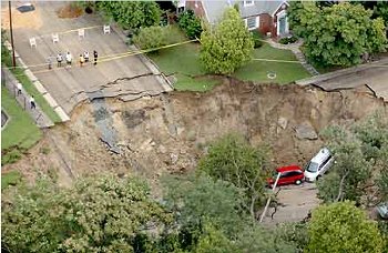
Heavy
rain from remnants of tropical storm Gaston caused a sinkhole
in Richmond, VA.
(Times-Dispatch/Mark Gorman) |
The rain washed out roads and bridges and sent a torrent of water
into the low-lying district, closing restaurants, bars and old tobacco
warehouses converted into condos and apartments.
The governor, who viewed the flood-ravaged
area on Tuesday, asked President Bush for a federal disaster declaration
for the cities of Richmond, Hopewell, Colonial Heights and Petersburg,
and the counties of Chesterfield, Dinwiddie, Hanover, Henrico and
Prince George.
Jamison said inspectors had already condemned 19 buildings, and
electricity to 70 buildings was disconnected because of damaged
systems.
"The magnitude of a storm of this level you can't imagine
until you have to go in and clean up," he said. "They're
going to rebuild, and the city is going to be stronger than it is
now. That's our track record."
Three more deaths were confirmed Wednesday, officials said. In
suburban Henrico County, police found the body of a woman who apparently
was swept away by floodwaters after abandoning her car. In Dinwiddie
County south of Richmond, a person had been carried away by rushing
water during an attempted rescue. In Richmond, a man's body was
found in Broad Rock Creek.
More than 100 roads remained closed, the state
Transportation Department said, and another 40 Richmond streets
that remained blocked. At least six bridges were washed out.
"There may be a few more, but until the water recedes, we're
not going to know," state Transportation spokeswoman Linda
South said. "That's how bad it is out there."
|
| The smudges of dark blue on this
Envisat-derived ozone forecast trace the start of what has unfortunately
become an annual event: the opening of the ozone hole above the
South Pole.
"Ever since this phenomenon was first discovered in the mid-1980s,
satellites have served as an important means of monitoring it,"
explained José Achache, ESA Director of Earth Observation
Programmes. "ESA satellites have been routinely observing stratospheric
ozone concentrations for the last decade.
"And because Envisat's observations are assimilated into
atmospheric models, they actually serve as the basis of an operational
ozone forecasting service. These models predict the ozone hole is
in the process of opening this week."
Envisat data show 2004's ozone hole is appearing about two weeks
later than last year's, but at a similar time period to the average
during the last decade. The precise time and range of Antarctic
ozone hole occurrences are determined by regional meteorological
variations. |
AMIDON, N.D. - A fire in the Badlands
burned about 4,000 acres and sent flames 80 feet into the air Thursday,
and fire officials feared the blaze could quickly grow because of
high winds and drought conditions.
"We have a very serious fire here," Forest Service spokeswoman
Colleen Reinke said. "The fire weather is expected to be very
severe today. It is zero percent contained."
"In the worst-case scenario, this has the potential to go
to 10,000 acres," she said.
The fire, burning in a sparsely populated area full of dry grass
and timber in southwestern North Dakota, began Wednesday afternoon.
The fire was caused by people, although the exact cause was under
investigation, said Ron Jablonski, a ranger for the U.S. Forest
Service. [...] |
| MELBOURNE, Fla. (AP) - Bracing
for a monstrous storm, residents and tourists clogged shelters or
made last-minute preparations Friday as Hurricane Frances churned
toward the Atlantic coast, where the state's second pummeling in
three weeks could begin as soon as Saturday. About 2.5 million residents
were ordered to evacuate - the largest number in state history.
The slow-moving storm's core was now expected to hit Florida Saturday
afternoon or evening, instead of early Saturday as had been earlier
predicted.
Frances had weakened Friday into a strong Category 3 storm packing
120 mph winds and the potential to push ashore waves up to 14 feet
high. Its top sustained winds were down from about 145 mph on Thursday,
but forecasters said the weakening could be fluctuation typical
with large storms and Frances could regain its former strength.
If it did, it could be the worst storm to hit the state since
Andrew in 1992. [...] |
| (CNN) -- As Hurricane Frances
bears down on the United States, weather trackers are sounding the
alarm. Yet Frances may only be the first in a series of large, powerful
storms to march across the Atlantic in coming years.
The arrival of hurricanes like Charley and Frances within weeks
of each other is a rare anomaly, but some meteorologists say more
storms like Frances -- both very intense and very large -- are possible.
"Over the past few years, we've seen an
increasing trend toward greater activity in the Atlantic Basin and
increased strength in storms," said Marshall Shepherd, a research
meteorologist at NASA's Goddard Space Flight Center. "[That]
has been leading us to believe that we are going to start seeing
more intense hurricanes. That may be bearing itself out right now."
A combination of natural cycles and warming
ocean temperatures from global warming may be fueling the destructive
storms. Scientists like Shepherd employ an array of satellites,
aircraft and computer models to answer those questions in their
mission to comprehend the Earth's climate. [...]
Disaster coordinators still advise those in the potential path
of many hurricanes to evacuate. Although measures can be taken to
secure property, little can be done against the worst hurricane
winds that can exceed 150 mph and send floodwaters many miles inland.
"[With] enough money, you can build buildings resistant against
the wind," said Andy Coburn, associate director of the Duke
University program for the study of developed shorelines. "The
force of water is completely different. We don't have the technology
or the economic feasibility that can withstand the forces of moving
water."
America's infatuation with coasts, and the dense population centers
on the Eastern Seaboard, mean that it will not escape hurricanes'
wrath. If storm intensity and frequency pick up, the country could
be in for a wild ride.
Coburn offered only one solution. "Get the
hell out of the way," he said. |
| (CNN) -- As Hurricane Frances
bears down on the United States, weather trackers are sounding the
alarm. Yet Frances may only be the first in a series of large, powerful
storms to march across the Atlantic in coming years.
The arrival of hurricanes like Charley and Frances within weeks
of each other is a rare anomaly, but some meteorologists say more
storms like Frances -- both very intense and very large -- are possible.
"Over the past few years, we've seen an increasing trend
toward greater activity in the Atlantic Basin and increased strength
in storms," said Marshall Shepherd, a research meteorologist
at NASA's Goddard Space Flight Center. "[That] has been leading
us to believe that we are going to start seeing more intense hurricanes.
That may be bearing itself out right now."
A combination of natural cycles and warming ocean temperatures
from global warming may be fueling the destructive storms. |
| 
STUART, Fla. (AP) - Hurricane Frances crashed ashore
at Florida's east coast early Sunday with sustained wind of 105
mph and pelting rain, knocking out power to 2 million people and
forcing Floridians to endure a frightening night amid roaring gales
that shredded roofs and uprooted trees.
The National Hurricane Center said the eye of the
hurricane officially made landfall near Sewall's Point, just east
of Stuart - about 40 miles north of West Palm Beach - at about 1
a.m.
Transformers popped along streets, sending sparks
into darkened skies, as families huddled in shelters, bathrooms
and hotel lobbies. The wind-whipped coastal waters resembled a churning
hot tub.
In Melbourne, 65 miles north of Stuart, the wind
and rain looked like a giant fire hose going off at full blast.
"I've never seen anything like
this, and no one in my family has," said Darlene Munson, who
was riding out the storm with family members at her Melbourne restaurant.
The storm's slow-motion assault - Frances was crawling
at just 8 mph - came more than a day later than predicted. The western
portion of the hurricane's eye crept over parts of the east-central
Florida coast Saturday night, with its strongest winds hitting early
Sunday.
"Those folks are getting pounded, and they've
got worse to come," said Max Mayfield, director of the National
Hurricane Center.
A hurricane warning remained in effect for nearly
300 miles along Florida's east coast, from Florida City north to
Flagler Beach, including Lake Okeechobee.
A continued slow west-northwestward motion was expected
to move the entire eye of the hurricane inland by sunrise, the weather
service said.
Maximum sustained wind was near 105 mph with higher
gusts. There was little chance of strengthening before the eastern
half of the eye moved inland, the weather service said.
Hurricane force winds extended up to 85 miles from
the center, and tropical storm-force winds, which range from 39
mph to 73 mph, extended up to 200 miles.
Coastal storm surge flooding of 4 to 6 feet above
normal tide levels, along with large and dangerous battering waves,
were expected near and to the north of Stuart. Storm surge flooding
of 5 feet above normal levels was expected in Lake Okeechobee.
Florida Power & Light, the state's
largest electric company, said power outages to its customers affected
2 million people. Nearly all of Vero Beach, 30 miles north of Stuart,
was blackened, the city's utility said.
In Martin County, where Stuart is located, 630 people
taking shelter at a school had to move to another shelter when part
of the roof blew off, flooding 16 rooms. More than 300 people were
able to remain in the school.
Four people were hospitalized in Boynton Beach after
breathing carbon monoxide fumes from a generator that was running
in a house. No other injuries were immediately reported.
En route, Frances shattered windows, toppled power
lines and flooded neighborhoods in the Bahamas, driving thousands
from their homes. The Freeport airport was partially submerged in
water. At least two deaths in the Bahamas were blamed on the storm.
For many Floridians, this would be a night to remember.
Mary Beth and Jack Stiglin, evacuees from nearby
Hutchinson Island, sat in their hotel room in Fort Pierce, eating
ham and cheese wraps by candlelight as the power lines outside their
room sparked and died.
"It's a little romantic. I brought the roses
from our garden because they would have been blown away anyway,"
Mary Beth Stiglin said.
Frances' arrival came three weeks after Hurricane
Charley killed 27 people and caused billions of dollars in damage
in southwestern Florida.
For some Floridians, the second storm couldn't arrive
soon enough.
"I just want it to be quick. Just get it over with," said
Woodeline Jadis, 20, tired of waiting at a shelter in Orlando.
The storm's leading edge pounded the Florida coast
early Saturday. Frances was so big that virtually
the entire state feared damage from wind and water. Forecasters
said the storm would dump 8 to 12 inches of rain, with up to 20
inches in some areas.
"This is the time to show some resolve and not
be impatient," Gov. Jeb Bush said. "This is a dangerous,
dangerous storm."
In Washington, President Bush declared a major disaster
in the counties affected by Frances, meaning residents will be eligible
for federal aid.
The largest evacuation in state history,
with 2.8 million residents ordered inland, sent 80,000 residents
and tourists into shelters. The storm shut down much of Florida,
including airports and amusement parks, at the start of the usually
busy Labor Day weekend.
Some evacuees, frustrated by Frances' sluggish pace,
decided to leave shelters Saturday and return later.
Deborah Nicholas dashed home from a Fort Pierce shelter
to take a shower, but stayed only a few minutes when the lights
started flickering and trees began popping out of the ground. She
has slept in a deck chair at a high school cafeteria since Wednesday.
"I'm going stir crazy," Nicholas said.
"I'm going to be in a straitjacket by Monday. I don't know
how much longer I can take it. Have mercy."
Residents could take comfort that Frances weakened
as it lingered off the coast. Forecasters downgraded it to a Category
2 hurricane as sustained winds receded to 105 mph, down from 145
mph earlier. But the heavy rain forecast still threatened to cause
widespread flooding, and the outer bands of the storm packed plenty
of punch.
In Palm Bay, winds pried off pieces of a banquet
hall roof, striking some cars in the parking lot. Trees were bent
and light posts wobbled in the howling gusts.
In Fort Pierce, the storm shredded awnings and blew
out business signs. Many downtown streets were crisscrossed with
toppled palm trees.
One gust reached 115 mph at Fort Pierce, according
to the National Hurricane Center, damaging the mast of a truck measuring
the storm's intensity. Florida Power & Light pulled crews off
the streets because of heavy wind, meaning those without power would
have to wait until the storm subsided, utility spokesman Bill Swank
said.
In Stuart, traffic lights dangled, and one hung by
a single wire. Downed trees blocked at least one residential street,
and signposts were bent to the ground. The facade at a flooring
store collapsed, as did the roof of a storage shed at a car dealership.
Roads, streets and beaches were mostly deserted -
the occasional surfer notwithstanding. Roads were littered with
palm fronds and other debris. Businesses were shuttered and even
gas stations were closed, their empty pumps covered with shrink
wrap.
Not everyone stayed home: Two men were charged with
looting for trying to break into a Brevard County church.
As the weather worsened, a yacht adrift on the Intercoastal
Waterway struggled for more than half an hour in choppy water to
anchor in West Palm Beach before tying up to a dock. Other boats
bobbed like toys. A U.S. Coast Guard helicopter rescued a man and
his cat riding out the storm on a sailboat anchored in Biscayne
Bay.
At Palm Beach International Airport, the roof and
a door were blown off a hangar.
The storm extended vacations for about 10,000 passengers
on nine cruise ships unable return to Florida ports on schedule.
They were expected to arrive late Sunday or Monday.
Kevin Palmer, a photographer in Palm Beach County,
said the wind blew so hard at his front door that it was making
the copper weather stripping around it vibrate and shriek violently.
"It's become our high-gust alarm," Palmer
said. "It sets the tone for your ambiance when you've got the
rumbling outside, you have this screeching from the weather stripping
and you keep wondering if that thumping you just heard is another
tree going over or a coconut going flying."
Frances was expected to push across
the state as a tropical storm just north of Tampa, weaken to a tropical
depression and drench the Panhandle on Monday before moving into
Alabama.
In the central Atlantic Ocean, the ninth named storm
of the season grew stronger Saturday. Tropical Storm Ivan was about
1,355 miles east-southeast of the Lesser Antilles with winds of
70 mph. Forecasters expect Ivan to become a hurricane with winds
of at least 74 mph on Sunday and to continue to strengthen. |
| STUART, United States (AFP) -
Tropical storm Frances killed two as it crossed Florida, authorities
said, as yet another hurricane loomed in the far distance.
The deaths occurred Sunday in the city of Gainesville in north-central
Florida, 386 kilometers (240 miles) northwest of Stuart, which lies
on the state's hard-hit Atlantic coast.
A man died when he lost control of his car and hit a tree, and
a woman was killed when an oak tree fell on her mobile home, Captain
Beth Hardee of Alachua County Fire and Rescue said.
Their deaths bring the total storm toll to four thus far. Two
people died in the Bahamas when Hurricane Frances battered the Atlantic
island chain for more than 30 hours Thursday and Friday.
Gainesville was still under driving rain and high gusting wind
early Monday, some 22 hours after the storm first entered the area,
Hardee said.
"I've lived in Florida all my life and I've
never experienced a storm like this," she said.
The remnants of the eye of Frances have moved off Florida's west
coast, but "it's trying to reform. It could build up strength
again" over the warm waters of the Gulf of Mexico. [...]
But Florida, which is barely recovering from the devastation wrought
last month by Hurricane Charley, was warily eyeing yet another hurricane,
which loomed on the far horizon.
Hurricane Ivan, a dangerous Category 4 storm packing
maximum sustained winds of nearly 215 kilometers (135 miles) per
hour, was a thousand kilometers away, but long-term forecasts put
it dangerously close to the US state by the end of the week.
Early Monday, Ivan was 1,010 kilometers (625 miles) east-southeast
of Barbados, which issued a hurricane watch.
As Ivan headed toward the Caribbean windward islands, Frances
lost steam as it crossed Florida, though forecasters said it could
regain hurricane strength over the Gulf of Mexico on Monday. [...] |
| An international scientific team
which has been drilling beneath the bed of the Arctic Ocean says
it enjoyed a sub-tropical climate 55 million years ago.
The Arctic Coring Expedition (Acex) has recovered sediment cores
from nearly 400m (1,300ft) below the sea floor.
It says fossilised algae in the cores show the sea temperature
was once about 20C, instead of the average now, -1.5C.
The expedition, which has relied on three icebreakers during its
work, is now heading back to Tromso in Norway.
Unlocking the Arctic's history
The scientists, from eight nations, recovered the cores from below
the sea floor in waters 1,300m (4,260ft) deep.
Acex has been taking cores from the Lomonosov Ridge between Siberia
and Greenland. The ridge, 1,500km (930 miles) long, rises to 800m
(2,625ft) below sea level and is topped by 450m (1,475ft) of layered
sediments.
The scientists said before they set sail from Tromso last month
their findings would help science to work out how long the Arctic
sea ice, now in retreat, had persisted.
The cores they have extracted show the Arctic Ocean was once a
subtropical, shallow sea. The evidence, Acex says, is in the form
of tiny algal fossils found in the cores, which were once marine
plants and animals.
They date back to a period known as the Palaeocene-Eocene thermal
maximum, a brief period that occurred around 55m years ago.
Huge die-off
It was characterized by an extremely warm climate that created
a natural greenhouse effect, which caused massive amounts of carbon
to be deposited in both sea and air Atmospheric carbon levels then
are thought to have been about 2-3,000 parts per million (ppm),
compared with almost 380 ppm today.
The algae found in the Lomonosov cores, which lived only in subtropical
conditions, prove how warm the Arctic once was, Acex says. It says
the ocean's temperature was once similar to the waters off New York
in August.
Dr Michael Kaminski, a palaeontologist from University College
London, UK, said: "We're seeing a mass extinction of sea-bottom-living
organisms caused by these conditions.
"Moving forward in time, we see many species disappear. Only
a few hardy survivors endure the thermal maximum."
There is also evidence that part of the Arctic Ocean was once
a freshwater lake, probably when the Lomonosov Ridge was part of
what is now Siberia.
The last 250,000 years of Arctic history were known already in
some detail thanks to cores taken from the Greenland ice cap.
Coping with Nature
But Professor Jan Backman of Stockholm University, one of the
two chief scientists of Acex, said: "We now have sediment records
going back to 56m years, which are resting on 80-million-year-old
bedrock.
"The early history of the Arctic Basin will be re-evaluated
based on the scientific results collected on this expedition."
Acex has had to contend with natural hazards, including an ice
shelf up to 10m (33ft) thick which threatened drilling operations
before a Russian icebreaker demolished it.
The drilling ship was also approached by two polar bears, capable
of climbing over its low sides, and had to scare them off by sounding
its hooter.
The Acex scientists are to meet again in November at the University
of Bremen in Germany to examine the data.
Acex is part of the Integrated Ocean Drilling Program (IODP) and
is conducted by the European Consortium for Ocean Research Drilling.
A group of European scientific institutions, Ecord Science Operator,
is responsible for fleet management, ice and weather monitoring,
and science operations.
The British Geological Survey co-ordinates Ecord Science Operator,
and the Natural Environment Research Council is a member of IODP.
|
| ST. GEORGE'S, Grenada - Hurricane
Ivan grew into the deadliest of storms overnight Thursday, packing
winds of 160 mph as it made a beeline for Jamaica after pummeling
Grenada, Barbados and other islands, causing at least 15 deaths.
As dazed survivors emerged from half-destroyed homes in Grenada
— where at least 12 people were killed and 90 percent of the
100,000 islanders' homes were damaged — Jamaican leader P.J.
Patterson urged his people to pray.
"We have to prepare for the worst case scenario. Let us pray
for God's care," Patterson said Wednesday night. "This
is a time that we must demonstrate that we are indeed our brothers'
and sisters' keeper."
The most dangerous storm to hit the Caribbean in years already
pummeled Barbados and other islands Tuesday before setting its deadly
winds and rains, blamed for three other fatalities in Barbados,
Tobago and Venezuela, on a course projected to take it directly
over Jamaica, Cuba and into the heart of the hurricane-weary southern
United States.
The storm strengthened early Thursday to become a Category 5 on
a scale of 5. It packed sustained winds of 160 mph with higher gusts
as it passed north of the Dutch Caribbean islands of Aruba, Bonaire
and Curacao. [...] |
MIAMI - Tourists and residents
were told Thursday to leave the Florida Keys to avoid mighty Hurricane
Ivan, even as Floridians still struggled with the destruction and
misery left by Hurricanes Frances and Charley.
Forecasters said Ivan — which strengthened
early Thursday to 160 mph — could reach the island chain as
early as Sunday, making it the third hurricane to hit Florida in
a month.
Charley struck southwest Florida on Aug. 13 with wind of 145 mph,
causing an estimated $6.8 billion in damage and 27 deaths. Frances
hit the state's eastern coast early Sunday with 105 mph wind, leaving
$2 billion to $4 billion in insured damage and at least 15 dead
in the state.
Ivan has already killed at least 15 people
as it tears through the Caribbean, the most powerful hurricane to
hit there in a decade. Ninety percent of the homes in Grenada
were damaged, looting erupted and a prison was destroyed, leaving
criminals on the loose.
At 8 a.m., Ivan's center was about 455 miles southeast of Kingston,
Jamaica, or about 1,000 miles southeast of Miami. It had top sustained
winds of 160 mph.
National Hurricane Center forecasters predict that Ivan could
hit the Florida Keys as a Category 4 hurricane, with winds of 131
to 155 mph, late Sunday or early Monday. [...]
Remnants of Frances continued to create problems Thursday.
In Ohio, where up to 7 inches of rain fell, two deaths were attributed
to the storm. In Asheville, N.C., tens of thousands of people remained
without drinking water early Thursday after a major water line from
a reservoir washed out. [...] |
The death toll from Typhoon Songda
rose to 31 Wednesday, with at least 14 people still missing and
more than 900 injured mainly in Hokkaido and western Japan. [...]
Hokkaido felt the full force of the typhoon, the agency said.
The city of
Sapporo experienced winds of up to 180 kph before noon. [...]
Airlines canceled 106 domestic flights and two international flights
Wednesday, affecting more than 14,000 passengers. On Tuesday, 82
domestic flights and two international flights were scrubbed, affecting
nearly 13,000 travelers.
Songda is the seventh typhoon to land on Japan proper this year,
breaking the record of six in a single season. [...]
Songda followed close behind Typhoon Chaba, which left at least
13 people in Japan dead, and Megi, which killed at least 10. |
| KEY WEST, Florida (AP) -- Before
Florida could catch a breath from a furious hurricane double-whammy,
residents of the Keys were sent scurrying under new evacuation orders
Friday as yet another powerful storm was taking aim at the state.
In South Florida, long lines reappeared at gas stations while
shoppers snapped up hurricane supplies at home building stores and
supermarkets in preparation for the possibility of a third strike
in a month -- this time by Hurricane Ivan, which forecasters said
could slam Florida's narrow island chain as early as Monday. The
state has not been hit by three hurricanes in a single season since
1964.
Still busied with recovery efforts from hurricanes Frances and
Charley, Gov. Jeb Bush said workers would redouble their around-the-clock
efforts. "We're not worried about hurricane amnesia anymore,"
he said. "We're worried about hurricane anxiety." [...]
|
| WASHINGTON (AP) -- A mild El
Nino is developing in the Pacific Ocean, climate experts said Friday.
El Ninos can affect weather in other areas, sometimes worldwide.
"El Nino conditions have developed in the central tropical
Pacific and are expected to last through early 2005," Jim Laver,
director of the federal Climate Prediction Center, said in a statement.
These conditions occur when ocean waters become warmer than normal
for the area, causing an increase in cloudiness and affecting air
pressure and winds as well. [...]
The climate scientists said sea surface temperatures were more
than 0.5 degrees Celsius (1 degree Fahrenheit) above average in
the central and western equatorial Pacific during August 2004, the
third month of warmer-than-normal readings.
While the current warming indicates the early stages of an El
Nino, the conditions have not spread ocean wide, which means it
is likely to be weaker than the 1997-1998 event, the agency said.
El Ninos occur about every four to five years and can last up
to 12 to 18 months. The effects can range from drought in Indonesia,
Australia and Africa, to storms in California and floods elsewhere.
The 1997-98 El Nino caused an estimated $20 billion
in damage worldwide. |
Charley, Frances and Ivan. Three
major hurricanes. Two assaults on Florida already and possibly a
third by next week. Get used to it. This is the new normal.
Scientists say we are in a period of enhanced hurricane activity
that could last for decades, ending a 24-year period of below-average
activity.
They add the law of averages has caught up with Florida, with
a change in atmospheric steering currents turning the state into
a hurricane magnet.
If Hurricane Ivan hits the state, it will be the first time since
1964 that three hurricanes smacked Florida in the same year.
And September and October tend to be among the most-active months
of the six-month hurricane season that ends Nov. 30.
"The season is still young," said Max Mayfield, director
of the National Hurricane Center in West Miami-Dade County. "It
certainly seems from my perspective that we're in the active period
that has been predicted.
"The only surprise is that Florida hasn't been hit more often
in the last few years," Mayfield said.
Research Goldenberg conducted with NOAA scientist Chris Landsea,
private expert William Gray and others found distinct patterns of
low-activity hurricane periods and high-activity periods, each of
which endured for decades.
One period of "hyperactivity" ended in 1970 and was
followed by a 24-year lull.
The new period of heightened activity began in 1995 and could
last for another 10 to 30 years, according to Goldenberg's report,
which was peer-reviewed and published in 2001 in the prestigious
journal Science. |
Disastrous weather is set to continue
for at least another six months, it was officially announced yesterday,
as Hurricane Ivan headed for the Cayman Islands and Cuba after leaving
at least eight people dead in Jamaica.
The US government confirmed that a new El Niño is about
to strike, bringing torrential rain and droughts around the world.
Meanwhile, Ivan developed winds of 155mph. Jamaica escaped a direct
hit, but still suffered extensive damage. So far, at least 34 people
have lost their lives, mostly in Grenada.
Over the next two days both Tony Blair and Michael Howard - in
an unprecedented double act - will make major speeches describing
climate change as one of the greatest threats facing civilisation.
They will set out programmes for combating global warming, and call
for the rapid development of clean, renewable sources of energy.
Niños usually kill more people worldwide even than bad
hurricane years, and the announcement by the US government's National
Oceanic and Atmospheric Administration (Noaa) presages more natural
and human disasters stretching at least into the early months of
next year.
"El Niño conditions have developed in the tropical
Pacific and are expected to last through early 2005," said
Jim Laver, director of the Noaa's Climate Prediction Centre.
During an El Niño, warm water flows eastwards
across the Pacific, bringing heavy rain to the US West Coast and
most of Central and South America. By contrast Australia, Indonesia
and parts of north-east and southern Africa usually suffer drought.
Europe is relatively unaffected.
The last big El Niño in 1997-98 cost
hundreds of lives and caused $34bn (£19bn) in damage worldwide,
partly through flooding to Chile, Ecuador and Bolivia and
partly through failing harvests in Australia, the Philippines and
Indonesia. A more recent, milder one in 2002-03 caused the worst
Australian drought in a century.
So far, the new one looks more like 2002-03 than 1997-98 but climatologists
stress that all are different. The oceanic phenomena, like hurricanes,
are growing more frequent. Research suggests
that they are occurring nearly three times as often as 300 years
ago, and some scientists believe that there is a link with global
warming. [...]
|
Another week, another hurricane. Is this
year unprecedented?
Just about. The only time on record
that anything like this happened before was in 1947, when two
hurricanes and one tropical storm hit Florida within five weeks.
In the 38 years since 1966 only one hurricane - Andrew in 1992
- hit the state before last month.
Anything else?
Yes, since you ask. August saw a record number
of tropical storms so big that they were given names. Eight of
them. And the US suffered 173 tornadoes last month, easily outstripping
the previous record of 128.
Is this the end of it?
Unlikely. Friday marked the half-way point
in the hurricane season. Prof William Gray of Colorado
State University, one of the world's top hurricane forecasters,
predicts at least one more this month. But he foresees a quiet
October, partly because another disturbance - El Niño -
is gathering pace in the Pacific, and this tends to suppress hurricanes
in the Atlantic.
Haven't there been rather a lot of hurricanes over the last
few years?
Yes, indeed. The years since 1995 have been the
worst on record. And experts predict it will go on for decades
more.
What's going on?
A combination of factors must combine to make a hurricane. These
include thunderstorms, distance from the Equator, and particular
wind conditions. But one of the most vital
is warm seawater: the Atlantic is very warm this year.
So it's all down to global warming?
Hard to say. There are natural cycles in the temperature of the
oceans. But most scientists agree that hurricanes will get stronger
as the world warms up. Whether they will be more frequent is a
much more open question.
|
| ATHENS (AFP) - Thousands of migratory birds
in the Greek nature reserve of Lake Koronia have died in recent
months in what birds specialists are calling "an ecological
catastrophe," several sources said.
Hundreds of dead gulls, tern and ducks -- at least 15 species in
all -- were discovered just in the last few days, the sources said
Thursday.
Autopsies and tests of water samples from the lake are underway,
but experts do not yet know what is responsible for the sudden wave
of avian fatalities, described by Xenofon Kappas, spokesman of the
Greek ornithological society, as "a major ecological catastrophe."
"For the moment, we are in the process of counting the number
of dead birds," Kappas told AFP.
The Greek news agency ANA put the Lake Korina avian death toll
at 3,000, but experts said that more than 10,000 dead birds have
been found on the lake in recent months.
The Mayor of Salonika, 520 kilometers (320 miles) north of Athens,
adopted "emergency measures" to deal with the crisis,
reported ANA, and water samples have been sent to Salonika University
for testing. Fishing has also been banned, though no dead fish have
been found.
Lake Korinia is one of 27 parks in Greece that are part of the
Natura 2000, a European Union-sponsored network of bird sanctuaries
and threatened habitats.
The Lake is also one of 10 Greek ecological sites protected by
the Ramsar treaty, and international convention on wetland ecosystems
adopted in the mid-1970. |
| Hurricane Ivan has strengthened
as it heads towards Cuba after bringing destruction to the tiny Cayman
Islands.
Southern Cuba has been feeling the first effects of Ivan's winds,
and the island's western tip is expected to take the full force
later on Monday.
Meanwhile, the low-lying Cayman Islands have reportedly suffered
enormous damage, with large areas under water. [...]
Reuters reported people clambering on to kitchen counters and roof
tops as waist-high storm surges aided by 160mph (260km/h) winds
swept across the island.
Warning
The US National Hurricane Center said Ivan had strengthened to
the most dangerous category five level as it moved from the Cayman
Islands on to Cuba. [...]
Hurricane Ivan is the sixth-strongest storm to ever hit the Atlantic
basin, the National Hurricane Center has said. |
| LONDON (Reuters) - Britain's Tony
Blair pledged on Tuesday to force international action on global warming,
despite the reluctance of big powers like the United States.
Blair promised to make the issue a centerpiece of Britain's presidency
of the G8 industrialized countries in 2005 and laid out a three-point
international strategy to tackle a phenomenon he said could become
"irreversible in its destructive power."
Blair pointed to violent weather conditions across the globe this
year and said the richest countries created most of the problem
while the poorest bore the brunt.
"It is the poorest countries in the world that will suffer
most ... yet it is they who have contributed least to the problem,"
Blair said in a speech to experts in London.
"That is why the world's richest nations in the G8 have a
responsibility to lead the way."
Bush dismayed many allies in 2001 by pulling the United States
out of the U.N.'s Kyoto protocol, the main international pact meant
to cap emissions of greenhouse gases.
America is the biggest emitter of greenhouse gases.
Blair said Kyoto was only a first step but noted that the last
time the U.S. Senate voted on the issue, it was unanimously against
it. "I doubt time has shifted the numbers very radically,"
he admitted. |
| PINAR DEL RIO, Cuba (AP) - Hurricane
Ivan whipped western Cuba with 257-kilometre-an-hour winds, ripping
the roofs of tobacco barns and houses and drenching fields before
moving into the Gulf of Mexico on Tuesday, threatening offshore
oil rigs and setting off an exodus along the U.S. coast.
Five Florida counties and a Louisiana parish urged or ordered residents
to leave Tuesday as Ivan spun out of the Caribbean. One of the fiercest
storms ever recorded in the region, Ivan cut a deadly swath through
Grenada, Jamaica and the Cayman Islands, killing at least 68 people.
In Mexico, hundreds of people abandoned fishing settlements on
the Yucatan peninsula, and the resort city of Cancun opened shelters
and closed beaches. Cozumel island, a dive resort known for its
lumbering sea turtles, shut its airport and halted cruise ship arrivals.
[...]
Cuba's tobacco crop was safe, according to top grower Alejandro
Robaina. Planting season doesn't begin until next month and remnants
of January's harvest are protected in curing houses. Tobacco is
the communist-run island's third-largest
export, producing an average of 150 million cigars worth about $240
million US a year. Sugar, the lead export, was spared since much
of the cane is grown in the east. |
| OVER GEORGE TOWN, Cayman Islands - Expensive
yachts were beached, tossed to the shore like toys. Well-built homes
were reduced to splintered wood, or left without roofs. Utility
poles and palm trees were snapped in two or uprooted.
Widespread destruction was visible from an airplane chartered by
The Associated Press that overflew the island Monday, the day after
Hurricane Ivan struck the Cayman Islands.
On Grand Cayman's famed Seven Mile Beach, one hotel was partially
smashed. Many others were damaged, including some missing roofs.
Debris was everywhere.
Animals congregated on higher ground to escape the flood. Some
century-old trees three stories tall were torn up by their roots.
Although the runway at Grand Cayman had been cleared of debris
and floodwaters, the AP charter was not allowed to land because
access was restricted to approved flights and those carrying in
emergency supplies.
There were no reports of injury or death — but there were
poignant stories of survival.
On Grand Cayman, one firefighter rescued a family in danger, handed
an infant by a parent standing shoulder-deep in floodwaters.
Just recounting the incident, which was relayed from firefighters,
choked up Pilar Bush, tourism director of the British territory
that was slammed by the fiercest hurricane it has experienced in
more than 60 years.
"It just made me think of 9/11," Bush said in a telephone
interview from New York, where her government sent her to meet with
the media in case of disrupted communications.
Telephone service failed when Hurricane Ivan
pounded the island with winds and gusts up to 200 mph but
spared it a direct hit, leaving Bush in sporadic contact with the
government.
Thousands of people are homeless on Grand Cayman, the capital of
a territory of 45,000, she told the AP, because of significant damage
to between one-quarter and one-half of the homes there.
The government was looking at available hotels and school dormitories
to house the displaced people, she said. Soup kitchens were set
up Monday on the island known for its offshore banking and well-heeled
tourists.
"I don't even know if my family's alive," Bush said,
citing the sporadic communications.
The Caymans — a group of three islands that
draw hundreds of thousands of tourists and cruise ship passengers
a year — have not experienced a storm of this ferocity since
1932.
In that year, an era before hurricanes were given names, one storm
made a direct hit, taking hundreds of lives.
Many died on Cayman Brac, what is known as a "sister island."
They took shelter in caves on higher ground but then left their
refuge in the calm when the eye passed over — only to be struck
by the fierce winds from other side of the eyewall.
For Ivan, hundreds of Caymanians again fled again to the caves.
They were reported safe on Monday, Bush said. |
| MIAMI - Tropical Storm Jeanne formed Tuesday
in the Atlantic Ocean Tuesday and was expected to hit Puerto Rico
with strong wind and heavy rain by Wednesday morning.
The National Hurricane Center posted tropical storm warnings for
Puerto Rico, the U.S. and British Virgin Islands, St. Kitts and
Nevis.
Jeanne could be packing sustained wind of 60 mph and drop 9 inches
of rain when it hits Puerto Rico, center forecasters said.
"It's not the same as Ivan, but it is certainly threatening
weather," forecaster Rafael Mojica said.
At 2 p.m. EDT, Jeanne had top sustained wind of nearly 50 mph and
was expected to strengthen. It was centered about 100 southeast
of St. Croix in the U.S. Virgin Islands and was moving west-northwest
at about 10 mph.
Forecasters said the storm could hit or skim past
the Dominican Republic on Thursday, Haiti on Friday and move over
the eastern tip of Cuba or into the Bahamas by Saturday. There is
a chance the storm could hit Florida early next week. Mojica said
it could become a Category 1 hurricane with sustained wind topping
74 mph by Saturday.
Jeanne is the 10th named storm to form in the Atlantic this tropical
storm season, which began June 1. Three have hit Florida, and Ivan
is threatening to hit the Gulf Coast this week.
Hurricanes Charley and Frances caused up to $20 billion in damage
to Florida and killed at least 50 people. Tropical Storm Bonnie
caused minimal damage when it struck the Panhandle. |
MEXICO CITY (AFP) Sep 14, 2003
Hurricane Javier strengthened as it churned off Mexico's Pacific coast
Monday, with winds at 195 kilometers (120 miles) per hour, the national
weather service said.
Javier was spotted 455 kilometers (280 miles) southwest of Manzanillo,
Colima, in western Mexico, traveling at 17 kilometers (10 miles)
per hour.
Meanwhile, deadly Hurricane Ivan threatened Mexico's Gulf coast,
located 220 kilometers (145 miles) east of Cancun, after killing
69 people as it tore through the Caribbean. |
| WASHINGTON - With Hurricane Ivan threatening
the Gulf Coast and cleanup still under way after hurricanes Charley
and Frances, the Federal Emergency Management Agency has issued
42 disaster declarations so far this year.
While that's above normal, it does not approach the record 75 disaster
declarations of 1996. By this date in 1996, there had been 63 disasters
declared nationwide.
FEMA said Tuesday it has received 353,716 claims for help from
Florida residents battered by Charley and Frances. [...] |
| SHANGHAI, China (AP) - Tropical
storm Haima buffeted eastern China as authorities evacuated 120,000
people as a precaution against danger from flooding and landslides.
Heavy rains and strong winds were forecast for Tuesday, though
there were no reports of damages or injuries as the storm moved
slowly inland through Zhejiang province, southwest of Shanghai.
State media reported that local authorities declared a state of
high alert and relocated 120,000 people ahead of the storm, the
21st of the season. Workers were rushing to shore up flood dikes.
Haima, the Chinese name for sea horse, brought torrential rains
and winds of 55 kilometres per hour as it passed over northern Taiwan
on Sunday. The storm triggered a mudslide that buried a Taiwanese
family of four and flooded thousands of homes.
Parts of Taiwan, Japan and eastern China are still recovering from
flooding and mudslides triggered by a series of storms that have
swept through the region during this year's typhoon season. |
(CP) - New antibiotic-resistant
pathogens, airborne mercury and urban sprawl are threatening the
health of the Great Lakes and millions of people who live around
the bodies of fresh water, a report to the Canadian and U.S. governments
concludes.
While there has been a general improvement in water quality over
the past 30 years, the International Joint Commission report released
Monday warns new and emerging threats require urgent attention.
"Without adequate safeguards, our health can be threatened
by pathogens and disease-bearing micro-organisms," the report
states.
"The governments must focus increased attention on protecting
the sources of drinking water supplies."
Dennis Schornack, American co-chairman of the commission, said
the frequent use of antibiotics in livestock and humans is causing
the problem.
Bacteria can develop immunity to the drugs, then end up in drinking
water and cause illness, he said.
"We've got to become better at monitoring pathogens in the
water and examine whether the waste-water treatment plants that
we have in place are successfully killing the organisms," Schornack
said.
Herb Gray, the commission's Canadian co-chairman, said the best
way to tackle the problem is to curb the use of antibiotics.
The biennial report recommends better management of watersheds
to mitigate the impact of agriculture, development, industry and
urbanization - a daunting task.
"There are a large number of problems still to be dealt with,"
Gray said.
"(They) are large-scale. They'll require large amounts of
money over an extended period of time."
Another threat identified in the report is airborne methyl-mercury,
which ends up in the water. Most comes from regional coal-fired
power generators, but some comes from as far as China.
Other chemicals, such as fire retardants commonly used for furniture,
are posing new threats.
"Chemical contamination continues to endanger human health
and restricts the number of fish we can safely eat," Gray said.
Another area of concern is the ongoing problem posed by alien
species brought in by the ballast water of foreign ships.
Currently, about one new invasive species takes hold every eight
months.
While there have been some successes in controlling their proliferation,
none have ever been eradicated.
Still, Schornack said he believes overall water quality in the
lakes has improved in recent decades.
As an example, he noted Lake Erie is now far healthier than it
was 30 years ago.
However, the emergence of unexplained dead zones in the lake has
raised new worries.
"We're very concerned about Lake Erie, not only for Lake
Erie itself but for what it could be a harbinger of for the other
lakes," Gray said. [...] |
| NEW ORLEANS - Some beach towns were deserted
Wednesday and highways leading to higher ground were jammed as Hurricane
Ivan roared toward the Gulf Coast with 140 mph.
Nearly 200 miles wide, Ivan could cause significant damage no matter
where it strikes, as hurricane-force wind extended up to 105 miles
out from the center. Hurricane warnings were posted along a 300-mile
stretch from Grand Isle, La., across coastal Mississippi and Alabama
to Apalachicola, Fla.
"We're leaving today. All this is going under," said
a surfer Chuck Myers who was only taking pictures of the waves Wednesday
morning at Gulf Shores. "We surfed it all day yesterday. It
was glorious."
"This is a bad one and people need to get out," Mobile,
Ala., Mayor Mike Dow said Wednesday on ABC's "Good Morning
America." [...] |
| FLORENCE, Miss. - Fleeing northward from Hurricane
Ivan, Angela Zimmerman and her mother and son, evacuees from Mobile,
Ala., spent the night in their minivan somewhere in the woods of
south Mississippi, then awoke early Wednesday and formed a prayer
circle.
"God's going to protect us. We prayed this morning before
we left, so we know that's taken care of," Zimmerman, 33, said
at a gas station about 20 miles south of Jackson.
Northbound U.S. 49 between the Mississippi
Gulf Coast and Jackson was bumper-to-bumper Wednesday with people
who had fled coastal areas of Louisiana, Mississippi, Alabama and
the Florida Panhandle. Hotels were booked solid as far north as
Memphis, Tenn., nearly 325 miles northwest of Mobile. [...]
|
| NEW ORLEANS - The worst-case scenario for
New Orleans — a direct strike by a full-strength Hurricane
Ivan — could submerge much of this historic city treetop-deep
in a stew of sewage, industrial chemicals and fire ants, and the
inundation could last for weeks, experts say.
If the storm were strong enough, Ivan could drive water over the
tops of the levees that protect the city from the Mississippi River
and vast Lake Pontchartrain. And with the city sitting in a saucer-shaped
depression that dips as much as 9 feet below sea level, there would
be nowhere for all that water to drain.
Even in the best of times, New Orleans depends on a network of
canals and huge pumps to keep water from accumulating inside the
basin. [...] |
| SAN JUAN, Puerto Rico - Tropical Storm Jeanne,
nearing hurricane strength, slammed into Puerto Rico on Wednesday
as rivers rose, roads flowed with torrents of water and frantic
residents evacuated low-lying areas.
Lashing rains and wind blew plants off terraces and felled trees
as the storm's eye made landfall on the southeastern tip of the
island Wednesday afternoon.
"The biggest concern for Puerto Rico is flashflooding and
mudslides," said Hector Guerrero, a meteorologist at the National
Hurricane Center in Miami.
Streets in the tourist hub of colonial Old San Juan were deserted
and most flights had been canceled. The largest mall in the Caribbean
— Plaza las Americas — was also shut and Gov. Sila Calderon
prohibited alcohol sales for the day to keep citizens alert.
The storm's projected path had it potentially
reaching hurricane-weary Florida, Georgia and South Carolina either
Sunday or Monday. [...] |
| MEXICO CITY (AFP) - Western Mexico was pounded
by heavy rain and strong winds from the outer reaches of Hurricane
Javier, a powerful Category Four system, as the storm hurtling
north across the Pacific Ocean.
At 1400 GMT, Javier was some 375 kilometers south-southwest of
Manzanillo, a port town in the state of Jalisco, moving at seven
kilometers (four miles) per hour with winds of 230 kph (143 mph)
and gusts of 285 kph (177 mph), Mexico's Meteorological Service
(SMN) said.
"The hurricane is causing rain in Jalisco and the states of
Colima and Nayarit, but, in its current course, it is not expected
to reach land in the next hours," SMN meteorologist Sonia Castellon
said.
Authorities have urged residents in Pacific states to follow news
on the storm's path, since hurricanes are "always unpredictable,"
Castellon said. [...] |
| BANGKOK (AFP) - Flash floods have killed two
people in northern Thailand, leaving thousands either stranded or
forced to abandon their homes, media reported, as the capital braced
for potential flooding.
Torrential rain in northeastern Chiang Rai province claimed the
lives of a 45-year old policeman and 78-year-old farmer Tuesday,
and forced more than a dozen villages to be evacuated and some schools
closed, said the Nation newspaper.
The daily said flooding had also forced the evacuation of homes
in Chiang Mai and Ubon Ratchathani provinces, and Bangkok officials
have set up a flood operations centre amid concern that parts of
the nation's capital could also be submerged by the deluge.
Forecasters have predicted some of the heaviest
rainfall for Thailand in recorded history with flooding already
having affected more than half a million people in the past few
months.
Adverse weather conditions have caused widespread flooding in much
of East and South Asia since June, the World Meteorological Organization
(WMO) reported last month.
Among the countries worst hit are Bangladesh, where hundreds have
died, China, India, Japan, both Koreas, Nepal, the Philippines and
Vietnam.
The WMO said a combination of factors including
abnormal monsoons and tropical cyclones were behind the problems. |
| BEIJING, Sept. 13 (Xinhuanet) -- Experts attending
the International Symposium on Sand and Dust Storms (SDS) noted
here Monday that the developing trend of the storms is not optimistic,
and that they are likely to affect more places in the world.
Beijing has been tortured by horrible sand and dust storms since
1999. However, the spring was much cleaner and windless in 2003,
and many optimistically thought that the terrible weather phenomenon
would disappear from the capital.
The holders of this opinion may be discouraged by Dr. Tan Jiqing,
Director of the Institution of Meteorological Information and Prediction
of Disaster Events attached to Zhejiang University, who said analysis
and computation on the sand and dust storms should integrate all
factors -- including sand content, area coverage and destruction
-- not simply count occurrences.
Tan added that sand and dust storm often ebb after several strong
years, and last year might have been an example of that.
The severe situation in the northern and northwestern parts of
China this year shows the problem is still there, said the expert.
Actually, sand and dust storms are influencing an increasing number
of places on the globe year by year, said Tan after his research
on the long-term observation results. [...] |
| AUSTIN, Minn. (AP) - Emergency workers in
boats rescued people from cars and homes left stranded by rising
water Wednesday as heavy rain doused southern Minnesota and caused
flash flooding.
Schools and roads were closed, a nursing home was evacuated and
fields were flooded. A car was swept away by rushing water moments
after its driver got out of the vehicle, Mower County Sheriff Terese
Amazi said.
"We've got major flooding, it came up quick," Amazi
said. Rain began Tuesday and ended by late Wednesday morning.
In Austin, 145 kilometres south of Minneapolis, the Cedar River
overflowed its banks, forcing the city to close some streets and
forcing nearby residents to flee. The Spam Museum - a tourist draw
in Austin, where Hormel Foods is located - was evacuated.
Gov. Tim Pawlenty, who surveyed the damage by helicopter, said
he was "somewhat taken aback by the magnitude of it."
He said flooding severely damaged crops, schools and homes.
"The worst may not yet be over," he added. The river
was expected to crest later Wednesday. [...] |
|
The bomber crashed soon after take-off
A long hot summer in Iceland has revealed previously hidden parts
of a British warplane that crashed on a glacier in May 1941.
The Fairey Battle bomber has been re-emerging slowly from the ice
since 1995, monitored by aviation enthusiast Hordur Geirsson.
"For the first time, we have seen the engine," he told
BBC News Online.
"This summer has been unbelievably warm and the winter was
mild. Three metres of ice has disappeared since spring."
Four servicemen died in the crash: a New Zealand-born Flight Officer,
Arthur Round, and three British airmen - Flight Sergeant Keith Garrett,
Flight Sergeant Reginald Hopkins and Pilot Officer Henry Talbot.
[...] |
| (AP) - Ivan, Frances and Charley delivered
three staggering blows to the U.S. Gulf Coast and Florida, as well
as Caribbean island countries, all in just five weeks.
Now here comes Jeanne, which could be lashing north Florida and
Georgia by Monday. Homeowners ritualistically re-hammering the same
plywood over their windows figure it can't get much worse, right?
Brace yourselves: Scientists say 65 million Americans living on
the Gulf and Atlantic coasts should expect weather like this for
another 30 years. Maybe more.
Sure, it's hurricane season and storms happen. But counting Alex,
which swamped the Carolinas in August, that's five in six weeks.
And that doesn't include tropical storms Bonnie, Gaston, Earl and
Hermine.
"I don't remember this happening before in
such a short period of time," National Hurricane Center director
Max Mayfield told reporters, "and the season is only half-over."
It might be a generation before hurricane weather slips back into
a quiet phase, he and other experts say.
"The hurricane threat is much greater than it was in the
1970s through early 1990s," said federal meteorologist Stan
Goldenberg, who flew around hurricane Ivan in research aircraft
as it approached Mobile, Ala. "It could last another 10 to
40 years."
Goldenberg and other experts believe the current hurricane surge
is part of an obvious storm cycle that probably has been waxing
and waning for hundreds of years.
Roughly from 1970-94, Atlantic hurricane activity in the United
States was relatively mild. Sure, there were monster hurricanes
like Andrew in 1992. Its 285 kilometre-per-hour winds killed 55
people in the U.S. and Caribbean and caused $26.5 billion US in
damage. Every year a big storm whips up; it's just that most fizzle
before veering into a city.
Overall, the 25-year "quiet" period generated about
half as many destructive storms as the previous stormy phase dating
back to the 1920s, and about half as many as today's stormy phase
appears likely to produce.
Since 1995, environmental conditions have shifted and the Atlantic
has been spawning more strong storms. The number of major hurricanes
has more than doubled. In the Caribbean, it's up by a factor of
five.
Even with milder storm years in 1997 and 2002, the period since
1995 is the most active nine consecutive years on record, according
to pioneering hurricane forecaster William Gray at Colorado State
University.
Since 2000, the United States has been hit by an average of four
powerful storms per season.
Forecasters have been warning of this for years. Even back in
1998, a year that saw four hurricanes in September, Gray said: "We
are going to see the return of some of these type of storms. People
have to face up to it. The insurance industry has a major problem."
Last month, Gray tweaked his gloomy 2004 forecast downward, predicting
13 named storms rather than 14. He expected seven storms to blow
up into hurricanes, three with sustained winds of 178 km/h or greater.
So far, he's right. If storms continue brewing, Gray might wish
he had tweaked his forecast up, not down. And don't forget that
last year, two more tropical storms developed in the Caribbean after
the hurricane season formally ended Nov. 30.
Why is the storm cycle intensifying now? Scientists aren't certain
what causes the decades-long shifts in the ocean-atmosphere interplay.
Hurricanes reflect the complex dance between the atmosphere and
the oceans.
When the Pacific Ocean cools during the La Nina climate phenomenon,
the Atlantic warms up, and more hurricanes are the result. Over
the Atlantic, wind shear that knocks down rising storms tend to
slacken, while humid westerly winds from Africa's bulge grow stronger.
Scientists look for large pools in subtropical ocean where water
is at least 27 C. The warm sea heats the air in a rising column,
creating a centre of moist low pressure.
Trade winds rush in toward this depression. Combined with the
planet's rotation, they spin clouds counterclockwise around this
steamy core, or "eye" of the storm.
Most scientists agree that global warming plays little or no role
in the number of storms in the current hurricane cycle.
Global climate models show that air pollution from industry and
traffic will drive up average world temperatures by up to one degree
Celsius this century. All that extra heat could fuel more stormy
weather. And local evidence of temperatures rising may already be
apparent with some glaciers melting and spring flowers blooming
early. But so far, climate change is too uncertain and today's hurricane
patterns are too complex to draw a connection.
"I don't think the warming now is anywhere near enough to
account for the increase in hurricanes that we're seeing,"
said Robert Gall of the National Center for Atmospheric Research
in Boulder, Colo. "To me, this is just a natural variation
in the frequency of hurricanes."
Hurricanes are among nature's most powerful natural events. Spinning
as fast as a race car, the wall of clouds can rise 15 kilometres
into the stratosphere and span more than 600 kilometres, as wide
as Kansas.
The amount of mechanical energy generated by a such a swirling
storm translates to a power supply of 360 billion kilowatt hours
per day. That's equal, by some estimates, to all of the electricity
consumed in United States in six months.
Only 12 per cent of the world's swirling storms spawn in the Atlantic.
About 100 of these cyclones are reported annually worldwide. Most
of them crank unnoticed in the North Pacific and the Indian Ocean.
A large storm might seethe and spin for 5,000 kilometres, inhaling
the energy from billions of tonnes of warm seawater. Incoming dry
air from high pressure zones can choke it off, or landfall can quickly
deflate it.
Forecasters are much less comfortable predicting how a storm will
behave once it hits land. That's a major focus of their research
now. |
| A white-breasted eagle on the Parramatta River.
Photo: Nick Moir
The only sea eagles nesting on the Parramatta River have both been
found dead, possibly after consuming fish contaminated with deadly
toxins.
The environmental disaster could not have come at a worse time.
It is believed the pair were incubating eggs in their newly constructed
nest near the Silverwater Bridge.
Although they live in one of the nation's most heavily contaminated
environments, last year the birds, which were only in their second
breeding season together, managed to fledge their first chick. They
had appeared to be in good health and because they both died at
the same time it is unlikely to have been the result of long-term
exposure to pollution.
Sea eagles are among the biggest predators in Sydney and a popular
attraction at Olympic Park. But their territory takes in a part
of the estuary considered so poisoned that fishing is illegal. [...] |
| SPRING CITY, Tenn. (AP)--Heavy rain and wind
from what was once Hurricane Ivan assaulted the southern Appalachian
Mountains on Friday, washing away homes and killing at least 10
people in the region.
Hundreds of thousands of people lost power, and flash flood warnings
stretched along the mountain chain from northern Georgia up to southern
Ohio and western West Virginia.
Already, water swamped businesses in Tennessee, Georgia and North
Carolina. Major flooding and 3.7 inches of rain were reported in
Asheville, N.C. The city of 69,000 was also hard-hit in Hurricane
Frances' aftermath last week, losing drinking water for days.
About 20 miles west, in the rural Canton area, water rose as high
as 4 feet inside a convenience store, and a paper plant was again
flooded.
"We've been working two weeks trying to get it back running,''
said Earl Medley, a contractor at the plant.
In rural eastern Tennessee, rushing water from a creek cascaded
through Spring City, breaking out storefront windows, carrying away
merchandise and leaving behind a muck of mud and debris.
Mayor Mary Sue Garrison said a Coke machine also went floating
down the street. "It was just really, really terrible,'' said
Garrison, wearing a yellow rain slicker as she walked through the
town.
Business owners were spending the morning shoveling the soggy
mess out of their establishments.
"It's a complete disaster area,'' Officer B.J. Neal said.
"We've had homes completely destroyed. We've had homes washed
in the lakes.''
Garrison said gauges in the town, which has a population of about
2,000, showed 8 1/2 inches of rainfall since Thursday. But no serious
injuries were reported. [...]
Ivan, now a tropical depression, was blamed for three deaths in
northern Georgia, including a 6-year-old girl who was swept away
in flooding in Cleveland. She died despite a rescue attempt by her
teenage sister, who herself had to be saved by a neighbor, a county
emergency official said.
Six deaths were reported in North Carolina, including two when
a house collapsed in Macon County, in the state's southwestern corner.
Another person died when a tree fell onto a house in Henderson County,
south of Asheville, troopers said.
In Tennessee, a 25-year-old police officer in Harriman, about
35 miles west of Knoxville, crashed on a rain-slick road late Wednesday
while returning from a routine patrol.
About 210,000 homes and businesses lost power in Georgia, including
160,000 in the Atlanta area. Power was also out to more than 164,000
homes and businesses in North Carolina and 23,000 in South Carolina.
Those numbers could rise as the storm continued, officials said.
Tennessee emergency officials reported only scattered power outages
affecting up to 2,000 customers.
As much of 8 inches of rain fell in western North Carolina, where
high water or downed trees closed more than 100 roads, and more
than 200 people were evacuated from areas near rivers.
After the rain came, rescue workers in the state used helicopters
to aid people caught in swift-flowing water, said Maj. Chris Simpson
of the North Carolina National Guard.
Before Ivan arrived, batteries and bottled water had vanished
from Asheville stores.
"I went to the grocery store for normal stuff, but there's
nothing there,'' said James Browne, a waiter at the Flying Frog
cafe in downtown Asheville.
Atlanta had 5 inches of rain, and much of northern Georgia's Gilmer
County was under water, said Lisa Ray, spokeswoman for the Georgia
Emergency Management Agency.
"There have been some motor homes that have floated off,''
Ray said.
In South Carolina, there were several reports of tornadoes in Oconee
County, and one person was slightly injured when a tree was blown
onto a mobile home, county emergency director Henry Gordon said.
Ahead of the storm, Virginia Gov. Mark R. Warner declared a state
of emergency. Heavy bands of heavy rain lashed Virginia's mountainous
southwestern tip, still waterlogged from previous rains. |
| Ecuador will not submit to mediation
in New York as proposed by US oil giant Texaco, from which indigenous
people here are seeking billions of dollars in damages for alleged
environmental harm to their land, the South American country's top
law enforcement officer said Friday.
The Amazon basin region's four indigenous peoples -- the Siona,
the Huaorani, the Cofan, and the Shuar -- in July 2003 took on Texaco
in the Ecuadoran courts, seeking reparation for alleged damages
to half a million hectares (1.24 million acres) of sacred lands.
They put the cost of cleaning up at six billion dollars.
Texaco maintains it already has cleaned up in the area.
Ecuadoran Attorney General Jose Maria Borja told foreign correspondents
Texaco's proposal for mediation in New York was "incompetent,
immoral and inappropriate because it is an affront to the sovereignty
of our country."
He said Texaco was trying to force state oil company Petroecuador
to pick up the tab for the damage allegedly inflicted ovber 20 years.
"That damage should be repaired by Texaco," Borja said.
A New York court in May 2003 said the case should be handled in
Ecuador's courts. |
| Some 825,000 people have been stranded
by floodwaters in northeastern Bangladesh after a second swollen river
burst its banks and poured into hundreds of villages, officials said
Saturday.
An earth embankment along the Kakri river in Comilla district gave
way, washing away 130 houses instantly and damaging 500 more homes,
government relief officer Abu Bakar Siddique told AFP.
Some 325,000 people in the area are camping in the open on high
ground such as roads and embankments or are stranded in their flooded
homes, he said.
He said the deluge was triggered on September 10 and water remained
waist-high in most places.
"Those people are in great misery living on streets or some
high lands without adequate food supply," Siddique said.
Some 500,000 people have already been affected by floods elsewhere
in the same district after the Gomoti river flooded into more than
350 villages. |
| ANCHORAGE, Alaska - Biologists remain baffled
by the death of hundreds of seabirds in early July at False Pass
in the eastern Aleutian Islands.
The die-off of more than 250 puffins, cormorants, kittiwakes,
seagulls and eiders may have been caused by bacteria, parasites,
marine biotoxins or unusual virus, said Dr. Rex Sohn, wildlife disease
specialist for the U.S. Geological Survey's National Wildlife Health
Center in Madison, Wis. Tests have shown no evidence of West Nile
virus, Sohn told the Anchorage Daily News.
Other test results are still to come in, but it is possible the
cause will not be found, he said.
"That's not uncommon in wildlife diseases," Sohn said.
"We don't have people out there that can tell us what the birds
were doing in the two, three, five days before they died. Were they
at False Pass or somewhere else? What were they eating? ... We don't
have the histories on these birds."
On the July Fourth weekend, False Pass residents found dead birds
washed up on the beach and floating in the strait beyond the village.
Tammy Shellikoff, assistant administrator of the False Pass Tribal
Council, said she counted "over 250, but that didn't cover
all of the birds floating in the water."
More tufted puffins died than other species.
"That caused a lot of heartache because the puffins normally
survive well," Shellikoff said. "We just didn't know what
was going on. Was this something we were going to have as a longtime
problem?"
The die-off appeared to end as suddenly as it began. |
| WHEELING, W.Va. - Hundreds of people evacuated
their homes Sunday in parts of Ohio, West Virginia and Pennsylvania
as rivers and small streams were swollen beyond their banks by the
torrential rain dumped by remnants of Hurricane Ivan.
The Ohio River inundated parts of Wheeling and other West Virginia
river towns, as well as communities on Ohio's shore, and the Delaware
River flooded parts of New Jersey and eastern Pennsylvania.
In addition to flooding, more than 1.2 million
homes and businesses were still without electricity early Sunday
from Florida to Pennsylvania because of Ivan, utilities estimated.
The hurricane and its remnants had been blamed
for at least 50 deaths in the United States, 19 of them in Florida,
and 70 deaths in the Caribbean.
West Virginia Gov. Bob Wise asked President Bush on Sunday to declare
eight northern counties federal disaster areas. "The Northern
Panhandle clearly has been devastated and meets the threshold,"
Wise said after flying over the region.
The Ohio River crested Sunday at Wheeling at about 8.5 feet above
flood stage, more than 2 feet below the forecast, but it had already
submerged the city's riverfront park and amphitheater, and mostly
covered the city's midriver Wheeling Island, which holds residential
neighborhoods and Wheeling Island Racetrack and Gaming.
Wise spent the night with evacuees on the gym floor at Wheeling
Park High, one of several Red Cross shelter sites, after a brief
tour of the area by road.
"I saw mobile homes uprooted and tossed downstream,"
he said. "I saw human lives uprooted."
Downriver, residents had been urged to evacuate parts of Moundsville,
and big flood gates were closed at Parkersburg.
All around West Virginia, flooding and mudslides had blocked 207
roads and damaged hundreds of houses, authorities said.
About 1,700 people were out of their homes Sunday in eastern Ohio,
where the Ohio River was rising to at least 6 feet above flood level,
authorities said.
In Ohio's Jefferson County, mudslides and flooding closed a section
of highway along the river, said a deputy who would not give his
name. And in the southeastern Ohio city of Marietta, streets were
underwater near the river, but no details were available Sunday
morning, an emergency dispatcher said.
Hundreds of New Jersey and Pennsylvania residents fled their homes
along the Delaware River on Sunday. Several bridges that cross the
Delaware between the two states were blocked by high water, and
emergency officials said the river was not expected to crest until
evening.
At Phillipsburg, N.J., state police helicopters were used to monitor
a propane tank and a house that were floating down the river, authorities
said.
"It was one of the most amazing things I've seen," said
Sgt. Gerald Lewis.
The central Pennsylvania city of Williamsport
collected 6.5 inches of rain in 24 hours Friday, and Pittsburgh
got a record 5.95 inches. Some areas of Pennsylvania reported up
to 9 inches, state officials said.
The Susquehanna River was nearly 8 feet above flood stage Sunday
morning at Bloomsburg, Pa., the National Weather Service said. Dozens
of homes in Scranton and Old Forge were evacuated as well as the
western tip of Bloomsburg. The Susquehanna had forced hundreds from
their homes in Jersey Shore, between Williamsport and Lock Haven.
In western Pennsylvania, the Monongahela and Allegheny rivers crested
Saturday night at 6 feet above flood stage at Pittsburgh, where
they join to form the Ohio River. That was a half-foot lower and
two hours sooner than forecast. |
| Officials spread out across Maryland and Virginia
on Saturday to survey damage done by Tropical Depression Ivan, which
spawned tornadoes and dumped rain on an already-saturated area.
Despite the damage, the area seemed to escape much of the severe
precipitation, flash flooding, and mudslides that Friday's storms
were predicted to bring. But plenty of people lost power.
Virginia-Dominion Power spokeswoman Leha Anderson says winds have
been blowing steadily at speeds of about 25 miles per hour with
occasional higher wind gusts since early Saturday morning. That's
knocking down tree limbs and disrupting service from Arlington to
Springfield. Anderson says there are also outages in Alexandria,
Fairfax, Falls Church and Leesburg.
Anderson says although service was restored to most areas that
suffered outages because of tornadoes last night, there are still
about 20,000 customers without service because of the relatively
high winds today. As crews restore service in some areas, additional
calls about outages and downed lines continue to come in.
More than 40 tornadoes were reported in Virginia
during the storms, but were yet to be confirmed officially, said
Dawn Eischen, spokeswoman for the state Department of Emergency
Management. The National Weather Service was investigating, she
said.
"They're doing damage assessments in different localities
that have had tornadoes and damage, and are sending reports to us,"
Eischen said.
The National Weather Service is sorting through three more in Maryland.
Despite a large amount of property damage,
only a few people were injured. Fauquier County reported
two injuries, Frederick County reported two and Fairfax County one,
Eischen said.
National Guard units have been mobilized
in Virginia, where Governor Mark Warner declared the third weather-related
state of emergency in almost five weeks. [...]
Lightning from Ivan may be responsible for a hangar fire at Leesburg
Municipal Airport. The blaze heavily damaged one hangar and spread
to a second building, while destroying one private plane and damaging
another. Despite the loss of planes and hangar buildings, Leesburg
airport officials reported no injuries to staff. The damage estimate
is expected to go well over a quarter of a million dollars. [...]
Heavy rain fell in many parts of already waterlogged Virginia with
more forecast through Saturday. The National Weather Service posted
flood watches for 42 localities in the state. [...]
Tornados also struck Western Maryland. A tornado tore the roofs
off two houses in Frederick County Friday, and at least two more
confirmed twisters struck the area. No injuries were reported.
Trees and power lines were downed, and the entire state was under
a flood watch through Saturday. [...]
In Washington County, funnel clouds were reported near the state
prison complex south of Hagerstown. A tree landed on a house in
the area, causing a partial collapse, said Verna Brown of the county's
emergency management coordinator.
He said any flash flooding of smaller streams appeared to be most
likely in the western mountains, where up to 6 inches of rain were
expected to fall through Saturday.
The weather threat prompted the National Park Service to cancel
two Civil War re-enactor encampments planned for Saturday night
near Sharpsburg. One was to have been held at the Ferry Hill Plantation
on the Chesapeake & Ohio Canal. The other was planned in conjunction
with a scrapped torchlight tour of the Antietam National Battlefield.
[...]
|
| TORONTO - A U.S.-Canada
body that regulates water use in the Great Lakes has proposed new
rules that could open the door to large diversions to the U.S.,
experts fear.
The Council of Great Lakes Governors, which represents eight states,
Ontario and Quebec, said it has proposed rules that will:
• Require any new or increased diversions from the lakes
to improve the environment.
• Use a "uniform, resource-based decision making standard"
to assess proposals for new or increased water uses.
• Make decisions collectively about new water uses in Great
Lakes regions.
"This is a giant step toward protecting, conserving, restoring
and improving the Great Lakes Basin and reflects the governors and
premiers commitment to work together for the long-term benefit and
protection of this precious natural resource," the council's
website says.
While the proposal has attracted little public attention, a Washington
research institute recently published two comments on the issue.
Ralph Pentland, an Ottawa-based consultant, said
in a recent paper on the Woodrow Wilson Center website that one
part of policy "is tantamount to a 'Water for Sale' sign."
"The water marketing industry, in whatever form it takes
with a world water crisis, has been handed over 'liquid gold,'"
U.S. environmental lawyer James M. Brown said.
The Council of Canadians will oppose the plan at a public hearing
in Toronto on Monday, Canadian Press reported.
About 45 million people, including 10 million Canadians, live
in the Great Lakes basin. |
| More and more people are being caught up in
a growing number of natural disasters, a UN agency said on Friday.
The International Strategy for Disaster Reduction said the increase
in numbers vulnerable to natural shocks was due partly to global
warming.
It said 254 million people were affected by natural hazards last
year - nearly three times as many as in 1990.
The assessment comes as the Caribbean and the US are being hit
by a series of devastating hurricanes.
Events including earthquakes and volcanoes, floods and droughts,
storms, fires and landslides killed about 83,000 people in 2003,
up from about 53,000 deaths 13 years earlier, the ISDR said.
Releasing its statistics jointly with the Centre for Research on
the Epidemiology of Disasters (Cred) at the University of Louvain
in Belgium, it said there was a consistent trend over the last decade
of an increasing number of people affected by disasters.
There were 337 natural disasters reported in 2003,
up from 261 in 1990.
"Not only is the world globally facing more potential disasters
but increasing numbers of people are becoming vulnerable to hazards,"
the ISDR said.
The problems, it said, are exacerbated because more and more people
are living in concentrated urban areas and in slums with poor building
standards and a lack of facilities.
ISDR director Salvano Briceno added that urban migrants tended
to settle on exposed stretches of land either on seismic faults,
flooding plains or on landslide-prone slopes.
"The urban concentration, the effects of climate change and
the environmental degradation are greatly increasing vulnerability,"
he said.
"Alarmingly, this is getting worse."
|
| GONAIVES, Haiti (AP) - Tropical Storm Jeanne
brought raging floodwaters to Haiti, killing at least 90 people
in the battered nation and leaving dozens of Haitian families huddled
on rooftops as the storm pushed further out into the open seas on
Sunday, officials said.
Floods tore through the northwestern coastal town of Gonaives
and surrounding areas, covering crops and turning roads into rivers.
U.S.-backed interim Prime Minister Gerard Latortue and his interior
minister toured the area in a U.N. truck Sunday, but were not able
to reach many areas because of washed out roads.
"We don't know how many dead there are," Latortue said.
"2004 has been a terrible year."
Workers with the Catholic humanitarian agency Caritas Internationalis
picked up 62 bodies in pickup trucks and counted another 18 at a
morgue in Gonaives alone, said Rev. Venel Suffrard, the organization's
local director. Suffrard said he expected the toll to rise.
The floods killed another 10 people in other parts of the country,
mostly in the northwest, said Dieufort Deslorges, a spokesman for
the Haitian Ministry of Interior.
A World Health Organization worker said he had toured parts of
downtown Gonaives and saw people pushing wooden carts filled with
cadavers. "There is no life left in the center of town,"
U.N. health worker Pierre Adam said.
The deaths came four months after floods killed more than 3,000
people on the Haitian-Dominican border. In February, a three-week
rebellion ousted President Jean-Bertrand Aristide and left about
300 dead.
Several people were reported missing and feared dead. Unlike the
Dominican Republic, much of Haiti is deforested and unable to hold
back floodwaters.
At 11 p.m. EDT, Jeanne was 180 miles east-southeast of the Bahamian
island of San Salvador, moving northward near 8 mph. Storm-force
winds strengthened to 60 mph and stretched up to 85 miles from its
center.
Jeanne didn't appear likely to hit the storm-battered southeastern
United States. It was expected to turn south over the next two days
and head back out into the Atlantic, away from Florida and other
states that have been battered by three major storms already this
season. |
| Two hang-gliders were blown out of the sky
and more than 100 nursing home residents relocated last night after
a severe hail and rain storm swept parts of Sydney, the Central
Coast and the Hunter Valley.
Budgewoi, Toukley and Erina on the Central Coast were hardest
hit by the storm, the NSW Fire Brigades said.
A nursing home at Erina suffered extensive roof damage, and 102
patients were moved to another wing.
Razorback, between Camden and Picton, was pelted with hailstones
the size of 10-cent pieces. The storm swept from the west, over
Liverpool and Blacktown. Hail also fell on Katoomba and Sydney's
northern beaches.
The State Emergency Service had received more than 300 calls for
help by late last night, a spokesman said.
Near Otford, at the southern end of the Royal National Park, a
sudden change in the weather forced two hang-gliders to land abruptly
about 3pm. The hang-gliders suffered back and leg injuries. An air
search and rescue patrol spotted them later.
One was winched to safety by helicopter and taken to St George
Hospital. The other was taken to the same hospital by ambulance.
The Bureau of Meteorology attributed the hail production to strong
updraughts and moist air.
The State Emergency Service said spring and summer were peak seasons
for thunderstorms and hail.
It urged residents to clean gutters and clear items from balconies
and gardens if they risked blowing around and causing injury. Householders
were also warned to keep battery-operated radios on hand for use
during any loss of power. |
| IQALUIT - Violent winds brought down power
lines and damaged buildings in communities in Arctic Quebec and
Nunavut on Tuesday.
Flags were flapping wildly as the winds picked up speed in Iqaluit,
Nunavut's capital.
Further north in Igloolik on Baffin Island, winds were blowing
at over 100 kilometres an hour on Tuesday afternoon.
Power lines are down in one area of town, and some homes are without
electricity.
"Those poles went down, wires touching each other, we get
outages when they touch," says Jasen Aqqiaruq, who works for
the Nunavut power corporation in Igloolik.
Hurricane-force winds gusting up to 118 kilometers an hour caused
extensive damage earlier today in Salluit, a community of 1,800
people in northern Quebec.
Mayor Michael Cameron says sheds were toppled over and some were
destroyed. A garage workshop and fuel storage tank were demolished,
and windows were smashed on some houses.
Cameron says luckily no one was hurt.
"We asked our citizens to stay indoors, we contacted businesses
and organizations to shut down their doors and we asked that the
nursing station with the social services be on alert," he says.
Cameron says it will take weeks to clean up the mess.
He says Inuit elders in Salluit say they've never experienced
winds like this in the fall.
Environment Canada says a deep low pressure system moved up from
Manitoba.
It's causing erratic weather such as blizzards, thunderstorms
across Nunavut.
The pressure system is expected to decrease slowly during the
night. |
| MIAMI - Hurricane Karl weakened slightly Tuesday
and stayed on an open-ocean course that only threatened ships, while
Tropical Storm Lisa became stronger far out in the Atlantic.
Karl, the seventh hurricane this season, had top sustained winds
near 120 mph, according to the National Hurricane Center in Miami.
Forecasters did not expect the storm's strength to change over the
next day.
At 5 p.m. EDT, Karl was centered about 990 miles east-northeast
of the northern Leeward Islands in the Caribbean and was moving
north-northwest near 16 mph.
Karl followed Hurricane Jeanne, which was northeast of the Bahamas
and moving southeast at 6 mph, but did not immediately threaten
any land. Jeanne was blamed for at least 620 deaths in Haiti, where
it hit as a tropical storm and caused flooding.
At 5 p.m., Lisa had top sustained winds near 70 mph, just below
the 74 mph threshold to become a hurricane. Forecasters said Lisa
was a small storm and its wind speed was expected to fluctuate.
The 12th named storm of the season was centered about 1,090 miles
west of the Cape Verde Islands and was moving west-northwest near
8 mph.
Residents in the Caribbean should monitor Lisa, which was heading
in their direction although it was still about a week away, forecasters
said.
The hurricane season ends Nov. 30. |
| MIAMI - Deadly Hurricane Jeanne could head
back toward the United States and threaten the storm-battered Southeast
coast, including Florida, as early as this weekend, forecasters
said Wednesday.
It was too soon to tell where or if Jeanne would hit, but forecasters
at the National Hurricane Center in Miami warned residents from
Florida to Maryland to watch the storm with 90 mph top sustained
winds.
Some computer models had Jeanne curving out to sea and missing
land, but others had it hitting the United States on Saturday or
Sunday, forecasters said.
Jeanne was blamed for more than 700 deaths in
Haiti, where it hit over the weekend as a tropical storm and caused
flooding. It had been moving out to sea, but appeared to be looping
back toward land, forecasters said.
At 11 a.m. EDT, Jeanne was centered about 530 miles east of Great
Abaco Island in the Bahamas. It was moving south near 5 mph, but
was expected to head west by early Thursday.
Dangerous surf and rip currents along with large swells are possible
along the southeastern U.S. coast over the next few days, forecasters
said. If Jeanne hit Florida, it would follow Hurricanes Charley,
Frances and Ivan, which caused billions of dollars of damage and
more than 60 deaths across the state.
Meanwhile, Hurricane Karl weakened slightly and stayed on an open-ocean
course that only threatened ships, while Tropical Storm Lisa moved
slowly far out in the Atlantic.
Karl, the seventh hurricane this season, had top sustained winds
near 105 mph, down from about 120 mph a day earlier. At 11 a.m.,
Karl was centered about 1,490 miles west-southwest of Fayal Island
in the Western Azores and was moving north near 14 mph.
At 11 a.m., Lisa had top sustained winds near 50 mph, down from
about 70 mph a day earlier. The 12th named storm of the season was
centered about 1,165 miles west of the Cape Verde Islands and was
moving west-northwest near 6 mph.
The hurricane season ends Nov. 30. |
| BROOKLIN, Canada (IPS) - Hurricane Ivan, the
incredibly powerful storm that killed at least 120 people in the
Caribbean and southern United States, may be a harbinger of the
Earth's hotter future, say experts.
"As the world warms, we expect more and more intense tropical
hurricanes and cyclones," said James McCarthy, a professor
of biological oceanography at Harvard University.
Large parts of the world's oceans are approaching 27 degrees C
or warmer during the summer, greatly increasing the odds of major
storms, McCarthy told IPS.
When water reaches such temperatures, more of it evaporates, priming
hurricane or cyclone formation. Once born, a hurricane needs only
warm water to build and maintain its strength and intensity.
Over the last 100 years, the Earth has warmed by about .6 degrees
C, according to the 2001 report by the Intergovernmental Panel on
Climate Change (IPCC), an international scientific body that studies
the relationship between human activity and global warming.
The IPCC report was based on research by more than 2,500 scientists
from about 100 countries who determined that emissions of gases
such as carbon dioxide act as a blanket that prevents much of the
sun's energy from dissipating into space.
Much of the extra energy from this "greenhouse effect"
is being absorbed by the oceans.
The "proof" that the oceans are warming is the fact
that global sea levels have risen 3.1 cm in the past 10 years, said
Kevin Trenberth, head of the Climate Analysis Section at the National
Center for Atmospheric Research in Boulder, Colorado.
Water expands when heated, and sea levels are expected to continue
rising by as much as 50 cm by 2100. [...] |
| MIAMI - The remnants of deadly Hurricane
Ivan, which rampaged through the Caribbean and then into the U.S.
Gulf Coast a week ago, killing more than 100 people, have reformed
in the Gulf of Mexico as a tropical storm threatening the Texas
and Louisiana coasts.
By 8 a.m. EDT on Thursday, Ivan was about 95 miles southeast of
Cameron, Louisiana, with top winds of 45 mph, the U.S. National
Hurricane Center said.
It was moving west-northwest at about 15 mph on a course that would
likely take its core ashore on the northeastern Texas coast in the
next day, the center said.
Ivan could strengthen before coming ashore and was expected to
dump as much as 10 inches of rain in its path.
Ivan, at one point one of the most powerful Atlantic hurricanes
on record, made a devastating 10-day trek through the Caribbean
before hurtling ashore in the United States near Gulf Shores, Alabama,
just west of the Florida Panhandle. [...] |
| CHICAGO - At a time when restaurants typically
put away their patio furniture, sweaters replace T-shirts and sailboats
are plucked from the water, Midwesterners are out enjoying activities
usually reserved for July and August — not weeks past Labor
Day. Summer is here. Finally.
"We're getting the summer we never had and now we're making
up for it," said Bill Snyder, who produces the weather segments
of the WGN-TV news in Chicago.
Alyssa Theisen certainly did. The 4-year-old, wearing a dress,
darted right into a fountain in Chicago's Millennium Park on Wednesday,
surprising her mother.
"She just ran into the water," Angie Theisen said. "I
didn't bring her (swim) suit. I thought it was too late."
At Chicago's Monroe Harbor on Lake Michigan, sailors thought the
water would be a lot less crowded.
"Very few boats are gone for the season," said Joe Williams,
the harbor master. "The weather is keeping them in the water."
Blocks away at Rock Bottom Brewery and Restaurant, general manager
Nicole Allison said the rooftop patio is more crowded than it's
ever been in September.
"Typically this time a year we close (the patio) past sundown
— it's too chilly," she said. "Now we stay open
up there until midnight."
How weird is it? In Chicago, Wednesday marked
the 14th day of the month with temperatures reaching 80 degrees,
and Thursday was expected to be the 15th. In August there were 10.
"You might as well throw your calendar away," said Shawn
Joyce, a Chicago police sergeant keeping an eye on a lakefront beach
peppered with sunbathers.
It's looking like this will be only the fifth
September in Chicago since records started being kept in the late
1800s that will end with an average high temperature above the average
high for August, Snyder said.
It's the same story in other parts of the Midwest.
In Iowa, state climatologist Harry Hillaker said he expects September
to end up being warmer than August for only the second time in the
state since 1897.
In Minnesota's Twin Cities, September is well on its way to being
the sixth warmest on record, following an August that was the sixth
coldest, said Pete Boulay, assistant state climatologist. It was
84 degrees on Wednesday afternoon. On Aug. 10, the high was 59 degrees.
[...] |
| LISBON - Portuguese health authorities issued
heat alerts for three more regions because of forecasts that temperatures
will rise above 35 degrees Celsius (95 Fahrenheit) in much of the
centre and south of the country over the next few days.
The public health authority said in a statement Wednesday that
it had issued a yellow alert level, phase two of a four-phase emergency
series of measures, for the central region of Santarem as well as
for the southern regions of Portalegre and Setubal.
Officials had already issued yellow alerts on Tuesday for the southern
regions of Evora and Beja as well as for the central region of Castelo
Branco.
Health authorities advised people in the affected regions to seek
cool environments for at least two hours of the day, drink plenty
of water and avoid alcoholic beverages in order to counter the effects
of the high temperatures.
With the alert raised to yellow, hospitals in the six areas are
required to boost their capacity to deal with patients and increase
the monitoring of the effects of heat on the population.
Scorching temperatures caused 80 heat-related
deaths in Portugal's southern province of Algarve, one of Europe's
top tourist destinations, at the end of July, according to preliminary
health ministry estimates.
The deaths occurred between July 24 and 27 when temperatures soared
to above-average levels, reaching 45 degrees Celsius (113 degrees
Fahrenheit) in many parts of the coastal region. |
| GONAIVES, Haiti - The death toll from devastating
floods in northern Haiti topped 1,000, with another 1,200 missing
and possibly dead, and more than 900 injured, a UN spokesman in
the impoverished nation said.
And with relief agencies battling mud and high water to get aid
to a quarter of a million people affected by the flooding, tension
rose in the city of Gonaives where famished residents tried to plunder
trucks carrying emergency supplies, another UN official said.
"Our official toll at this stage is 1,013
people dead, 1,200 missing and 918 wounded," said Toussaint
Kongo-Doudou, the spokesman for the UN peacekeeping mission that
is playing a key role in the relief efforts.
He said that in view of the high number of people missing and feared
dead, the death toll was certain to rise further.
Most of the fatalities were in the northern city of Gonaives, where
many streets remained under water Wednesday, four days after Hurricane
Jeanne caused deadly floods and mudslides in the Caribbean nation.
"As waters go down, we are finding more bodies," Kongo-Doudou
told AFP.
Numerous bodies were believed to be buried in the mud, or under
floodwaters. Others washed out to sea.
With human remains rotting away in the sweltering heat and piled
up in morgues that have no electricity for refrigeration, officials
started burying the dead in mass graves. [...] |
| GONAIVES, Haiti - Survivors who were left
with almost nothing after Tropical Storm Jeanne devastated this
tiny town buried unclaimed corpses in mud-clogged backyards and
attacked aid trucks and even neighbors bringing them food.
"You don't want to make me use this!" one man screamed
as he waved a wrench at people carrying cauldrons of food to distribute
at a church. The volunteers had come from the port of St. Marc to
Gonaives, where flooding from the storm killed at least 1,100 people.
Hungry and thirsty survivors — some of whom have lost entire
families and everything they own — were losing patience at
the slow pace of relief.
Knee-deep mud sucked up animal carcasses and sharp
pieces of torn-off zinc roofs, as well as human excrement after
the sanitation system was destroyed. Limes have become a hot item
in the devastated city of 250,000 because people hold them to their
noses to relieve the stench.
Still, some presented opposition when officials tried to continue
with the mass burials that began when more than 100 bodies were
dumped into a pit at sunset Wednesday.
An Associated Press reporter watched people stop the burial of
a truckload of bodies. Some, presumably cemetery workers, demanded
money. Others objected that no religious rites accompanied the burials
— many Haitians believe a corpse interred without ceremony
will wander and commit evil acts.
Other protesters wanted officials to recover bodies in waterlogged
surrounding fields and to help search for the missing.
The U.N. stabilization mission in Haiti put the
number of missing at 1,251. Toussaint Kongo-Doudou, a spokesman
for the mission, said 1,113 bodies had been recovered and nearly
300,000 were homeless in Haiti's northwest province — with
the vast majority of victims in Gonaives.
In Gonaives' seaside slum of Carenage, people were burying bodies
of unidentified victims in shallow graves of waterlogged yards —
an area from which they could easily be forced up.
Earlier, scores of people jumped on a dump truck
carrying relief supplies collected by Rotary Club members from Port-au-Prince,
the capital to the south. The truck tried to drive away but the
crowd emptied it of food, water, surgical gloves and matches in
about 10 minutes.
One man hit people with a metal bar to force his
way to the front.
"We collected all these supplies ... But at least it will
find its way to people in need," said Rotarian Gaetan Mentor.
This week's floods were made far worse by massive deforestation
that left surrounding valleys unable to hold the rain unleashed
by some 30 hours of pounding by Jeanne.
The crisis was only the latest in long-suffering Haiti, a country
of 8 million people has suffered 30 coups d'etats. In February,
rebels forced President Jean-Bertrand Aristide from power, prompting
the United States to send troops who later turned over responsibility
to a U.N. peacekeeping force.
The rebels' refusal to disarm has meant ongoing instability.
Rebel leader Wynter Etienne said some in Gonaives
were getting "angry and aggressive" because the same people
were getting relief each day while others starved.
Etienne's Cannibal Army street gang spearheaded a February rebellion
and were soon joined by soldiers from Haiti's disbanded army. They
Poorly maintained roads disintegrated and utilities failed, compounding
problems for relief workers.
"Trucking in clean water to Gonaives is a logistical nightmare,"
said Abby Maxman, local director of the international humanitarian
agency CARE.
Chilean-led peacekeepers were ferrying in aid by helicopter. Relief
agencies got through what they could over damaged roads. But many
people, howling in hunger and anger, were turned away when supplies
ran out.
The government's civil protection agency said more than 900 people
have been treated for injuries.
Thursday morning, hundreds of people pushed through a wooden barrier
to get into Gonaives' sole working clinic, but only one doctor was
there to treat them.
It was unclear how many others might be untreated
since the main hospital was still buried in mud believed to hold
many bodies, and medical supplies were running out.
The leader of Haiti's U.S.-backed government, interim President
Boniface Alexandre, appealed this week for urgent aid, and numerous
countries responded.
On Thursday, the U.S. government said it would
provide more than $2 million — an increase from $60,000 that
some criticized for its paucity.
Health workers feared an outbreak of waterborne diseases.
"It's a critical situation in terms of epidemics, because
of the bodies still in the streets, because people are drinking
dirty water and scores are getting injuries from debris —
huge cuts that are getting infected," said Francoise Gruloos,
Haiti director for the U.N. Children's Fund. |
| CHICAGO - At a time when restaurants typically
put away their patio furniture, sweaters replace T-shirts and sailboats
are plucked from the water, Midwesterners are out enjoying activities
usually reserved for July and August — not weeks past Labor
Day. Summer is here. Finally. [...]
It's the same story in other parts of the Midwest. [...]
In Minnesota's Twin Cities, September is well on its way to being
the sixth warmest on record, following an August that was the sixth
coldest, said Pete Boulay, assistant state climatologist. It was
84 degrees on Wednesday afternoon. On Aug. 10, the high was 59 degrees.
[...] |
| HOUSTON - Ivan's second foray into the United
States came with little wind but plenty of the rain that became
the 3-week-old system's calling card as it raked the Caribbean and
eastern United States, while Floridians braced for another possible
pounding as Hurricane Jeanne appeared to be gearing up for a weekend
landing.
After looping into the Atlantic and back into the Gulf of Mexico
following its initial strike on the Alabama-Florida coast as a hurricane
last week, Tropical Storm Ivan washed ashore near the Texas-Louisiana
line Thursday night, bringing heavy rain to both sides of the border.
While the storm was expected to dissipate as it drifts into Texas
this weekend, its rains are expected to persist and cause problems,
and flood-prone Houston is in its projected path.
"Friday night through Saturday morning, if you run a line
through Galveston, Houston and College Station, that area probably
is really going to get pounded," said National Weather Service
meteorologist Kent Prochazka. [...]
Florida residents also had that oh-no-not-again
feeling as 105-mph Hurricane Jeanne appeared to be zeroing in this
weekend for what would be the state's fourth thrashing this season.
Jeanne has already been blamed for 1,070 flooding deaths in Haiti.
At 8 a.m. EDT, Jeanne was about 315 miles east of Great Abaco Island
in the northwestern Bahamas and moving west at 8 mph. It was expected
to reach Florida by Sunday, according to the National Hurricane
Center in Miami. It had top sustained winds of 100 mph, down about
5 mph from a day earlier.
Some projections showed the storm hitting
central Florida and then moving up the coast to North Carolina by
Tuesday. [...] |
| China's glacier research
warns of deserts and floods due to warming
The world's highest ice fields are melting so quickly that they
are on course to disappear within 100 years, driving up sea levels,
increasing floods and turning verdant mountain slopes into deserts,
Chinese scientists warned yesterday.
After the most detailed study ever undertaken of China's glaciers,
which are said to account for 15% of the planet's ice, researchers
from the Academy of Science said that urgent measures were needed
to prepare for the impact of climate change at high altitude.
Their study, the Glacier Inventory, was approved for publication
last week after a quarter of a century of exploration in China and
Tibet. It will heighten alarm at global warming.
Until now, most research on the subject has looked at the melting
of the polar ice-caps. Evidence from the inventory suggests that
the impact is as bad, if not worse, on the world's highest mountain
ranges - many of which are in China.
In the past 24 years, the scientists have measured a 5.5% shrinkage
by volume in China's 46,298 glaciers, a loss equivalent to more
than 3,000 sq km (1,158 sq miles) of ice; there has been a noticeable
acceleration in recent years.
Among the most marked changes has been the 500metre retreat of
the glacier at the source of the Yangtze on the Tibet-Qinghai plateau.
The huge volumes of water from the glacier's melted ice, estimated
at 587bn cubic metres since the 1950s, are thought to have been
a factor in flooding that has devastated many downstream areas in
recent years.
Shrinkages were observed at almost every ice-field in the Karakorum
range, including the Purugangri glaciers, which are said to be the
world's third largest body of ice after the Arctic and Antarctica.
According to Yao Tandong, who led the 50 scientists in the project,
the decline of the Himalayan glaciers would be a disaster for the
ecosystem of China and neighbouring states.
If the climate continued to change at the current pace, he predicted
that two-thirds of China's glaciers would disappear by the end of
the 2050s, and almost all would have melted by 2100.
"Within 20 to 30 years, we will see the collapse of many of
the smaller glaciers," he said. "Within 60 years, we can
predict a very significant reduction in the volume of high-altitude
ice fields."
In the short term, he said, the water from the ice would fill reservoirs
and lead to more flooding - as was already the case in Nepal and
downstream areas of China.
In the future, he predicted, the end of the glaciers would deprive
the mountain ecology of its main life source and hasten the desertification
that threatens western China, particularly in Gansu and Xinjiang
provinces.
Once the mountain ice was gone, rivers would start to dry up and
ocean levels would rise, threatening coastal cities.
The inventory confirms earlier studies of Everest, which showed
the world's tallest peak more than 1.3 meters shorter than in 1953,
when it was first scaled by Edmund Hillary and Tenzing Norgay.
To ease the impact of the glacial melt, the scientists plan to
advise China's government to build more reservoirs and hydro-electric
dams to improve downstream flood control.
But they said that there were limits to what could be achieved.
"No one can reverse the changes to a glacier," said Shi
Yafeng, head of China's environmental and engineering research institute
for the cold and arid regions.
|
| FORT PIERCE, Fla. (AP) - Hurricane
Jeanne forced up to three million people to evacuate Saturday and
sent others to hurriedly buy supplies as the storm gained speed and
bore down on Florida with winds near 170 kilometres an hour.
If it hits Florida's Atlantic Coast late Saturday or Sunday as
predicted, it would be the fourth hurricane to slam the state this
season, a scenario unmatched in more than a century. Jeanne hovered
off the coast as a Category 2 storm, but Jack Beven, a hurricane
specialist at the National Hurricane Center in Miami, warned that
a Category 4 storm with winds of at least 210 km/h "is not
out of the question."
Already blamed for the deaths of close to 1,200 people in Haiti,
Jeanne was poised to slam some of the same areas hit by the earlier
storms, potentially transforming still-uncleared piles of debris
into deadly missiles. Meteorologists said the storm's outer bands
could bring wind and heavy rain to Florida by Saturday afternoon
and its expected northern turn could happen after the storm strikes
land, sending Jeanne up and through east and central Florida. |
GONAIVES, Haiti (AP) — The torrents
of water that raged down onto this city, killing hundreds of people,
are testimony to a man-made ecological disaster. Poverty has transformed
Haiti's once-verdant hills into a moonscape of bedrock ravaged by
ravines.
More than 98% of its forests are gone, leaving no topsoil to hold
rains. Even the mango and avocado trees have started to vanish,
destroying a vital food source in favor of another necessity for
the impoverished — charcoal for cooking.
"The situation will continue, and other catastrophes are
foreseeable," Jean-Andre Victor, one of Haiti's top ecologists,
said in the capital, Port-au-Prince.
"When you remove vegetation, the topsoil washes away. The
earth isn't capable of absorbing rainfall," said Rick Perera
of the international humanitarian group CARE, which supports alternative
energy programs in Haiti to lessen dependence on charcoal.
Less tree cover also means less regular rain, since trees "breathe"
water vapor into the air. The result is a dropping water table,
making for even poorer farmers, the backbone of Haiti's economy.
A 90-minute flight from Miami, Haiti is one of the poorest countries
in the world. Most of its 8 million people don't have jobs, and
political instability discourages foreign investors.
U.N. Secretary-General Kofi Annan urged donors on Wednesday to
help Haiti recover from the "devastating natural disaster."
But it's very much a man-made one.
Most Haitians are descendants of African slaves brought over in
the late 1600s by French colonizers who destroyed tens of thousands
of acres of virgin forest to plant the cane that made Haiti the
world's largest sugar producer. More wood was cut to fuel the sugar
mills. Entire forests were shipped to Europe to make furniture of
mahogany and dyes from campeachy.
After rebellious slaves defeated Napoleon's army and Haiti became
the world's first black republic in 1804, great plantations were
divided among the slaves.
Under an inherited French law, land is shared among a man's heirs.
One of the fastest growing populations in the world — Haitian
women average five births each — has reduced the average holding
to little more than a half acre. That's not enough to support a
family of seven even in a good rainy season.
Pressed for income, farmers chopped trees to make and sell charcoal.
From the air, you can see the border with the Dominican Republic,
which shares Hispaniola island with Haiti. Lush forests stop suddenly
and give way to barrenness. Vast stretches of the Dominican Republic
remain in the hands of a wealthy few.
The difference in vegetation also is reflected in the death tolls.
The Dominican Republic lost just 19 people to Jeanne, including
12 people who drowned in swollen rivers.
In 1950, about 25% of Haiti's 10,700 square miles was covered
with forest, said Victor, the agronomist. In 1987, it was 10%. By
1994, 4%. Now, foreign and Haitian scientists find only about 1.4%
of the Maryland-sized nation is forested, he said.
Here in Gonaives, where rebels launched the rebellion that forced
out President Jean-Bertrand Aristide last February, Jeanne deluged
the region with rains for some 30 hours. Water-logged valleys behind
the mountains funneled torrents of water that bloated the four rivers
surrounding the gritty city of 250,000 people.
After the May floods, interim Prime Minister Gerard Latortue,
said, "The root of the problem is that we have to go and reforest
the hills and until we do that, every two, three, four years after
some heavy rain, the same thing could happen again."
Over the past 20 years, the U.S. Agency for International Development
has planted 60 million trees in Haiti, but the poor chop down 10
million to 20 million trees each year, said David Adams, USAID director
in Haiti.
Perera, the CARE official, said small-scale replanting projects
and pilot programs using alternative cooking fuels such as solar
energy and propane are trying to change habits. Still, 71% of the
energy used in Haiti comes from charcoal, Victor said.
Though the deforestation is obvious, many steeped in superstition
believe the disasters are caused by a higher power, a belief that
officials say makes it hard to fix the problems.
"It was God who made this flood," said Eliphet Joseph,
a 43-year-old salesman.
Other people blame decades of official corruption and mismanagement.
"The whole country's environment is messed up, that's why
we had these (floods)," said Cherly Etienne, 28, who lost her
cousin and aunt. |
| FORT PIERCE, United States - Hurricane Jeanne
battered Florida, smashing homes, tearing off roofs, flooding streets
and leaving one million people without electricity.
The fourth hurricane to pummel Florida in six weeks, Jeanne made
landfall at the same spot where Charley slammed into its southeastern
coast earlier this month.
When it crashed ashore, it was a powerful category three hurricane
packing winds of 193 kilometers (120 miles) per hour, with higher
gusts.
By 1800 GMT, Jeanne lost strength and was downgraded to a tropical
storm, with maximum sustained winds dropped to nearly (70 miles)
per hour, with higher gusts. "Continued weakening is forecast
over the next 24 hours," the Miami-based National Hurricane
Center (news - web sites) said in an advisory.
Jeanne's center was located some 32 kilometers (20 miles) southeast
of Brooksville, Florida, moving towards the northwest at 16 kilometers
(10 miles) per hour.
Forecasters expect the weakened Jeanne to move over northern Florida
over the next 24 hours.
As soon as the worst of the storm was over here at dawn, police
and rescue workers cruised the sodden, debris-strewn streets.
Authorities imposed curfews to help emergency
teams move faster, and to deter looters from plundering boarded
up homes and businesses. [...]
In Fort Pierce, one of the towns worst hit by the storm, trees,
lamp posts and traffic lights littered the streets. Numerous trailer
homes were smashed to pieces, as Jeanne in some cases completed
the destruction Frances had started three weeks ago.
The eye of the hurricane made landfall just before midnight (0400
GMT Sunday) at Hutchinson Island, just south of Fort Pierce. The
storm was the same that last week devastated northern Haiti, leaving
some 1,300 people confirmed dead and hundreds more missing and feared
dead.
Eerie green flashes lit up the night sky as transformers
blew out, cutting electricity for yet more residents of the storm-weary
state.
Frantic callers telephoned radio stations and emergency services
to say their houses were coming apart.
Forty people in a special needs shelter in Brevard County were
moved in the night after the roof of the facility flew off, said
Dave Bruns of the Florida Emergency Management Agency.
Forecasters warned of tornadoes and said the storm had pushed four
to seven feet (1.2 to 2.1 meters) of ocean water onto land as torrential
rain poured yet more water onto saturated ground.
Early indications suggested that faster, fiercer Jeanne was dealing
a bigger blow to Florida than did Frances.
Florida Governor Jeb Bush asked the US president
-- his brother George W. Bush -- to declare the state a disaster
zone for the fourth time in six weeks to "help us expedite
additional support." [...] |
FORT PIERCE, Fla. (AP) - Floridians were again
settling into the discomforts of a post-hurricane reality: lines
for bags of ice or a hot meal, damaged homes that will take months
to repair, and stifling heat and darkness amid widespread power
outages.
The havoc caused by hurricanes Charley, Frances, Ivan and Jeanne
have prompted the largest relief effort ever undertaken by the Federal
Emergency Management Agency.
Jeanne, downgraded from a hurricane after cutting a swath of destruction
through Florida over the weekend, steered north Monday evening as
a tropical depression, spawning tornadoes and flash floods across
the Deep South. Two deaths were blamed on the storm in South Carolina.
The weakened weather system was expected to move into the mid-Atlantic
states Tuesday.
Hurricane Jeanne, the fourth storm to hammer Florida in six weeks,
has left behind a trail of death, destruction and frustration.
"We're weary. We're tired. We have been doing this for more
than 30 days," said Jay Clark, the owner of CYS Yacht Management
and Sales in Fort Pierce, on Monday. "Preparation, then cleanup.
Preparation, then cleanup."
Jeanne killed at least six people in Florida during the weekend,
bearing down upon the state with winds of 120 mph.
The storm weakened on Monday after plowing across Florida, but
brought heavy rain and fierce wind to the already-soggy South.
In Georgia, the storm's remnants toppled trees, washed out dozens
of roads and left more than 76,000 residents without power. Tornadoes
spawned by the storm also destroyed buildings in South Carolina.
Flooding remained a concern along the Peace River in west-central
Florida. Officials ordered evacuations for about 400 families living
in low-lying areas near the river. Many of the families had not
yet returned to their homes because of damage from Charley and Frances.
President Bush asked Congress late Monday for
more than $7.1 billion to help Florida and other Southeastern states
recover from their lashing by four hurricanes. His third request
for additional storm aid brings total possible funding to at least
$12.2 billion.
Patience was in demand at staging areas along the state's central
Atlantic coast, where volunteers from the Salvation Army and the
American Red Cross passed out bags of ice and containers of water
to help residents keep cool under temperatures in the high 80s and
massive power outages.
In Indialantic, a line of 40 cars waited in the parking lot of
a strip mall where volunteers loaded bags of ice from a semitrailer
that had arrived from St. Louis. Residents left behind homes without
electricity to dine on hot plates of ravioli and corn and bottles
of Snapple.
"It hasn't been a fun month," said Louann Dowling, 40,
of Satellite Beach, who picked up food and ice for her four children.
Florida is the first state to get pounded by four
hurricanes in one season since Texas in 1886. Two months remain
in the 2004 hurricane season.
Dowling said the combination of the storms have caused financial
hardships; her husband lost his job in the telecommunications industry
after Frances and she has had her hours cut back at the hospital.
Down the line, Jeff Sermon, 46, a car dealer, and Ann Yates, 43,
sat in their red pickup truck in search of a hot meal, ice and water
to bring back to their house in Melbourne Beach that lacks power.
"I have an awful headache," Yates said, reclining in
the passenger seat, perspiring in the hot, humid weather.
At the only Home Depot in nearby Vero Beach, 75 people waited for
tarps, gas cans and other supplies to begin repairing their homes.
In a separate line, 25 people waited for generators on the promise
that a shipment of 300 was on the way.
In Fort Pierce, Gladys Caldwell knew exactly how long she had waited
for water and ice at a distribution station - "two hours and
18 minutes" - but could keep it all in perspective. The city's
historic downtown area was marked by dangling power lines and flooded
roads.
"I thank God that at least I have part of my house,"
Caldwell said. "Some people lost everything."
The unprecedented relief
effort includes more than 5,000 FEMA workers spread over 15 states.
Nearly 3,800 National Guardsmen were providing security, directing
traffic, distributing supplies and keeping gas lines orderly.
In Florida alone, relief workers have passed out at least 16 million
meals, 9 million gallons of water and nearly 59 million pounds of
ice over the course of the four storms, state officials said.
Jeanne also caused more problems to two key industries in Florida:
citrus and tourism.
Florida citrus growers lost about half of their grapefruit crop
during Frances. And with the ground soaked from previous storms,
trees toppled more easily this time. Fruit was scattered throughout
groves.
Orlando's theme parks closed for the third time this season during
Jeanne, and many hotels along the Atlantic coast were heavily damaged.
Earlier, Jeanne caused flooding in Haiti that killed
more than 1,500 people.
Insured losses from Jeanne were estimated at $5
billion to $9 billion, insurance experts said.
Nearly 1.9 million homes and businesses were still without power
from Jeanne. About 40,000 people in the Panhandle were still without
power in the area hit by Ivan.
Charley hammered Florida's southwest coast Aug. 13; Frances blanketed
much of the peninsula as it crawled through Labor Day weekend; and
Ivan blasted the Panhandle when it hit Sept. 16. The three storms
caused billions of dollars in damage and killed 73 people in Florida
alone. |
(Seattle, Wash.) - The recent rash of record-breaking
blizzards, record-breaking hurricanes, and record-breaking floods
- the greatest in more than 500 years (since before Christopher
Columbus) - is just the tip of the proverbial iceberg, says science
writer Robert W. Felix. The worst is yet to come, says Felix, author
of NOT BY FIRE BUT BY ICE: Discover What Killed the Dinosaurs .
. . and Why it Could Soon Kill Us.
The next ice age could begin any day. Ice ages begin or end abruptly
every 11,500 years. They alternate. It's a
naturally recurring cycle, a dependable, predictable, natural cycle.
(See Pacemaker of the Ice Ages chart.) This little-known - but undeniable
- cycle has struck like clockwork for millions of years. And it's
about to strike again, says the Seattle researcher. The
last ice age ended almost exactly 11,500 years ago, which means
that the next ice age could begin any day. And when it begins, it
will begin with a bang.
Until recently, scientists assumed that ice ages began slowly.
New studies show, however, that all previous ice ages began abruptly.
Many ice ages began catastrophically, with the climate shifting
from periods of warmth such as today's to full-blown glacial severity
in less than 20 years. The next ice age should begin just as quickly.
But what about global warming? Global warming
(which is really ocean warming)
is caused by the same natural cycle that causes ice ages, says Felix.
Indeed, many ice ages began when temperatures
were warmer than today.
Conditions are perfect - right now - to cause an ice age. All we
need is more moisture. And we're getting it. The number of what
scientists call extreme precipitation events - major blizzards and
heavy rainstorms - has increased almost 20 percent just since 1970.
The next ice age may have already begun . . . and we don't even
know it. |
Most of the studies and debates on potential
climate change have focused on the ongoing buildup of industrial
greenhouse gases in the atmosphere and a gradual increase in global
temperatures.
But recent and rapidly advancing evidence demonstrates that Earth's
climate repeatedly has shifted dramatically and in time spans as
short as a decade. And abrupt climate change may be more likely
in the future. |
Climate experts agree that the average global
air temperature has risen 0.3 to 0.6 Celcius over the past century.
This finding is substantiated by other indicators - accelerated
melting of alpine glaciers, a sea-level rise of 10 to 25 cm over
the past 100 years, and coral bleaching caused by anomalously high
sea-surface temperatures - that are all consistent with the increase
in global air temperatures. [...]
These experts identify a number of other changes that have occurred
in global and U.S. climate, some or all of which can be attributed
to global warming. [...]
This temperature range results from varied economic and population
projections as well as climate sensitivity to greenhouse gases.
Even with a change of 1 Celsius, the global rate of warming would
be greater than it has been at any time in the past 10,000 years.
Only a few experts expect the atmosphere to warm less than 1 Celsius
by 2100, and virtually no scientist who has studied the issue expects
global temperatures to decline during the next century.
Moreover, the warming is predicted to continue, reaching much more
elevated temperatures over the next several centuries, unless bold
measures are taken to reduce greenhouse gas emissions. Even a 1
Celsius change would be significant. During the so-called Little
Ice Age, a period lasting from 1500 to 1850 that was marked by extensive
glacial advances in almost all alpine regions, the global temperature
was only about 0.5 Celcius lower than it was in 1900. [...]
There has been a lot of speculation recently about
whether more frequent hurricanes and more intense and longer lasting
El Nios are related to global warming. "Until our models become
a little more certain, it's difficult to conjecture whether hurricanes
would increase or decrease with global warming," Karl says. "On
a theoretical basis, there has been some work suggesting stronger
hurricanes," he adds.
A warmer sea surface is the primary feature of
global warming that might cause more significant hurricanes, he
explains, but ocean circulation changes may counter the effects
of this added warmth. |
What can be learned from all of this? [...]
Sudden warming can melt glaciers and produce a freshwater layer
in the oceans, re-enforced by a warm-water layer. This makes for
stable stratification in the high-latitude ocean. In
turn, this changes circulation and the associated heat transport
in ways that are hard to predict. [...]
Threshold effects are rarely predictable. Well-known examples
in the earth sciences are earthquakes, volcanic eruptions, El NiÒo
events, toxic algal blooms, and hurricanes. These things happen
unannounced or in any case with but little warning. Abrupt climate
change, as exemplified in the deglaciation period, differ in scale
but not in principle. |
When it comes to weather news, it's been all-hurricane-all-the-time
-- and under the pressure of storm after storm, news language has
escalated. "Bizarre" and "strange" have been
two recent words of choice in describing Florida's weather disasters.
Yesterday, I heard a CBS radio announcer complain that "Mother
Nature's piling on"; while the "chief meteorologist"
for a local Florida TV station recently wrote, "But I think
I echo the sentiment of many when I say, 'Come on, Mother Nature,
you are out of control!'"
When "Ivan the Terrible" threatened New Orleans, correspondents
there had a field day discussing whether the city might literally
disappear beneath the waves -- this was referred to as the "Atlantis
scenario." Then there were those dramatic shots of gridlocked
highways filled with fleeing refugees -- whether from New Orleans
or the Florida Keys; there were the pans of massive post-storm destruction;
the close-ups of weeping survivors; the dramatic tales of rescue;
the interviews with people who had "lost everything";
the discussions of President Bush's trips to "comfort"
the survivors; and above all, the endless shots of correspondents
in rain slickers in front of dripping camera lenses trying to keep
their balance in the pelting rain and swirling wind, shots which
have become the sine qua non of hurricane coverage in recent years.
And yet something was missing. For the first time in history, four
hurricanes -- Charley, Frances, Ivan (the Terrible), and now Jeanne
-- have smacked into Florida's long coastline one after another
in a single hurricane season (not yet over), and here's the strangest
thing of all:
Forget that in March Brazil experienced the South
Atlantic's first hurricane ever -- Brazilian meteorologists didn't
even know what to name it; or that the Atlantic coast of Canada
got whacked by Hurricane Juan, "the storm of the century,"
late last year (and the Canadian government suspects a link to global
warming); or that the United States has already experienced a record
number of tornados in 2004; or that Japan has had the worst season
of typhoons in memory; or that Xtreme weather events have increased
in recent years across the planet, including massive flooding in
Europe, Bangladesh, and China, and a deathly summer heat wave that
struck Europe in 2003. Forget the rising sea levels and the increased
melt-off toward the poles.
Forget that the head of at least one (hated) country in the path
of Hurricane Ivan -- Fidel Castro -- was ready to warn his people
about global warning and hurricanes, or that the Bush administration's
closest ally, Tony Blair of Britain, made a major speech, widely
ignored in the American press, labeling global warming a danger
beyond compare.
"What is now plain is that the emission of greenhouse gases...is
causing global warming at a rate that began as significant, has
become alarming and is simply unsustainable in the long-term.
And by long-term I do not mean centuries
ahead. I mean within the lifetime of my children certainly; and
possibly within my own. And by unsustainable, I do not
mean a phenomenon causing problems of adjustment. I
mean a challenge so far-reaching in its impact and irreversible
in its destructive power, that it alters radically human existence."
Forget all that, and just focus for a moment
on the fact that it took almost to the moment Jeanne hit Florida
for our media to produce a spate of pieces that even speculated
in passing about possible links between the hurricanes in Florida
and global warming -- and almost all of those articles denied that
there were any connections at all. [...] |
| TOKYO -- A group of Japanese researchers has
found that carbon dioxide levels over the Antarctica rose by over
2.6 percent from six years ago - the first such detection of an
increase in a "greenhouse" gas above the southern continent,
group members said Tuesday.
Many scientists fear carbon dioxide, produced by burning fossil
fuels and other industrial processes, may be causing global warming
by trapping heat in the Earth's atmosphere.
Takashi Yamanouchi, a professor at the National Institute of Polar
Research, said carbon dioxide from populated continents was apparently
making its way down to the atmosphere above Antartica.
"Everywhere on earth is now being polluted by carbon dioxide,"
Yamanouchi said. "That may be contributing to the expansion
of global warming although we must check whether temperatures in
the atmosphere are in fact rising,"
Antarctica, with well-preserved ice averaging 6,000 feet thick,
is one of the few places where scientists can examine climate change
over time because chemicals from the air have been frozen in layers
of ice year after year for centuries. Air
above Antarctica should be among the cleanest on earth.
To date, researchers in countries including Japan
and the United States had confirmed that the density of carbon dioxide
on Antactica's ground had increased but hadn't proved the same for
the atmosphere, he said.
Yamanouchi's team sent a balloon with a monitoring device 9 to
19 miles into the air above Japan's research base in Antarctica
in January to collect data.
It showed the atmosphere had an average 367.9
parts per million of carbon dioxide, up 9.4 ppm, or 2.6 percent,
from levels in a similar survey conducted in 1998, Yamanouchi said.
About 60 Japanese scientists currently stationed at Japan's Showa
Base are studying ozone holes, sea life and world climate and weather
patterns. More than a dozen other countries,
including the United States and Russia, have scientific teams working
there. |
| At least 12 people have been killed and several
are reported missing after a powerful tropical storm struck south-western
Japan.
Tens of thousands of others were forced to flee their homes as
Typhoon Meari's gusts of up to 67 mph (108km/h) damaged houses and
caused widespread flooding.
The town of Miyagawa in the prefecture of Mie was particularly
badly hit as landslides destroyed several homes.
The record eighth typhoon this year left thousands of homes without
power.
More than 350 flights were cancelled and train and ferry services
in the affected area were suspended, stranding thousands of people,
local media reported.
The storm weakened on Thursday morning as it was moving north-east
at 37mph (60km/h) near the city of Ichinoseki, north of the capital,
Tokyo, Japan's Meteorological Agency said.
It said Meari, which means "echo" in Korean, was expected
to be downgraded around midday on Thursday.
Buried in mud
The storm mad landfall on the southernmost main island of Kyushu
early on Wednesday, before progressing northeast over large swaths
of the country.
"This is the heaviest rain I've ever had in my life. I can't
sleep because I am worried about my house," the Mainichi newspaper
quoted a resident in Miyagawa as saying.
Officials said at least six people were missing in the town, where
mud and rock loosened by rain buried several homes.
Hundreds of rescuers - including army units - suspended their
search for the six because of the risk of further landslide and
were due to resume the operation on Thursday, officials said.
About 100 people were rescued on Wednesday from a home for the
elderly in Mie where they were stranded by waist-high floodwaters.
The bodies of two men were also found in a swollen river.
Several deaths were also reported in the south-western prefecture
of Ehime.
'Typhoon year'
Japan has been battered by a record eight typhoons this year,
breaking the past record of six in 1990.
More than 20 people were killed and some 700 others were injured
as the deadly Typhoon Songda swept up across Japan.
In August, Typhoon Megi killed at least 13 people in Japan and
South Korea. |
Continue
to October 2004
Remember,
we need your help to collect information on what is going on in
your part of the world!
We also need help to keep
the Signs of the Times online.
Send
your comments and article suggestions to us 
Fair Use Policy Contact Webmaster at signs-of-the-times.org
Cassiopaean materials Copyright ©1994-2014 Arkadiusz Jadczyk and Laura Knight-Jadczyk. All rights reserved. "Cassiopaea, Cassiopaean, Cassiopaeans," is a registered trademark of Arkadiusz Jadczyk and Laura Knight-Jadczyk.
Letters addressed to Cassiopaea, Quantum Future School, Ark or Laura, become the property of Arkadiusz Jadczyk and Laura Knight-Jadczyk
Republication and re-dissemination of our copyrighted material in any manner is expressly prohibited without prior written consent.
|