Storms
S


Cloud Lightning

Flooding in Slovakia following heavy rains

Slovakia was suffering from widespread flooding Saturday after heavy rains across the country, reported officials.

Flooding was reported in the southern city of Hnusta and nearby village of Klenovec. The northern city of Spissky Stiavnik had seen its main square and several homes in the city centre flooded.

However, there were, as yet, no weather-related deaths or injuries reported.

Cloud Lightning

Are You Ready for More?

Image
© Valentina Abinanti / PolarisJoplin, Missouri after the tornado that hit on May 22.
In a world of climate change, freak storms are the new normal. Why we're unprepared for the harrowing future.

Joplin, Mo., was prepared. The tornado warning system gave residents 24 minutes' notice that a twister was bearing down on them. Doctors and nurses at St. John's Regional Medical Center, who had practiced tornado drills for years, moved fast, getting patients away from windows, closing blinds, and activating emergency generators. And yet more than 130 people died in Joplin, including four people at St. John's, where the tornado sucked up the roof and left the building in ruins, like much of the shattered city.

Even those who deny the existence of global climate change are having trouble dismissing the evidence of the last year. In the U.S. alone, nearly 1,000 tornadoes have ripped across the heartland, killing more than 500 people and inflicting $9 billion in damage. The Midwest suffered the wettest April in 116 years, forcing the Mississippi to flood thousands of square miles, even as drought-plagued Texas suffered the driest month in a century. Worldwide, the litany of weather's extremes has reached biblical proportions. The 2010 heat wave in Russia killed an estimated 15,000 people. Floods in Australia and Pakistan killed 2,000 and left large swaths of each country under water. A months-long drought in China has devastated millions of acres of farmland. And the temperature keeps rising: 2010 was the hottest year on earth since weather records began.

Comment: It would appear that there is a pattern emerging. One that will not be turned around nor easily understood by our presenty accepted scientific minds.
Forget About Global Warming: We're One Step From Extinction!


Bizarro Earth

Typhoon Songda

Songda
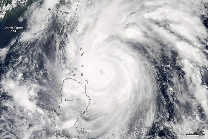
© Earth Observatory, NASANASA Earth Observatory image created by Jesse Allen, using data obtained from the Land Atmosphere Near real time Capability for EOS (LANCE) archive. Acquired May 27, 2011.
Super Typhoon Songda swirled off the coast of Luzon, at the northern end of the Philippine Islands, on the afternoon of May 27, 2011. Peak winds were around 240 kilometers (150 miles) per hour at 06:00 Universal Time (2 p.m. local time), according to the Joint Typhoon Warning Center (JTWC).

This photo-like image shows Songda roughly an hour prior to the JTWC wind speed measurement. The data were collected by the Moderate Resolution Imaging Spectroradiometer (MODIS) on NASA's Aqua satellite at 1:10 p.m. local time (5:10 UTC) on May 27. The distinct, but cloud-filled eye of the super typhoon was well offshore from the major islands of Luzon and Taiwan, though spiral arms of the storm extended for hundreds of kilometers from the center, bringing severe weather to both places.

The storm's track was predicted to keep it offshore from Taiwan, curving eastward as it travels north. While the storm is quite intense, the fact it has stayed far offshore has kept casualties and damage light. One death in the Philippines had been ascribed to the storm, according to the Philippines disaster council. There has been some crop damage, but since the storm buffeted the islands past the date of harvest, agricultural yields have not been affected.

Cloud Lightning

US: Severe Storms Wreak Havoc from Vermont to Georgia

US weather system
© n/a
Violent weather swept across the Eastern seaboard overnight, dropping heavy rains that flooded towns from New England to Georgia, knocking out power and killing at least three people in the Atlanta area.

Intense thunderstorms stalled over central Vermont, pushing rivers over their banks and ripping up streets. About 200 people were forced from their homes.

Churning brown water from the rising Winooski River and a tributary flooded into the streets of Vermont's capital city, Montpelier, sending business owners with inundated basements scurrying to move merchandise to higher ground.

"It looked like the river was right there on my porch," said Darlene Colby, 47, who was woken up by police around 1 a.m. She gathered a bag for belongings for herself and 25-year-old son and spent the rest of the night at a shelter.

Cloud Lightning

US: Second wind: Tornado near Cressona is 2nd in Schuylkill County in 3 days

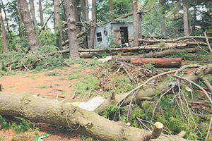
Cressona, Pennsylvania - For the second time this week, a tornado touched down in Schuylkill County.
cressona tornado1
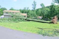
© Nick Meyer/Republican HeraldA tree lies across the front lawn of the property at 1035 Woodland Drive, North Manheim Township, on Friday after a tornado tore through the area Thursday night.
Just three days after the "Lewistown Valley Tornado," a 95-mph EF-1, zoomed through Walker Township on Monday, the "Schuylkill Haven Tornado," a 110-mph EF-1, uprooted trees, knocked down power lines and damaged more than 20 homes along an 18-mile strip from Cressona to West Penn Township, according to the National Weather Service.

"Damage was pretty extensive. Four of those homes had major damage. There were a dozen barns and outbuildings that were also damaged," Greg DeVoir, a meteorologist with the NWS, State College, said Friday evening.

The tornado touched down in North Manheim Township, a half-mile west of Cressona, at 8:15 p.m. Thursday. It bobbed up and touched down numerous times as it continued east, DeVoir said. The tornado was 200 yards wide at its greatest width and its path ended at Leibeyville in West Penn Township at 8:35 p.m.
Cloud Lightning

US: Frankin County, Pennsylvania cleans up; F-1 tornado confirmed

franklin tornado f1
© Public Opinion/Markell DeLoatchTornado damage: Debris and uprooted trees litter a yard on Wayne Road in New Franklin. An F-1 tornado was confirmed for that area.
Winds accompanying a tornado knocked down trees in a path from Marion to Fayetteville.

A tornado with maximum winds of 90 mph touched down briefly in New Franklin and caused little damage compared to widespread down bursts of wind.

The National Weather Service in State College confirmed that a tornado around 6:10 p.m. damaged a pine grove just east of Wayne Road (Pa. 316) in Guilford Township. The EF-1 tornado packed winds of 90 mph and barely missed Dwaine Martin's home and garage, and knocked down a dozen white pines behind his house.

The tornado cut a path 25 yards wide and 200 yards long, according to meteorological technician Tony Mach. The damage area was at the southern end of down burst wind damage that went from just west of Marion eastward through Brownsville, (southeast of Fayetteville).

Martin said the tornado apparently touched down on his driveway and hopped over the garage and came down in the woods. Two small outbuildings were damaged.

The tornado is the seventh confirmed tornado to hit Franklin County since 1974, according to the county Department of Emergency Services.

Cloud Lightning

US: Three Dead in Atlanta After Latest Storms


Three people died in the Atlanta area after straight-line winds gusted to 80 miles per hour on Thursday, ripping across parts of the South in the latest round of violent weather to tear through the U.S.

Nineteen-year-old Alonzo Daniel of Mableton was cleaning debris in his driveway on Stroud Drive when a tree fell on top of him, according to his family.

"As he was running, the tree caught him," Daniel's grandfather Robert Johnson told ABC News affiliate WSBTV in Atlanta.

Additionally, two women were crushed by a falling tree in the Buckhead section of Atlanta. The women were in a Mazda Miata convertible in the early evening when they driver lost control and crashed into a mailbox, firefighters told WSBTV.

Thursday saw more than 600 reports of severe weather across the country, including five tornadoes that stretched from the Gulf to Canada and as far east as Vermont. In New Orleans, four people were injured by the high winds.

Golf ball to baseball-size hail was reported in West Virginia, Maryland, Tennessee, Vermont and in western New York State, but resulted in only minor damage.

Cloud Lightning

US: Oklahoma Tornadoes: Death Toll from Tornadoes Rises to 10

Oklahoma tornadoes: A teenage girl and her boyfriend were among the deceased, along with a 3-year-old Piedmont boy whose body was found Thursday morning.


A teenager who loved the rodeo, two children ripped from their mother's arms and a woman intent on saving her dogs were among those killed in the deadliest Oklahoma tornado outbreak in more than a decade.

Two days after the tornadoes left a path of destruction from Chickasha to Stillwater, authorities on Thursday recovered the body of a 3-year-old boy lost in a twister and finished identifying all 10 known victims.

The tornadoes left at least 238 people injured. Typical sheltering places, bathrooms and closets, could not withstand some of these killing winds. Initial reports indicate more than 600 homes and businesses were damaged, according to the Oklahoma Department of Emergency Management. The National Weather Service said that in terms of loss of life in Oklahoma, this was the worst tornado outbreak since May 3-4, 1999, when 44 people died in the state.

Cloud Lightning

US: The Weather Phenomena Causing 2011's Tornado Explosion

Meteorologist Jeff Masters says that while it might not be climate change, the tornadoes are just one of many weird weather phenomena this year that may be signaling major shifts in the climate.
Image
© NOAA
From April 25 to 28, 2011, a fierce and deadly storm system produced a total of 327 confirmed tornadoes in 21 states from Texas to New York, and even isolated tornadoes in Canada. Alabama was struck particularly hard. These April 2011 tornadoes killed at least 344 people people in the Southeast, Midwest, and Northeast. Then--on May 22, 2011--the deadliest single tornado since 1953 struck Joplin, Missouri, with at least 124 people now confirmed dead and more than 1,000 people reportedly injured. Shortly before the tornado struck Joplin, EarthSky spoke to meteorologist Jeff Masters of Weather Underground. He explained some of the science that has caused these fierce 2011 tornadoes in the U.S.

In particular, he said, the location and strength of the jet stream played a role.

"The jet stream, which is that powerful river of air aloft over the country, turned out to be very strong this year. It had very high wind speeds in it. And it was moving over tornado alley, where we tend to get cold, dry air from Canada colliding with warm, moist air from the Gulf of Mexico. The combination of those contrasting air masses, and then the very powerful jet stream, was just the perfect storm of conditions to make a lot of tornadoes."

Bizarro Earth

NASA sees a 14-mile-wide eye and powerful Super Typhoon Songda

Typhoon Songda became a Super Typhoon in the evening on May 26, 2011 (Eastern Daylight Time) was it reached a Category 5 status on the Saffir-Simpson Scale. NASA satellite data shows that the monster storm with a 14 mile-wide eye has weakened due to adverse wind conditions today and is still a powerful Category 4 typhoon.

Image
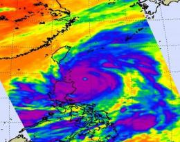
© NASA/JPL, Ed OlsenThis infrared image of Super Typhoon Songda was captured by the AIRS instrument on NASA's Aqua satellite on May 27, 2011, at 5:05 UTC (1:05 a.m. EDT). At this time, Songda was a Category 4 storm. The purple areas indicate very strong thunderstorms with heavy rainfall and there is a large area of them that surround the visible eye. Taiwan is northwest of the storm.
The Atmospheric Infrared Sounder (AIRS) instrument on NASA's Aqua satellite captured an infrared image of Super Typhoon Songda on May 27, 2011 at 5:05 UTC (1:05 a.m. EDT). At that time Songda was a Category 4 storm. The infrared image showed a large area of very strong thunderstorms with heavy rainfall surrounding the eye of the storm. The eye is almost 14 miles (12 nm/22 km) in diameter and those thunderstorms were dropping rainfall as much as 2 inches (50 mm) per hour.

On May 27 at 1500 UTC (11 a.m. EDT), Typhoon Songda's maximum sustained winds were near 125 knots (143 mph/231 kmh) down from its peak of 140 knots (161 mph/260 kmh) which it reached late on May 26. Sondga has tracked north-northwest but is expected to turn to the north-northeast.