Storms
S

Cloud Lightning

US: Massive Mile Wide Tornado Tuscaloosa, Alabama 4-27-11

tuscaloosa tornado
© Don Kausler Jr./Tuscaloosa BureauThe enormous tornado that hit Tuscaloosa Wednesday afternoon.
A massive tornado judged to be almost a mile wide struck Tuscaloosa late Wednesday afternoon. ABC 33/40 meteorologist James Spann says the storm has caused "major, major damage" in some areas of the city and Mayor Walt Maddox told The Weather Channel that parts of the city were "obliterated."

A Tuscaloosa resident going by Clay Hasenfuss on Twitter posted this dramatic video of the tornado dwarfing Bryant-Denny Stadium.

"I'm in my car at corner on McFarland. Milo's Hamburgers isn't there anymore," said Tuscaloosa resident Phil Owen. "Hobby Lobby only thing still standing at Woods Square Shopping Center. Big Lots, Full Moon Barbecue. Piles of garbage where those places were. Shell gas station across the street, all that's standing is the frame of the store."

Cloud Lightning

US: Mile Wide Wedge Tornado Going Through Downtown Birmingham Alabama

Spotters reporting EF4-EF5 type damage, so you may be looking at entire neighborhoods completely destroyed and some lives lost. If people took their precautions, they should survive but will have injuries. A tornado of this size and strength will destroy everything in its path.


Cloud Lightning

US: More severe storms to hit North Georgia Wednesday night

storm damage
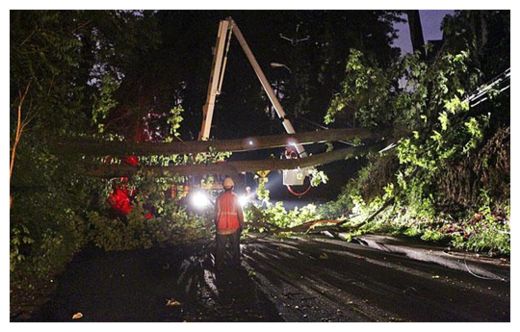
© John Spink, jspink@ajc.comPower crews were out dealing with numerous outages caused by downed trees and power lines like this one at Marietta Road and Spring Avenue in Atlanta that hampered truck traffic trying to make deliveries to nearby businesses.
A new round of severe weather is expected to hit north Georgia Wednesday night after storms left a trail of widespread damage in northwest Georgia and killed five people in Alabama.

The National Weather Service says the next storm system should begin to approach the northwest Georgia border around 6 p.m.

Extensive wind damage was reported in Floyd, Gordon, Haralson and Dade counties, including damage on the campuses of Berry College and Shorter University near Rome.

No Entry

US: Rain-swollen rivers threaten Midwest, force evacuation in Missouri town

Image
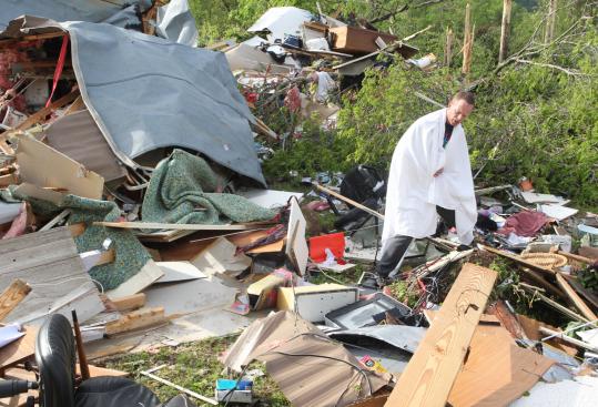
© Richard Rasmussen/The Sentinel-Record/Associated PressA resident of Garland County, Ark., looked for his cellphone yesterday in the remains of his home after a tornado hit the area.
A powerful storm system that spawned a deadly tornado in Arkansas caused rivers to swell yesterday across the Midwest, straining levees that protect thousands of homes and forcing panicked residents of one town to flee for higher ground.

Six inches of rain fell Monday in the southeastern Missouri community of Poplar Bluff, bringing the four-day total to 15 inches. The deluge caused the Black River to pour over a levee in 30 places and to break through in one spot, and about 1,000 homes were evacuated. Deputy Police Chief Jeff Rolland said it was a "miracle'' that the levee held until late morning.

The levee extends from Poplar Bluff to the town of Qulan downstream, in a sparsely populated area. Butler County Sheriff Mark Dodd said water pouring through a breach between the two towns was unlikely to make it far enough upstream to threaten Poplar Bluff, a town of 17,000 residents south of St. Louis.

Flooding in 2008 damaged or destroyed hundreds of homes in Poplar Bluff, raising questions about whether the levee was capable of protecting the town during times of heavy rainfall.
Cloud Lightning

US: 2 Dead in Arkansas, Missouri. Residents Flee Flooding

Tornado Dallas
© ABC NewsDark storm and funnel clouds form over Dallas, Texas on April 25, 2011
At least two people have been killed in Arkansas during the recent round of heavy storms and tornadoes that ripped through the midwest while Missouri residents flee from flooding, authorities said.

Arkansas authorities told the Associated Press the two people were killed following the severe storms that passed through the state.

In Missouri's Poplar Bluff, residents evacuated amid fears of the flooding, the Associated Press reported.

Water began to leak and overflow the levee holding back the Black River, officials said.

Tornadoes were forming over Dallas late Monday afternoon, as the weather there turned ominous, threatened by a storm system that has brought 200 reports of severe weather across the country over the last 24 hours.

Cloud Lightning

U.S.: Extremely Dangerous Tornado Situation Today

An extremely dangerous outbreak of tornadoes will endanger many lives and property from northeastern Texas into Arkansas, northern Louisiana, northwestern Mississippi and western Tennessee this afternoon into tonight.

Image
These are the same areas that were just hit by tornadoes Monday afternoon and night, and today's outbreak is expected to be worse than Monday's. Large, long-track tornadoes are a major concern through tonight.

"It's a very dangerous day," said AccuWeather.com Senior Meteorologist Henry Margusity. "It's the kind of day where tornadoes could cause massive destruction."

The Little Rock, Ark., area is at risk again after multiple tornadoes, including one large twister, just tore through Monday night.

Thunderstorms were starting to initiate over northeastern Texas and southwestern Arkansas around mid-afternoon and will continue developing and becoming more widespread and powerful into this evening.

The thunderstorms and tornado danger will reach the western Tennessee Valley by tonight, before shifting farther east through the Tennessee and Ohio Valleys Wednesday into Wednesday night.

Attention

'The town's gone': Seven dead as storm slams Arkansas

50 to 60 still unaccounted for in Vilonia; trail of destruction 15 miles long, three miles wide


The National Weather Service says first light has revealed the track of a deadly tornado that flattened trees and power lines, tore the roofs from homes and left a debris-strewn path through a small central Arkansas town.

The tornado that swiped Vilonia late Monday killed at least four residents, while the severe storms sweeping much of the Midwest left at least three people dead elsewhere in the state.

Emergency crews are preparing to search for dozens of people still missing early Tuesday before more forecast storms strike the area in the afternoon.

Arkansas Gov. Mike Beebe declared a state of emergency Monday night. So far this month, 14 people have died in storm-related incidents in the state.

Get the latest on this story, including user photos, on breakingnews.com

The suspected tornado that hit Vilonia left a path of damage three miles wide and 15 miles long, officials said. Between 50 to 80 houses were destroyed, according to Faulkner County emergency management.

Cloud Lightning

Ohio, US: More rain expected as region surpasses April record

Mostly cloudy with showers and thunderstorms likely throughout much of the day.

Sound familiar?

Once again, local residents experienced more rain Monday, adding to the April record of 11.32 inches set over the weekend, according to the National Weather Service.

The previous April record of 9.77 inches was set in 1998, and there are still five days remaining this month.

So far, this month has been the fifth-wettest in history and the area could break the all-time record of 13.86 set in January 1937, according to meteorologist Julie Reed.

Totals could approach 14 inches, Reed said, as heavy rains Tuesday night into Wednesday move in.

"It could be pretty volatile throughout the area into Wednesday evening," Reed said.

Cloud Lightning

Brazil: Dozen die in floods and landslides

Image
© Unknown
Landslides and floods in southern Brazil over the weekend are now known to have left a dozen people dead.

Some 40,000 people have been affected by the torrential rain and several hundred left homeless.

The authorities in the state of Rio Grande do Sul have declared a state of emergency in seven cities.

Among the dead were seven family members whose homes in the town of Igrejinha were buried by a landslide.

Cloud Lightning

Indiana, US: Storms continue; floods forecast

The National Weather Service in northern Indiana has issued a number of flood watches and warnings for northeast Indiana and northwest Ohio.

The flood warning continues for the following rivers:
  • St. Joseph River affecting Allen and DeKalb counties in Indiana and Defiance County in Ohio until Friday night. At 1 p.m. Monday, the river was 9.8 feet and falling in Fort Wayne. Flood stage is 12.0 feet, and the weather service said it is likely to rise above flood stage Tuesday morning and crest near 14.9 feet by 2 a.m. Wednesday. Minor flooding is forecast.
  • St. Joseph River near Newville was measured at 12.5 feet and steady at 3 p.m. Monday, with minor flooding. Flood stage is 12.0 feet. The river is expected to crest near 134.0 feet about 2 p.m. Thursday. Moderate flooding is forecast.
  • Wabash River near Bluffton affecting Huntington and Wells counties.
  • Tiffin River near Stryker affecting Defiance, Fulton and Williams counties in Ohio.