Wildfires
S


Phoenix

Flagstaff Fire: Blaze at 200-300 acres; pre-evacuation orders for south Boulder, Colorado


Aided by a massive C-130 air tanker, Boulder County firefighters are battling a 200-to-300-acre wildfire west of Boulder this afternoon, a fast-growing and "extreme" blaze that has forced the evacuation of 26 households in the foothills and put parts of south Boulder on pre-evacuation notice.

Approximately 931 south Boulder phone numbers have been called with pre-evaucation warnings.

"We're about one ridge over from the city of Boulder," Boulder County sheriff's spokesman Rick Brough said of the fire at an afternoon press briefing.

The fire started near the 1500 block of Bison Drive in the Walker Ranch area around 1:15 p.m. and is believed to have been sparked by lightning, Brough said.

The blaze is now burning toward the northeast, Brough said.

Bizarro Earth

Second wildfire rages across Utah: 39,000 acres goes up in flames

Image
© Unknown
All Robin Coltharp can do is wait and watch.

"We don't even know if our property is still good or not, if it's burned," she said.

Coltharp's husband used a telescope to get a closer look at the property, which Sunday was about a mile away from area burned in the Wood Hollow Fire.

The wildfire continued to rage Sunday, covering more than 39,000 acres in Sanpete County, destroying between 25 and 30 structures and forcing evacuations of more than 200 homes. At last word, only the fire was only 4 percent contained.

Roughly 360 permanent structures and more than 200 trailers or sheds are threatened, the Summit County Sheriff's Office said.

The Coltharps live in Mt. Pleasant and own 5 acres of land on Baldy Mountain. On Sunday, they couldn't see the mountain through the thick smoke.

"We had plans of building a cabin up there," she said, "perhaps living up there."
Phoenix

Treasure Fire Burning 20 Acres Near Leadville, Colorado

leadville fire
© Junko Kazukawa
A ninth wildfire began burning near Leadville on Saturday afternoon.

The Treasure Fire has burned 20 acres near Fremont Pass, between Leadville and Copper Mountain Resort.

According to Keith McMillan of Red, White and Blue Fire Department, the wildfire is burning in forest land on the west side of State Highway 91.

Phoenix

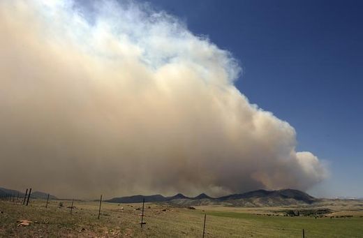
Colorado's High Park fire at 82,190 acres; new pre-evacuation orders

The High Park fire in Colorado
© Hyoung Chang, The Denver PostThe High Park fire in Colorado burns west of Fort Collins, as seen from Highway 287 in Larimer County on Saturday.
The High Park fire has now surpassed the Missionary Ridge fire as the second largest in state history at 75,537 acres.

High Park fire officials have sent 235 pre-evacuation notices to Bonner Peak Subdivision, including Springs Ranch Road.

Issued at midnight, the pre-evacuation is also for County Road 74E, also known as Red Feather Lakes Road, from the junction of U.S. 287, west to include County Road 37, north to include County Road 76H, east to U.S. 287 and south to County Road 74E.

All residents need to be prepared to evacuate at a moment's notice, according to the Larimer County Sheriff's Office.

Other evacuation orders had been sent out to 998 homes late Friday after a spot fire ignited by wind-blown embersfrom the main blaze erupted north of Poudre Canyon.

Phoenix

16 Homes Lost As Estes Park Fire Spreads


Blaze Closes South Entrance To Rocky Mountain National Park


Colorado -- A house fire spread to 15 additional homes in Estes Park around noon on Saturday.The fire, in a cabin on High Drive also spread to nearby wildland, sending a thick plume of black smoke into the sky over Estes Park.The Woodland Heights Fire was reported just after noon and was burning near the south entrance to Rocky Mountain National Park. It was estimated at 20 acres in size at 2:30 p.m.

Bizarro Earth

Russia declares state of emergency as hundreds of wildfires race across northern interior

Image
© Katrina Jackson, NASA's Goddard Space Flight Center
Russia has declared a state of emergency in several eastern regions due to hundreds of wildfires. NASA's Terra satellite captured this image of fires and smoke in north central Russia on June 15, 2012, at 05:50 UTC (1:50 a.m. EDT) The red spots are where the Moderate Resolution Imaging Spectroradiometer (MODIS) instrument that flies aboard the Terra satellite detected heat signatures. Dry conditions, agricultural burning, lightning and human involvement have contributed to many wildfires across Siberia over the last few weeks.

Click here for larger image.

To learn about smoke from Siberian fires crossing the Pacific Ocean, visit here.

Phoenix

Deadly Colorado wildfire surpasses 100-square-mile mark

plane
© Reuters/Rick Wilking
A deadly, stubborn wildfire that ranks as the most destructive on record for Colorado has scorched more than 100 square miles (259 square km) of rugged mountain terrain northwest of Denver, but a cool snap on Wednesday gave fire crews a chance to take the offensive.

The so-called High Park Fire already is blamed for one death and has consumed 189 homes in the 12 days since it was ignited by lightning at the edge of the Roosevelt National Forest, and authorities say they expect property losses to climb once more damage assessments are made.

As of Wednesday, an estimated 1,000 homes remained evacuated on the western outskirts of Fort Collins, a city of more 140,000 people that lies adjacent to the national forest about 55 miles north of Denver, according to Larimer County Sheriff's spokesman John Schulz.

The only casualty reported from the fire so far was a 62-year-old grandmother whose body was found last week in the ashes of a cabin where she lived alone. She was the fourth person to die in a Colorado wildfire this year.

Hardhat

Wildfires Rage in Siberia: State of Emergency Declared


A state of emergency has been declared in several eastern regions, where hundreds of wildfires are now raging.

­The wildfires cover an 8,331-hectare area in total, according to the Siberian Federal District Forestry Department. Around 1,600 people and 42 planes are now fighting the fires.

According to Greenpeace, the situation is worse now than at the same time in the summer of 2010, when Russia was devastated by forest fires.

Local authorities, however, claim there is currently no threat to local populated areas or businesses. The fires have decreased by one-third over the weekend.

Phoenix

Colorado wildfire: High Park Fire claims 181 homes

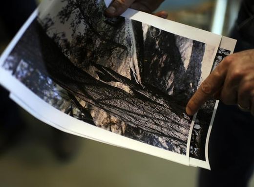
Gov. John Hickenlooper shows a photo of the tree hit by lightning that started the High Park Fire.
© The Denver Post | Hyoung ChangGov. John Hickenlooper shows a photo of the tree hit by lightning that started the High Park Fire.
Larimer County Sheriff's officials said this afternoon that the number of homes lost in the High Park fire has reached 181, the most in Colorado history surpassing the Four Mile fire in 2010, which claimed 169 homes.

Meantime, the evacuation order for residents of the Santanka Trail area on the north end of Horsetooth Reservoir has been lifted. Residents in the neighborhoods of Soldier Canyon and Mill Canyon also will be able to return home starting at 6 tonight. This area will only be open to residents for the time being to give them time to move back in and for officials to secure the area.

Fire officials said the main priority for fire crews today remains structure protection and keeping the edge of the fire south of Poudre Canyon and north of Buckhorn Road in check.

Phoenix

High Park Fire: Number of homes destroyed by 52,000-acre wildfire soars to 112

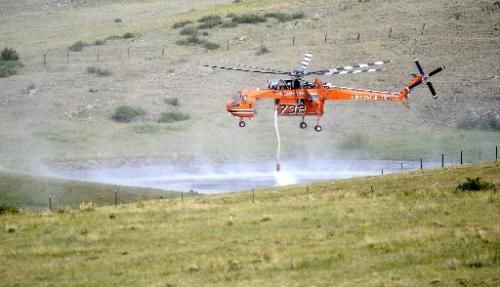
Sky Crane lifts
© Mark LeffingwellA Sky Crane lifts up after filling its water tank in a small pond to help with fire suppression in the High Park Fire near Livermore, Colorado, on Friday, June 16, 2012.
Bellvue, Colorado -- The number of homes destroyed in the giant High Park Fire west of Fort Collins jumped to 112 on Friday after fire officials were able to get a better assessment of the damage wrought by the nearly week-long blaze.

The largest number of homes lost -- 40 in all -- were in the Whale Rock area, according to Larimer County sheriff's spokesman Nick Christensen. Another 21 homes were destroyed in the Stratton Park area.

"That number will continue to grow," Christensen said.

An updated list of burned homes likely will be released Saturday after families are notified, he said. Areas currently being assessed for damage are Redstone, Buckhorn Road and Lawrence Creek, Christensen said.

This morning's official tally of burned homes was 48. The High Park Fire's containment figure of 15 percent and size of 52,000 acres didn't change at Friday afternoon's briefing.