Volcanoes
S


Attention

Mysterious noises emanating from volcano in Iceland

Image
Strange rumblings coming from the tuya Herðubreið are confounding observers as to their possible source.

Vísir reports that visitors to the mesa-shaped volcano in northeast Iceland have been unable to determine if the persistent rumblings coming from Herðubreið are being caused by an avalanche, landslide, or something else entirely. Rangers around Herðubreið were the first to announce the rumblings, which lasted about 30 seconds.

Yesterday, Icelandic rescuers who had been searching for a group of French tourists found them at the foot of Herðubreið safe and sound, although they said there had been an avalanche. News of the avalanche was reported, but upon further inspection, no evidence of an avalanche could be found - except for the rumbling.

Avalanches have been reported from mountains all over Iceland recently, which is highly unusual for the summer months. Tómas Jóhannesson, a meteorologist at the Met Office, told reporters that they intend to get to the bottom of the mystery.

Bizarro Earth

Japanese volcano Kuchinoerabu-Jima erupts for first time in 34 years

kuchinoerabu-Jima volcano
A new eruption occurred yesterday at the volcano at 12h25 local time. It consisted of a single powerful explosion from the Shin-Dake crater. An ash plume rose to approx 1.5 km height, and a pyroclastic flow was generated. The eruption lasted about 10 minutes and much of the erupted mass collapsed into an impressive pyroclastic flow (hot avalanche of fragmented lava and gasses). There are no reports of victims or damage. Japanese volcanologists raised the alert level to 3 and closed access to the summit area.

Bizarro Earth

Scientist map Mount Rainer magma, say it will erupt again

mount rainier magma map
Scientists from the University of Utah have determined that Mount Rainier, one of the most prominent peaks in North America, will erupt again. The question of when remains unanswered, but science has recently discovered how: By measuring how quickly Earth conducts electricity and seismic waves, they've effectively "mapped" Rainier's magma "plumbing."

"This is the most direct image yet capturing the melting process that feeds magma into a crustal reservoir that eventually is tapped for eruptions," says geophysicist Phil Wannamaker, of the university's Energy & Geoscience Institute and Department of Civil and Environmental Engineering. "But it does not provide any information on the timing of future eruptions from Mount Rainier or other Cascade Range volcanoes."

Comment: For more information see:

Rainier, third most dangerous U.S. volcano, USGS says
Mapping the deep magma reservoir below Washington's Mt. Rainier


Bizarro Earth

Mapping the deep magma reservoir below Washington's Mt. Rainier

Image
© R. Shane McGary / Woods Hole Oceanographic InstitutionMap shows, in purple and pink, the west-east line of magnetotelluric sensors that were placed north of Mount Rainier.
Experts have mapped a huge magma reservoir below Mount Rainier in Washington state that begins melting deep in the Earth's mantle before pushing upwards to where it will eventually be tapped for eruption. Researchers from the United States and Norway used seismic imaging and the measurement of variations in electrical and magnetic fields to create a detailed road map of the pathway molten rock takes to the surface.

Their findings, published this week in the journal Nature, are aimed at helping experts understand the volcano's inner workings, and eventually determine when it might again erupt. A state landmark, Mount Rainier last erupted in the 19th century. It is widely expected to erupt again, according to the U.S. National Park Service.

The tallest volcano and fifth-highest peak in the contiguous United States, it towers some 14,410-feet (4,392 meters) about 58 miles (93 km) southeast of Seattle, from most of which it is visible.

Comment: No such thing as a dormant volcano: Magma chambers awake sooner than thought


Alarm Clock

Volcanic earthquakes detected at Philippine's Bulusan volcano

Image
© USGS/Chris Newhall
Although not posing any serious threats at the moment, the Philippine Institute of Volcanology and Seismology (Phivolcs) on Sunday told the public to stay away from Bulusan volcano's permanent danger zone in Sorsogon after volcanic earthquakes were detected.

"During the 24-hour observation period, the seismic network detected thirteen (13) volcanic earthquakes. Ground deformation data from continuous GPS and precise leveling survey also indicated that the volcano is slightly inflated," Phivolcs said in a statement.

The agency said the volcano's status is still at alert level 0.

"The local government units and the public are reminded that entry to the four-kilometer radius Permanent Danger Zone (PDZ) is strictly prohibited due to the possibility of sudden and hazardous steam-driven or phreatic eruptions," Phivolcs said.

It warned against aircraft flying near the volcano's summit since sudden eruption may be harmful.

Attention

Mount Sinabung volcano erupts (again) in Indonesia

Image
© Baltimore Sun/Matt Bracken
Mount Sinabung, one of the most active volcanoes in Indonesia, has erupted, spewing ash to the sky. No casualty was reported, official said here Sunday.

The volcano located in Karo district of North Sumatra province erupted at 23.05 p.m. Saturday, Sutopo Purwo Nugroho, spokesman of national disaster management agency, said.

"The height of the eruption could not be determined as it took place at night and there were many clouds," he told Xinhua by phone.

"Rains of hot ash occurred in several place in Karo district, but it did not trigger further evacuation," Sutopo added.

The 2,600-metre (8,530-foot) Mount Sinabung last erupted June 29, shooting columns of ash by up to 4,000 metres into the sky.


Bizarro Earth

El Salvador's Chaparrastique volcano continues to show significant levels of internal seismic activity

The Chaparrastique volcano near San Miguel, El Salvador continues to show significant levels of internal seismic activity. Authorities are on a high level of preparedness should actions be needed. The activity since yesterday has been at the highest levels seen. The chart below shows activity during July -- the average, normal level is 50, and current levels are above 1100.
Image
This graphic shows the location of micro-quakes on the northern slopes of the volcano:
Image

Bizarro Earth

Costa Rica's 'extinct' Chata volcano being re-examined for activity

Image
Volcanologists of the National Seismological Network (RSN) have begun early research on the Chato volcano, located southeast of Poas volcano, to find out information such as its last eruption. RSN volcanologist, Gino Gonzalez, said that measurements of the temperature of the lagoon taken by sonar instrumentation, determining that the surface of the lake is about 19°C and approximately 6 meters deeper the temperature of the lagoon varies drastically.

"It's a volcano which very little is known about its historical activity, so we have seismic stations for periodic sampling and we are starting a campaign to closely monitor it every six months," Gonzalez said. Chato is considered an extinct volcano according to the authorities who made the first sampling to verify the behavior and activity.

According to volcanologist at greater depths there is an increase in the amount of dissolved oxygen in the lake, which could be due to a strong photosynthetic activity, consistent with high turbidity or gas accumulation at deeper levels. The maximum depth of the lake is around 18 meters, averaging 15 meters.

Phoenix

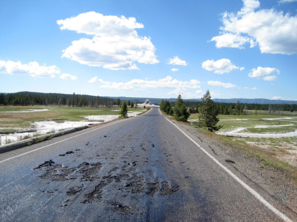
Hot spot: Yellowstone road melts, sites closed

Yellowstone
© National park ServiceFirehole Lake Drive superheated by surrounding thermals
The ever-changing thermal geology of Yellowstone National Park has created a hot spot that melted an asphalt road and closed access to popular geysers and other attractions at the height of tourist season, officials said Thursday.

As they examined possible fixes, park officials warned visitors not to hike into the affected area, where the danger of stepping through solid-looking soil into boiling-hot water was high.

"There are plenty of other great places to see thermal features in the park," Yellowstone spokesman Al Nash said. "I wouldn't risk personal injury to see these during this temporary closure."

Naturally changing thermal features often damage Yellowstone's roads and boardwalks. Steaming potholes in asphalt roads and parking lots - marked off by traffic cones - are fairly common curiosities.

However, the damage to Firehole Lake Drive is unusually severe and could take several days to fix. The 3.3-mile loop six miles north of Old Faithful takes visitors past Great Fountain Geyser, White Dome Geyser and Firehole Lake.

Unusually warm weather for Yellowstone - with high temperatures in the mid-80s - has contributed to turning the road into a hot, sticky mess.

"We've got some ideas. We're going to try them. Our maintenance staff has really looked at the issue," Nash said.

Sherlock

Deep in the Antarctic ice, the history of planet's biggest volcanic explosions

Image
© Independent
Scientists have been able to trace the history of volcanic eruptions over the last 2,000 years by analysing deposits of sulphate dust in a series of ice cores drilled deep into the West Antarctic ice sheet

Some of the biggest volcanic eruptions of the last 2,000 years have left their indelible mark deep within the pristine ice sheet of the Antarctic, a study has found.

Scientists have been able to trace the most complete history of volcanic eruptions since the birth of Christ by analysing deposits of sulphate dust in a series of ice cores drilled deep into the West Antarctic ice sheet.

The time series from 26 separate ice cores drilled out from 19 different sites shows that there were 116 volcanic eruptions in the past two millennia that were big enough to result in plumes of volcanic sulphate dust being transported as far as the South Pole.

Most the eruptions cannot be identified, however the biggest, in 1257, was already hinted at from medieval chronicles and tree rings. Scientists identified the sulphate deposits as coming from the Samalas volcano on Lombok Island of Indonesia.