Volcanoes
S


Bizarro Earth

There's a New Volcano to Worry About, and This Time It's in the USA - Mount Cleveland

Image
© WikiMediaMount Cleveland
As you know we're still in the first week of the new year, but there's already a brand new volcano - complete with ash-cloud potential - getting ready to wreak havoc on air travel. Unlike the volcanoes over in Europe or down in South America, this one's a little closer to home, and it's a heck of a lot easier to pronounce.

Mount Cleveland - just rolls off the tongue - is located within the Aleutian Islands off the coast of Alaska, and scientists believe that it's getting ready to celebrate 2012 by starting to shake, rattle, and roll. Just over a week ago there was a little volcano hiccup that sent a whole bunch of ash and other particulate into the skies, but things quickly dissipated and flights weren't really affected. The concern still remains, as the tippy top of the volcano is right in the way of one of the main commercial flight paths between North America and Asia.

Bizarro Earth

Another Icelandic Volcano Is Rumbling - Katla

Katla, yet another huge Icelandic volcano, is showing signs that it may soon erupt and cause chaos to world air transport.

Al Jazeera reports that earth tremors around the immense volcano are leading to concerns that an eruption could have both profound effects on Iceland's landscape, as well as disrupting travel worldwide. The volcano last erupted in 1918, making it well overdue for a blast, and it's lava chamber is thought to be some 10 times the size of Eyjafjallajökull, which erupted in 2010.

(By the way, this is hardly the only Icelandic volcano you should be worrying about. Last year we saw reports that Grimsvotn and Bárdarbunga, two other icelandic volcanos, were due to erupt.)


Bizarro Earth

Greece: Increased Seismic Activity at Dangerous Santorini Caldera

Image
© Expolrecrete.comThe eruption of the Santorini Volcano
The seismic unrest beneath Santorini which had started in July 2011 continues into 2012, greeting the world with a small swarm of quakes beneath the caldera.

The slightly increased number of quakes is concentrated on the volcano-tectonic Kameni line, which stretches SW-NE through the caldera and extends outside, especially to the NE where the submarine volcano Kolumbo is located 8 km off the coast. The alignment defines a tectonic graben structure underlying Santorini and has been used for rising magma for nearly all past eruptions of the volcano.

Attention

Indonesia: Recent Earthquakes Rattling East Java Have Agitated Volcanoes

Image
© lombokmarine.comMount Semeru or Gunung Semeru
People living in the vicinity of three volcanoes in East Java have been warned to be on the alert as they were showing signs of increased volcanic activity. The three volcanoes are Mt Ijen, Mt Semeru and Mt Bromo. East Java district disaster management head Timur Siswanto said the authorities were in a state of readiness to handle any volcanic disasters and had established command posts for relief work should any of the volcanoes erupt.

He was reported as saying by the local media that Mt Ijen was showing the most activity and that people living in its vicinity had been warned not to come within a 1.5 kilometer radius of the mountain. Besides the above three, five other volcanoes - Mt Gamalama (Ternate Island, Moluccas), Mt Papandayan (Garut, West Java), Gunung Karangetang (northern Sulawesi ), Gunung Lokon (northern Sulawesi) and Anak Krakatau (Sunda Strait) - were also reported to have started "rumbling."

Alarm Clock

UK: Is a super-volcano just 390 miles from London about to erupt?

Image
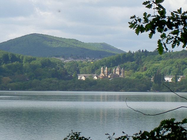
© UnknownHidden menace: Laacher See looks tranquil, but beneath its waters lies a volcano that could devastate Europe.
A sleeping super-volcano in Germany is showing worrying signs of waking up.

It's lurking just 390 miles away underneath the tranquil Laacher See lake near Bonn and is capable of ejecting billions of tons of magma.

This monster erupts every 10 to 12,000 years and last went off 12,900 years ago, so it could blow at any time.

Phoenix

US: Air traffic alert after Alaska volcano spews ash cloud

Cleveland Volcano in the Aleutian Islands
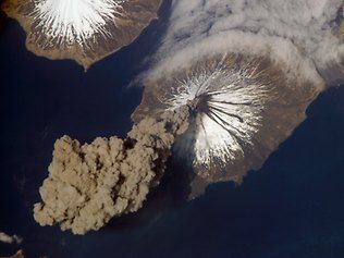
© APThe Cleveland Volcano in the Aleutian Islands in Alaska erupted in 2006 too as this photo shows.

Anchorage, Alaska - A remote volcano in Alaska's Aleutian islands erupted early on Thursday, spouting an ash cloud 15,000 feet into the sky and prompting an air-traffic alert, scientists said.

The Cleveland Volcano, located on an uninhabited island 940 miles southwest of Anchorage, had been oozing lava and gas since July.

Ash from the 5,676-foot volcano is considered potentially dangerous to aircraft because Cleveland's peak lies directly below commercial flight routes between Asia and North America.

Additional explosions producing larger ash clouds are possible and could come without warning, the observatory said.

Phoenix

New island born in Red Sea after volcanic activity

London: A new island is forming in the Red Sea in the Zubair archipelago resulting from a volcanic activity as lava is cooled by the surrounding seawater and solidifies.

The underwater volcano behind the formation is located on the Red Sea Rift, where the African and Arabian tectonic plates are slowly pulling apart," New Scientist reported.

On 19 December, Yemeni fishermen first spotted lava spewing 30 metres into the air, which was later confirmed by satellite observations.

Bizarro Earth

US Alaska: Cleveland Volcano sends ash up to 15,000 feet

A volcano in Alaska's Aleutian Islands sent up an ash cloud today that prompted scientists to increase the alert level for commercial aircraft traffic.

The Alaska Volcano Observatory said satellite images at 4:02 a.m. Alaska time showed Cleveland Volcano had spewed ash 15,000 feet into the air in a cloud that moved east-southeast. U.S. Geological Survey scientist-in-charge John Power called it a small explosion.
Image
© Alaska Volcano ObservatoryA satellite image of Cleveland Volcano on Oct. 7. The summit of the volcano is mostly snow-covered, and the growing lava dome is seen as the dark feature in the center of the volcano (inset area outlined by black square).
"It's not expected to cause a disruption to big international air carriers," he said.

However, it was significant enough to raise the alert level from yellow, representing elevated unrest, to orange, representing an increased potential of eruption, or an eruption under way with minor ash emissions or no emissions.

Info

Supervolcanoes Won't Destroy Earth in 2012

Yellowstone Volcano
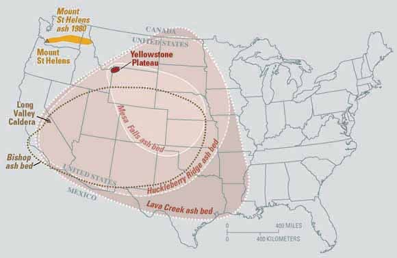
© USGSEruptions of the Yellowstone volcanic system have included the two largest volcanic eruptions in North America in the past few million years; the third largest was at Long Valley in California and produced the Bishop ash bed. The biggest of the Yellowstone eruptions occurred 2.1 million years ago, depositing the Huckleberry Ridge ash bed.
The notion that the world will end with the coming of the new year, as some claim the ancient Maya predicted, has spawned a series of proposed methods for this planetary disaster: galactic forces, Earth's magnetic poles flipping, the eruption of a supervolcano.

Though it has been shown that the Mayans did not in fact predict 2012 would bring the end of the world, there have been supervolcano eruptions in Earth's past that have wrought significant destruction. One such eruption may have been the cause of a major ancient mass extinction event.

But is another supervolcano eruption on the way? At the dawn of the new year, researchers say: Don't hold your breath.

Radar

Red Sea Volcano: New Island Forms Off Yemen Coast After Underwater Eruption

Image
© Getty Images
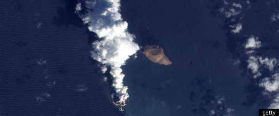
A new island has emerged in the Red Sea following an underwater volcanic eruption.

Fishermen first spotted the phenomenon, which is caused by lava fountains, earlier in December in a remote part of the sea close to the Yemen coast.

The fountains are reported to have reached more than 30 metres (90 feet) in height.

Nasa repositioned their satellite cameras to capture the event, resulting in some amazing shots of the volcanic explosion breaking the water.

Scientists are unsure whether the island will be permanent.

According to a Nasa spokesman the Advanced Land Imager on Nasa's Earth Observing-1 satellite captured the explosion.

"The image from December 2011 shows an apparent island where there had previously been an unbroken water surface," he said.

"A thick plume rises from the island, dark near the bottom and light near the top, perhaps a mixture of volcanic ash and water vapour."

The eruption occurred in a region of the Red Sea where the tectonic plates of Africa and Arabia meet, close to the Zubair Group of islands. Due to constant tectonic shifts, new ocean crust regularly forms along the rift.