Volcanoes
S


Bizarro Earth

Is there deflation and inflation of a large magma body beneath Uturuncu volcano, Bolivia?

Image
© plutons.science.oregonstate.edu Uturuncu volcano
The voluminous ash-flow eruptive products in the Central Andes imply that there are major magma bodies; however, how these magma bodies develop and change in time and space are not understood. In this study, we analyse the deformation activity of the Uturuncu Volcano, SW Bolivia, from 2003 to 2009 using a satellite radar interferometry (InSAR) data set.

We find that the strength and the pattern of the present deformation can be explained by a pressurized source, such as an inflating flat-topped magma body at ∼22 ± 9 km depth below the surface. Furthermore, we examine the optical remote sensing data to perform a lineament analysis, which shows in a geographic information system (GIS) that a girdle of river streams and faults encircle the volcano at radial distance of approximately 15 km.

Alarm Clock

El Salvador evacuates 1000 people near Chaparrastique volcano after seismic activity

Chaparrastique volcano
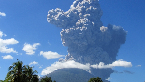
© ReutersOfficials ordered at least 1,000 people to leave the immediate vicinity of the Chaparrastique volcano after seismic activity increased on Monday.
At least 1,000 people living near the Chaparrastique volcano have been evacuated as a precautionary measure after seismic activity increased at the volcano, Salvadoran civil protection authorities said Monday.

There was an explosion early Monday and the volcano then spewed reddish ash, officials said.

The Civil Protection Department said in a statement that an alert had been declared for the municipality of San Miguel, where the volcano is located. The city of San Miguel itself is 50 kilometres from the volcano. It is one of the largest cities in the Central American country.

The 2,129-metre volcano is about 145 kilometres east of San Salvador, the capital of El Salvador.

The volcano's last significant eruption was in 1976.

Bizarro Earth

Scientists say Grenada's Kick'em Jenny underwater volcano poses dangerous tsunami risk to US coast

kick'em jenny volcano
The dangerous Kick’em Jenny volcano has erupted 10 times since 1939, with the most recent eruption in 1990.
A team of scientists from the United States have traveled to Grenada, exploring the darkest corners of a huge underwater volcano off the island's coast hoping to better understanding the mysteries of earthquakes and tsunamis, and ultimately saving lives. President of US Ocean Exploration Trust, Robert Ballard, famous for discovering the Titanic 12,000 feet below the surface of the icy North Atlantic in 1985, has set his sights on exploring the volcano, 'Kick'em Jenny', studying its eruption history and learn more about how underwater volcanoes can pose a threat.

Ballard, who is also director of the Centre for Ocean Exploration at the University of Rhode Island's Graduate School of Oceanography, said the Kick'em Jenny volcano has a history of explosive eruptions, which could have the potential to trigger tsunamis, the effects from which could be felt as far away as the northeastern United States. According to the US Geological Survey (USGS), the Kick'em Jenny volcano has erupted 10 times since 1939, with the most recent eruption in 1990. "This is the most hazardous part of our planet, where (tectonic) plates are head-on," said Ballard, noting that the devastating 2011 Japanese earthquake and the 2004 Indian Ocean earthquake and tsunami were both underwater earthquakes. The American television network, ABC TV, said reporters from its 'Nightline' program accompanied Ballard and his team of 40 explorers aboard their exploration vessel Nautilus during the final 48 hours of their 90-day voyage, which was documented for an upcoming National Geographic special, 'Caribbean's Deadly Underworld', which premieres Sunday on the US network, Nat Geo WILD.

Bizarro Earth

New Hawaiian volcano discovered underwater

Pillow lavas
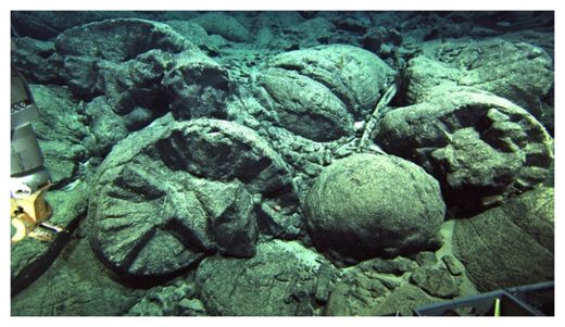
© University of Hawaii at ManoaPillow lavas at Ka'ena volcano, a type of lava that only forms underwater.
The sprawling chain of Hawaiian volcanoes just added another underwater branch.

The discovery means Oahu once towered above the ocean with three volcanic peaks, the researchers said. Until now, scientists thought Oahu was built by two volcanoes - Wai'anae on the west and Ko'olau on the east.

"I think we may very well have had three active volcanoes in the Oahu region," said lead study author John Sinton, a geologist at the University of Hawaii at Manoa.

The new volcano, named Ka'ena, was born in the deep underwater channel south of Kauai about 5 million years ago, according to the study, published May 2 in the Geological Society of America Bulletin. Sometime later, Wai'anae rose on Ka'ena's flanks and therefore breached the sea first, breaking through the waves 3.9 million years ago. The researchers think Ko'olau surfaced after that, about 3 million years ago.

Ka'ena volcano is about 2.5 miles (4 kilometers) high, but only reached about 3,000 feet above sea level, Sinton said. As Oahu's first-born, Ka'ena is the shortest of the three volcanoes because it had to grow farthest from the seafloor to the ocean surface. But the researchers know Ka'ena was once an island peak, because the underwater mountain is capped by lavas with textures that only form in air. With a remotely operated vehicle, the researchers also spied a sandy beach strewn with shark teeth.

Oahu's volcanoes died out about 2 million years ago, and like all of Hawaii's islands, their massive bulk is slowly sinking, hiding Ka'ena beneath the sea.
Target

Best of the Web: Signs of change: Extreme weather, seismic activity, and meteor fireballs in April and early May 2014

Image
The uptick in earthquake activity continues all along the Ring of Fire. At the center of these changes, the United States dealt with "historic flooding" which was labelled a "one-in-500-year event"!

So much more has taken place over the last month or so than this video shows. Deluges continue to hit heavily populated areas. Be prepared for large-scale disasters in your area. It has and it will continue to worsen, whether we like or not. Stay safe and thanks for watching!


Attention

Shishaldin volcano rumbling to life in Alaska

Shishaldin Volcano
© Dave MinerShishaldin Volcano

Shishaldin Volcano is rumbling to life in the Aleutian Islands.

The Alaska Volcano Observatory detected long tremors and an increase in surface temperatures at Shishaldin earlier Tuesday.

Those could be signs of an eruption, says Robert McGimsey, a geologist at the AVO.

"Typical eruptions of Shishaldin have involved what we call Strombolian eruptions, which are gas-charged emissions," McGimsey said.

Shishaldin, which is located on Unimak Island is unique among volcanoes in Alaska. It doesn't have a lava plug or a dome - just a deep, open vent.

McGimsey says that when Shishaldin erupts, "It's gas bubbles coming up through the throat or the vent of the volcano. And when they pop, it just kind of throws magma up into the air. That's kind of what defines lava fountaining."

Alarm Clock

Sakurajima volcano erupting in Japan sending ash 4.5km high

Sakurajima volcano erupts
© "Vesti.Ru"
The Sakurajima volcano started erupting on the southern Japanese island of Kyushu today. Sakurajima is considered to be one of the most active volcanos in Japan. The national meteorological service of the country reports that the column of ash is rising to the height of over 4,5km.

According to Japanese meteorologists, this eruption has become the most powerful this year. The flow of lava and ash is moving in the direction of Ibusiki City but currently there is no information about any wreckage or casualties.

Sakurajima erupts up to several hundred times a year. Today's eruption is No.126. The volcanic activity usually harms the neighbouring Kagoshima Prefecture where the only Japanese space launch site Uchinoura is located.

Comment: The planet certainly is rocking and reeling at the moment and as can be seen from the chart below, volcanic activity reported from 2009 to the present shows a notable and worrying increase.


Bizarro Earth

Record high levels of seismic activity at undersea volcanoes near Mariana Islands, eruptions imminent

Underwater Volcano
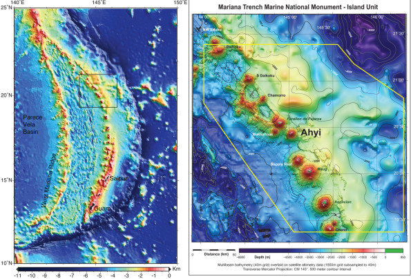
© Susan Merle/NOAABathymetric maps showing the islands and seamounts that make up the Mariana volcanic island arc (left) and the area of Ahyi seamount in the northern part of the arc (right). Susan Merle of NOAA’s Earth-Ocean Interaction Program created these maps.
During the past week, we have been keeping a close watch on the Northern Mariana Islands (NMI), as seismometers on the islands record high levels of seismicity from an undersea volcano near the island of Farallon de Pajaros.

The seismic signals almost certainly herald an eruption. In fact, submarine explosions were heard by scuba divers who are conducting coral reef research in the area. The divers even felt the shock waves from the explosions, and one of the most powerful ones reverberated through the hull of the NOAA base ship, Hi'ialakai, leading the crew to think something had happened to the ship. Shipboard personnel also reported a large sulfur slick on the southeast coastline of Farallon de Pajaros.

Unfortunately, the ship had to leave the area under threat of an advancing typhoon. If they can get back to the vicinity soon, they may be able to investigate the source of the explosions with great caution, keeping in close contact with U.S. Geological Survey (USGS) and CNMI emergency management personnel, who are monitoring the seismicity.

The CNMI emergency management office and the volcano observatories of the USGS have been working together for over 30 years to establish volcano monitoring networks and assess volcanic hazards in the Mariana Islands.

Blue Planet

Heaven and Earth: Earth Changes and Strange Signs in March and April 2014

Image
Here are some of the events I picked up in March and April.

My series include strange phenomena of all kinds and awesome natural events or beautiful phenomena in the previous month or so. I try to make people focus on the important things. Enjoy!

These videos try to make people aware of the powerfulness of the world we are living in. It's but a fraction, and I'm far from covering all events from these past two months.

Do good. Good will return to you. By one way or an other.


This application is not commercial and is free to use.

I don't earn financial benefit from this video and I have the PERSONAL AGREEMENT of EACH artists' work I share in this video.

Igloo

UN issues new 15 year climate tipping point - but UN issued tipping points in 1982 and another 10-year tipping point in 1989!

Image
© Space.com
According to the Boston Globe, the United Nations has issued a new climate "tipping point" by which the world must act to avoid dangerous global warming.

The Boston Globe noted on April 16, 2014: "The world now has a rough deadline for action on climate change. Nations need to take aggressive action in the next 15 years to cut carbon emissions, in order to forestall the worst effects of global warming, says the Intergovernmental Panel on Climate Change."

Once again, the world is being warned of an ecological or climate "tipping point" by the UN.

As early as 1982, the UN was issuing a two decade tipping point. UN official Mostafa Tolba, executive director of the UN Environment Program (UNEP), warned on May 11, 1982, the "world faces an ecological disaster as final as nuclear war within a couple of decades unless governments act now." According to Tolba in 1982, lack of action would bring "by the turn of the century, an environmental catastrophe which will witness devastation as complete, as irreversible as any nuclear holocaust."