Volcanoes
S


Info

New volcano discovered in the Barents Sea

A unique new volcano has been discovered at 400 meters depth in the Barents Sea. The volcano erupts mud, fluids and gas from the planets interior, giving new insight to Earth science.
New Volcano
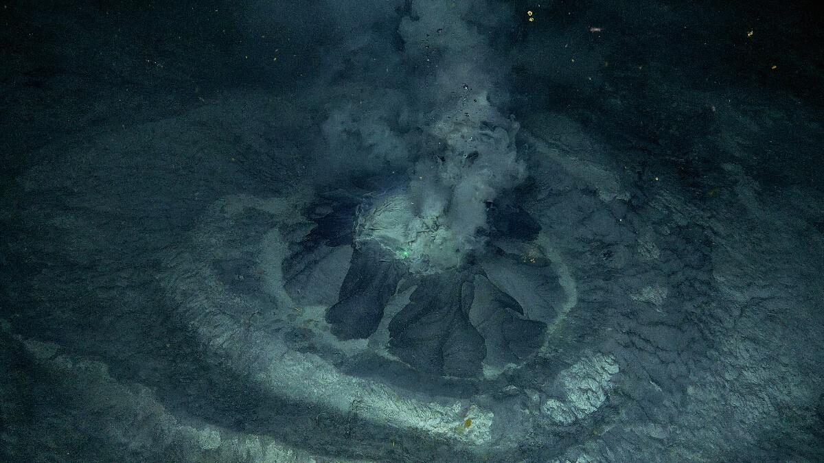
© UIT/AKMA3A new volcano has been discovered by scientists in the Barents Sea. The volcano rests inside a crater which is approximately 300m wide and 25m deep. The Borealis Mud Volcano, which is ca 7 meters in diameter and 2.5 meters high, continuously emits fluids rich in methane.
Scientists from UiT, The Arctic University of Norway, in partnership with REV Ocean, have discovered the second ever mud volcano found within Norwegian waters. This unusual geological phenomenon was discovered onboard the research vessel Kronprins Haakon with the piloted submersible vehicle ROV Aurora in the Southwestern Barents Sea at the outer part of Bjørnøyrenna (Outer Bear Island Trough). It lies at approximately 70 nautical miles south of Bear Island and at 400m depth.

"Seeing an underwater mud eruption in real time reminded me how "alive" our planet is," says Professor Giuliana Panieri, expedition leader and Principal Investigator of the AKMA project.

The volcano has been named The Borealis Mud Volcano.

Fire

Mount Anak Krakatau erupts again

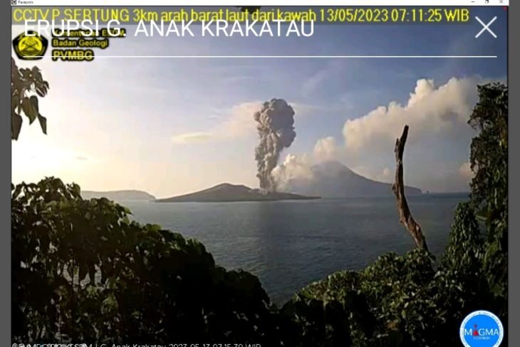
CCTV recorded volcanic ash erupting from Mount Anak Krakata
© PVMBGCCTV recorded volcanic ash erupting from Mount Anak Krakatau in the waters of the Sunda Strait, Lampung Province, experiencing an eruption on Saturday morning (May13, 2023).
Mount Anak Krakatau re-erupted, Saturday, 7:10 a.m. local time, sending ash to about 2,000 meters above the summit or around 2,157 meters above sea level, the Vulcanology and Geological Hazard Mitigation Center (PVMBG) stated.

"The ash column was observed to be gray in color, with a thick intensity, leaning towards the southwest," Head of the Mount Anak Krakatau Monitoring Post Andi Suardi stated in Hargopancuran, Rajabasa Sub-district, South Lampung District, Lampung Province.

According to the PVMBG information broadcast, the volcanic eruption located in the waters of Sunda Strait, Lampung Province, was recorded by a seismograph, with a maximum amplitude of 65 mm and a duration of 68 seconds.


Fire

Popocatépetl volcano (Mexico): eruption showered summit with lava fragments

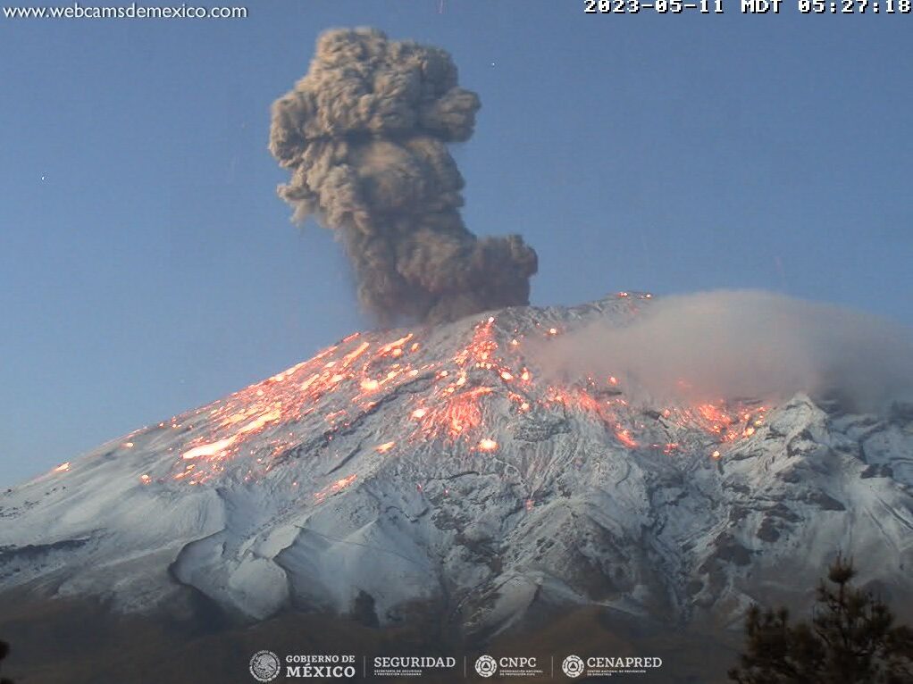
Incandescent bombs, resulting from the eruption, spread over upper snow-covered flanks at Popocatépetl volcano
© CENAPREDIncandescent bombs, resulting from the eruption, spread over upper snow-covered flanks at Popocatépetl volcano
The eruptive activity at the volcano continues at moderately high levels.

The CENAPRED volcano observatory recorded five minor-to-moderate vulcanian-sized eruptions over the past 24 hours, of which one (05:26 local time yesterday) appeared to be powerful.

The explosion ejected hot, glowing lava bombs to approx. height of hundred meters above the summit crater following landing onto the upper snow-capped slopes. The eruption sent an ash column to 23,000 ft (7,000 m) height drifting SE.


Fire

More than 1,000 evacuated as Guatemala volcano erupts

MMMMMMMM
Guatemalan authorities evacuated more than 1,000 people and closed a road as Central America's most active volcano erupted Thursday, spewing thick clouds of ash over farms and towns not far from the capital city.

Civil protection official Oscar Cossio said 1,054 people had been evacuated from five communities near the foot of the volcano and moved to a sports hall for shelter.

He said that number was likely to rise as a full accounting of the evacuees was carried out.

Guatemala's Conred disaster center said the volcano named Fuego, Spanish for "fire," was sending out "pyroclastic flows" -- a high-temperature mix of gas, ash and rock fragments "which descend with great speed down the flanks of the volcanic complex."


Info

Warm liquid spewing from Oregon seafloor comes from Cascadia fault, could offer clues to earthquake hazards

Pythias Oasis
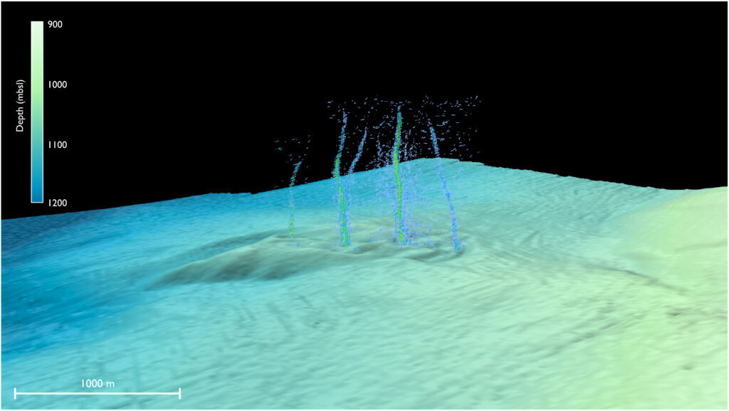
© Philip et al./Science AdvancesThis sonar image of the Pythias Oasis site shows bubbles rising from the seafloor about two-thirds of a mile deep and 50 miles off Newport, Oregon. These bubbles are a byproduct of a unique site where warm, chemically distinct fluid gushes from the seafloor. Researchers believe this fluid comes directly from the Cascadia megathrust zone, or plate boundary, and helps control stress buildup between the two plates.
The field of plate tectonics is not that old, and scientists continue to learn the details of earthquake-producing geologic faults. The Cascadia Subduction Zone — the eerily quiet offshore fault that threatens to unleash a magnitude-9 earthquake in the Pacific Northwest — still holds many mysteries.

A study led by the University of Washington discovered seeps of warm, chemically distinct liquid shooting up from the seafloor about 50 miles off Newport, Oregon. The paper, published Jan. 25 in Science Advances, describes the unique underwater spring the researchers named Pythia's Oasis. Observations suggest the spring is sourced from water 2.5 miles beneath the seafloor at the plate boundary, regulating stress on the offshore fault.

The team made the discovery during a weather-related delay for a cruise aboard the RV Thomas G. Thompson. The ship's sonar showed unexpected plumes of bubbles about three-quarters of a mile beneath the ocean's surface. Further exploration using an underwater robot revealed the bubbles were just a minor component of warm, chemically distinct fluid gushing from the seafloor sediment.

"They explored in that direction and what they saw was not just methane bubbles, but water coming out of the seafloor like a firehose. That's something that I've never seen, and to my knowledge has not been observed before," said co-author Evan Solomon, a UW associate professor of oceanography who studies seafloor geology.

The feature was discovered by first author Brendan Philip, who did the work as a UW graduate student and now works as a White House policy advisor.

Observations from later cruises show the fluid leaving the seafloor is 9 degrees Celsius (16 degrees Fahrenheit) warmer than the surrounding seawater. Calculations suggest the fluid is coming straight from the Cascadia megathrust, where temperatures are an estimated 150 to 250 degrees Celsius (300 to 500 degrees Fahrenheit).
Fire

Mt. Shiveluch volcano eruption triggers 'red alert' over Kamchatka Penninsula

Mt. Shiveluch 2016 volcano eruption
A view of Mt. Shiveluch erupting on September 19, 2016
Mt. Shiveluch spewed lava and ash over Kamchatka in Russia's Far East

The Shiveluch volcano in the Russian Far East erupted on Tuesday morning local time, throwing a plume of ash up to 20km into the atmosphere. The Kamchatka authorities are monitoring the lava flow, while regional residents were told to stay inside and wear masks.

The eruption began around 1am and reached its maximum five hours later, according to local volcanologists. Plumes of hot ash rose into the sky, followed by rockfalls and lava flow from the mountain, which rises 2,500 meters above the Pacific Ocean.

Comment:


Fire

12 eruptions in 24 hours at Popocatepetl Volcano in Mexico

mmmmmm
There have been 12 eruptions in the last 24 hours at Popocatepetl Volcano in Mexico. Ash fell in the city of Atlixco, close to the volcano. Authorities warned to stay away from the volcano's crater.

Explosions continue at Popocatepetl Volcano in Mexico. In the statement made by the Mexican National Center for Disaster Prevention (CENAPRED), it was stated that 12 new eruptions took place in Popocatepetl Volcano in the last 24 hours, and 199 gas and ash outputs were recorded.

It was reported that the ash from the mouth of the volcano spread to the east and southeast directions with the effect of the wind, and it was stated that ash precipitation occurred in the city of Atlixco, which is located just southeast of the volcano.


Fire

Huge ash cloud as Russia's Shiveluch volcano erupts

mmmmmmm
One of Russia's most active volcanoes has erupted, with a vast cloud of ash rising into the sky and smothering villages.

The eruption triggered an aviation warning around the county's far-eastern Kamchatka peninsula.

Shiveluch volcano erupted just after midnight local time, reaching a crescendo about six hours later.

Villages have been carpeted in grey ash as deep as 8.5cm amid warnings of mud slides.


Source: Reuters/RIA TRIO

Info

Medieval writings on lunar eclipses may help date volcanic eruptions

Volcano Eruption
© Gylfi Gylfason / pexels.com
When medieval monks were looking up at the night sky, writing down their observations of celestial objects, they had no idea that their words would be invaluable centuries later to a group of scientists in a completely different field: volcanology.

A new study published Wednesday in the peer-reviewed journal Nature explains how descriptions of lunar eclipses by monks and scribes were key in studying some of the largest volcanic eruptions on Earth.

Using a combination of these medieval writings and climate data stretching back centuries, researchers were able to clarify the date of around 10 volcanic eruptions that took place between the year 1100 and 1300.

"I was listening to Pink Floyd's Dark Side of the Moon album when I realized that the darkest lunar eclipses all occurred within a year or so of major volcanic eruptions," lead author Sébastien Guillet, senior research associate at the Institute for environmental sciences at the UNIGE, said in a press release. "Since we know the exact days of the eclipses, it opened the possibility of using the sightings to narrow down when the eruptions must have happened."

Researchers say that getting a more accurate date for these Earth-shattering events could help paint a clearer picture of how volcanos contribute to extreme climate variability.

Fire

Semeru volcano (East Java, Indonesia): actively growing lava dome generates pyroclastic flows

Pyroclastic density current from Semeru
© INFO SEMERUPyroclastic density current from Semeru volcano yesterday.
The actively growing lava dome in the inner Jonggring Saloko summit crater generated a block-and-ash flow yesterday.

The pyroclastic flow descended along the steep southeastern ravine and reached approx. 1,5 km length as can be seen in the video recorded by local observers in Huntap. Grey ash plumes formed as they separated from the current (so-called phoenix clouds).

The reason for this flow was presumably either accumulated lava material from the front of the lava flow or destabilization of the lava dome resulting in the partial collapse.