Volcanoes
S


Bizarro Earth

Fuego volcano - Guatemala: increasing explosive activity, ash plumes up to 2 km high

Image
© UnknownFuego Volcano
The Guatemalan geophysical survey SERNAGEOMIN reports increasing explosive activity from Fuego volcano, one of the country's most active volcanoes. Fuego was observed producing ash clouds reaching 1500-2000 m above the summit crater (at ca. 3600 m altitude) which drifted SW and reached up to 20 km distance where they produced some ash fall, reported in the communities of Panimaché, Morelia, Sangre de Cristo, and Santa Sofía.

The explosions were accompanied by moderate to strong booming noises and shock waves that could be felt in up to 15 km distance. Near-constant rock avalanches are observed on the upper slopes beneath the summit crater, some of which reach the vegetated areas.

Bizarro Earth

Volcano Near Mexico City Spews Ash, Smoke

Image
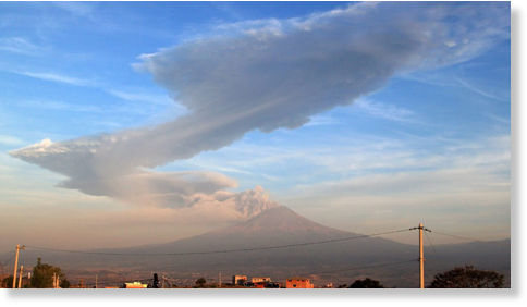
© APA large plume of ash rises from the Popocatepetl volcano as seen from the highway to Atlixco, Mexico early Friday, June 3, 2011.
Mexico's largest active volcano has spewed ash and smoke into the air on Sunday, and local civil protection authorities warned people not to go close as burning ash could fall for hours, reported China's Xinhua news agency.

The Popocatepetl volcano, 60 kilometres (km) southeast of Mexico City, were clearly visible from the capital and nearby cities of Puebla, Morelos and Mexico State.

Access to the volcano has been restricted to a radius of 12 km around the crater following a powerful explosion, which was reported at 12:05 p.m. local time (1805 GMT).

The explosion caused the earth to shake and sent smoke and ash over 7 km high into the air, and has alarmed some 20 million people living nearby.

However, officials said that no casualties or damages had been reported so far, Xinhua reported.

The Popocatepetl volcano is 5,452 meters high and located in the Trans-Mexican Volcanic Belt.

Bizarro Earth

Restless underwater volcano disrupts life on Canary Island

Image
© Guardia Civil
Madrid - Steaming magma is bubbling onto the sea surface. The earth shakes, and a smell of sulphur floats in the air.

For over a month, residents of the Spanish Canary Island of El Hierro have lived with an active underwater volcano that not only poses a security threat, but also scares off tourists and endangers the inhabitants' livelihoods.

Volcanic eruptions could continue for weeks, civil protection science representative Carmen Lopez said this week.

However, the situation has been deemed safe enough for the 550 evacuated residents of the fishing village of La Restinga to return home, though the island was still being hit by earthquakes.

The earth began trembling on El Hierro on July 19, in a sign that magma was rising toward the surface of the smallest Canary Island.

Attention

Italy: Etna erupts for eighteenth time this year

Mt. Etna
© Dr. Boris BehnckeStrombolian activity at Etna as seen on July 5, 2011.
Etna has intensified its activity today with fountains of lava and ash causing restrictions to air traffic. This eighteenth eruption this year has followed the Stromboli pattern as previous ones did and lasted just a couple of hours. The Crisis Unit at the Catania Fonatanrossa Airport met to assess potential consequences for flights and restricted air space until 16.30 without however affecting passenger flights.

Bizarro Earth

US: Hawaii's Kilauea Volcano Lava lake sinks, spurring quakes

Image
© Hawaiian Volcano ObservatoryA large "skylight" in the Puu Oo lava field permits a view of a tube supplying lava to surface flows north of Royal Gardens subdivision. The tube, which heads southeast, is marked by the line of fume sources in the upper-right portion of the image.
Eight small earthquakes rocked Kilauea Volcano after the lava lake at the summit caldera dropped in elevation Sunday, U.S. geologists reported.

But that seismic shaking was actually below normal levels, they said.

The strongest quake was a magnitude 3.3 at 2:16 a.m. Sunday.

At Puu Oo, meanwhile, a "skylight" in the pahoehoe (smooth, ropy lava) field showed a tube transporting lava on the southeast flank to active flows about three miles to the south.

The active lava flows are within the Kahauale'a Natural Area Reserve, which remains closed to the public because of various hazards - including potentially lethal concentrations of sulfur dioxide - so they are visible only from the air.

But the glow from the vents and flows can be seen from the Hawaii County viewing area at Kalapana if weather conditions are right, said scientists with the U.S. Geological Survey.

Bizarro Earth

Congo Mount Nyamulagira Volcano: Tourists Invited To See Eruption

A national park in Congo best known for its endangered mountain gorillas is now inviting tourists to go on overnight treks to see a volcano spurting fountains of lava nearly 1,000 feet into the air. Mount Nyamulagira began erupting on Nov. 6 and could continue to do so for days, or even months. "Last night's was the most spectacular yet," spokeswoman LuAnne Chad said Monday from Virunga National Park.

Arrow Up

El Hierro Underwater Volcano's Eruption in Photos

Image
A brand new Canary island is emerging from the sea as an underwater volcano bubbles to the surface.

Magma off the Canary Island of El Hierro has been spewing 20 metres high as the sea boils with a smell of sulphur.

As it grows and gets closer to the surface, more and more debris such as stones start to shoot out of the volcano which, until now, has only shown its explosive power below the surface.

It is now just 70 metres from the surface and islanders are already trying to come up with a name for the new island. It is quite close to El Hierro and if it continues to erupt it could eventually meet up with the mainland.

Bizarro Earth

First Picture Emerges of Infant Underwater Volcano

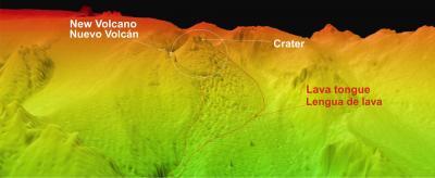
New Volcano
© IEO/MICINNThis image was recently taken and shows the new volcano and its lava tongue that descends in the path of the old underwater valley.
It is rare that the birth of an island can be watched by humans in real-time, but that could be what is happening in Spain's Canary Islands.

Residents of La Restinga on the island of El Hierro were recently evacuated after weeks of earthquakes and the growing threat of an erupting underwater volcano that is making its presence known on the surface with an expanding, bubbling patch of dark debris.

The seismic activity off the coast alerted scientists to the fact that something interesting was happening under the sea. To get a better look, a team of researchers from the Spanish Institute of Oceanography (IEO) went out on the water and were able to get a high-resolution picture of the volcano in less than two weeks.

The volcanic cone stretches nearly 330 feet (100 meters) above the seafloor, and is 2,300 feet (700 m) wide at its base. Lava is currently oozing out of a crater in the center that is about 390 feet (120 m) wide.

Bizarro Earth

Villages deluged with ash from Indonesia's Merapi eruption now fear for their lives

Image
© AntaraA local watches a makeshift bamboo bridge damaged from cold lava floods from the Merapi volcano on Wednesday
Sleman, Central Java - The arrival of the rainy season has triggered the time bomb experts have long feared: volcanic mudflows comprised of millions of tons of ash and debris blanketing Merapi's slopes after last year's eruptions.

The impact is spreading this week. Mudflows are affecting not just residents of Sleman's north and east, but those in the west as well as the Progo River threatens Kisik 1 village, which sits about 1.2 kilometers from its edge.

The river has experienced extreme shallowing due to the sedimentation of ash. Volcanic mud has repeatedly spilled over its banks and flooded residents' homes, gardens and rice fields.

Past experience has made Kisik 1 resident Samirin wary.

"If there's mudflow in the Putih and Krasak rivers, it is bound to end up in the Progo River," he said. "Almost all the levees are damaged or have been washed away. Even the east bank of the river, which was four meters high, has been washed out."

Bizarro Earth

Eruption continues unabated at Chile's Puyehue Cordón-Caulle volcano

Despite being classified as a "minor" (menor, in Spanish) eruption, Chile's Puyehue Cordón-Caulle Volcano continues to pump out large amounts of ash. This natural-color satellite image shows the pale plume blowing to the northeast of the active vent.
Image
© Earth Observatory / NASA
According to SERNAGEOMIN, the Chilean National Service of Geology and Mining, ash rose to a height of 5 kilometers (3 miles), and blew as far as 300 km (190 miles) from the volcano. Wide-area satellite images show the full length of the plume, and ash covering the Argentinian plains to the east of Puyehue Cordón-Caulle.