Extreme Temperatures
S


Snowflake Cold

Intense snow blizzard strikes the western half of Iceland

Goðafoss, North Iceland in a blizzard
© Zhana-AulGoðafoss, North Iceland in a blizzard
A relatively short but intense snow blizzard event is expected across the western half of Iceland tomorrow morning, Saturday, Jan 4th. The event is related to the rapidly intensifying cyclone to the northwest of Iceland, creating dangerous heavy snowfall and severe winds with blizzard conditions across the Southern Peninsula, the capital Reykjavik, Snæfellsnes and Westfjords. Heavy snowfall changes to rainfall during the day due to strong warm advection from west to east, but remains over the Highlands.

The pattern responsive for this severe event is a new trough developing from the Labrador Sea towards southern Greenland, developing an intense cyclone towards Iceland. Conditions will worsen significantly with the rapid intensification of the cyclone. A strong ridge expands to the south across the rest of North Atlantic and west-southwest Europe.


Comment: Just under 3 weeks ago: Up to 30 FEET deep snow banks in Iceland - 'We've never before had snow on this scale'


Snowflake

Summer snow falls on hills in Southland, New Zealand

snow map
Snowfall for 6 hrs ending Tuesday 07 Jan at 1am NZDT
Southlanders could be forgiven for thinking it was the middle of winter as they woke to snow on the hills on Monday morning.

Snow fell in the high country in Northern Southland overnight on Sunday as a January cold snap continued in the province.


Out on the coast, Metservice issued a strong wind warning for southwest gales up to 120kmh for coastal Southland, Clutha and Stewart Island, warning gusts in exposed places could bring down trees and powerlines.


Snowflake Cold

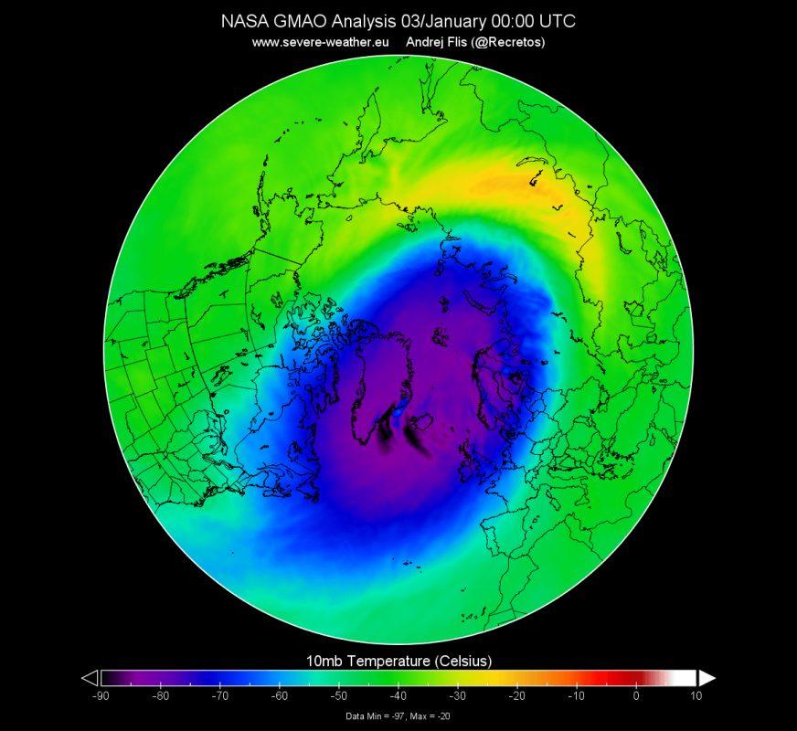
Stratospheric polar vortex reaches coldest temperature in 40 years

polar vortex
The graph shows the lowest temperature across the Northern Hemisphere, from 50-90°N latitude, where the coldest area of the polar vortex usually is.
The polar vortex has been gaining strength and has reached its peak climatological strength. It is set to be connected with the lower levels, pushing its influence on the weather patterns.

On January 3rd, a radiosonde has made measurements of the mid-stratospheric layers. Measuring over Reykjavik, Iceland, it has recorded the lowest temperature in the stratosphere in the past 40 years, at -96°C (-141°F). The image and data below from the Universtiy of Wyoming, shows the direct measurements made, where we can see the temperature line disappearing below -90°C near the 20mb level. The raw data shows the temperature and altitude, where we can see the -96°C being reached at 17.2mb level, which was around 25.6 km altitude.

Comment: See also: And check out SOTT radio's:


Ice Cube

Ice builds along the rushing Missouri River in Bismarck, North Dakota

ice river
North Dakota resident Mike Odegaard captured video of an ice jam that formed through Hoge Island on the Bismarck side of the Missouri River on New Year's Day.

The video shows ice sheets piling on the shores of the river bank.


Arrow Up

Smoke and deception blanket Australia

We've been hearing much fake news about the Australian bush fires supposedly having been caused by man-made climate change. Yet it has emerged that Australian authorities were warned years ago that poor land management practices were in fact escalating the risk of devastating fires, according to an expert.

Forest fuel level highest in 1000 years

In 2015, bush fire scientist David Packham warned of a "huge blaze threat" and urged an "increase in fuel reduction burns".

"Forest fuel levels had climbed to their most dangerous level in thousands of years," wrote Darren Gray here in 2015. Today the public is being misled by climate alarmists and the media on the real causes of the devastating bush fires now taking place.

In fact NASA data shows that the area burned by global wildfires dropped by 25% since 2003, according to the Global Warming Policy Forum (GWPF)

Temperature Trends Australia
© NASA GISS

Snowflake

Athens-Lamia highway in Greece shuts down due to heavy snowfall

snow road
The Athens-Lamia Highway shut down completely for approximately five hours on Monday afternoon due to heavy snowfall.

The highway is the main artery which connects the city of Athens with Lamia and then continues all the way north up to Thessaloniki.

Police decided to shut the highway down near the Afidnes tollbooth in Attica, because of the extremely poor weather and road conditions which were prevailing in the area.


Ice Cube

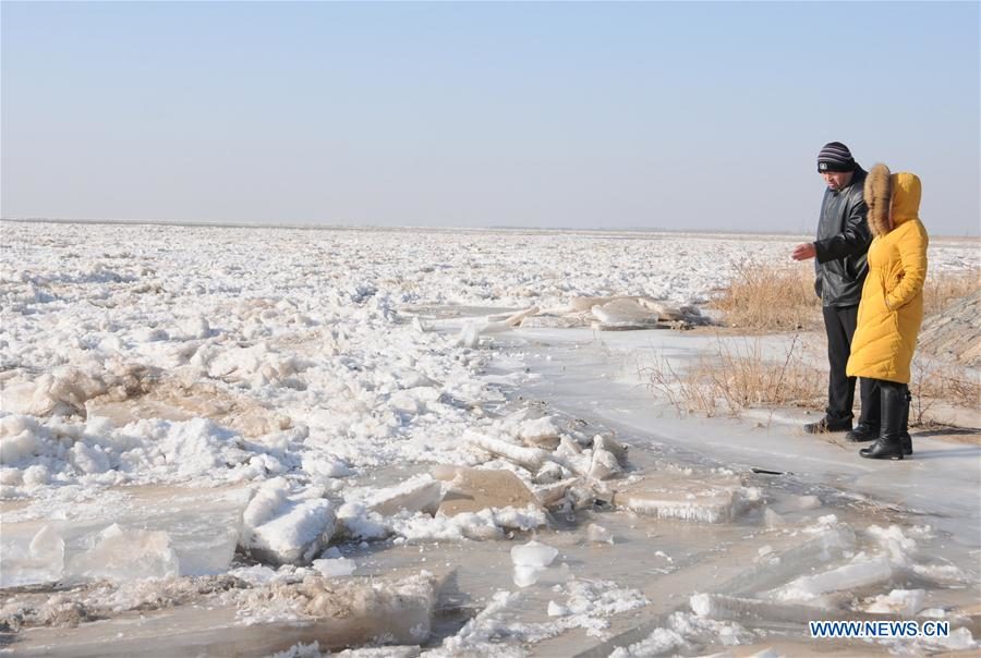
560 kilometers of China's Yellow River frozen solid

Photo taken on Jan. 3, 2020 shows the frozen Linhe section of the Yellow River
© Xinhua/Li YunpingPhoto taken on Jan. 3, 2020 shows the frozen Linhe section of the Yellow River in Bayan Nur City, north China's Inner Mongolia Autonomous Region. Driven by cold temperatures, the frozen section of China's Yellow River in north China's Inner Mongolia Autonomous Region has reached 559.9 km as of Jan. 3, according to local authorities.
Driven by cold temperatures, the frozen section of China's Yellow River in north China's Inner Mongolia Autonomous Region has reached 559.9 km as of Jan. 3, according to local authorities.

The flood control headquarters of the Yellow River announced the river entered its 2019-2020 frozen period at 10 a.m. on Dec. 6, 2019.

The meteorological and hydrology departments in the region and local authorities along the river have taken precautions against ice-jam flooding and dam breaches, said Qiao Jianzhong with the water affairs bureau in Linhe District, Bayan Nur City.

Snowflake Cold

Greenland just set a new all-time record low temperature

Summit camp, Greenland


Summit Camp, also known as Summit Station, is a year-round research station on the apex of the Greenland Ice Sheet. It is located some 10,500 ft (3,200 m) above sea level, and it's data is often cited by climate alarmists claiming "Greenland Is Melting Away Before Our Very Eyes" and other such nonsense...


Adding to the list of temperature measurements those alarmists will likely ignore -or won't even get to hear about given the mainstream media's warm-bias- is Summit Camp's preliminary low of -86.8F (-66C) set at 11:13 PM on January 02, 2020.

The reading, once confirmed by the DMI, will enter the books as Greenland's coldest-ever recorded temperature-not only at Summit Camp, and not only in January, but of anywhere across the island, and of any month of the year.

Summit camp temps table
Somehow, in what we're to believe is a linearly warming world, Greenland -the poster boy for global warming- is currently the coldest we've ever known it to be.

Comment: Gulf Stream is 15% weaker, region south of Greenland coldest in 1,000 years


Arrow Up

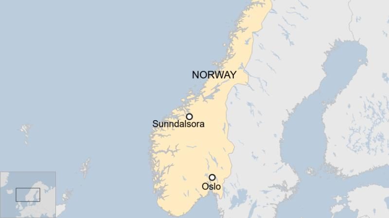
Norway records warmest ever January day at 19C

Sunndalsora, Norway
© BBC
Western Norway is experiencing a rare heatwave for early January, at a time when temperatures should normally be below freezing.

The highest temperature of 19C (66F) - more than 25C above the monthly average - was measured in the village of Sunndalsora.

This makes it Norway's warmest January day since records began.

While many were enjoying the warm weather, there are concerns that it is another example of climate change.

"It's a new record for warm weather here... People [have been] out in the streets in their T-shirts today," Yvonne Wold, mayor of the municipality of Rauma, who had taken a dip in the sea earlier in the day, told the BBC.

"A lot of people are usually skiing at this time. Not exactly much of that today," she added.

Comment: The Foehn Effect may have also contributed to Northern Scotland registering a "remarkable" overnight temperature of 16.8C (62.2F) in the early hours last Sunday - a record high for this time of year.

However, the record-breaking temperatures, lows and highs, being recorded around the globe these days are likely influenced by a rapidly changing jet stream. See also:

Adapt 2030 Ice Age Report: Jet streams break while 'once in a century' is our new norm


Snowflake

Indian state of Nagaland gets its first snowfall in 40 years

Photo (left to right): Instagram/daisy__choudhury; ashuzhiio_chobotte; asakho_chase
Parts of Nagaland saw snow for the first time in decades—and more may be on the way

It may have taken a while—four decades as some reports claim—but it finally snowed in parts of Nagaland last week and it's turned the region into a winter wonderland. The rolling green mountains and meadows in the districts of Zunheboto, Kiphire, Phek and Tuensang were blanketed in fresh powder due to a biting cold wave in northeast India.

Nagaland weather in January 2020

Snow is an uncommon phenomenon in Nagaland. At this time of the year, the temperature usually drops to 10-11°C, but last week, the temperatures dropped to 2-3°C. Several other parts of the northeast are also experiencing extreme cold conditions. Itanagar in Arunachal Pradesh on Monday was the most frigid city in the northeast on Monday at a temperature of 2.9°C. The conditions were similar in Imphal in Manipur, while Shillong reported a low of 5°C.